![]()
![]()
![]()
Use LEFT and RIGHT arrow keys to navigate between flashcards;
Use UP and DOWN arrow keys to flip the card;
H to show hint;
A reads text to speech;
77 Cards in this Set
- Front
- Back
|
Define Oceanography |
The study of the physical and/or biological parameters of the ocean through geologic time. |
|
|
What are some reasons to study oceanography? |
1. General Education Requirement (GER) 2. Climate effects (Currents transport heat globally) 3. Size (Oceans are 70-80% of the world) 4. Conservation efforts 5. Food (<3% from oceans, rare and expensive) 6. Transportation 7. Energy (petroleum drilling, hydroelectricity, geothermal, wind, total energy) 8. Products (petroleum, salt, chalk, sand, gravel for concrete, hydroelectric energy, clay) |
|
|
What is the world's largest ocean? |
Pacific |
|
|
The breakdown of oxygen in H2O results in methane geysers, and therefore dead zones. This location is the most well-known dead zone in the world. |
Bermuda Triangle |
|
|
This is the most important concept in geology, and everything can be reflected back to this (development of life on earth) |
Plate tectonics |
|
|
There are two theories used to explain the creation of the earth are: |
Cold accretionary model and hot accretionary model |
|
|
In this model, the big bang occurs, releasing substances that were harnessed by gravity and "spun" into a molten ball of matter. |
Hot accretionary model |
|
|
In this model, the big bang occurs, and pieces of matter collided, cooled, and added to form planets that then melted together, forming a molten mass. |
Cold accretionary model |
|
|
Which theory does Zumwalt believe to be correct? |
Cold accretionary model |
|
|
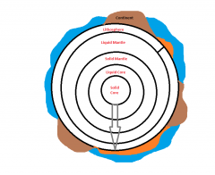
This is the solid sphere composed of multiple parts (plates). Beneath it is lava. Its height is controlled by the weight and density of the sphere itself. (Think of a boat floating in water) |
Lithosphere |
|
|
Points of Interest *The liquid mantle is referred to as the aesthenosphere *Heat convection pushes lithosphere up to form large ridges *Oceanic crust is the same composition as the litosphere
|
|
|
Where did oceanic H2O come from? |
Magma; water vapor cools and fills the crevices in the lithosphere |
|
|
Gravitational differentiation speculation Key points: Red indicates heavy materials |
|
|
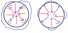
*Each earth component spins at a different rate with the inner core moving most slowly and the outer crust moving most quickly. *Layers spin past one another, generating large magnetic fields that cancel each other out *What we feel at the surface is the result, and this changes throughout time *Magnetic reversals happen at the surface *North/south configs switch based on the internal movement
|
Ok |
|
|
Plates can move in three directions, relative to one another. They can: |
Converge, diverge, or move past one another |
|
|
Where does most plate movement occur? |
At boundaries |
|
|
DIVERGENCE *All Lithospheric plates and oceanic crust are formed in the RIFT ZONE in the mid-oceanic ridge *Where midoceanic ridge extends above sea level, islands are formed
|
|
|
This is a flat-topped volcano. |
Gyote |
|
|
This is another name for sea level dropping |
Regression |
|
|
What is the largest geologic feature on the globe? |
Abyssal Plane |
|
|
Convection causes lithospheric plate divergence. How much movement is caused per year? |
5cm/year |
|
|
When displacement occurs, what happens as a result? |
Sea level rises |
|
|
When water flows out of the basin and onto continents, movement of shoreline toward the center of the continent occurs. This is also known as: |
Transgression |
|
|
This primarily controls sea level. |
The rate of convection |
|
|
This is a break in rock in which motion occurs. |
Fault |
|
|
This is a volcano away from a heat source |
Sea mount |
|
|
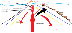
CONVERGENCE Key Points: *3 kinds of convergent boundaries based on what lithospheric plates are carrying (oceanic crust or continental) *Oceanic-oceanic convergence *oceanic-continent convergence (Shown in the pic) *Continential-Continential
|
|
|
These are accumulations of sediment against the continental crust as convergence occurs |
Melange
|
|
|
These are accumulations of buckled pieces of oceanic crust building up against the continental crust as convergence occurs |
Ophiolites |
|
|
Sea mounts and gyotes are scraped off and added to the edge of the continent. These resulting land forms are referred to as: |
Exotic terrain |
|
|
What is the difference between a sea mount and a gyote? |
Gyotes are flat topped and in shallow water. Sea mounts are pointed and always in deep water. |
|
|
When was the Atlantic Ocean the largest? |
Today because the Atlantic Ocean is constantly growing |
|
|
When was the Pacific Ocean at its largest? |
Millions of years ago before the Atlantic Ocean and Indian Oceans began (180 mya) |
|
|
The ocean system is this type of system: [static/dynamic] [open/closed] |
Dynamic Closed |
|
|
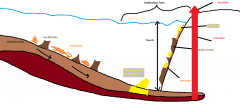
In Oceanic-Continential Convergence, this main interaction occurs between the oceanic crust and the continental crust. |
Oceanic crust is pushed beneath the continent
|
|
|
This term refers to the sliding of oceanic crust beneath a continent, occurring in a particular zone named for this phenomenon. |
Subduction (Subduction zone) |
|
|
This is deep water off the edge of a continent. |
Trench |
|
|
The oceanic crust and lithospheric plates are consumed in this area: |
Subduction zone |
|
|
This is world's deepest trench. |
Mariana's Trench |
|
|
How deep is Mariana's Trench? |
11,000+ meters or 36,000+ feet. |
|
|
These are also called Magellan Blocks. |
Exotic Terrain |
|
|
Where would you go to find evidence of accreation? |
Oregon, Nevada, Arizona, etc. West coast states, because they are composed fully of secreted materials |
|
|
Where is the North American subduction zone? |
Californian coast, extending N/S |
|
|
Which is the highest mountain in the Himalayas? |
Mount Everest and K2 are about the same height |
|
|
Where would you find the oldest pieces of oceanic crust? |
In ovulites on land |
|
|
In Oceanic-Oceanic convergence, this occurs: |
One piece slides beneath another. Extrusion occurs (volcanoes) |
|
|
What is the closest example of oceanic-oceanic convergence to us? |
Sierra Nevada Mountains (Mesocordilleran geanticline??; volcanic during mesozoic time and in the west coast US) |
|
|
In continential/continential collisions, these land masses are a direct result: |
Large scale mountains with material forced into the sky and down into the aesthenosphere. Example: Appalachian Mts. |
|
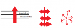
This intraplate phenomenon is when point convections within the aesthenosphere melt through the overlying plate |
Hot spots/plumes Note: Lava and magma stream in all directions, resulting in no plate motion bc all vectors cancel |
|
|
This is the bent path as a result of plates changing direction. |
Nematath (A submarine ridge across an Atlantic-type ocean basin which is not an orogenic structure, but which is composed of otherwise undeformed continental crust) |
|
|
This is when heat forms a convection cell within large continents, sometimes causing continents to rift |
Insipient Ridge System |
|
|
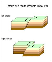
This is a series of faults that allow plates to move past one another. |
Transform fault boundaries Ex: San Andreas Fault |
|
|
*Occurs in pairs, appearing straight *Lots of Left Laterals in a row = overall feature bends left *Lots of Right Laterals in a row = overall feature bends right |
|
|
Why do right and left lateral orientations occur? |
They are fitting linear features to the spherical shape of earth |
|
|
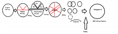
What two major events make up the supercontinent cycle? |
Rifting and subduction *WATCH SUPERCONTINENT CYCLE VIDEO* |
|
|
Gonduanaland - Africa, South America, Australia, Antarctica |
|
|
How does Pan III occur? |
All of Pan III except Antarctica will be forced across Antarctic spreading ridge. Its new location will be around the south pole which will result in a large glaciation |
|
|
What was the result of North America hitting Gonduanaland? |
Southern mountain ranges of the US, eventually Pan II |
|
|
What causes rifting? |
Insipient ridges |
|
|
What is the cycling time of rifting and suturing? |
300 million years |
|
|
How many Pangaeas have we had? |
15+ |
|
|
What causes transgressions and regressions? |
Convection -> Water displacement |
|
|
What are the climate-related effects of plate tectonics on small continents? |
Temperature stays relatively the same (about the same as water) *Maritime climatic regime |
|
|
How is climate predicted on a global scale? |
Weather is predicted based on sourced air flow |
|
|
Why can tropical systems support many more organisms that polar regions? |
There are very few organisms that can adapt to very cold environments
Remember: Plate tectonics controls the number of species and what species live in a region |
|
|
Trophic Resource Stability follows the same gradients as: |
Climate |
|
|
This is the total number of provinces a defined area, usually globally, contains |
Provinciality |
|
|
Organisms that have similar physiological tolerances live in the same ____ |
Community |
|
|
Naturally occurring groups of organisms that are genetically similar enough to breed and form a viable offspring |
Species |
|
|
What are examples of reproductive isolating barriers? |
Deep water, land, temperature |
|
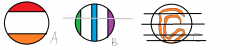
How many shallow water provinces are in each image? |
A. 2 B. 32 C. 22 |
|
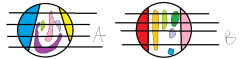
How many shallow water provinces are in each image? |
A. 68 on this side, 54 total B. 35 on this side, 56 total |
|
|
What is the max number of provinces the earth can have? |
32 |
|
|
How many provinces exist today and why? |
31 bc so many n/s orientations exist |
|
|
How many deep H2O provinces are there? |
Just one |
|
|
What are isolating barriers for terrestrial areas? |
Oceans and temperature Note: count the pieces on the picture |
|
|
What three things does the size of a wave depend on? |
Velocity, fetch (area over which wind blows), and time |