![]()
![]()
![]()
Use LEFT and RIGHT arrow keys to navigate between flashcards;
Use UP and DOWN arrow keys to flip the card;
H to show hint;
A reads text to speech;
16 Cards in this Set
- Front
- Back
- 3rd side (hint)
|
Vad står GIS för? |
Geografic information system |
|
|
|
Vilka är de viktigaste komponenterna? |
Data, håll vara, mjukvara, his junkie person |
4st |
|
|
Vektor |
Punter och linjer ex: vägar |
|
|
|
Raster |
Rutnät ex: markanvändning |
|
|
|
Nämn funktioner som finns i GIS |
Georeferensing, overlay, classification, buffer, uträkning och kart algebra |
6 st |
|
|
Coordinate system |
Referenssystem för att representera en viss plats på jorden |
|
|
|
Nämn 2st koordinatsystem som används i Sverige |
RT90 SWEREF99TM |
|
|
|
Geographic coordinate system |
Globalt koordinatsystem |
GCS |
|
|
Projected coordinate system |
Projektion från 3dim -> 2dim |
|
|
|
Orthographic |
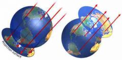
Ljuset går parallellt genom jorden |
Typ av projektion |
|
|
Stereographic |
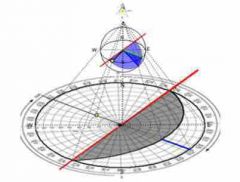
Ljuset går från nord/syd och sprider sig nedåt/uppåt |
Typ av projektion |
|
|
Stereographic |
Ljuset går från nord/syd och sprider sig nedåt/uppåt |
Typ av projektion |
|
|
Gnomonic |
Ljus från centrum |
Typ av projektion |
|
|
Azimutal |
Karta med utgång från specifik punkt |
Typ av projektion |
|
|
Conic |
Kon över jorden |
Typ av projektion |
|
|
Cylindric |
Cylinder kring jorden |
Typ av projektion |