Reading...
![]()
Play button
![]()
Play button
![]()
Use LEFT and RIGHT arrow keys to navigate between flashcards;
Use UP and DOWN arrow keys to flip the card;
H to show hint;
A reads text to speech;
87 Cards in this Set
- Front
- Back
|
latitudes
|
parallels, N/S
|
|
|
Longitudes
|
meridians, E/W
|
|
|
Plankton plus nekton vs benthos
|
2%/98%
|
|
|
Marine vs Land Species amounts
|
14% vs 86%
|
|
|
Less marine species because
|
environment more stable, less diverse
|
|
|
most biomass on earth
|
plankton
|
|
|
two types of plankton
|
phystoplankton zooplankton
|
|
|
3 types of phytoplankton
|
coccolothiphores, diatoms, some dinoflagellates
|
|
|
Shells of Coccolithophores/diatoms/zoo plankton foraminifer/radiolara
|
Calcium Carbonate, Silica, Calcium Carbonate, Silica
|
|
|
epifauna
|
surface of sea floor benthic organisms
|
|
|
infauana
|
benthic organisms buried in sediments
|
|
|
nektobenthos
|
swim crawl through water above sea floor
|
|
|
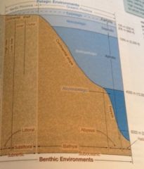
neritic
|
less than 200 meters from surface
+ oceanic = pelagic |
|
|
Light can't penetrate
|
below 200 meters
|
|
|
euphotic
|
light sufficient for photosynthesis
|
|
|
disphotic
|
small light
|
|
|
aphotic
|
no light
|
|
|
neritic province is water over
|
continental shelf
|
|
|
bathy is water along
|
continental slope
|
|
|
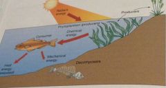
Sun to trophic level 1 =
|
2% efficiency, 98% of energy lost.
Each level after that is 10% efficient. |
|
|
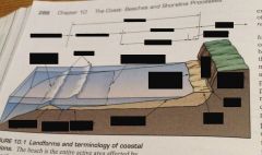
Coast
|
inland to line of dunes/cliff (all the way to turnpike)
|
|
|
Shore
|
coastline to low tide line
|
|
|
Foreshore
|
area between high and low tide line
|
|
|
Backshore
|
end of high tide - coastline
|
|
|
Beach
|
sediment from nearshore to coastline
-entire area of coast affected by waves |
|
|
longshore current produced by
|
wave refraction; in and out at different angles
|
|
|
swash/backwash
|
water in/water out
|
|
|
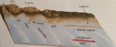
longshore drift
|
movement of sand
|
|
|
depositional shore subject to
|
sand subsiding or water level rising
|
|
|
peat
|
decaying organic matter under salt marsh
|
|
|
barrier island migrate
|
inward
|
|
|
sea vas ocean
|
sea is smaller/shallower
composed of salt water somewhat enclosed by land directly connected to the world ocean |
|
|
Relative ocean sizes:
|
Pacific 50%
Atlantic 26% Indian 20.5 & |
|
|
Ocean depth vs elevation
|
average depth and deepest greater than average height and elevation
|
|
|
Heyerdahl
|
proposed that voyagers from s. america first to reach south pacific - proved it possible by sailing the Kon Tiki
|
|
|
Phoenicians
|
first humans to develop art of navigation
|
|
|
pytheas
|
sailed using north star
|
|
|
eratosthenes
|
determined earth's circumference
|
|
|
ptolemey
|
produced a world map
|
|
|
first submersibles
|
Beebe and his bathysphere
Ballard and Alvin |
|
|
nebular hypothesis
|
all bodies in solar system formed from an enormous cloud composed mostly of hydrogen and helium.
Magnetic fields caused it to revolve around center and become sun. Contracted but small elements left behind as whirlpools - protoplanets |
|
|
protoearth
|
larger, neither ocean nor life, shrank and chemicals to to fusion of sun
homogeneous composition throughout |
|
|
outgassing
|
gasses dispelled from earth that rose to create second atmosphere - first blown away by sun's solar wind
|
|
|
formation of oceans:
|
volcanic activity released water vapor
earth cooled, vapor condensed into clouds and rained accumulated to form oceans |
|
|
earliest fossil
|
bacteria in sea floor rocks; 3.5 billion years old
|
|
|
oxygen important for 2 reasons
|
releasing energy in our cells
ozone protects earth from suns UV radiation |
|
|
miller's experiment
|
mixture of gases thought to be in earth's atmosphere/ocean and sent a spark. Mixture formed organic molecules including amino acids.
|
|
|
3 domains
|
archaea, bacteria, eukaryo
|
|
|
5 kindgdoms
|
monera, protista, fungi, plantae, animalia
|
|
|
seed bearing plants
|
anthophyta
|
|
|
macroscopic algae
|
brown, green, red
|
|
|
microscopic algae
|
golden, diatoms, coccolithophores, dinoflagellates
|
|
|
suspension feeding =
|
filter feeding
|
|
|
deposit feeding
|
feeding on dead/decaying organic matter and waste or sediment itself (coated with organic matter)
worms |
|
|
berm
|
dry gently sloping region at the foot of the coastal cliffs or dunes, favorable place for beach goers
|
|
|
wave cut bench
|
flat wave eroded surface
|
|
|
beach
|
deposit of the shore area consisting of wave worked sediment
|
|
|
beach face
|
wet sloping surface that extends from berm to the shoreline; partially exposed during low tide
|
|
|
longshore bar
|
sand bars parallel to coast
|
|
|
longshore trough
|
separates longshore bar from beach face
|
|
|
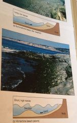
summertime beach
|
light wave activity produces a wide sandy berm and overall steep beach face at expense of longshore bar
|
|
|
wintertime beach
|
heavy wave activity produces a narrow rocky berm and an overall flattened beach face that builds prominent longshore bars
|
|
|
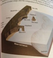
headland/sea arch/sea stack
|
wave energy concentrated on a jutting portion of land
sea arch caused by waves eroding, sea stack = further erosion of arch |
|
|
wave cut cliffs/sea caves
|
formed by upper portions around headlands to collapse down which can form sea caves below
|
|
|
marine terrace
|
uplift of wave cut bench
|
|
|
spit/hook
|
linear ridge of sediment that extends in direction of drift
|
|
|
baymouth bar
|
cuts off bay from ocean, sand accumulation due to lack of tidal forces
|
|
|
tombolo
|
sand ridge that connects an island or sea stack to mainland
|
|
|
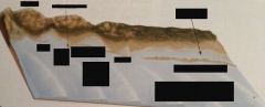
barrier island
|
long offshore deposits of sand parallel to coast
|
|
|
set up of barrier island
|
from ocean inward - ocean beach, dunes, barrier flat, high salt marsh, low salt marsh, lagoon
|
|
|
isostatic movement
|
vertical movement of crust - sinking under accumulation of ice, sediment, or lava
rising when accumulation removed |
|
|
eustatic changes
|
experienced worldwide, icea ges, climate changes, global warming
|
|
|
7 Size ranges of sediment
|
Clay, Silt, sand
Gravels: Granule, pebble, cobble, boulder Can scuba steve grow pretty crappy boulders |
|
|
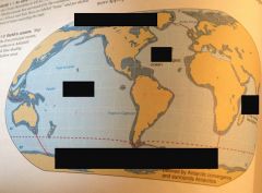
pacific middle, indian far right, atlantic middle up, southern bottom, arctic top
|
|
|
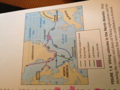
vikings
|
|
|
|
|
|
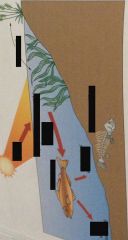
beaches
|
|
|
|
|

|
water
|
|
|
beach
|
|
|
|
|
|
|
|
|
Eras
|
Precambrian
Paleozoic - invertebrates Mesozoic - reptiles Cenozoic - mammals |
|
|
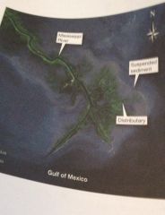
Delta
|
fertile lat low lying area
|
|
|
delta formation
|
sediment carried by river faster than current can take it away
distributed by extensions |
|
|
erosional vs depositional shore
|
cali vs us
|
|
|
oceans all
|
interconnected, 97% of water
|