Reading...
![]()
Play button
![]()
Play button
![]()
Use LEFT and RIGHT arrow keys to navigate between flashcards;
Use UP and DOWN arrow keys to flip the card;
H to show hint;
A reads text to speech;
40 Cards in this Set
- Front
- Back
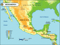
Where is Mesoamerica located?
|
Mesoamerica is a region that extends from southern North America (about the middle of Mexico) to the middle part of Central America (as far south as Costa Rica).
p.159, 163 |
|
|
List three physical features of the interior of MesoAmerica.
|
1. Sierra Madre Mountain ranges -- one on each side of Mexico.
2. Plateau of Mexico -- high, flat area between the Sierra Madres. 3. Volcanos -- south of the Plateau of Mexico. 4. Coastlines -- No place in Mesoamerica is more than 200 miles from an ocean coastline. 5. Yucatan Peninsula -- a huge peninsula that forms the southeastern border of the Gulf of Mexico. p.163-164 |
|
|
Name three crops grown in Mesoamerica.
|
1. Maize (corn)
2. Beans 3. Squash 4. Chili peppers 5. Tomatoes 6. Cacao Beans 7. Avocado 8. Fruit p. 163, 165, 173, 179 |
|
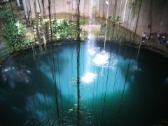
What do cenotes provide for the people of Mesoamerica?
|
Cenotes provided drinking water. The Maya believed cenotes were a way to communicate with the gods, and Mayan priests made sacrifices to them.
p. 164, 171 |
|
|
How did the landscape of Mesoamerica influence the people who lived there?
|
Most were farmers. The landscape and climate affected the crops they raised.
p. 169 |
|
|
The Olmec people were divided into social classes based on what?
|
The Olmec people were divided into social classes based on wealth and power.
p. 169 |
|
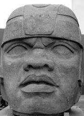
Who were the most powerful classes in Olmec civilization?
|
The most powerful Olmec classes were the the priests and government officials.
p. 169 |
|
|
Why are the Olmec called the "Mother Civilization" of Mesoamerica?
|
The Olmec directly influenced all of the Mesoamerican civilizations that followed it.
p. 169 |
|
|
How were the Maya different from the Olmec?
|
The Maya writing system was more complex.
p. 171 |
|
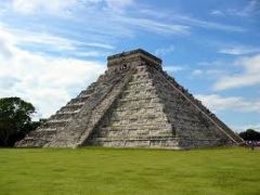
Why do many archaeologists believe that the Olmec may have been ancestors of the Maya?
|
The Olmec and Maya cultures have many common features: agriculture, stone construction, astronomy, calendars, polytheism, number systems, and hieroglyphics. Both lived in a theocracy, with cities designed to pay tribute to the gods. And no one knows what became of the Olmec.
p. 169, 170 |
|
|
Name three reasons why the Maya used calendars.
|
The Maya used calendars to:
1. record events like births, marriages, military victories. 2. keep track of the sun, moon, and stars 3. keep track of religious rites and worship p. 172 |
|
|
What did the Aztecs call themselves when they were just one of many Mesoamerican peoples?
|
They called themselves the Mexica.
p. 176 |
|
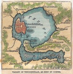
Where was Tenochtitlan built?
|
Tenochtitlan was built on islands in Lake Texcoco, in what is now Mexico.
p. 176 |
|
|
When Tenochtitlan became overcrowded, how did the Aztecs expand the city?
|
The Aztecs built man-made islands call chinampas.
p. 176 |
|
|
What does this statement mean: "The Mexica formed alliances to help their power grow."
|
This means that the Mexica agreed to work together with other people in order to increase their power.
|
|
|
Why might the Aztec Empire have continued had Cortes not attacked?
|
Before the Spanish arrived, the Aztecs were enjoying their greatest period of wealth and power.
p. 180 |
|
|
Name at least four facts to support the following opinion: "The landscape of Mesoamerica is interesting and beautiful."
|
The landscape is extremely varied. It includes ruggedy mountains, deserts, rain forests, ocean coastlines, grasslands, swamps, pine forests, volcanoes, and caves.
p. 163, 164 |
|
How were the Olmec and Aztec civilizations alike?
|
1. Both were based on agriculture.
2. Both built stone cities and temples. 3. Both left written records in hieroglygics. 4. Both were polytheistic -- worshipped many gods. 5. Both were theocracies. p. 165, 175 |
|
|
How were the Olmec and Aztec civilizations different?
|
The Aztecs built a great empire.
p. 175 |
|
|
Give at least two details that support the following main idea: "The Mayan calendars served a variety of purposes."
|
1. They kept two different types of calendars: one for solar seasons and one for sacred rites.
2. The Mayans kept records of important dates such as births, marriages, and military victories of their leaders. p. 172 |
|
Suppse that you were an advisor to Moctezuma II. What might you have told him about Cortes? Should Moctezuma have allowed Cortes to enter Tenochtitlan? Why or why not?
|
You might have told Moctezuma that Cortes's arrival fulfilled the legend of the return of the light-skinned god, Quetzalcoatl. If so, Moctezuma should have welcomed Cortes to Tenochtitlan.
OR You might have told Moctezuma that the Aztecs had a proud warrior tradition and that the newcomers' hearts would make good sacrifices to the gods. Then Moctezuma would not have allowed Cortes to enter Tenochtitlan. He would have gone to war instead. p.178 - 181 |
|
|
Which civilization do you admire most: Olmec, Maya, or Aztec? Give three reasons why.
|
*
|
|
|
What type of job would you have wanted if you lived in a Mesoamerican civilization? Why would you choose this job?
|
*
|
|
|
Vocabulary - cenote
|
A sinkhole or natural well formed by the collapse of the roof of a cave or underground stream.
p. 164 |
|
|
Vocabulary - peninsula
|
An arm of land sticking into the sea so that it is nearly surrounded by water.
p. 164 |
|
|
Vocabulary - theocracy
|
In a theocracy, the leader and ruling classes are believed to represent the will of the gods.
p. 169 |
|
|
Vocabulary - aqueduct
|
Structures that carry flowing water.
p. 170 |
|
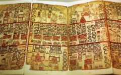
Vocabulary - codex
|
A folding-screen book.
p.172 |
|
|
Vocabulary - mercenary
|
A hired soldier.
p. 176 |
|
|
Vocabulary - chinampa
|
A man-made island.
p. 176 |
|
|
Vocabulary - causeway
|
Raised bridges made of land.
p. 176 |
|
|
Vocabulary - alliance
|
An agreement to work together.
p. 177 |
|
|
What are the four basic types of map projections?
|
1. Equal area
2. Robinson 3. Mercator 4. Interrupted p. H22-H23, p. 166-167 |
|
|
What is distortion on a map?
|
On a map, distortion is an error in size, shape, distance, or direction.
p. H22-H23, p. 166-167 |
|
|
Why must every flat map contain some distortion?
|
Because the Earh is curved and paper is flat. It is impossible to transfer exactly the image of a round object to a flat surface.
p. H22-H23, p. 166-167 |
|
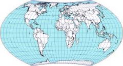
Equal-Area Map
1. Main feature. 2. Where is it true? 3. Where is distortion worst? 4. Uses |
Equal-Area Map
1. Curves longitude lines -- except the prime meridian (center line) -- toward the poles. (It looks like an oval.) 2. True at the center point. 3. Distortion worst at the edge of the map. 4. Used to compare size (but not shape) of land masses. p. H22-H23, p. 166-167 |
|
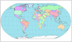
Robinson Map
1. Main feature. 2. Where is it true? 3. Where is distortion worst? 4. Uses |
Robinson Map
1. More accurately shows shape and size of landmasses. (It looks like alot like an equal-area map.) 2. True along a line between the equator and a pole. 2. Distortion increases away from this line. 3. Used for maps of the United States. p. H22-H23, p. 166-167 |
|
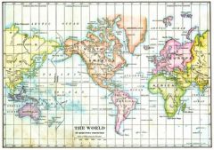
Mercator Map
1. Main feature. 2. Where is it true? 3. Where is distortion worst? 4. Uses |
Mercator Map
1. Latitude and longitude lines are straight, at right angles to each other. 2. True at the equator. 3. Distortion worst at poles, where landmasses appear larger and farther apart than they really are. 4. Used for navigation charts because it shows the true shape of landmasses. p. H22-H23, p. 166-167 |
|
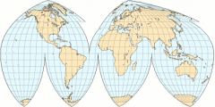
Interrupted Map
1. Main feature 2. Where is it true? 3. Where is distortion worst? 4. Uses |
Interrupted Map
1. Looks like a partially sliced, flattened orange peel. Grid is cut apart in water areas. 2. Landmasses are pretty true. 3. Water is most distorted. 4. Used to compare size and shape of landmasses. p. H22-H23, p. 166-167 |
|
|
How can you tell an equal-area map from a Robinson map?
|
Compared side-by-side, Africa is longer and skinnier on the equal-area map.
p. H22-H23, p. 166-167 |