![]()
![]()
![]()
Use LEFT and RIGHT arrow keys to navigate between flashcards;
Use UP and DOWN arrow keys to flip the card;
H to show hint;
A reads text to speech;
26 Cards in this Set
- Front
- Back
|
Technology |
The collection of tools,including machinery, modifications,arrangements and procedures used byhumans.
|
|
|
Relative Direction/Position |
Example: "In front of me" |
|
|
Absolute Direction/Position |
Example: "North of that building" |
|
|
GPS |
A space-based satellite navigationsystem that provides location andtime information in all weatherconditions, anywhere on or nearthe Earth where there is anunobstructed line of sight to fouror more GPS satellites. |
|
|
Direction |
Relative position of one point or object in relation to another point or object. Can be relative or absolute. |
|
|
Position |
Spatial location of an entity. Can be relative or absolute. |
|
|
Compass |
A lightweight magnet, generallya magnetized needle, ona free rotating pivot thataligns itself to point tothe Earth’s magneticpoles.
|
|
|
Magnetic Declination |
The angle between magnetic north (where thecompass points) and true north (the directionof a meridian line towards the geographicNorth Pole).
|
|
|
Positive Declination |
When magnetic north iseast of true north; the needle is deflected tothe right.
|
|
|
Negative Declination |
When magnetic north is west of true north; the compass needle is deflected to the left.
|
|
|
True North |
The direction of the North Pole. |
|
|
Magnetic North |
The direction of the magnetic North Pole. |
|
|
Grid North |
A navigational term referringto the direction northwards along thegrid lines of a map projection.
|
|
|
Magnetic Inclination |
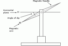
The angle made with the horizontalby the compass needle of avertically held compass. |
|
|
Secular Variation |
Declination changes with time caused by variations in theflow of molten iron in Earth's outer core, resulting in changesin the orientation of Earth's magnetic field, and hence theposition of the magnetic north and south poles.
|
|
|
Inclined Circular Orbit |
Anorbit whose inclinationin reference to theequatorial plane is notzero and has aneccentricity of near-zero.
|
|
|
Coarse/Acquisition Code |
Each GPS satellite transmits a uniquepseudorandom code every millisecond. The GPS receiver has acopy of all the satellite codes and compares the signal todetermine which satellite is sending the code and ‘shifts’ the signalto determine the apparent range to a satellite.
|
|
|
Ephemeris Data |
GPS satellites transmit information about their location (current and predicted), timing and "health" via what is known as ______________. This data is used by the GPS receivers to estimate location relative to the satellites and thus position on earth.
|
|
|
Trilateration |
The process of determiningabsolute or relative locations of points bymeasurement of distances, using thegeometry of circles, spheres or triangles.
|
|
|
Selective Availability |
An intentional degradation of public GPS signals implemented for national security reasons.
|
|
|
Multipath Distortion |
Caused by radio signals bouncing of buildings, and/orcertain ground types. These signals are delayed and so cause inaccuracies.
|
|
|
Dilution of Precision |
Configuration of satellites. |
|
|
DGPS |
Uses a network of fixed,ground-based referencestations to broadcast thedifference between thepositions indicated by thesatellite systems and theknown fixed positions.
|
|
|
Circular Error Probability |
The radius of a circle inwhich 50% of the values occur.
|
|
|
Distance Root Mean Squared |
A single numberthat expresses 2D accuracy. Equal to the square root of the standard error of x coordinatesquared plus the standard error of y coordinate squared.
|
|
|
Wide Area Augmentation System |
A network of ground-based reference stations, in North America and Hawaii, to measure small variations in the GPS satellites' signals in the western hemisphere. Measurements from thereference stations are routed to master stations,which queue the received Deviation Correction(DC) and send the correction messages togeostationary WAAS satellites.
|