![]()
![]()
![]()
Use LEFT and RIGHT arrow keys to navigate between flashcards;
Use UP and DOWN arrow keys to flip the card;
H to show hint;
A reads text to speech;
138 Cards in this Set
- Front
- Back
|
How long ago was the Big Bang? |
13-15 B.Y.A |
|
|
How long ago did Earth form? |
4.6 B.Y.A |
|
|
How long ago did the ocean form? |
4.0 B.Y.A |
|
|
When was the oldest evidence of life? |
3.5 B.Y.A |
|
|
When did the oxygen revolution occur? |
2.0 B.Y.A |
|
|
When did the ocean and atmosphere reach a steady state? |
800 M.Y.A |
|
|
When did the first animals arise? |
800 M.Y.A |
|
|
When did the first fish appear? |
510 M.Y.A |
|
|
When did Pangea break apart? |
210 M.Y.A |
|
|
When did the first marine mammals appear? |
50 M.Y.A |
|
|
When did the first humans appear? |
3-5 M.Y.A |
|
|
What center of knowledge is the birthplace of oceanic study, founded around 300 b.c? |
Library of Alexandria |
|
|
What tragic event occurred at the Library of Alexandria in 415 c.e? |
A christian mob burned the library to the ground and murdered Hypatia, the first female librarian and mathematician because knowledge was attributed to pagan practice |
|
|
Who invented longitude and latitude? |
Eratosthenes |
|
|
What did Eratosthenes accurately calculate around 230 b.c? |
The circumference of Earth: accurate to 8% |
|
|
Where is the Tropic of Cancer, equator and Tropic of Capricorn located? |
23.5 degrees north, 0 degrees, and 23.5 degrees south, respectively |
|
|
How is latitude calculated? |
Angle between a line extending from the center of the earth to the equator, and the angle from the Earth's center to a measuring point. |
|
|
How is longitude measured? |
Angle between a line from Earth's center to a point of measurement, and a line from the Earth's center to the Prime Meridian |
|
|
Where is the Prime Meridian located? |
Greenwich, England |
|
|
What country took the largest intercontinental exploratory trip of the time in 1403 c.e? |
China, led by Zheng He (jung huh) in the Ming dynasty |
|
|
What technical innovations did the early Chinese contribute to seafaring? |
Compass, central rudder, watertight compartments, sophisticated sails on multiple masts |
|
|
What ethnic group used early seafaring expertise to colonize all of Indonesia and nearby islands between 1000 b.c - 600 c.e? |
Polynesians |
|
|
Who was the first group of people to colonize North America, around the 11th century? |
Vikings, led by Leif Ericson |
|
|
What was Prince Henry the Navigator's contribution to oceanic science? |
Organizing exploratory trips from 1451 to 1470 that compiled detailed charts and opened the west coast of Africa to commerce |
|
|
Why did Columbus believe he had reached Japan or India in 1492 c.e? |
His reliance on the erroneous data of Ptolemy, and his gross miscalculations assumed the Earth to be only half its actual size |
|
|
Whose crew first circumnavigated the globe in 1522 c.e? |
Ferdinand Magellan |
|
|
How long was Ferdinand Magellan's ocean voyage? |
3 years |
|
|
How did Ferdinand Magellan perish? |
Killed in the Philippines in a tribal skirmish, alongside a chief who had been converted to christianity |
|
|
What is the name of the captain and ship that underwent the first scientific sea voyage in 1768 c.e? |
Captain James Cook of the HMS Endeavour |
|
|
What are some contributions that James Cook made to marine science aboard the HMS Endeavour? |
Charted New Zealand and other Pacific islands, mapped Australia's Great Barrier Reef, and expanded knowledge of marine life, ocean topography and geology. |
|
|
Who created the first accurate chronometer (timepiece) in 1760 c.e, and what was it called? |
John Harrison: Number Four, or H4 |
|
|
Where is the British National Maritime Museum located? |
Greenwich |
|
|
What early seafaring instrument was used to determine latitude? |
Sextant |
|
|
With the invention of the maritime chronometer, how was longitude calculated? |
Knowing the time of noon in Greenwich, England, and calculating the angle of the sun to your current location |
|
|
Where are Harrison's chronometers currently kept? |
Old Royal Observatory, Greenwich, England |
|
|
What was the name of the first exclusively scientific expedition, in 1872 c.e? |
Challenger expedition |
|
|
What were the scientific contributions of US Lieutenant Charles Wilkes' circumnavigation expedition in 1838? |
Observed the Antarctic coast, confirmed the landmass as a continent, mapped Oregon Territory, thoroughly explored Hawaii, and confirmed Darwin's hypothesis on coral formation |
|
|
What was Matthew Maury's major contribution to oceanic science? |
Building on the efforts of Benjamin Franklin, he compiled knowledge of ocean temperature and wind direction into accurate wind and ocean current charts |
|
|
Who first charted the Gulf Stream? |
Benjamin Franklin |
|
|
What was the name of Charles Darwin's exploratory ship? |
HMS Beagle |
|
|
What contributions did the Challenger expedition make to marine science? |
Proved that life could exist at depths as great as 8,185 meters, discovered 4,717 new species, accurately measured water conditions around the globe at varying depths, charted coral reefs, and collected mineral samples |
|
|
What did Fridtjof Nansen prove by allowing his boat to freeze in the Arctic ice between 1893 and 1896? |
There is no Arctic continent, only an ice cap |
|
|
Who confirmed Nansen's assertion that there is no Arctic continent in 1958, and in what vessel? |
Captain William Anderson, in the US nuclear submarine, Nautilus, by sailing beneath the North Pole |
|
|
What innovation allowed the German Meteor Expedition to first study the seafloor in 1925? |
Echo sounder |
|
|
Who were the two explorers competing to reach the south pole? |
Roald Amundsen and Robert Scott |
|
|
Who first reached the south pole in 1911, and for what country? |
Roald Amundsen, for Norway |
|
|
What is the purpose of a Nansen Bottle? |
Designed by Fridtjof Nansen, it can obtain samples of seawater at a specific depth |
|
|
Where was the first oceanographic institute founded in 1906? |
Monaco, on the coast of France |
|
|
What oceanographic institutes were erected in the US? |
Woods Hole Oceanographic Institution (1930), Scripps Institution of Oceanography (1912), and NOAA: National Oceanic and AtmosphericAdministration (1979) |
|
|
What device reached the deepest part of the ocean in 2009? |
HROV Nereus, reached 10,902 meters |
|
|
What is the purpose of the TOPEX/Poseidon satellite system? |
Provide accurate sea surface height around the globe, detecting ocean currents and wind speed/direction |
|
|
What is the purpose of the Jason-1 satellite system? |
Monitor global climate interactions between ocean and atmosphere |
|
|
What is the purpose of the AQUA satellite system? |
Monitor the global water cycle |
|
|
What assumption did the greek Pythagoreans make in 600 b.c? |
The Earth is spherical |
|
|
What marine laboratory was founded in 1888? |
Woods Hole Marine Biological Laboratory in Massachussetts |
|
|
What was the first modern oceanic reference text, published in 1942? |
The Oceans |
|
|
What did the ROV, Alvin, discover in the Galapagos Rift in 1977? |
Hydrothermal vents |
|
|
What did Robert D. Ballard locate in 1985? |
The wreck of the Titanic |
|
|
What did President George W. Bush establish in 2006? |
Marine sanctuary in the tropical Pacific |
|
|
Why do continents rise above sea level? |
They float on a denser, deformable layer below |
|
|
What theory did Alfred Wegener propose in 1912? |
Continental Drift |
|
|
What about Wegener's theory is incorrect? |
The mechanism he proposed that moves the continents is centrifugal force, caused by the rotation of the Earth |
|
|
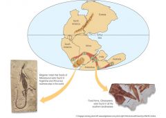
What evidence is there to support the theory of Pangaea? |
Similar fossils found across continents, alignment of similarly aged mountain ranges, shoreline fit of continental shelves, evidence of tropical plants in Antarctica |
|
|
What is the name of the single ocean at the time of Pangaea? |
Panthalassa |
|
|
What are the names of the Northern and Southern halves of Pangaea, and what modern-day land masses did they contain? |
Laurasia: North America and Eurasia Gondwanaland: South America, Africa, Antarctica, India, and Australia |
|
|
What does 'density stratified' mean? |
Distinct layers, where the deeper layers have higher density than the upper layers |
|
|
What are the two types of seismic 'body waves'? |
P-wave: Compressional wave S-wave: Shear wave |
|
|
What device is used to detect seismic activity? |
Seismograph |
|
|
How did data from an earthquake confirm Earth's layering? |
S-waves cannot pass through the liquid outer core. P-waves can pass through, but are refracted by the change in density. P-waves on the opposite side of the planet sped up through the solid inner core |
|
|
What is the name and numeric scale of the method used to describe the severity of an earthquake? |
Richter scale, and it is measured in logarithmic increments |
|
|
What is the depth and density of oceanic and continental crust? |
Oceanic: 4 km, 2.9 g/cm^3 Continental: 90 km, 2.7 g/cm^3 |
|
|
What is the depth of oceanic and continental Lithosphere? |
Oceanic: 4-70 km Continental: 90-200 km |
|
|
What is the depth and density of oceanic and continental Asthenosphere? |
Oceanic: 70-360 km Continental: 200-650 km Density: 3.3 g/cm^3 |
|
|
What is the density of the lower mantle? |
4.5 g/cm^3 |
|
|
What are the layers of Earth, in order? |
Crust, upper mantle (lithosphere and asthenosphere), lower mantle, outer core, inner core |
|
|
What process heats Earth's core? |
Radioactive decay, heating it to the temperature of the sun's surface |
|
|
Define conduction and convection |
Conduction: heat traveling through a substance Convection: circular motion of a fluid, caused by hot material rising, cooling, and returning to the heat source |
|
|
How do continents float? |
They displace a volume of the mantle equal in mass to the mass of the continent; this causes areas of higher elevation (mountain ranges) to sink further into the mantle |
|
|
What school of thought did James Hutton formalize in 1788, and what was its opposing principle founded by the Christian faith? |
Uniformitarianism: Earth is very old, and geological features have formed over a long time Catastrophism: Earth is the age described in the Bible, and all geological features are a result of the Great Flood |
|
|
What groundbreaking biological theory relied on uniformitarianism to be a viable mechanism?
|
Charles Darwin's theory of Natural Selection |
|
|
Who solidified Hutton's theories into a well-received piece of scientific literature that greatly contributed to geological and biological science? |
Charles Lyell, with Principles of Geology |
|
|
What evidence was used to support Wegener's theory in the mid 20th century? |
Violent geologic activity near ocean ridges, closer analysis of the Meteor echo soundings, radiometric dating of the oceanic crust, post WWII Navy echo soundings |
|
|
What force causes the continents to move? |
Convection currents in the lower mantle |
|
|
What geologic formation normally occurs at spreading centers in the crust? |
Lines of volcanoes, i.e the Pacific Ring of Fire |
|
|
Is the ocean at the edge of ocean basins (further from spreading centers) deeper or shallower than spreading centers? |
Deeper, because the cooler crust is higher in density and sinks into the asthenosphere |
|
|
Who is mainly accredited with the theory of plate tectonics? |
John Tuzo Wilson |
|
|
Are subduction zones found on the leading, or trailing edge of a continental plate? |
Leading edge, the trailing edge is a spreading center |
|
|
What is the term for adjacent plates moving laterally past eachother? |
Transform boundary |
|
|
What is the term for a plate sliding underneath an adjacent plate? |
Convergent boundary |
|
|
What is the term for two plates moving away from eachother? |
Divergent boundary |
|
|
What geological formation forms at divergent plate boundaries? |
Rift Valley |
|
|
Where is the only continental rift valley? |
Central Africa |
|
|
What large bodies of water were formed by the Central African rift? |
Red Sea and Gulf of Aden |
|
|
At what tectonic juncture are oceanic trenches located? |
Subduction zones |
|
|
Due to subduction, what land formation is created near oceanic trenches? |
Volcanic island chains |
|
|
What is the study of Earth's past magnetic field? |
Paleomagnetism |
|
|
What is the name of the device that measures residual magnetism? |
Magnetometer |
|
|
Why do transform plates form? |
The curvature of the Earth |
|
|
What land formation is created at the convergence of two continental plates of similar density? |
Mountain ranges |
|
|
How is residual magnetic field used to date rocks? |
Due to the Earth's occasional magnetic reversal, there are stripes of magnetic rock radiating from divergence zones, each from different time periods |
|
|
What is a terrane? |
Small piece of crust (island chain/microcontinent/oceanic plateau) that scrapes off the top of a subducting plate onto overriding continental plate |
|
|
What is the definition of bathymetry? |
Bathymetry: the study of seafloor topography |
|
|
How are echo sounders used to calculate depth? |
Depth(m) = Velocity (sound wave, m/s) x [Time (seconds) / 2] |
|
|
What two people used a combination of geology and artistry to depict the first accurate renditions of the ocean floor in 1977? |
Marie Tharp (artist) and Bruce Heezen (geologist) |
|
|
What is a continental margin? |
Continental margin: submerged outer edge of a continent Ends after the continental rise |
|
|
What is the difference between an active and passive continental margin? |
Active margins have high tectonic activity (Pacific Ring of Fire), whereas passive margins have little tectonic activity (Eastern US) |
|
|
Where is the continental shelf located? |
Shallow, submerged extension of a continent |
|
|
Where is the continental rise located? |
Between the continental slope and deep-ocean floor |
|
|
What does the floor of the continental slope consist of? |
Loose sediments, angled at about 4 degrees |
|
|
What forms submarine canyons in the continental shelf and slope? |
Turbidity currents |
|
|
What are oceanic ridges? |
Mountainous chains of young, basaltic rock forming from active spreading centers |
|
|
What are the two types of hydrothermic vents and what is the difference between them? |
White smokers: send out CaCO3 and silica Black smokers: send out H2S Both are found at ocean ridges, and are fueled by magma plumes |
|
|
Where is the littoral zone? |
Intertidal region, depending on tides it may be exposed to air |
|
|
What does the neritic zone encompass? |
Continental shelf |
|
|
How deep is the epipelagic zone and what is another term for it? |
Photic zone; 0-200 m |
|
|
What depth range is the mesopelagic zone, and what section of ocean floor is it associated with? |
Continental slope; 200-1000 m |
|
|
What depth range is the bathypelagic zone, and what section of ocean floor is it associated with? |
Continental slope; 1000-4000 m |
|
|
What depth range is the abyssopelagic zone, and what section of ocean floor is it associated with? |
Abyssal plain; 4000-6000 m |
|
|
What is the deepest oceanic zone, and what is its depth? |
Hadal zone: 6000-11,000 m |
|
|
What is another name for the deepest part of the Marianas trench? |
Challenger Deep |
|
|
What main two sections are the ocean floor divided into? |
Continental margin and deep-ocean basin |
|
|
What is the definition of sediment? |
Particlesof organic or inorganic matter that accumulate in a loose, unconsolidated formthat vary according to size, source, location and color |
|
|
What are the classifications and size ranges of gravel? |
Boulder: >256 mm Cobble: 64-256 mm Pebble: 4-64 mm Granule: 2-4 mm |
|
|
What are the classifications and size ranges of sand? |
Very course: 1-2 mm Course: 0.5-1 mm Medium: 0.25-0.5 mm Fine: 0.125-0.25 mm Very fine: 0.0625-0.125 mm |
|
|
What are the two classifications of mud? |
Coarser = silt, finer = clay |
|
|
What form of sediment comes from erosion, volcanic eruptions, and settled dust? |
Terrigenous; ~45% of ocean floor, dominant on continental margin |
|
|
What form of sediment is formed of calcium carbonate and silicon dioxide? |
Biogenous; ~55% of ocean floor, dominant on deep-ocean basins |
|
|
What form of sediment is formed from minerals dissolved by bacteria? |
Hydrogenous; <1% of ocean floor, i.e manganese nodules |
|
|
What form of sediment comes from comets, meteors and other debris from space? |
Cosmogenous; <1% of ocean floor, i.e tektite spheres |
|
|
What geologic formations have the highest concentration of sediments? |
River deltas; i.e Mississipi and Yangtze |
|
|
What processes distribute neritic sediments along the continental shelf? |
Currents, wave action and glacial deposits |
|
|
What is the process that converts sediment to rock? |
Lithification |
|
|
What process results in turbidites? |
An underwater 'avalanche' of sediment carried by its own density down the continental slope, onto the continental rise and abyssal plain |
|
|
What is the most easily transported terrigenous sediment, and why? |
Clay: its particles have the smallest diameter |
|
|
Why can calcareous oozes only exist at certain depths? |
Below the calcium carbonate compensation depth (CCD), there is a higher concentration of carbon dioxide, which results in the dissolution of calcium carbonate |
|
|
What type of biogenous sediment is predominant at depths below 4500 meters? |
Siliceous oozes, due to their slower rate of dissolution than calcareous oozes |
|
|
What is common among all hydrogenous sediments? |
Precipitation out of solution in seawater, in either manganese nodules, evaporites or oolite sands |
|
|
What is the systematic analysis of layered sediments? |
Stratigraphy |