![]()
![]()
![]()
Use LEFT and RIGHT arrow keys to navigate between flashcards;
Use UP and DOWN arrow keys to flip the card;
H to show hint;
A reads text to speech;
114 Cards in this Set
- Front
- Back
|
Geography |
the study of where things are found on Earth's surface and the reasons for the locations. |
|
|
Map |
a two dimensional or flat scale model of Earth's surface or a portion of it. |
|
|
cartography |
science of mapmaking |
|
|
two purposes maps serve: |
1. As a reference tool 2. As a communications tool |
|
|
Stick chart or stick map |
created by ancient people living on islands in the south Pacific. the map shows tides, island locations, currents, etc. |
|
|
Map by Al-Idrisi |
improved upon Ptolemy's design, creating a world map |
|
|
Eratostenes |
created one of the first world maps and first used the word geography |
|
|
Ptolemy |
created maps after Eratostenes that weren't improved upon for thousands of years because Europe was in a Dark Age |
|
|
Pei Xiu |
"father of chinese cartography" produced an elaborate map of china |
|
|
The Age of Exploration and Discovery |
revived mapmaking because people like Columbus and Magellan needed accurate maps. Marco Polo was a catalyst for this |
|
|
Martin Waldseemuller |
produced the first map with the label America |
|
|
Abraham Ortelius |
a flemish cartographer created the first modern atlas |
|
|
Bernhardus Varenus |
produced Geographia Generalis, stood for more than a century as the standard treatise on systematic geography |
|
|
Hurricane Katrina |
-one of the costliest disasters in US history -provided useful information on sustainability and inequality in New Orleans -showed how most of the poor and elderly could not be warned and evacuated in time which was why many of them suffered |
|
|
Map Scale |
refers to the relationship of a feature's size on the map to it's actual size on earth |
|
|
Ways Map Scale is presented: |
-ratio/fraction -written scale -graphic scale |
|
|
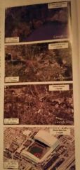
Top has smallest scale, bottom has largest |
|
|
Projection |
the scientific method of transferring locations on Earth's surface to a flat map |
|
|
Four Types of Distortion that can occur with maps: |
1. Shape can be distorted 2. Distance can be distorted 3. Relative Size of areas can be altered 4. Direction from one place to another |
|
|
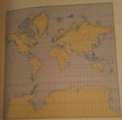
Equal Area Projections |
-relative size of landmasses is the same -distortion occurs closer to the poles, which has less impact because those areas are less inhabiteed |
|
|
Mercator Map Better around the equator Distortion near poles Pacific Ocean cut in half |
|
|
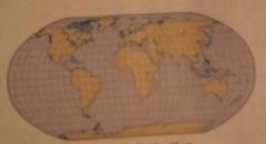
Robinson Projection Antartic easily visible Equal latitude lines Pacific ocean is sliced |
|
|
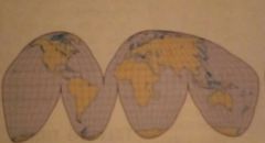
Goode Homolosine Projection Size relatively accurate Shows earths general cyrvature Measures some distances accurately Less stretching, more accuracy |
|
|
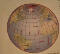
Geographic Grid |
set of imaginary arcs drawn in a grid pattern on Earth's surface |
|
|
Meridian |
drawn between the North and South Poles, known as longitude they go from 0 to 180 degrees |
|
|
prime meridian |
Passes through the Royal Observatory in Greenwich England at 0 degrees longitude |
|
|
parallel |
circle drawn around earth's surface that is parallel to the equator, also known as latitude |
|
|
Latitude: long ways 0°-90° Longitude: up and down 0°-180° |
|
|
Why was the prime meridian created at greenwich england? |
at the time england was the most powerful country and the international agreement was made for it to be that area |
|
|
Longitude Act |
enacted by the British Parliment in 1714 to whoever could figure out how to measure longitude John Harrison won the prize because he was the first to invent a clock that kept accurate time on a ship |
|
|
What plays an important role in telling time? |
longitude |
|
|
What is used for the timezones? |
longitude lines. Beginning in Greenwich England and heading to the right. Passing over the international date line makes you lose/gain a day though |
|
|
Geographic Information Science |
(GIScience) involves the development and analysis of data about Earth acquired trough satellite and other electronic information technologies |
|
|
Remote Sensing |
acquisition of data about Earth's surface from a satellite orbiting Earth or from other long distance methods |
|
|
Navteq and Atlas |
the two countries largely responsible for all of the data within navigation devices |
|
|
Global Positioning System |
the system that accurately determines the precise position of something on Earth |
|
|
US GPS contains three elements |
-satellites in predetermined locations -a receiver that can locate at least 4 satellites -tracking stations to monitor and control the satellites |
|
|
Geographic Information System |
a computer system that captures, stores, queries, analyzes and displays geographic data -allows data to be stored in layers for comparison |
|
|
Place |
a specific point on earth distinguished by a particular characteristic. Every place represents a unique location or position on Earth's surface |
|
|
location |
the position that something occupies on earth's surface |
|
|
three ways to identify location |
place name, site, and situation |
|
|
toponym |
name given to a place on earth |
|
|
site |
the physical character of a place includes: climate, water sources, topography, soil, vegetation, latitude, and elevation |
|
|
situation |
location of a place relative to other places |
|
|
region |
an area of Earth defined by one or more distinctive characteristics |
|
|
Two scales of region: |
1. Spanning political states (countries) 2. Constrained within one political state |
|
|
cultural landscape |
a combination of cultural features such as language and religion, economic features such as agriculture and industry and physical features such as climate and vegetation |
|
|
Paul Vidal de la Blache and Jean Brunhes |
initiated the cultural landscape approach, also called regional studies |
|
|
Formal Region |
also called a uniform region, is an area within which everyone shares in one or ore distinctive characteristics ex: U.S. - same currency and language |
|
|
Functional Region |
also called a nodal region, is an area organized around a node or focal point ex: Sports teams |
|
|
Vernacular Region |
also known as a perceptual region, is an area people believe exist as part of their cultural identity ex: American South |
|
|
mental map |
internal representation of a portion of Earth's surface, depicting what an individual knows about a place |
|
|
culture |
the body of customary beliefs, material traits, and social forms that together constitute the distinct tradition of a group of people |
|
|
Culture: What people care about |
language, religion, ethnicity, |
|
|
Culture: What people take care of |
material wealth-food, clothing, shelter |
|
|
scale |
relationship between the portion of earth being studied and earth as a whole |
|
|
globilization |
a force or process that involves the entire world and results in making something worldwide in scope |
|
|
housing bubble |
a rapid increase in the value of houses followed by a sharp decline in their value |
|
|
transnational corporations |
conducts research, operates factories, and sells products in many countries, not just where its headquarters and principal shareholders are located |
|
|
space |
referss to the physical gap or interval between two objects |
|
|
distribution |
the arrangement of a feature in space |
|
|
density |
frequency with which something occurs in a set space |
|
|
concentration |
the extent of a features spread over space |
|
|
two types of concentration |
1. Clustered - closely spaced together 2. Dispersed - relatively far apart |
|
|
pattern |
the geometric arrangement of objects in space |
|
|
Land Ordinance of 1785 |
the stystem of townships, ranges, and sections determined by the U.S. government after the revolutionary war |
|
|
behavioral geography |
branch of human geography that emphasizes the importance of understanding psychological basis for individual human actions |
|
|
humanistic geography |
a branch of human geography that emphasizes the different ways that individuals perceive their surrounding environment |
|
|
movement across space |
traditional roles and relationships affect how people move across space things that affect this: gender, ethnicity |
|
|
poststructuralist geography |
emphasizes the need to understand multiple perspectives regarding space |
|
|
Connection |
refers to relationships among people and objects across the barrier of space |
|
|
hearth |
a place where innovation originates |
|
|
diffusion |
the process by which a characteristic spreads across space from one place to anther over time |
|
|
relocation diffusion |
the spread of an idea through physical movement of people from one place to another |
|
|
expansion diffusion |
the spread of a feature from one place to another in an additive process |
|
|
hierarchical diffusion |
spread of an idea from persons or nodes of authority or power to other persons or places |
|
|
contagious diffusion |
the rapid widespread diffusion of a characteristic through a population |
|
|
stimulus diffusion |
the spread of an underlying principle even though a characteristic itself apparently fails to diffuse |
|
|
distance decay |
contact diminishes with increasing distance and eventually fades |
|
|
space-time compression |
reduction in time it takes for something to reach another place |
|
|
network |
a chain of communication that connects places |
|
|
uneven development |
the increasing gap in economic conditions between regions in the core and periphery that results from the globalization of the economy |
|
|
resource |
substance in the environment that is useful to people economically and technologically feasible to access and socially acceptable to use |
|
|
renewable resource |
produced in nature more rapidly than it is consumed by humans |
|
|
nonrenewable resource |
produced in nature more slowly than it is consumed by humans |
|
|
sstainability |
the use of earth's renewable and nonrenewable natural resources in ways that ensure resource availability in the future |
|
|
Our Common Future, also known as the Bruntland Report |
from the UN it argues that sustainability can be achieved only by bringing together environmental protection, economic growth, and social equity |
|
|
conservation |
the sustainable use and management of earth's natural resources to meet human needs such as food, medicine, and rereation |
|
|
preservation |
the maintenance of resources in their present condition with as little human impact as possible |
|
|
the economy pillar |
natural resources acquire monetary value, depending on the supply and demand |
|
|
the environmental pillar |
conservation/preservation |
|
|
the society pillar |
consumer choices support sustainability when people embrace it as a value |
|
|
World Wildlife Fund |
argues that humans are currently already using the full amount of "biologically productive" land on Earth |
|
|
"biologically productive" land |
land required to produce the resources currently consumed and handle the wastes currently generated y the worlds 7 billion people at current levels of technology |
|
|
biotic system |
composed of living organisms |
|
|
abiotic |
nonliving or inorganic matter |
|
|
atmosphere |
thin layer of gases surrounding earth |
|
|
lithosphere |
earth's crust and a portion of upper mantle directly below the crust |
|
|
biosphere |
all living organisms on Earth |
|
|
climate |
long term average weather condition at a particular location
|
|
|
ecosystem |
group of living organisms and the abiotic spheres with which they interact |
|
|
ecology |
the scientific study of ecosystems |
|
|
erosion |
occurs when soil washes away or blows away in wind |
|
|
depletion of nutrients |
when plants withdraw more nutrients than can be naturally replaced |
|
|
cultural ecology |
the geographic study of human-environment relationships |
|
|
environmental determinism |
theory by Alexander von Humboldt and Carl Ritter that te physical envronment caused social development |
|
|
Friedrich Ratzel and Ellen Churchill Semp |
theorized that geography was the study of influences of the natural environment on people |
|
|
Ellsworth Huntington |
argued climate was a major determinant of civilization |
|
|
possiblism |
the physical environment may limit some human actions but people have the ability to adjust to their environment |
|
|
polder |
a piece of land that is created by draining water from an area |
|
|
"God made Earth, but the Dutch made the Netherlands" |
modified their country with polders and dikes to create more land and keep it from being underwater |
|
|
Zuider Zee |
a dike constructed caused the zuider zee to become a freshwater lake |
|
|
Delta Plan |
called for construction of several dams to close off waterways |
|
|
"god made the world in six days and the army corps of engineers has been tinkering with it ever since" |
the army corps straightened a few miles of Kissimmee River causing some of the everglades to be lost |