![]()
![]()
![]()
Use LEFT and RIGHT arrow keys to navigate between flashcards;
Use UP and DOWN arrow keys to flip the card;
H to show hint;
A reads text to speech;
348 Cards in this Set
- Front
- Back
|
Stress ***
|
the amount of force divided by the area on which the force is applied
|
|
|
Strain
|
change in shape or volume of a body as a result of stress
|
|
|
Orogenesis
|
the formation of mountains or the time period during which tectonic activity causes deformation and forms mountains.
|
|
|
Differential stress
|
a condition with unequal stresses from different directions.
|
|
|
Fluid Pressure
|
pressure from water in pore spaces that pushes outward in all directions and opposes the inward-directed confining pressure on the rockacts to decrease the confining pressure
|
|
|
Shear Stress |
type of differential stress that occurs when stresses on the edge of a mass are applied in opposite directions
|
|
|
Tension |

the type of differential stress where stress is directed outward, pulling the material
|
|
|
Compression |
the type of differential stress that occurs when forces push in on a rock
|
|
|
Joint ***
|
a fracture in rock where the rock has been pulled apart slightly, without significant displacement parallel to the fracture
|
|
|
Fault *** |
a fracture along which the adjacent rock surfaces are displaced parallel to the fracture. Sliding has occured
|
|
|
Fold
|
creases in rock formed by compressive stress
|
|
|
Vein
|
a generally tabular accumulation of minerals that filled a fracture or other discontinuity in a rock..formed by precipitation of material from fluids, especially hydrothermal fluids
|
|
|
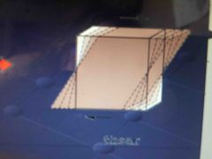
Strike |
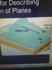
the direction of a horizontal line on an inclined surface
|
|
|
Dip |
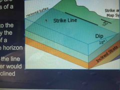
the angle that a layer or structural surface makes with the horizontal, measured perpendicular strike
|
|
|
Dome
|
a circular or elliptical anticlinal structure in which the rocks dip gently away from the center in all directions
|
|
|
Basin
|
a low lying area or an area in which sediments accumulate with no surface outlet, dipping towards the center to form a bowl shape
|
|
|
Limb |
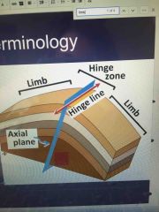
the planar or less curved parts of a fold on either side of the hinge
|
|
|
Hinge
|
the part of a fold that is most sharply curved
|
|
|
*What is orogenesis, what happens during orogenesis?
|
Orogensis is mountain building. During it rocks undergo DEFORMATION, when they are squashed, stretched bent or broken |
|
|
*What is deformation and what causes it? |
Deformation is the change in configuration of a body of material in response to stretching, squeezing, shearing into a new configuration
Stresses cause |
|
|
Understand what stress and strain are, how stress can cause strain. Be sure to know the differences between stress and strain.
|
Stress is the force applied to a surface per unit area. strain is the change in shape of a material from its original shape to a new shape, caused by stress |
|
|
What are the different types of stress? What about strain?
|
Different types of stress- confining pressure, differential stress (compression-rock is squeezed, tension-rock is pulled apart, shear stress-1 side of a rock is pushed sideways past another), fluid pressure (counteracts stress). Different types of strain: stretching/elongation- rock layer becomes longer in direction of interest, shortening/contraction-rock layer becomes shorter in direction of interest, shear strain (movement of one part of the rock body past another) |
|
|
Understand the transition from brittle to ductile behavior in rocks, and how burial and increasing temperature and pressure influence mechanical behavior
|
Brittle rocks break into more than two pieces, while Ductile rocks change shape. High pressure, hot rocks are ductile, while low pressure cold rocks are brittle. Rocks with slow deformation rate are ductile. Halite is ductile, granite is brittle. At first, rocks get stronger (more ductile) with depth but then they get weaker deep in the crust. composition- halite = ductile, granite= brittle |
|
|
Know the components of a fault, be able to describe it’s architecture
|
A fault is composed of a fault zone, a hanging wall (where a miners head would be), and the footwall (where a miners feet would be. |
|
|
joints
|
fracture in rock, crack where rock pulled apart.. formed by burial and tectonic forces, or cooling and contraction or unloading
|
|
|
tip of fracture
|
very unstable, creates zone of plastic deformation
|
|
|
fault zone
|
an area which there are several closely spaced faults.
|
|
|
How do you describe the orientation of a plane? What is strike and dip?
|
strike- the line formed by the intersection of a plane and the horizon dip- steepest angle of descent between the plane and the horizon, 90 degrees from strike, direction that water flows down slope |
|
|
What is Dip slip vs. Strike slip? How is a normal fault different from a reverse fault or a strike slip fault? What sort of strain results from different faults?
|
dip slip: sliding occurs up or down the slope of the fault, up or down dip direction strike slip: one block slides past the other parallel to the line of strike, fault moving in direction of strike, horizontal oblique slip: faults move diagonally across the fault plane (mix or strike and dip) |
|
|
Understand Fold Terminology-Limb, Hinge, ect.
|
folds- curved rock layers, type of DUCTILE deformation hinge zone:section of the fold with the tightest curvature limb: planar or less curves sections of a fold anticlines: folds with and arch like shape (A) Synclines: folds with a trough shape, (U or V) |
|
|
which is the best description of what the lithosphere contains?
|
continental and oceanic crust |
|
|
Which of the Earth’s layers is the thinnest?
|
oceanic |
|
|
What is the rock cycle?
|
the process that describes the formation and destruction of rocks |
|
|
Which layer in the earth is similar to the composition of granite?
|
continental crust |
|
|
What does seismic energy tell us about the earth’s interior?
|
tells us which layers of the earth are solid and which are liquid |
|
|
Which is NOT a possibility for why a region in high elevation than adjacent regions?
|
the crust is more dense (it can be because the lithosphere is hotter, one region is continental crust and the rest are oceanic, or how the outer core differs from the inner core, and how the upper mantle differs from the lower mantle |
|
|
The principle of isotasy refers to:
|
the relationship between regional elevations and thickness of crust |
|
|
Continental Collision
|
is a phenomenon of the plate tectonics of Earth that occurs at convergent boundaries.Regions where this process occurs are known as subduction zones.
|
|
|
Hotspots ***
|
is a location on the Earth's surface that has experienced active volcanism for a long period of time.
|
|
|
Craton ***
|
the old, low density, stable part of continents, usually rocks found in center of continents, lowest density of continental crust. the stable interior portion of a continent
|
|
|
Oceanic trench
|
a type of thin, mafic crust that underlies the ocean basins.
|
|
|
Accretionary Prism
|
is formed from sediments that are accreted onto the non-subducting tectonic plate at a convergent plate boundary. accretionary prism forms along the subduction zone
|
|
|
Geologic Terrane
|
as distinct from the more general topographic term 'terrain', is a crustal block or fragment that is typically bounded by faults and that has a geologic genesis distinct from those of surrounding areas.
|
|
|
What do normal, strike slip, and reverse faults do to the crust? Which faults cause extension? What about shortening?
|
normal faults extend and sometimes thin the crust reverse faults shorten crust |
|
|
What is continental accretion?
|
material that is too buoyant to subduct is attached to the continent process through which material is added to continents, occurs during mountain building, subduction and collision, also when erosion causes deposition of new sediments into plate margins |
|
|
How do continents grow?
|
Through continental accretion of exotic terranes and can become thicker or thinner over time. |
|
|
Folds are ductile, faults are brittle.
|
true
|
|
|
Where does brittle deformation take place within the earth? What about ductile deformation?.
|
brittle near surface, ductile within earth (mantle) because there it’s hotter and there’s more pressure |
|
|
How does the strength of the earth vary with depth? Why does this change?
|
At first, rocks get progressively stronger (from brittle to more ductile) with depth but then they get weaker deep in the crust. This changes because of differences in pressure and temperature within the earth. |
|
|
***What controls regional elevation? Understand the different ways mountain belts are created and regional elevation is built up
|
Regional elevation is controlled by continents become thicker or thinner over time. Regional elevation is built up from if the crust is shortened, if more material is added through igneous processes, and heating. Mountain belts are created by subduction, continental collision, and mantle upwellings. |
|
|
***Know how elevation is decreased
|
normal faulting stretch and thins the crust. Erosion can move material from thick/high areas to thin/low areas. when rocks cool they become thinner`` crustal thinning/regional lows are caused by extension of the lithosphere |
|
|
Where do you find mountain belts? What are the plate tectonic settings? What processes occur in different tectonic settings (think accretion or addition of magma)
|
Mountain belts are found along convergent plate boundaries. In an oceanic subduction zone, magma and material are added by accretion, thickening the crust. As slab pull pulls the subduction plate down into the subduction zone, an oceanic trench forms. Environments- subduction, continental collision, mantle upwellings...Subduction zone occurs, continental collision and mantel upwelling. |
|
|
Subduction of Oceanic Crust
|
crust thickened by addition of magma, also thickened by shortening & material also added by accretion. As the slab-pull force pulls the subjecting plate down into the subduction zone, OCEANIC trench forms. Horizontal compression leads to strain and formation of thrust faults. Accretionary prism forms along subduction zone. Magma rises from melting of sub ducting slab and is emplaces in the plate
|
|
|
Continental Collision
|
high elevation bc one continent tries to subduct under the other, this cant happen so the they become sutured and thickness of crust is doubled. Results in significant accretion. The interiors of collisional mountain belts = significant metamorphism
thrust fault thicken the crust, even behind collision zone, stresses can be very high, causes a lot of strain |
|
|
Mantle Upwelling
|
lead to regional heights, usually prelude to rifting, occur at hot spots
What is an exotic terrane and how does this build new continental crust? How does this influence continental formation? An exotic terrane is a new rock that is added to a region by accretion that comes from another place. |
|
|
What is a hotspot?
|
volcanic areas above rising mantle plumes, the mantle convects, when it rises hot spot can form. eg Hawaii. Hotspots around yellowstone |
|
|
Understand how a rift forms and how this is different from a hot spot (it is different)
|
A rift forms from lithospheric stretching . As opposed to a hotspot, rifts form when the mantle upwells as a result of crustal thinning, not convection. hot spots CAN evolve into rifts. Pieces of material are added to continents through accretion and are pulled away during rifting |
|
|
***What can change local elevation?
|
not every mountain is part of a regional mountain belt, elevation highs can be caused by a variety of factors: thrust, normal folding can create local mountains, biggest impact on erosion |
|
|
How does erosion cause local mountains?
|
erosion is the most important factor in controlling topography,break off excess material/rock helping to eventually form local mountains. Resistant rock forms hills, softer rock forms valleys from erosion. |
|
|
rift basin xxx
|
sediments deposited into low areas as lithosphere is pulled apart.Caused by continental rifting and normal faulting
|
|
|
Types of Rift Basins: xxx
|
continental rifting and normal faulting can cause the development of basins, small ones occur at each normal fault
|
|
|
Flexural Basin xxx
|
lithosphere flexes bc of mass of mountains, sediments fill gaps
|
|
|
Types of Flexural Basin xxx
|
Foreland basins occur when lithosphere is flexed bu the weight of a mountain belt
Passive margins occur when a continental plate sits next to an oceanic plate. as sediment piles up at this boundary, the plates flex allowing for more room |
|
|
Main reason why the hypothesis of continental drift was not widely accepted was:
|
there was no mechanism to move continents through the oceanic crust |
|
|
What is associated with reversed magnetic polarity?
|
a compass needle would point south |
|
|
xxx There are two major types of rock textures, crystalline and clastic. What is the difference?
|
crystalline rocks are made from interlocking crystals that grew together, and clastic rocks are made of pieces of other rocks |
|
|
The force that is most important in driving plate tectonics is:
|
ridge push, slap pull, upwelling mantle (hotspots) |
|
|
A mineral must have..
|
an ordered internal structure (NOT cleavage, shiny crystals, silicate tetrahedron) |
|
|
Epicenter
|
the point on Earth’s surface directly bove where an earthquake occurs
|
|
|
Hypocenter ***
|
the place where an earthquake is generated
|
|
|
Elastic Strain
|
the ability of a material to strain a small amount and then return to its original shape when the stress is decreased
|
|
|
P-Wave (Primary Wave) ***
|
a seismic body wave that involves particle motion, consisting of alternating compression and expansion, in the direction of propagation.
|
|
|
Seismometer
|
sensitive digital instruments that are able to precisely detect a wide range of earthquakes
|
|
|
What is an Earthquake? What are seismic waves?
|
An earthquake is a release of seismic energy in the earth. Seismic waves release mechanical seismic energy. |
|
|
Earthquake connection to plate tectonics
|
caused by normal faults, reverse & thrust faults, strike slip faultrelease of seismic energy in the earth, usually this happens when stored energy rocks is released when the rocks break. Most caused by the bild up of spress alond a fault, resulting in a rupture and slip.Seismic energy is a type of mechanical energy that is released in waves, they radiate outward from hypocenter |
|
|
How do earthquakes cause tsunamis?
|
Tsunami’s form from fault related earthquakes on the seafloor. Fault movement uplifts or down drops the seafloor. |
|
|
What are the different ways that seismic waves can be generated? Which way produces the biggest earthquakes?
|
Seismic waves can be generated by normal/reverse/ strike slip faults, volcanoes, landslides and explosions. The biggest earthquakes are produced by the buildup of stress along a fault. |
|
|
What elastic rebound? Give a real life example?
|
stress applied to an object transfers energy to it (why earthquakes occur). If elastic strain energy overcomes the strength of a material, it breaks and rebounds to its original shape. Stress increase causes elastic strain to increase. A real life example can be seen with a rubber band. FAULT- rock breaks when stress overcomes strength |
|
|
Explain what happens to rock before, during, and after an earthquake occurs in terms of stress and strain
|
stress increase causes elastic strain to increase. Eventually material ruptures (earthquake). Before- stress increases, elastic strain (Rising part of graph) During- fault slips causes earthquakes (top curve of graph) After- stress drops, post-slip recovery of elastic strain & cycle starts again. (bottom/ end of graph) |
|
|
Where do earthquakes start?
|
starts as small patch below surface @ hypocenter (focus), migrates out, ruptures surface (fault scarp), fault scarp lengthens. |
|
|
Understand the systems that produce earthquakes (MOR, Subduction, Collision). Where do these earthquakes occur (how deep and where in the plate)? How big are the earthquakes?
|
Subduction zones produce the largest earthquakes and mid ocean ridges produce small earthquakes. |
|
|
How are earthquakes monitored? What equipment is used? What does it measure?
|
Seismometers measure seismic waves, record amount of shaking that occurs during an earthquake. They are placed in the ground and measure vibrations. One could also triangulate the epicenter to estimate distance, or measure s-wave amplitude. |
|
|
What are the different types of seismic waves? How are they different?
|
Surface waves- horizontal surface wave shears material side to side vertical surface wave shears material up and down only travel along surface of earth Body waves- Primary body wave (P-Wave) compresses and expand material, FASTEST. Compressional, push atoms closer together in the direction they’re moving. Secondary Body Wave (S-Wave) shears material, FASTER, shear material up & down or side to side body waves move through EARTH |
|
|
Why can’t s-waves move through liquid?
|
S-Waves depend on a resistance to shear, which doesn’t exist in a liquid |
|
|
Understand wave refraction and reflection-be able to figure out which way a wave will bend at a boundary
|
A seismic wave bends as it travels through faster or slower material. From fast to slow, it undergoes a steep refraction, from slow to fast, it’s much more subtle of a change (not steep), and when rising from fast to slow, it continues on the same path that it was initially on. |
|
|
What do seismic waves tell us about the earth’s interior?
|
Seismic waves tell us about the density of certain parts of earth’s interior. Based off of the way they refract, we can figure out if they’re travelling fast (through less dense material) or slow (through more dense material) |
|
|
Which of the following is true about when earthquakes occur?
|
deep and intermediate-depth earthquakes occur near subduction zones |
|
|
Which is a characteristic of p-waves?
|
they compress and then expand the rock in the direction the waves travel |
|
|
When do rocks along a fault have the highest amount of stress and stored elastic strain?
|
right before an earthquake |
|
|
What controls local mountains and valleys?
|
rock strength and erosion |
|
|
What is a craton?
|
the old, low density section of a continent |
|
|
Angular Unconformity ***
|
an unconformity (ancient erosion surface) in which the older, underlying strata dip more steeply or at a different angle than the younger, overlying strata. Created by deposition into normal layers, then uplift and tilting of those layers, erosion of that tilted group of layers, and then deposition onto the tilted eroded rock.
|
|
|
Nonconformity
|
suggests that a period of long‐term uplift, weathering, and erosion occurred to expose the older, deeper rock at the surface before it was finally buried by the younger rocks above it. A nonconformity is the old erosional surface on the underlying rock.
|
|
|
Disconformity
|
an unconformity in which the bedding planes above and below the break are essentially parallel, but the unconformity surface records erosion or some other interruption in the deposition of layers
|
|
|
Isotope xxx
|
one or two or more species of the same chemical element but differing from one another by having a different number of neurons
|
|
|
Radioactive Decay xxx
|
the spontaneous disintegration and emission of particles from an unstable atom
|
|
|
Half-life xxx
|
in radioactive decay, refers to the time it takes for half of the parent atoms to decay into a daughter product
|
|
|
Relative vs. Absolute Dating
|
Relative dating refers to the order in which events happen, while absolute dating refers to the specific time in which an event took place (the age of events). |
|
|
Know the principles of geology and relative dating and what they mean
|
The principle of inclusion refers to how younger rock can contain pieces of older rocks. The principle of altered contacts refers to the fact that younger rocks can cause changes along their margins. Also remember the principles of uniformitarianism, superposition, cross-cutting relationships, and horizontality. Be able to determine relative age from cross cutting relationships |
|
|
What are the different types of unconformities?
|
A nonconformity separates a layered surface from a non layered surface (a non layered rock uplifted and eroded with igneous rocks deposited on top). An angular unconformity refers to the contact that separates a younger gently dipping rock unit from underlying rocks that are tilted layered rocks. A disconformity separates two layered sections. |
|
|
How are fossils preserved? ****
|
by shells, bones, replacements, casts, molds, impressions and amber. |
|
|
How can we use fossils to determine age of rock?
|
The rock record. Fossil rich sedimentary rocks reveal patterns of evolution and extinction |
|
|
What is stratigraphic correlation? Be able to do a basic correlation
|
Tracing layers of rock from place to place. Can be lithologic (based on rock), chemical (based on chemical composition), or time (based on age) |
|
|
What is an isotope?
|
An atom with same number of protons, but a different number of neutrons. |
|
|
Be able to use half-life and parent and daughter isotope information to determine age. (Basic equation will be given)
|
(Starting amount) x ½^(# of half lives)=(Ending amount) (Time for each half life) x (# of half lives |
|
|
What can radiometric dating determine?
|
The age of the rock |
|
|
What assumptions are used for radiometric dating?
|
Rock/mineral composition has not been altered, No daughters present when rock formed |
|
|
A transgressive sequence is characterized as:
|
sea level rise, as evidenced by a pattern of rocks that show increasingly deeper water and depositional environments with time |
|
|
Which of the following matches a sedimentary rock with a possible metamorphic equivalent?
|
sandstone-quartzite shale-gneiss limestone-marble shale-schist |
|
|
What type of rock is in a coral reef? ***
|
limestone |
|
|
Clastic sedimentary rocks are classified primarily on the basis of?
|
clast or sediment size |
|
|
Sorting of rocks describes?
|
the size range of clasts in sediment |
|
|
Shale is metamorphosed into three rocks branded gneiss, a rock with small mica crystals with shiny aspect, and a very shiny rock with large mica crystals and a dull slate with cleavage. Order?
|
dull slate, rock with small mica, very shiny rock with large crystals, banded gneiss |
|
|
Hydrosphere
|
is the liquid water component of the Earth. It includes the oceans, seas, lakes, ponds, rivers and streams.
|
|
|
Hydrologic Cycle
|
the sequence of conditions through which water passes from vapor in the atmosphere through precipitation upon land or water surfaces and ultimately back into the atmosphere as a result of evaporation and transpiration
|
|
|
Drainage Basin
|
an area in which all drainages merge into a single stream or other body of water
|
|
|
Discharge xxx
|
the volume of water flowing through some stretch of river or stream per unit of time
|
|
|
Hydrograph xxx
|
a graph showing the change in the amount of flowing water
|
|
|
Sediment Capacity xxx
|
total amount of sediment that a stream is able to transport
|
|
|
Suspended Load xxx
|
fine particles, generally clay and silt, that are carried suspended in moving water
|
|
|
Bed Load
|
material, commonly sand and larger, that is transported along the bed of a river.
|
|
|
Saltation
|
transport of sediment in which particles are moved in a series of short, intermittent bounces on a bottom surface.
|
|
|
Traction ****
|
the process by which particles roll, slide, or otherwise move on the surface, by such transport agents as streams, wind or waves.
|
|
|
Thalweg
|
a line drawn to join the lowest points along the entire length of a stream bed or valley in its downward slope, defining its deepest channel.
|
|
|
Levee xxx
|
a long, low ridge of sediment deposited by a stream next to the channel.. some levees are built by humans to keep floodwaters from spilling onto a floodplain.
|
|
|
River Delta xxx
|
a landform that forms at the mouth of a river, where the river flows into an ocean, sea, estuary, lake, or reservoir. Deltas form from deposition of sediment carried by a river as the flow leaves its mouth
|
|
|
What are the different types of drainage patterns? What causes these differences?
|
Dendritic, Radial, and structurally controlled. Discharge over time/erosion cause these differences. |
|
|
What watershed/drainage basin do you live in? What river does all of the rain in Geneseeo
|
drain into?
We are in the Genesee River Basin, and all the Geneseo rain drains into the Genesee River. |
|
|
What is discharge and how do we measure discharge?
|
Discharge is the amount of water flowing through a channel over time. We measure it by multiplying channel width x depth x velocity of water. Understand how the different components of rivers change downstream (channel size, discharge, sediment load, maximum grain size) |
|
|
What causes erosion, transportation, and deposition? What is the difference between erosion and weathering?
|
Weathering happens, then does erosion loosening up sediments that are then carried/transported downstream and eventually deposited. |
|
|
Know how transportation and deposition change with current velocity and sediment size
|
A suspended load results in sediments floating in water. Soluble Ions are dissolved and carried by moving water. Saltation is when sand grains roll and bounce along. Traction refers to when cobbles and boulders roll and slide during high flows. Bed load is the material moving on the riverbed. At high velocity, sand and smaller particles are carried in suspension. At moderate velocity, silt and clay remain suspended but sand moves as bed load, and at the lowest possible velocity, sand dropped but silt and clay remained in suspension- all of this summarized in Hjulstrom plot. |
|
|
Understand the difference between laminar and turbulent flow
|
At high velocities, flow becomes chaotic and is turbulent, forming a swirl called an eddy. Viscosity and surface tension act to keep water smooth and slow moving in a laminar flow. |
|
|
How do meanders form?
|
As water erodes in some sections of a straight channel and deposits in other sections, curves called meanders form. |
|
|
What is the thalweg? Where is the thalweg going to be around a meander?
|
The fastest section of the river is the thalweg. Around a meander, the thalweg is the lowest/deepest point of a meander and near the outside bend. |
|
|
What is the difference between a braided stream and a meandering stream?
|
A braided stream is a network of interweaving wide/shallow channels, fluctuating discharge, steep gradient and occur in mountain settings and glacial environments. A meandering stream is very curved and highly sinuous. |
|
|
How do natural levees form?
|
Flooding. |
|
|
How do streams erode? Understand how this leads to terrace development
|
Streams erode from increased discharge and reduced sediment supply. Also, when erosion increases, incision (a river cuts down through its base) happens, leading to terrace development. |
|
|
Know where streams deposit sediment and understand the conditions that lead to this deposition.
|
Climate change and uplift can affect sediment supply and discharge. Streams deposit sediments at a delta when there’s decreased discharge and increased sediment supply. |
|
|
What is a flood?
|
When water overflows channel and spills onto floodplain. |
|
|
What are deltas? What happens at deltas? How do waves and tides change the shape of deltas?
|
The shape of the delta depends on the energy of the system (will be larger if more energy). Deltas are a landform that forms at the mouth of a river, where the river flows into an ocean, sea, estuary, lake, or reservoir. There, sediment is deposited. |
|
|
What causes a natural levee to form?
|
erosion |
|
|
A polonium 210 isotope decays to Polonium 206 and has a half life of 138 days. If a russian spy is injected with 10,000 atoms of polonium 210 how many parent atoms would be left after 690 days?
|
312.5 days |
|
|
What type of sediment transportation within rivers leads to bouncing and rolling of sand grains?
|
saltation |
|
|
How do we measure a stream’s discharge?
|
the cross sectional area of the stream multiplied by water elocity |
|
|
If a rock is subjected to differential stress, then it means:
|
the amount of stress in greater in some directions than in others |
|
|
If a sample has 225 atoms of a parent isotope and 675 atoms of a daughter isotope how many half lives have passed?
|
2 |
|
|
How does the strength of continental crust vary with depth?
|
at first, rocks become stronger with depth but then they get weaker deep in the crust |
|
|
What is a point bar?
|
a depositional feature feature caused by slow moving water on the inside of a meander |
|
|
Sonar
|
using sound waves to determine the distance to reflecting objects, especially depth of the seafloor or a lake bottom
|
|
|
Pillow Basalt
|
a basaltic lava flow that includes pillow structures
|
|
|
Black Smoker
|
hydrothermal vents on the sefloor in which hot water from within the rock jets out into cold seawater and forms a cloud of minerals, especially those rich in sulfur
|
|
|
Divergence
|
a plate-tectonic boundary in which two plates move apart (diverge) relative to one another
|
|
|
Decompression Melting
|
melting of rock or other material due to a decrease in pressure
|
|
|
What sort of boundaries form new oceans?
|
divergent boundaries |
|
|
How do oceans form? Understand the evolution from a Continental Rift to an ocean
|
plate tectonics and convection |
|
|
What types of features do we see in continental rifts? What about around Mid Ocean Ridges?
|
Divergent boundaries move faults that create a rift zone. Loss of pressure causes decompression melting of the mantle at mid ocean ridges. The hot upper mantle turns to liquid when released forming new oceanic crust. |
|
|
How are oceans explored? How do we make maps of oceans if we have very limited subsurface exploration and direct mapping?
|
Oceans are explored with the use of sonar (measures travel time of sound waves as they bounce off the seafloor), seismic reflection (measure travel time of sound off different layers of rock), sampling floor materials, drilling vessels and submersibles. |
|
|
Tides
|
the rise and fall of sea levels due to the gravitational pull of the Moon and Sun.
Spring Tides-when the difference between high tide and low tide is greatest. Occurs twice a month, at full moon and new moon. |
|
|
Neap Tide
|
when the difference between low tide and high tide is the least. It occurs twice a month at the first quarter moon and third quarter moon.
|
|
|
Trough
|
the lowest point of a wave.
|
|
|
Wave Base
|
the point in which underneath this there is no wave action.
|
|
|
Swash
|
the layer of water that washes up on a shore once a wave has broken.
|
|
|
Backwash
|
Backwards flow of water, when the water moves out after it washes up on shore.
|
|
|
Longshore Transport
|
the transportation of sediments along a coast at an angle to the shoreline, which is dependent on prevailing wind direction, swash and backwash
|
|
|
What causes tides? Why are there two tides every day? What is the difference between a spring tide and a neap tide?
|
Tides are caused by forces of gravity exerted by the Moon, Sun, and rotation of Earth. A neap tide occurs twice a month, at the first quarter moon and third quarter moon. Neap tides are when the difference between the high tide and low tide is the least. A spring tide also occurs twice a month,at the full moon and new moon, and it is when the difference between high tide and low tide is the greatest. |
|
|
What causes extreme tidal ranges? What about areas with very little tide?
|
The size of the bay is what causes the extreme tidal range. The Bay of Fundy has the most extreme tidal ranges in the world. Extreme tidal ranges cause wave action over a wide range of elevation. |
|
|
What is a wave (ocean)? What causes waves? Understand how particles of water move as waves propagate across water
|
Waves are caused by wind hitting the surface of the ocean. Particles of water move in circular motions in waves. Deeper in the water there is less motion. |
|
|
What are the different parts of a wave? What is wave base and how is it calculated?
|
Crests and troughs are different parts of waves. Wave base is the level in the water in which underneath it there is no wave action. The distance between wave base and the wave is ½ the distance of wavelength. |
|
|
What happens when a wave breaks on the beach?
|
When waves break on a beach, waves slow down, wave height increases, wave length decreases, and wave height increases. |
|
|
What is wave refraction? What causes it?
|
Wave refraction is when waves bend as they hit the shore. This happens because waves slow down as there is more friction with the shore. |
|
|
How is sediment moved around on a beach? What determines if beaches will be depositional or erosional? How do storms, rivers, reefs, currents, and erosion on land impact beaches?
|
Beaches are depositional when there is a lot of available sediment, hen sea level is falling, and when the beach has a gentle gradient. Beaches are erosional when sea level is rising, there is not a lot of available sediment, and when the shore is steep or there is no beach face. |
|
|
What is longshore transport and how does it happen?
|
ocean current that moves parallel to shore. It is caused by large swells sweeping into the shoreline at an angle and pushing water down the length of the beach in one direction. |
|
|
What are some coastal features carved by erosion? How do the form?
|
Sea arches, sea cliffs, pinnacles and wave-cut platforms. |
|
|
What are some coastal features formed by deposition?
|
Spits, barrier islands, baymouth barrier, sandbar. |
|
|
What do people do to fight coastal erosion?
|
Building jetties, seawalls, beach nourishment and breakwaters. |
|
|
Insolation
|
the quantity of solar radiation falling upon a body or planet, esp per unit
|
|
|
Solar Irradiance
|
a measure of the irradiance (power per unit area on the Earth’s surface) produced by the Sun in the form of electromagnetic radiation, shich is perceived by humans as sunlight
|
|
|
Albedo ***
|
the proportion of the incident light or radiation that is reflected by a surface, typically that of a planet or moon. high albedo -lots of reflection ... low albedo absorption
|
|
|
Convection **
|
the movement caused within a fluid by the tendency of hotter and therefore less dense material to rise and colder, denser material to sink under the influence of gravity, which consequently results in transfer of heat.
|
|
|
Coriolis Effect ***
|
an effect whereby a mass moving in a rotating system experiences a force acting perpendicular to the direction of motion and to the axis of rotation. on the earth the effect tends to deflect moving objects to the righ in the northern hemisphere and to the left in the southern.
|
|
|
Ocean Gyre
** |
a large system of cirular ocean currents formed by global wind patterns and forces created by Earth’s rotation
|
|
|
Eckman Transport ***
|
is the net motion of fluid as the result of a balance between Goriolis and turbulent drag forces. in the picture above, the wind blowing North creates a surface stress.
|
|
|
Thermohaline circulation ***
|
caused by temperature and desity differences and is deep water current. mostly deep-water ocean current driven by density differences that are caused by variations in tem and salinity
|
|
|
What are the major components of the atmosphere? How does the atmosphere vary with altitude?
|
from bottom to top: troposphere, stratosphere, mesosphere, thermosphere Atmospheric pressure decreases with altitude |
|
|
How does earth’s rotation around the sun and earth’s axis impact seasons? **
|
max tilt: warmer summers near poles, more melting and less glaciation min tilt: cooler summers, less melting and more glaciers |
|
|
What is Albedo and how can it be changed? What effects do seasons have on Albedo? ***
|
albedo is the ratio of reflected sunlight to incident sunlight. High albedo = lots of reflection, Low albedo = lots of absorption. It is highly dependent on surface of the earth, ice has a high albedo. Lower albedo in the summer than the winter |
|
|
How do atmospheric circulation cells form? What effect does the Coriolis Effect have on circulation cells?
|
the atmosphere transfers heat from low to high latitudes via circulation due to albedo, incoming solar radiation at different angles and earth’s orientation. they all cause a heat transport gradient because there is uneven heating convection of earth’s atmosphere develops. convection acts to move heat around the ear, cold parts become warmer and warm parts become colder Hadley cell: hot air rises and spreads out, then polar cell air cools and falls |
|
|
Be able to understand how the Coriolis Effect deflects wind and water in the Northern and Southern Hemispheres, be sure to understand the effect of Eckman transport on the water column.
|
Coriolis Effect: NH- curve to the right SH curve to the left Ekman Transport: direction of water flow will be 90 degrees to the RIGHT of the wind in the NH and to the LEFT in the SH |
|
|
Understand the sections of the earth in which air rises or falls due to convection-what role does this play on regional rainfall?
|
More precipitation where warm air rises and cools, tends to be dry where air descends |
|
|
How does coastal upwelling or downwelling occur?
|
wind and resulting eckman transport brings nutrients to the surface, gives rise to lots of life |
|
|
Pore Spaces
|
The spaces within a rock body that are unoccupied by solid material. Pore spaces include spaces between grains, fractures, vesicles, and voids formed by dissolution.
|
|
|
Porosity ***
|
Porosity of a rock is a measure of its ability to hold a fluid
|
|
|
Permeability ***
|
the ablility of a material to allow fluids to pass through an interconnected network of pores
|
|
|
Effective Porosity
|
(not the same as porosity) it is partially determined by grain size, it does not include water that adhere to grains or is trapped in isolated pores (water stuck in place)
|
|
|
Hydraulic Head
|
a specific measurement of liquid pressure above a geodetic datum. usually measured as a liquid surface elevation, expressed in units of length, at the entrance of a piezometer.
|
|
|
Saturated Zone
|
below the water table
|
|
|
Water Table
|
the level below which the ground is saturated with water
|
|
|
Aquifer
|
a body of permeable rock that can contain or transmit groundwater
|
|
|
Aquitard **
|
a bed of low permeability along an aquifer, a water saturated sediment or rock whose permeability is so low it cannot transmit useful amounts of water. allows only small amounts of liquid to pass.
|
|
|
Confined and Unconfined Aquifer
|
unconfined aquifer open to Earth’s surface and to infiltration. Confined overlain by less permeable materials.
|
|
|
Perched Aquifer I***
|
underlain by low permeability unit. A type of unconfined aquifer that sits above another unconfined aquifer because water infiltrating from the surface is trapped or 'perched' on a shallow aquitard.
|
|
|
Flowing vs. Nonflowing artesian well
|
a well that has penetrated into an artesian aquifer. Artesian aquifers have pressure built up within themselves. This pressure results from a portion of the aquifer being at a higher elevation as shown in the figure. The pressure is released when a well is bored into it. This causes the well to flow spontaneously. A
|
|
|
Non-flowing Artesian well
|
occurs when the pressure is not great enough to force the water out of the well.
|
|
|
Cone of Depression
|
occurs in aquifer when groundwater is pumped from a well. In an unconfined aquifer (water table), this is an actual depression of the water levels. In confined aquifers (artesian), the cone of depression is a reduction in the pressure head surrounding the pumped well.
|
|
|
Karst
|
landscape underlain by limestone that has been eroded by dissolution, producing ridges, towers, fissures, sinkholes and other characteristic landforms
|
|
|
Plumes
|
a rising column of hot, low viscosity material within the earth’s mantle, which is believed to be responsible for linear oceanic island chains and flood basalts.
|
|
|
What are the different reservoirs for water?
|
Rivers, ice caps, groundwater, oceans. |
|
|
What percentage of this is fresh?
|
3.5% is fresh |
|
|
Where do we find this fresh water? How do we use water in the U.S.?
|
Freshwater is found in ice caps and glaciers and groundwater, rivers and swamps, and lakes. Water is used in the U.S. for irrigation, public and domestic use, industrial use, thermoelectric power, mining, livestock, and aquaculture. |
|
|
What is the difference between porosity and Permeability? ***
|
Porosity is the percentage of voids in a sample. It is determined by grain shape, grain packing/arrangement, and the range of sizes of grains. Permeability is the amount of fluid that can pass through interconnected pores. It is controlled by the straightness of conduits, the size of conduits, and the number of conduits. |
|
|
What is the difference between primary porosity and secondary porosity and what causes secondary porosity? ***
|
Primary porosity is when spaces between grains form right when the rock forms. Secondary porosity is when spaces between grains form after the rock has formed. |
|
|
What are some of the factors which control a rock’s porosity?
|
The sorting of grains, the grain packing/arrangement, and the grain shape. |
|
|
What is the water table? What is the difference between the saturated zone, capillary fringe, and unsaturated zone?
|
The saturated zone is below the water table. The unsaturated zone is above the water table. the capillary fringe is between the saturated and unsaturated zone. |
|
|
What influences the flow (speed and direction) of groundwater (think about surface of land, rock type, precipitation, ect)
|
porosity and permeability
|
|
|
What is karst topography? What causes it? What are some of the hazards associated with Karst?
|
it is a landscape created by groundwater dissolving sedimentary rock such as limestone. Creates land forms such as shafts, tunnels, caves, and sinkholes.
|
|
|
What are some of the hazards of overpumping groundwater? What happens when you pump a well?
|
Salt water may enter the groundwater. Subsidence may occur, when the ground sinks. |
|
|
What happens when pollution gets into groundwater?
|
it causes the groundwater to not be safe for humans or other animals to drink/live in. It is also very hard to contain.
|
|
|
What is a caliche?
|
type of soil that only forms in very wet environments, it is the result of extreme leeching. |
|
|
Ways to increase permeability?
|
NOT: fill pores between grains with clays and other fine-grained materials, or fill pores with natural cement, or seal fractures with clays and other materials |
|
|
What was the dust bowl?
|
a period of dust storms caused by improper farming practices |
|
|
What is a debris slide?
|
a rapid movement of relatively dry unconsolidated material downhill as a coherent mass |
|
|
Which has the lowest permeability?
|
highly fractured granite |
|
|
What is the angle of repose? ***
|
the steepest angle that a material can be piled up before falling |
|
|
Which of the following is NOT true about the unsaturated zone?
|
the unsaturated zone can contain some water and some air |
|
|
Which of the following materials probably has the highest porosity?
|
granite with few fractures but very large crystals |
|
|
how do glaciers move?
|
they flow downhill by basal slip or internal shearing |
|
|
How does weathering fit into the rock cycle? How is it different than Erosion?
|
Weathering is the decay of rock material which prepares it to be transported or eroded. Erosion is different because it is the REMOVAL of mass from a rock. |
|
|
Be able to understand which processes cause physical weathering and what processes cause chemical weathering
|
Physical weathering is caused by joints, frost wedging, thermal expansion, and roots and other biological activity. Chemical weathering is caused by hydrolysis, oxidation, dissolution and biological reactions. |
|
|
What are some of the physical and climatic factors that influence weathering?
|
Cold weather- faster physical weathering Lots of precipitation- faster chemical weathering |
|
|
How is soil different from sediment?
|
Soil is weathered sediment and organic material at or near Earth’s surface. |
|
|
What is the difference between Ice Sheets, Valley Glaciers, and Piedmont Glaciers? ***
|
Ice Sheets- large, continental, regional masses of thick ice that cover an extremely large area. Valley Glaciers- glaciers that move down a valley. Also called alpine glaciers. Narrow but can be very long. Piedmont Glaciers- when glaciers move out from a mountain and spread out over flatter topography. |
|
|
Where are glaciers? What conditions do you need to form a glacier? Where do glaciers occur on earth? Think about where it is cold.
|
In higher altitudes and higher latitudes. You need nice of ice and snow. |
|
|
How does snow turn into a glacier?
|
when snowflakes build and build on other snowflakes and the pressure and weight causes it to become crystalline ice. |
|
|
How do glaciers move?’
|
Glaciers move by slipping along base and internal shearing. Gravity and friction. |
|
|
What happens when a Glacier encounters water?
|
It may begin to float on the water. The ice may fracture and large blocks may break off, causing ice bergs. |
|
|
What shape is a glacial valley? How is this different from a stream/river valley?
|
Glaciers form U-shaped valleys. Streams-rivers form V valleys. |
|
|
What is glacial till? What about Loess? How do these things form?
|
Glacial till is poorly sorted sediment and all different grain sizes. |
|
|
What are some glacial features that highlight deposition? What about erosion? ***
|
Erosional glacial features are cirques (amphitheatre-shaped basin with precipitous walls, at the head of a glacial valley.It generally results from erosion beneath thebergschrund of a glacier. ) and aretes (in geology, a sharp-crested serrate ridge separating the heads of opposing valleys (cirques) that formerly were occupied by Alpine glaciers. ). |
|
|
Greenhouse Effect
|
a process by which thermal radiation from a planetary surface is absorbed by atmospheric greenhouse gases and is re-radiated in all directions.
|
|
|
Earth’s Tilt
|
also known as obliquity, is the angle between an objects rotational axis and its orbital axis, or, equivalently, the angle between its equatorial plan and orbital plane. It differs from orbital inclination.
|
|
|
Precession ***
|
the slow movement of the axis of a spinning body around another axis due to a torque acting to change the direction of the first axis.
|
|
|
Eccentricity
|
the first of the Milankovitch cycle, it is the change in the shape of the Earth’s orbit from an elliptical path to a more circular path.
|
|
|
Coriolis Effect
|
a deflection of moving objects when the motion is described relative to rotating reference frame acting perpendicular to the direction of motion and to the axis of rotation. To the right in the northern hemisphere and to the left in the southern and is important in the formation of cyclonic weather systems.
|
|
|
Monsoon
|
a seasonal prevailing wind of the indian ocean and southern asia, blowing from the southwest in summer and northeast in winter
|
|
|
El Nino ***
|
an irregularly occurring and complex series of climatic changes affecting the equatorial Pacific region and beyond every few years, characterized by the appearance of unusually warm, nutrient-poor water off northern Peru and Ecuador, typically in late December.
|
|
|
Ice Core **8
|
a core sample that is typically removed from an ice sheet, most commonly from the polar ice caps of Antarctica, Greenland or from high mountain glaciers elsewhere. retrieve these cores to look for records of climate change over the last 100,000 years or more
|
|
|
What does the Coriolis effect cause?
|
helps to create the pattern of atmoshperic circulation cells, causes coastal upwelling, deflection of air or water currents, influences the path that ocean surface currents take |
|
|
How do glaciers move?
|
by flowing downhill by basal slip or internal shearing |
|
|
Why do atmospheric cells form?
|
convection of air due to uneven heating |
|
|
Why does the earth have seasons?
|
the earth is tilted on its axis, resulting in uneven insolation at different times during different times during the year |
|
|
Water that is being moved by Eckman transport ( northern hemisphere) will move: ***
|
90 degrees to the right of the direction of the wind.
|
|
|
What is permafrost?
|
The upper part of the ground that remains frozen throughout the year |
|
|
What carved a U-shaped valley? ***
|
glacier |
|
|
What is thermohaline circulation? ***
|
large scale ocean circulation driven by density gradients in the ocean, and it transfers heat around the world |
|
|
What does a terminal moraine represent?
|
pile of sediment deposited at the end of the glacier |
|
|
What causes seasons?
|
the angle of the earth’s axis of tile which causes uneven solar irradiance |
|
|
Kerogen ***
|
a complex fossilized organic material, found in oil shale an other sedimentary roc, that is insoluble in common organic solvents and yields petroleum products distillation.
|
|
|
Source Rock
|
a rock which later sediments are derived or in which a particular mineral originates. A sediment containing sufficient organic matter to be a future source of hydrocarbons.
|
|
|
Reservoir Rock
|
a petroleum reservoir or oil and gas reservoir is a subsurface pool of hydrocarbons contained in porous or fractured rock formations. The naturally occurring hydrocarbons, such as crude oil or natural gas, are trapped by overlying rock formations with lower permeability.
|
|
|
Cap/Seal
|
A unit with low permeability that impedes the escape of hydrocarbons from the reservoir rock. Common seals include evaporites
|
|
|
Geologic Trap ***
|
forms as aresult of changes in the structure of the subsurface, due to tectonic, diapric, gravitational and compactional processes. These changes block the upward migration of hydrocarbons and can lead to the formation of a petroleum reservoir
|
|
|
Placer Deposit
|
natural concentration of heavy minerals caused by the effect of gravity on moving particles.
|
|
|
What is kerogen, and what process happens to it to form hydrocarbons?
|
a complex fossilized organic material, found in oil shale and other sedimentary rock, that is insoluble in common organic solvents and yields petroleum products on distillation. Deeper burial by continuing sedimentation, increasing temperatures, and advancing geologic age result in the mature stage of petroleum formation, during which the full range of petroleum compound is produced from kerogen and other precursors by thermal degradation and cracking.
|
|
|
How does coal form?
|
The energy in coal comes from energy that was stored in giant plants that lived hundreds of millions of years ago in swamp forests, even before the dinosaurs! When these giant plants and ferns died, they formed layers at the bottom of swamps. Water and dirt began to pile up on top of the dead plant remains. Over thousands of years pressure and heat would build up on top of the plant remains, undergoing chemical and physical changes and pushing out oxygen, turning these remains into what we call coal.
|
|
|
What are the different ranks of coal?
|
Low- rank coals include lignite and subbituminous coals. These coals have a lower energy content because they have a low carbon content. They are lighter (earthier( and have higher moisture levels. As time, heat and burial pressure all increase, the rank does as well. High- rank coals, including bituminous and anthracite coals, contain more carbon than lower- rank coals which results in a much higher energy content. They have more vitreous (shiny) appearance and lower moisture content then lower- rank coals.
|
|
|
What is a mineral deposit? What are some ways in which mineral deposits form?
|
Can form by filling in cracks in rocks which are called a vein.
|
|
|
What are some common greenhouse gasses?
|
Water vapor, carbon dioxide, methane, nitrous oxide, and ozone.
|
|
|
What causes monsoons?
|
the change in prevailing winds and the rising of heated air which causes low pressure. |
|
|
What is El Nino, and how does it affect fish? How is El Nino different that La Nina?
|
La Nina is when warm water extends to the eastern Pacific, while El Nino is when the warm water is concentrated in the western PAcific. El Nino causes monsoons and a rainy season. This is due to the change in the Pacific Equatorial Current. |
|
|
What are some natural drivers of climate change? How do these things influence climate change? Can tectonics influence climate change?
|
Natural climate changers are the wobble in the tilt of Earth’s axis and the change in oceanic and atmospheric patterns, which could be caused by tectonics. |
|
|
cirques |
cirques (amphitheatre-shaped basin with precipitous walls, at the head of a glacial valley.It generally results from erosion beneath thebergschrund of a glacier. ) (amphitheatre-shaped basin with precipitous walls, at the head of a glacial valley.It generally results from erosion beneath thebergschrund of a glacier. ) |
|
|
aretes |
(in geology, a sharp-crested serrate ridge separating the heads of opposing valleys (cirques) that formerly were occupied by Alpine glaciers. ). |
|
|
vesicular rock cools fast or slow |
fast - many bubbles |
|
|
felsic |
continent often lighter high in silicon and aluminum, quartz, muscavite potassium |
|
|
mafic |
ocean darker crust high magnesium and iron common basalt and gabbro |
|
|
Traction in stream |
way to transport bed load - Traction describes the “scooting and rolling” of particles along the bed (Ritter, 2006 |
|
|
saltation in stream |
way to transport is a bounce-like movement, occurring when large particles are suspended in the stream for a short distance after which they fall to the bed, dislodging particles from the bed. The dislodged particles move downstream a short distance where they fall to the bed, again loosening bed load particles upon impact ( |
|
|
cant outrun avalanche |
t |
|
|
What causes salt in ocean |
The rain physically erodes the rock and the acids chemically break down the rocks and carries salts and minerals along in a dissolved state as ions. The ions in the runoff are carried to the streams and rivers and then to the ocean. |
|
|
good rocks for aquifers |
Aquifers must be both permeable and porous and include such rock types as sandstone, conglomerate, fractured limestone and unconsolidated sand and gravel. Fractured volcanic rocks such as columnar basalts also make good aquifers. |
|
|
spring tide |
sun moon and earth lined up. |
|
|
Longshore transport |
dependent on prevailing wind direction |
|
|
Big water uses in US |
1) 40 % irrigation 2) thermoelectric power 3)domestic use 4)industrial 5)aquacultrue 6) mining 7) livestock |
|
|
Earths seasons because |
tilt of axis |
|
|
What causes earth to heat up due to the sun |
think all of above but albedo deff. |
|
|
precession |
slow movement of the axis of a spinning body around another axis due to a tor |
|
|
Loess |
a loosely compacted yellowish-gray deposit of windblown sediment of which extensive deposits occur, e.g., in eastern China and the American Midwest. windblown dust and siltblanket the land. This layer of fine, mineral-rich material is called loess. Loess is mostly created by wind, but can also be formed by glaciers. When glaciers grind rocks to a fine powder, loess can form. Streams carry the powder to the end of the glacier. This sediment becomes loess. |
|
|
If one were to ride a hot air balloon up into the atmosphere, one would experience the concentration of gases
Becoming denser b. Becoming less dense c. Remaining the same d. Increasing for the first 10 km, then starting to decline |
b
|
|
|
The most common minerals within the Earth are
Silicates b. Carbonates c. Oxides d. Hydroxides |
a
|
|
|
The thickness of the Earth’s crust varies from
100 –500 m b. 1 –10 m c. 5 –500 km d. 7 –70 km |
d
|
|
|
The boundary between the crust and the mantle is marked by a seismic-velocity discontinuity called
The Edsel b. The Moho c. Lyell’s surface d. The transition zone |
b
|
|
|
The distinction between the crust and the mantle is primarily on the basis of a difference in _______: the distinction between the lithosphere and the asthenosphere is primarily on the basis of a difference in ________.
A.Chemistry (mineral content).. degree of physical rigidity b)Color.. chemistry c)Degree of physical rigidity..chemistry D ) Chemistry.. chemistry |
A
|
|
|
Evidence that glaciers once covered an area might include
Till and striations b. Backwash and striations c. Till and grabens (grabens from thrust faults) d. Backwash and grabens |
A
|
|
|
If a geologist discovered coal in a modern-day cold, snowy location, he or she could conclude that
A)A meteorite struck this area b)The area was once covered with swamps and/or jungles,, coal found in swampy areas c)The area was once covered with an ocean )dThis discovery was anomalous |
B
|
|
|
Sea-floor spreading is driven by volcanic activity
In the middle of the abyssal plains b. Along mid-ocean ridges At the edges of continental shelves c. Along fracture zones |
B
|
|
|
The thickness of clay and planktonic micro-skeletons is greatest
Along mid-ocean ridges b. Along fracture zones At the edges of ocean basins c. In the center of abyssal plains |
C
|
|
|
A ‘stripe’ of a particular magnetic orientation that has a very large width could be indicative of
A great deal of time spent in a particular magnetic regime Higher spreading rates than other points in time Both A and B d. None of the above |
C
|
|
|
Spreading rates along mid-ocean ridges have
Been constant through time Changed through time, but are the same everywhere on Earth today Changed through time, and today vary between 1 –10 m/yr Changed through time, and today vary between 1 –10 cm/yr |
D
|
|
|
Unlike the lithosphere, the asthenosphere
Is able to flow over long periods of time b. Has a density similar to the core c. Varies in thickness from place to place d. Is relatively cool |
A
|
|
|
Which of the following is NOT a mineral -minerals always solid
Petroleum (oil), which is a liquid Cubic zirconia, a synthetic diamond substitute that is not found in nature Ice, which is water in the solid state d. Neither A nor B is a mineral, but C is. |
D
|
|
|
The New Age practice of surrounding one’s self with crystals has a strong positive effect on
Mental health b. The immune system’s response to illnesses c. The prospects for world peace d. The bank accounts of rock shop owners |
D
|
|
|
Natural glass is NOT considered a mineral because it
Is not produced by geologic processes Is organic Does not have an organized crystalline structure Can be made synthetically as well as being a naturally occurring substance |
C
|
|
|
What type of rock is formed by precipitation of minerals from a solution
Metamorphic b. Glassy c. Sedimentary d. Igneous |
C
|
|
|
What type of rock would you expect to form from the material found along a beach?
Crystalline b. Sedimentary c. Metamorphic d. Igneous |
b
|
|
|
All other factors being equal, intrusive rocks that form deep within the Earth ________ than intrusive rocks that cool near the surface
Are more felsic b. Contain a smaller proportion of volatiles Cool more slowly d. Cool more rapidly |
b
|
|
|
What type of magma has the greatest silicate content
Felsic b. Intermediate c. Mafic d. ultramafic |
A
|
|
|
a fast-moving flow consisting of a mixture of water and volcaniclastic debris is called a
lahar b. glowing avalanche c. flood basalt d. stratovolcano |
A
|
|
|
common volcanic gases include
water vapour, carbon dioxide, and Sulphur dioxide oxygen, ozone, and water vapour oxygen, hydrogen, and neon carbon dioxide, carbon monoxide, and oxygen |
A
|
|
|
Mafic lavas are distinguished by
Light coloration b. Low viscosity c. High viscosity d. High silica content |
B
|
|
|
The Hawaiian island chain is an example of a(n)
Island volcanic arc b. Continental volcanic arc c. Hot-spot island chain d. Stratovolcanic assembly |
C
|
|
|
If you lived on the flanks of Mt. Saint Helens and it erupted, what would be the first of the hazards to reach your home?
Flowing lava b. Volcanic gas c. Falling ash d. Pyroclastic flows |
D
|
|
|
What type of weathering are you most likely to find on the coast
Dissolution b. Thermal expansion c. Salt wedging d. Root wedging |
C
|
|
|
Dissolution occurs when
Minerals are dissolved into water b. Minerals are turned into rust c. Minerals absorb water and expand d. Minerals are removed by frost |
A
|
|
|
Which type of weathering is happening to materials when they rust
Hydrolysis b. Hydration c. Oxidation d. Dissolution |
A
|
|
|
Why does differential weathering occur
Chemical weathering attacks some layers, and physical weathering attacks the others The cliffs formed by chemical weathering protect the rocks below Some types of rocks don’t weather at all, thus producing cliffs Different minerals have different resistances to weathering |
D
|
|
|
Which transport medium carries the largest particles?
Ice b. Water c. Wind |
a
|
|
|
Grains become round primarily through
Weathering at outcrop b. Erosion c. Transportation d. Deposition |
c
|
|
|
Glacial till is composed of __________ sized particles
Clay to boulder b. Mostly boulder c. Mostly clay d. Mostly sand |
a
|
|
|
Sea level rises locally, and marine sediments are deposited on top of terrestrial sediments during events termed
Regressions b. Transgressions c. Divarications |
B
|
|
|
A body of gneiss is subjected to heat and forms a melt. Later the melt cools and crystallizes to form a(n)
Metamorphic rock b. Igneous rock c. Sedimentary rocK |
B
|
|
|
The original rock that is subsequently altered to form a metamorphic rock is termed a
Parent rock b. Source rock c. Protolith d. Pre-metarock |
C
|
|
|
Earthquakes are a result of
A sudden change in atmospheric pressure Mantle upwelling c. Erosion d. Lithospheric-plate movement |
D
|
|
|
If a fault is nearly vertical in orientation and the two walls of rock on opposite sides slide past one another horizontally, the fault is termed
Normal b. Reverse c. Strike slip d. Thrust |
C
|
|
|
If, during an earthquake, a hanging wall slides upward relative to a footwall, the fault is termed ________ if the fault is shallow (much closer to horizontal than vertical).
Normal b. Reverse c. Strike slip d. Thrust |
D
|
|
|
Earthquake waves that pass through the interior of earth are termed
Interior waves b. R-waves c. Surface waves d. Body waves |
D
|
|
|
The point within Earth where an earthquake takes place is termed the
Hypocenter (focus) b. Epicenter (center on surface) c. Eye of the fault d. Vertex |
A
|
|
|
Earthquakes that occur in a band called a _________ can be used to track the motion of subducted oceanic lithosphere
Wegener belt b. Seismic gap c. Wadati-Benioff zone |
C
|
|
|
An episode of mountain building is termed a(n)
Orogeny b. Phylogeny c. Aureole d. Slickenside |
A
|
|
|
A fold shaped like a right-side up bowl is a(n)
Anticline b. Basin c. Dome d. Syncline |
D
|
|
|
Glacial erratics |
are stones and rocks that were transported by a glacier, and then left behind after the glacier melted. Erratics can be carried for hundreds of kilometers, and can range in size from pebbles to large boulders. |
|
|
Why do offshore volcanic arcs collide with and suture to an overriding plate?
A.They are too buoyant to subduct B.The melting involved in subduction sutures them to the plate C.Their predominant rock type is the same as the overriding plate D.When they collide subduction stops |
a
|
|
|
What circumstance is likely to produce depositional landforms?
a.Flash flooding of a river in the desert B.A river flowing out of a lake C.A river entering a large body of water D. Ocean waves crashing on the beach |
C
|
|
|
This occurs where thawed sediments move downslope over permafrost
A.Avalanches b. Slumps c. Creep d. Solifluction |
D
|
|
|
These are unlikely to occur in regions without volcanic activity
A.Lahars b. Rockfalls c. Submarine mass movements d. Avalanches |
A
|
|
|
Conditions such as these may exacerbate a developing slump.
A.Persistent rain b. Rising floodwaters c. Earthquake aftershocks d. All of the above |
D
|
|
|
This may help stabilize slopes to prevent mass wasting
A.Revegetation b. Regrading c. Preventing undercutting d. All of the above |
D
|
|
|
Which type of coastline usually has a broader continental shelf?
A.Passive margin b. Active margin |
A
|
|
|
Gyres
A.Rotate clockwise in the northern hemisphere and counterclockwise in the southern hemisphere B.Rotate counterclockwise in the northern hemisphere and clockwise in the southern hemisphere C.Are caused by the Coriolis effect d. Both A and C |
D
|
|
|
A body of permeable, saturated rock or sediment into which water can percolate directly from the ground surface is termed a(n)
A. A.Aquitard b. Confined aquifer c. Unconfined aquifer d. Unsaturated zone |
C
|
|
|
Rock or sediment between the water table and the land surface represents a(n)
A. A.Aquitard b. Confined aquifer c. Unconfined aquifer d. Unsaturated zone |
D
|
|
|
In a humid climate, the topography of the water table
A.Is unaffected by local surface topography B.Precisely mimics the topography of the ground surface C.Is a subdued (less steeply sloping) mimic of surface topography D.Is an exaggerated (more steeply sloping) mimic of surface topography |
C
|
|
|
A boulder that is found in an unlikely place and/or has a different composition than the underlying or surrounding rock is possibly a(n)
A.Kame B.Erratic C.Arête D.Ventifact |
B
|
|
|
Basal sliding of a glacier occurs because of
A.The steepness of the ground that it flows over B.The lubricating effects of non-photosynthesizing algae found beneath some glaciers C.Seeps of methane and other organic gasses or liquids from the underlying sediment or ground D.Water or sediment slurry beneath a glacier |
D
|
|
|
A glacier will advance from its source area if the rate of accumulation is greater than the rate of
A.Subsidence b. Melting c. Ablation d. Abrution |
C
|
|
|
Cirques and horns are features associated with
A.Mountain glaciation b. Continental glaciation c. Glacial outwash deposits d. Loess deposits |
C
|
|
|
Which of the following is NOT a greenhouse gas or does not act like one?
A.Oxygen b. Methane c. Water vapor d. Carbon dioxide |
A
|
|
|
A greenhouse gas is one that
A.Affects the color of the sky B.Reduces incoming solar radiation C.Increases plant and vegetation growth around the planet D.Absorbs and traps long-wave radiation emitted from the Earth’s surface |
D
|
|
|
On what scale does albedo change?
A.Over millions of years B.Seasonally C.Daily D.It does not change – the property of albedo is not affected by time |
D
|