Reading...
![]()
Play button
![]()
Play button
![]()
Use LEFT and RIGHT arrow keys to navigate between flashcards;
Use UP and DOWN arrow keys to flip the card;
H to show hint;
A reads text to speech;
83 Cards in this Set
- Front
- Back
- 3rd side (hint)
|
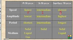
Types of Seismic Waves generated in an earthquake, including definitions and characteristics
|
|
|
|
|
Elastic Rebound Theory
|
Stress that are being applied to the earth's crust, when the limit is exceeded the fault will break. This will cause earthquakes to repeat over time. We can measure the time- the recurrence movement
|
|
|
|
Focus vs. Epicenter of an earthquake
|
focus is where the crack begins (in the earth)
Epicenter the area on the surface of the earth directly above the focus |
|
|
|
Seismograph vs. Seismogram
|
Seismograph is the instrement used to detect movement of the earth.
Seismogram is the actual paper and drawing of the movement of the earth |
|
|
|
Intensity
|
Intensity measures the damage caused by an earthquake, this depends on energy of the earthquake, distance from the earthquake, local ground conditions, types of buildings
|
|
|
|
Magnitude measures the energy released during an earthquake
|
Richter magnitude scale
Mr=log10(amplitude) |
|
|
|
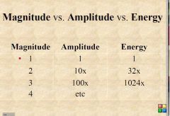
Magnitude vs amplitude vs energy
|
|
|
|
|
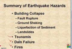
Earthquake Hazards
|
|
|
|
|
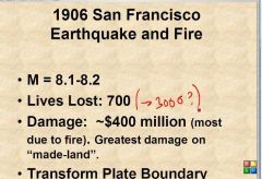
1906 San Francisco
|
|
|
|
|
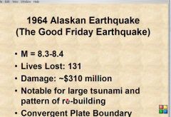
964 Alaskan Earthquake
|
|
|
|
|
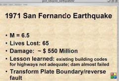
1971 Fernado
|
|
|
|
|
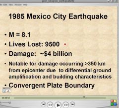
1985 Mexico City
|
|
|
|
|
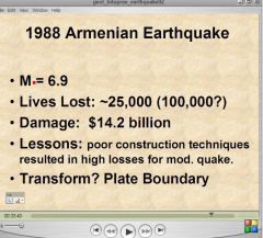
1988 Armenian Earthquake
|
|
|
|
|
1989 Loma Prieta (World Series) earthquake
|
|
|
|
|
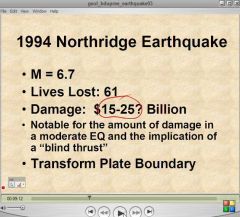
1994 Northridge Earthquake
|
|
|
|
|
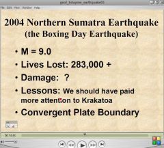
2004 Boxing Day Earthquake
(Northern Sumatra Earthquake |
|
|
|
|
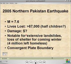
2005 Pakistan Earthquake
|
|
|
|
|
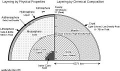
Compositional and Mechanical Layers
|
|
Mechanical layers - based on physical properties
* lithosphere - brittle, cold. Consists of both uppermost mantle and oceanic and continental crust. Oceanic lithosphere is ~100 km thick, continental is ~150 to 200 km thick. * asthenosphere - ductile, flowing, hot. ~450 km thick * mesosphere - lowermost part of mantle * outer core - molten Fe,Ni; inner core - solid Fe, Ni Compositional layers : crust (continental & oceanic), mantle, and core * oceanic crust - basaltic, 5-10 km thick * continental crust - andesitic, 20-70 km thick * mantle - ultramafic (peridotite) * core - Fe,Ni |
|
|
Refraction
|
Waves Bending when passing through different layers. These Behaviors can be used to identify a wave.
|
|
|
|
P-wave
|
|
|
|
|
S-waves
|
|
|
|
|
What is the Moho and how was it detected?
|
This is the layer between the crust and the mantle. It was Discovered by Mohorocicic using seismic waves
Moho Discontinuity - separates crust from Mantle - Density = 3.3 g/cc - Olivine and Pyroxene dominate |
|
|
|
Isostacy:
|
The concept of a floating crust in gravitational balance
|
|
|
|
mountain Roots
|
That is, mountains are not simply thicker continental crust sitting on denser rocks. Just like ice floats on water with about 10% of its mass above water, mountains have a significant part of their mass below the surface of the Earth in the form of the low density root.
|
|
|
|
Causes of Geothermal heat
|
* Much of the heat is believed to be created by decay of naturally radioactive elements. An estimated 45 to 90 percent of the heat escaping from the Earth originates from radioactive decay of elements within the mantle.[8]
* Heat of impact and compression released during the original formation of the Earth by accretion of in-falling meteorites. * Heat released as abundant heavy metals (iron, nickel, copper) descended to the Earth's core. * Some heat may be created by electromagnetic effects of the magnetic fields involved in Earth's magnetic field. * 10 to 25% of the heat flowing to the surface may be produced by a sustained nuclear fission reaction in Earth's inner core, the "georeactor" hypothesis.[9] * Heat may be generated by tidal force on the Earth as it rotates; since land cannot flow like water it compresses and distorts, generating heat. |
|
|
|
What are the mechanisms of heat transfer in the solid earth?
|
Convection- is the process of moving heat through a liquid
Conduction- the flow of heat through a material by collision of atoms or flow of elctrons. |
|
|
|
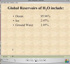
Another Way to View Global Reseviors
|

|
|
|
|
Another Way to View Global Reseviors
|
|
|
|
|
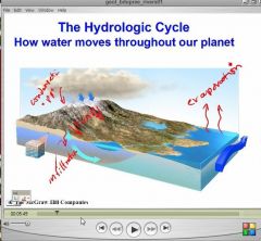
Processes by which H2O move from one reservoir to another.
|
|
Condensation
Precipitation Infiltration Run-off Evaporation |
|
|
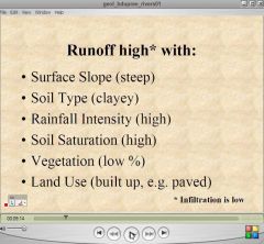
What Determines the volume of Floodwater at a specific location
|
Amount of Rainfall
Amount of infiltration area of the rainfall Runoff= Rainfall- Infiltration |
|
|
|
Excess Runoff
|
|
|
|
|
Effects on runoff
|
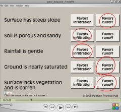
Red circles
|
|
|
|
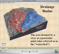
Drainage Basin
|
|
|
|
|
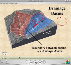
Drainage Divide
|
|
|
|
|
Excess Runoff
|
Rainfall- infiltration
|
|
|
|
determine total volume
|
Excess Rainfall X Drainage Area
|
|
|
|
Discharge
|
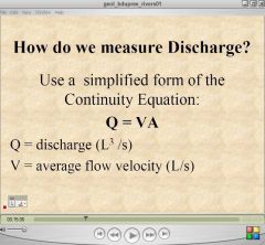
The Rate at which the water flows past a specific point
Equation= Volume/ unit time |
|
|
|
Hydrograph
|
plots discharge or state (water elevation) at a gaging station over time
|
|
|
|
Recurrence interval (flood Frequency)
|
the annual recurrence interval (RI) of an event of a particular magnitude is the average number of years between events of similar or greater magnitude
Thus, the 100 year flood is one which occurs, on average, once every 100 years. |
|
|
|
Recurrence interval equation (flood Frequency)
|
RI= Number of years of record+1/ rank of event
|
|
|
|
Exceedence Probability (flood Frequency)
|
The probability of an event of a particular magnitude being equaled or exceeded any given year is P=1/ RI
Therefore, a 100 year flood has a 1 in 100 probability of being equaled or exceeded any given year |
|
|
|
1% Flood
2% flood |
is 100 years flood
is a 50 year flood |
|
|
|
How and why do hydrographs differ before and after urbanization?
|
Amount of Pavement,
|
|
|
|
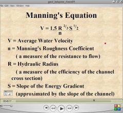
How can you increase velocity in a channel? Why would you want to do that?
|
Decrease resistance to flow
increase channel efficiency Increase slope To decrease flooding |
|
|
|
Mannings equation
|
|
|
|
|
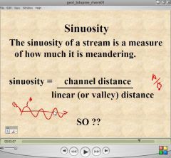
What is Sinuosity?
|
|
|
|
|
Meandering
|
is the moving back and forth of a river
|
|
|
|
How and why has sinuosity changed in Brays Bayou between 1946 and the present?
|
The slope has increased the slope so this will increase the speed. Straightening river reduces flooding
|
|
|
|
What is the effect of channelization on downstream flooding? Alternatives?
|
increased down stream flooding and erosion
Encourages development of floodplains Store extra water in retention ponds |
|
|
|
Reserves VS Resources
|
• Resource: a naturally occurring
material that is of potential economic use. • Reserve: a resource that can be economically and legally used today. |
|
|
|
Bed Rock Stream
|
Cut into bed rock
|
|
|
|
Alluvial Streams
|
Most alluvial streams can be subdivided on the basis of the pattern in map view: BRaided streams and Meandering streams
|
|
|
|
Lateral Migration
|
Point Bar- New land created by deposition
Cut bank- is the bank being moved |
|
|
|
Meander Cutoff
|
creates the oxbow lake
|
|
|
|
Meander Scrools
|
levels of deposition added. it tells us the river growth
It shows us lateral migration |
|
|
|
Natural Levees
|
Sediments deposited along a river bed during a flood
need many years and many floods |
|
|
|
Red River
|
Board is always changing
|
|
|
|
San Jacinto River
|
Exposed pipeline
Worst inland in history CAused by Meandering Cutoff |
|
|
|
Oyster Creek
|
used to BRazos River
Shifted because of a major flood Caused by avulsion (the large scale shift of a major river) |
|
|
|
Atchafalaya
|
old river on the Missippi Delta
|
|
|
|
Simonton
|
Simenton was incorporated in 1979 major floods in 1991 and 1994
Significant erosion is locally occurring in the simenton on both sides |
|
|
|
Base Level
|
The level below which a stream cannot erode. (a lake or sea level)
|
|
|
|
Downstream of a Dam
|
New delta is built upstream
New erosion downstream because the water is free from sediment |
|
|
|
What happened on Sept 8, 1900? And in 1915?
|
Hurricane struck Galveston in 1900
Hurricane Struck NO in 1915 |
|
|
|
Sediment budget
|
Sediment budget refers to the balance between sediment added to and removed from the coastal system
|
|
|
|
Wave Base
|
the depth at which the effect of the is no longer felt
|
|
|
|
Shallow water wave
|
Slower than a deep water wave
the wave will build up |
|
|
|
Zone of wave build up
|
wave period remains constant
Wave leanth decrease Wave Height increase Wave refration can occur |
|
|
|
How does wave refraction occur in the near shore zone and why is it important? How does it affect headlands and bays?
|
the bending of wave with a change in velocity
Bay- Diverege at the bay (depostion) Headland- converage on headland (erosion |
|
|
|
What is longshore drift? How and why does it occur? Why is it important?
|
The transport of sediment (e.g.
sand) parallel to the shoreline, mainly in the surf and swash zone. Longshore drift is driven by longshore currents set up by waves coming into the shoreline at an angle less than 90o. |
|
|
|
Sources of Sediment
|
Rivers
Erosion Longshore Drift |
|
|
|
Groin
|
Impermeable Structures perpendicular to the shoreline
Purpose: to trap sediment, thereby preventing or reducing beach erosion Effects: points past the groins will have increased erosion |
|
|
|
Jetties
|
Impermeable structures perpendicular to
the shoreline, on either side of an inlet. Purpose: to reduce sedimentation in the inlet, thereby improving navigation Effect increased deposiont and erosion Ocean city and Freeport |
|
|
|
Sea Walls
|
Impermeable structures parallel to the
shoreline, usually on the landward side of the beach. Purpose: to prevent erosion of the land adjacent to the beach. Protects land but accelerated erosion |
|
|
|
Breakwaters
|
Impermeable structures parallel to and
offshore from the shoreline. Purpose: to protect a beach or boat anchorage from incoming waves |
|
|
|
Are Texas beaches eroding, and if not, what is happening? Are there any exceptions to this generalization?
|
not eroding
beaches are moving only beachfront land is eroding |
|
|
|
Beach nourishment
|
the artificial addition of sand to reduce the rate of beach erosion
Problem is a one time short term fix |
|
|
|
What will be the effect of the large “Geo- tubes” placed behind the beach just down-drift of the Galveston seawall?
|
it is an artificial Dune.
It has not stopped erosion |
|
|
|
Can the size of reserves and resources change, and if so, how?
|
The size of the reserve can change; however, the size of the resource cannot change
|
|
|
|
Main Green house Gas
|
CO2
|
|
|
|
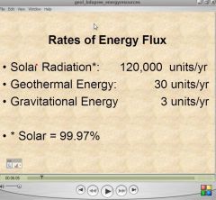
What are the sources (and relative magnitudes) of energy on the earth?
|
|
|
|
|
Fossil Fuels
|
those energy resources that have formed as the result of the burial and subsequent transformation of organic material
|
|
|
|
oil and gas formed
|
Production of large amounts of Biomass
• Preservation in a reducing (oxygen-poor) environment • Burial increases heat and pressure, causing maturation ( the breakdown of organic matter into a liquid or gas) in a source rock. |
|