![]()
![]()
![]()
Use LEFT and RIGHT arrow keys to navigate between flashcards;
Use UP and DOWN arrow keys to flip the card;
H to show hint;
A reads text to speech;
63 Cards in this Set
- Front
- Back
|
clouds |
an area of the atmosphere that saturated or supr saturated |
|
|
Types of clouds : |
warm clouds (T>-10) - consist exclusively of water droplets
cold clouds (T<-10) - tiny ice cristals. snow forms in here |
|
|
Clouds attributes (names)on basis of altitude: |
cirro : high level (always cold)
alto: mid level |
|
|
clouds attributes (names) on basis of pattern |
cumulo : vertically developed (cold)
strato: stratified, confined to a single level , layered (warm)
|
|
|
clouds attributes (names) based on ability to produce precipitation |
nimbo: precipitation bearing (cold and warm) |
|
|
Cloud types : |
high clouds : -cirrus -cirrocumulos -cirrostratus -contrails
mid-clouds: -altocummulus -altostratus
low clouds: -stratus -nimbostratus -stratocumulus -cumulus -cumulunimbus
|
|
|
High clouds: |
always cold altitude 20,000 + |
|
|
cirrus: |
High cold wispy streched out very thin allow sun to shine throught |
|
|
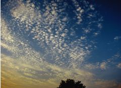
Cirrocumulos |
*high *fine grained appereance *bubble like clouds *interwoven with blue sky *a little vertical development (rising motions with cloud elements, sinking motions surronding cloud elements ) *variation in vertical and horizontal air motions --> bumpy plane ride |
|
|
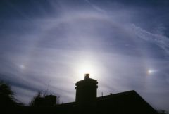
cummulostratus |
*high *very thin *cover the whole sky in a layered fashion given - a ring-like appereance around the sun - mini-rainbow; diffraction of light (sun dogs) |
|
|
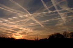
contrails: |
-high -trail of loud consisting of liquid water
1. condensation and largely deposition 2. water-vapor comes out of plane engines and instantaneously turns to ice crystals 3. the relative humidity is close to 100%
|
|
|
middle clouds: |
8000- 20,000 |
|
|
altocumulus: |
middle clouds warm similar to cirrocumulus just lower in the column |
|
|
altostratus: |
*middle clouds *warm *thicker *lower in the atmosphere so block out sunlight more than cirrostratus *ring around the sun |
|
|
low clouds : |
500 to 8,000 high |
|
|
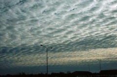
stratus |
*low level *stratified *effectively block out the sun (can produce drizzle, but not measurable |
|
|
Nimbostratus |
*low thicker *darker *producing recipitation *streaked appereance
rather featureless as falling precipitation obscures cloud edges |
|
|
stratocumulus |
*low *stratified *not thick *connected with a stable atmosphere (air doesn't want to move vertically )
note that the dark clouds are associated with a low sun angle |
|
|
clouds associated with vertical development |
cumulus cumulunimbus
|
|
|
cumulus: |
*low level *unstable atmosphere(Air is lifting ) *daytime heating when the relative humidity is high *vertical development *late morning hours in carolina summer
*common with daytime heating when the relative hummidity is relatively high *show some vertical development (deeper instability )
|
|
|
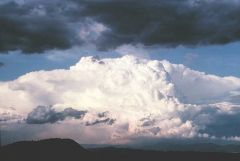
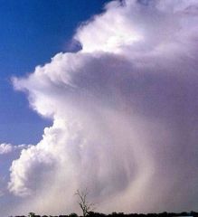
cumulonimbus |
*largest clouds *dark bottom *thunderstorm |
|
|
precipitation |
requires the development of droplet/ snowflakes that are 100 times bigger than cloud water droplets/ice crystals
most clouds don't have precipitation |
|
|
two processes for growing hydrometeors |
a. bergeon
b. collision-coallecence |
|
|
hydometeors: |
refers to any type of precipitation |
|
|
Bergeron process definition : |
grows ice crystal through multiple processes involving all 3 stages of water
requires a cold cloud where ice crystals, water vapor, and supercooled water coexist. |
|
|
bergeron processes: |
deposition of vapor --> ice crystals growth. '
removal of water around ice crystals so relative humidity drops
rising air motions keep growing snowflakes aloft until it becomes too heavy |
|
|
what is the dominant process in bergeon |
deposition is the dominant process |
|
|
is it possible for the bergeron process to occur in lower altitudes creating snow? |
yes, on winter when the surface temperature is cold enough |
|
|
what appereance the bergeron process gives to clouds? |
porvides a distinct glazed and/or streaked appereance |
|
|
bergeron porcess OFTEN produces ice cristals taht acts like seeds for growing hydrometers bellow in the lower portion of the clouds ? |
true |
|
|
what types of clouds does bergeron process occur normally? |
high cold clouds |
|
|
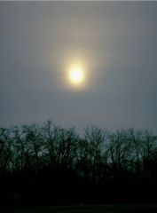
cirrus (image) |

|
|
|
cirrucumulus (image) |
|
|
|
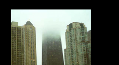
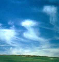
cirrostratus (image) |
|
|
|
contrails (image) |
|
|
|
altocumulus(image) |
|
|
|
altostratus (image) |
|
|
|
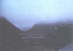
stratus(image) |
|
|
|
startus 2 (image) |
|
|
|
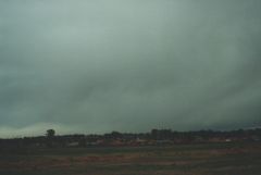
nimbostratus(image) |
|
|
|
stratocumulus (image) |

|
|
|
cumulus (image) |

|
|
|
cumulunimbus (image) |
|
|
|
Bergeron proceess (image)starting |
|
|
|
bergeron process (image ) cold situation |
|
|
|
why do bereron process louds have that aspect ? |
when it produces snowflake steh refelcton of light make them look like tehy are falling or rotating |
|
|
collision coalescence |
hydrometers growth as it collides with smaller dropplets through the sky |
|
|
collision coallescenece characteristics |
only preciotation formation that pperates in warm clouds
can supplement bergeon process in cold clouds
large cloud droplets falls through smaller cloud droplets accumulating them along the way |
|
|
seeder-feeder process |
combination of bergeron and collision coalescence (warmer droplets are feeding teh seeds) |
|
|
seeder feeder scenario 1: |
rain dropletsfrom melted snowflakes are feed by the warm cloud water droplets |
|
|
seeder feeder scenario 2: |
cloud water droplets freeze on falling snowflakes, ina a process called riming teh snowflakes growth in size as it falls though the warmer parts of the cloud |
|
|
is it possible to determine the degree at which a snowflake has being rimed ? |
yes it si |
|
|
precipitation rate: |
amount of precipitation per a given amound of time |
|
|
controls on precipitation rate: |
1. amount of water vapor condensed / deposited out
2. rate of lifting |
|
|
amount of WV condensed/deposited depends on : |
- air temperature
-proximity to warm body of water |
|
|
rate of lifting: |
how quickly the air is being lifted up |
|
|
rate of lifting depends on: |
convective lift an order of magnitude
(stronger teh lift the moretiem teh bergeron process has to make snowflakes
|
|
|
how faster is the convective lift from the frontal lifts ? |
convective lift 10-50 times faster |
|
|
Two precipitation types: |
stratiform
convective |
|
|
startiform |
*sudden changes in temperature, humidity and pressure of air
*warm mets the cold ar and warm is forced to rise
*less intense with over a longer perod time than convective |
|
|
convective |
*precipitation falls as a showers with rapidly changing intensify over a certain areas for a relative short time
*mainly in a conditionally unstable or moist atmosphere |
|
|
what type of clouds produce startiform precipitation? |
nimbostratus |
|
|
what type of cloud produces convective precipitaton? |
cumulonimbus |