![]()
![]()
![]()
Use LEFT and RIGHT arrow keys to navigate between flashcards;
Use UP and DOWN arrow keys to flip the card;
H to show hint;
A reads text to speech;
20 Cards in this Set
- Front
- Back
|
What does CAMS stand for? |
Computer assisted mapping system- which links appraisal records to the corresponding parcel on the map |
|
|
What does GIS stand for? |
Geographic information system which links the appraisal records to the corresponding parcel on the map |
|
|
What does ORMAP stand for? |
The Oregon Map Project it’s ongoing purpose is to develop a state wide property tax parcel base map that is digitally and continually maintained. It will support a variety of GIS applications and has improved administration of the property tax system |
|
|
What does USRSS stand for? |
It stands for the US rectangular survey system. This is what the Oregon cadastral map system is based on |
|
|
The Oregon baseline divides what? |
North and South townships |
|
|
What does the Willamette meridian divide? |
East and west ranges |
|
|
Map of baseline and Meridian |
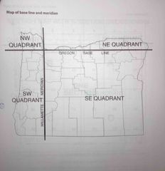
Map of baseline and Meridian |
|
|
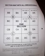
How many Sections is one township divided into? |
36 |
|
|
Townships are approximately this many square miles |
6 mi.². 6 miles long by 6 miles wide |
|
|
How big is a section? |
Approximately 1 mi.² |
|
|
How many acres are in one square mile? |
640 |
|
|
Sections are divided into for 1/4 sections. Each approximately is this size |
1/2 mi.² and contains 160 acres |
|
|
A section map with all the breakdowns |
Back (Definition) |
|
|
How big is a quarter quarter section? |
It’s approximately 1/4 square mile and contains approximately 40 acres |
|
|
The standard taxlot number in the Oregon cadastral map system is a combination of these four things |
Map number, parcel number or unit ownership number, special interest number if applicable, and code number |
|
|
The unique property identification number used in the Oregon Cadastral map system is called this |
Parcel number |
|
|
Give an example of a parcel number |
It is referred to as a “two-zero” number such as 100, 200, 300, 400 |
|
|
Can parcel numbers be reused? |
No, if parcel numbers are reused the previous history is destroyed and research becomes almost impossible |
|
|
Give an example of a special interest number |
A special interest number always contains a letter followed by a number. Examples include: A: improvements only F: Air space only-above a given elevation M: Mineral rights - assessed and text only if actively being mined as the assessment date S: subsurface ownership U: Undivided interests |
|
|
What parcel number does a condominium start with? |
90000 |