Reading...
![]()
Play button
![]()
Play button
![]()
Use LEFT and RIGHT arrow keys to navigate between flashcards;
Use UP and DOWN arrow keys to flip the card;
H to show hint;
A reads text to speech;
143 Cards in this Set
- Front
- Back
|
84. Circles parallel to the equator are called ____ . |
D. Parallels of Latitude
|
|
|
85. The Prime Meridian is the _____. A. great circle passing through the north and south poles B. line located at 0°latitude C. great circle running east and west around the earth D. line located at zero degrees (0°) longitude |
D. line located at zero degrees (0°) longitude
|
|
|
86. Positions on the earth’s surface are described in terms of ____. A. latitude and longitude B. latitude and parallels C. degrees and arcs D. longitude and meridians |
A. latitude and longitude
|
|
|
87. A nautical mile equals statute miles (SM). A. .87 B. 1.15 C. 1.5 D. 1.87 |
1.15
|
|
|
88. Coordinated Universal Time (UTC) is also referred to as time. A. Alfa B. Charlie C. X-ray D. Zulu |
D. Zulu
|
|
|
89. Time zones are established for every ____. A. 15’ of longitude B. 15°of latitude C. 15°of longitude D. 15’ of latitude |
C. 15°of longitude
|
|
|
90. How do you convert local Daylight Savings Time to UTC? A. Subtract the conversion factor. B. Add the conversion factor, then subtract 1 hour. C. Subtract the conversion factor, then add 1 hour. D. Add the conversion factor, then add 1 hour. |
B. Add the conversion factor, then subtract 1 hour.
|
|
|
91. The angular difference between true and magnetic north at a given location is called _____. A. correction B. variation C. compensation D. deviation |
B. Variation
|
|
|
92. King Air 2425K departed “A” at 2228 UTC. With a consistent 180-knot ground speed, N2425K arrived at destination “E” at 0258 UTC. How long did it take the aircraft to cover the distance from “B” to “C?” A_______ B ________C ________D_________ E 160NM ? 105NM 185NM A. 1.5 HR B. 2HR C. 1.75 HR D. 2.25 HR |
B. 2HR
|
|
|
93. Parallels and meridians are divided into ___, minutes and seconds. A. circles B. days C. degrees D. hours |
C. degrees
|
|
|
94. 100 nautical miles equals _____statute miles. A. 130 B. 95 C. 87 D. 115 |
D. 115
|
|
|
95. The basic form of navigation which uses visual reference to landmarks is ____. A. pilotage B. dead reckoning C. rate, time, and distance D. radio navigation |
A. Pilotage
|
|
|
96. 2 PM on a 24-hour clock equals ____. A. 1200 B. 0200 C. 2200 D. 1400 |
D. 1400
|
|
|
97. An aircraft departs Denver at 9 P.M. (MST) and travels 3 hours, landing in Boston (EST). What was the aircrafts arrival time UTC? (conversion factor EST to UTC is +5) A. 0700 B. 1700 C. 0200 D. 0600 |
A. 0700
|
|
|
98. A line connecting points of zero variation is called a(n) _______. A. isogonic line B. agonic line C. magnetic line D. meridian |
B. agonic line
|
|
|
99. How long would it take an aircraft with a ground speed of 130 knots to fly 650 NM? A. 4 hours, 30 minutes B. 5 hours C. 5 hours, 30 minutes D. 6 hours |
B. 5 Hours
|
|
|
100. The purpose of parallels of latitude is for measuring degrees of latitude ____. A. east and west of the equator B. north and south of the equator C. north and south of the Prime Meridian D. east and west of the Prime Meridian |
B. north and south of the equator
|
|
|
101. A pilot has determined the true heading from Oklahoma City to Kansas City is 020°. The magnetic variation is 7°E. What magnetic heading should be flown? A. 013° B. 020° C. 027° D. 031° |
A. 013°
|
|
|
102. The only line of latitude that is a great circle is the _____. A. Prime Meridian B. Equator C. International Dateline D. Rhumb Line |
B. Equator
|
|
|
103. An aircraft encounters a 20 KT crosswind and makes no heading correction. After 1 hour of flight, how far off course would the aircraft be? A. 10NM B. 10SM C. 20NM D. 20SM |
C. 20 NM
|
|
|
489. True course corrected for the effects of wind is _____. A. magnetic heading B. magnetic track C. true heading D. true track |
C. True Heading
|
|
|
498. An aircraft travels 300 nautical miles over the ground in three hours while experiencing a tailwind of 25 knots. The aircraft’s ground speed is ____ knots. A. 150 B. 125 C. 100 D. 90 |
B. 100
|
|
|
499. The navigational method based solely on computing air speed, course, wind, ground speed, and elapsed time is _____. A. dead reckoning B. VFR navigation C. pilotage D. radio navigation |
A. Dead Reckoning
|
|
|
500. Circles parallel to the equator are called ____ . A. great circles B. parallels of longitude C. meridians D. parallels of latitude |
D. parallels of latitude
|
|
|
508. What condition will cause an aircraft’s indicated airspeed to decrease? A. A decrease in altitude or temperature B. A decrease in altitude or an increase in temperature C. An increase in altitude or a decrease in temperature D. An increase in altitude or temperature |
D. An increase in altitude or temperature
|
|
|
509. Time zones are established for every ___. A. 15’ of longitude B. 15°of latitude C. 15°of longitude D. 15’ of latitude |
C. 15°of longitude
|
|
|
514. Which formula is correct when D = distance, S = speed, and T = time? A. S=DxT B. D=S÷T C. D=SxT D. T=S x D |
C. D=SxT
|
|
|
515. One minute of latitude is equal _____to any place on the Earth’s surface. A. 60 nautical miles (NM) B. 60 statute miles (SM) C. 1 nautical mile (NM) D. 1 statute mile (SM) |
C. 1 nautical mile (NM)
|
|
|
520. An aircraft travels at 450 knots for 2 hours, 30 minutes. How many nautical miles has the aircraft traveled? A. 1,050 miles B. 1,075 miles C. 1,100 miles D. 1,125 miles |
D. 1,125 miles
|
|
|
521. Lines connecting points of equal difference between true and magnetic north are called ____ lines. A. agonic B. isochronous C. isogonic D. isobaric |
C. isogonic
|
|
|
584. An aircrafts TAS is significantly higher than its IAS _____. A. at low altitudes B. at sea level C. at high altitudes D. with a tailwind |
C. at high altitudes
|
|
|
635. An aircraft travels 300 nautical miles over the ground in three hours while experiencing a tailwind of 25 knots. The aircraft’s ground speed is ___knots. A. 150 B. 125 C. 100 D. 75 |
C. 100
|
|
|
636. The navigational method based solely on computing air speed, course, wind, ground speed, and elapsed time is ______ . A. radio navigation B. RNAV navigation C. FMS D. dead reckoning |
D. Dead reckoning
|
|
|
676. One minute of latitude is equal to ________ any place on the Earth’s surface. A. 5000 feet B. ó nautical mile C. 1 nautical mile (NM) D. 1 statute mile (SM) |
C. 1 Nautical Mile (NM)
|
|
|
677. A line of equal magnetic variation is called a/an _____ line. A. isogonic B. agonic C. magnetic D. longitude |
B. isogonic
|
|
|
285. Low altitude RNAV route 12 is spoken: A. “Q twelve” B. “Quebec twelve” C. “T twelve” D . “Tango twelve” |
D. “Tango Twelve”
|
|
|
286. The different classes of VORs are ______. A. High, Low, Terminal B. High, Medium, Low C. High, Low, Compass Locator D. High, Medium, Terminal |
A. High, low, terminal
|
|
|
287. The bearing and DME frequencies of a TACAN are paired and assigned by _______numbers. A. course B. radial C. channel D. heading |
C. channel
|
|
|
288. Generally, the vertical dimensions of a low altitude VOR airway are from _____. A. the surface up to but not including 18,000 feet AGL B. the surface up to but not including 18,000 feet MSL C. 12,000 feet AGL up to, but not including 18,000 feet MSL D. 1,200 feet AGL up to, but not including, 18,000 feet MSL |
D. 1,200 feet AGL up to, but not including, 18,000 feet MSL
|
|
|
289. The non-radar lateral protected airspace of a victor airway within 51NM of the NAVAID is _____ . A. 8 NM either side of centerline B. 4 NM either side of centerline C. 10 NM either side of centerline D. 20 NM either side of centerline |
B. 4 NM either side of centerline
|
|
|
290. The component of the ILS which gives lateral course guidance to the runway is the _____. A. localizer B. marker beacon C. glide slope D. DME |
A. localizer
|
|
|
291. Which is not a characteristic of a Nondirectional Radio Beacon (NDB)? A. More accurate than a VOR B. Provides a bearing to be flown during an approach C. Adversely affected by lightning D. Used to establish nonprecision approaches |
A. More accurate than a VOR
|
|
|
292. The GPS receiver needs at least ____ satellites to yield three- dimensional information, including position, velocity, time, and altitude. A. 3 B. 4 C. 5 D. 6 |
B. 4
|
|
|
293. The difference between DME slant-range and actual horizontal distance is greatest _____. A. at low altitude close to the NAVAID B. at high altitude far from the NAVAID C. at low altitude far from the NAVAID D. at high altitude close to the NAVAID |
D. at high altitude close to the NAVAID
|
|
|
294. An Non Directional Beacon (NDB) used in conjunction with the Instrument Landing System (ILS) is called a(n) _____. A. compass locator B. marker beacon C. Outer Marker (OM) D. Automatic Direction Finder (ADF) |
A. Compass locator
|
|
|
488. The maximum usable range of an “H” class VOR is ____. A. 25 NM B. 130 NM C. 40NM D. 100 NM |
B. 130 NM
|
|
|
507. The component of the ILS which provides the descent angle is the ____. A. marker beacon B. localizer C. glide slope D. back course marker |
C. glide slope
|
|
|
513. A VHF Omni-Directional Range (VOR) has how many usable magnetic radials? A. 90 B. 180 C. 360 D. 350 |
C. 360
|
|
|
519. Generally, ATS routes defined from 1,200 feet AGL to, but not including 18,000 feet MSL describe ____. A. victor routes B. jet routes C. Q routes D. MTRs |
A. Victor routes
|
|
|
585. VORs are classed according to operational use. There are three classes. Which one of the selections below is not one of those classes? A. T (Terminal) B. UH (Ultra high altitude) C. H (High altitude) D. L (Low Altitude) |
B. UH (Ultra high altitude)
|
|
|
678. Which of the following is not a characteristic of the Global Positioning System (GPS)? A. The system is affected by weather.) B. The system provides satellite-based radio navigation. C. The system provides highly accurate position information. D. The system provides velocity information. |
A. The system is affected by weather.
|
|
|
131. Which of the following is assigned by ATC to a single aircraft and used for radar identification and flight tracking? A. non-discrete code B. discrete code C. mode C D. aircraft identification |
B. discrete code
|
|
|
132. Which instrument is NOT connected to the pitot-static system? A. Airspeed indicator B. Vertical speed indicator C. Attitude indicator D. Altimeter |
C. Attitude indicator
|
|
|
133. What may be obtained from the attitude indicator? A. Rate of turn B. Degrees of bank C. Height above sea level D. Rate of climb |
B. Degrees of Bank.
|
|
|
134. The major components of the pitot-static system are the _____ . A. absolute and indicated altitude indicators B. vacuum pump and regulator C. attitude and heading indicators D. impact and static pressure chambers, and lines |
D. impact and static pressure chambers, and lines.
|
|
|
135. As a controller, when an aircraft under your control jurisdiction informs you that it is responding to a TCAS RA, you ________. A. are responsible for maintaining separation from the intruder aircraft. B. shall not issue instructions contrary to the RA. C. may discontinue traffic advisories and safety alerts. D. shall immediately issue an amended clearance. |
B. shall not issue instructions contrary to the RA
|
|
|
136. Because of precession, the heading indicator is periodically set by the pilot to agree with the . A. attitude indicator B. altimeter C. magnetic compass D. Directional Gyro (DG) |
C. Magnetic Compass
|
|
|
137. In order to fly a desired course toward a VOR station, the pilot must ensure that the aircraft’s heading agrees with the course set on the VOR course selector, the instrument displays a “TO” indication, and the_. A. VOR needle is centered B. aircraft is not climbing or descending C. magnetic compass is not precessed D. airspeed is constant |
A. VOR needle is centered
|
|
|
138. The altimeter depends on which of the following for its operation? A. Pitot tube. B. Gyro. C. Static port. D. Rudder. |
C. Static Port.
|
|
|
139. A transponder code consists of four numbers from zero to seven with possible codes. A 4,006 B. 4,066 C. 4,086 D. 4,096 |
D. 4,096
|
|
|
140. The FMS is . A. a computer data base used for navigation B. a radio NAVAID receiver C. a gyroscopic instrument D. Inoperable with a clogged pitot |
A. a computer data base used for navigation
|
|
|
141. In most small aircraft, if the vacuum pump fails, which instruments become inoperative? A. Airspeed indicator and turn and bank B. Altimeter and directional gyro C. Heading indicator and attitude indicator D. Vertical speed indicator and attitude indicator |
C. Heading indicator and attitude indicator
|
|
|
142. Hypoxia is a condition of the body that exists when there is . A. a lack of oxygen in the body tissue B. a lack of oxygen in the air C. excessively fast breathing D. a lack of carbon dioxide in the body |
A. a lack of oxygen in the body tissue
|
|
|
482. Which of the following transponder codes is invalid? A. 2345 B. 3456 C. 4567 D. 5678 |
D. 5678
|
|
|
491. Which of the following is a gyroscopic instrument? A. Heading indicator B. Altimeter C. Airspeed indicator D. Vertical speed indicator |
A. Heading indicator
|
|
|
501. A lack of oxygen in the body tissue results in ______. A. Hyperventilation B. Vertigo C. Hyperextension D. Hypoxia |
D. Hypoxia
|
|
|
516. Which instrument would be affected if the pitot tube became clogged? A. Altimeter B. Vertical speed indicator C. Heading indicator D. Airspeed indicator |
D. Airspeed indicator
|
|
|
591. Symptoms of hypoxia include all of the following except . A. slow reactions B. impaired thinking C. increased alertness D. unusual fatigue |
C. increased alertness
|
|
|
642. Which instrument does not depend on 'rigidity in space' for its operation? A. heading indicator B. attitude indicator C. magnetic compass D. turn coordinator |
C. magnetic compass
|
|
|
643. Which of the following is assigned by ATC to a single aircraft and used for radar identification and flight tracking? A. non-discrete codes B. discrete codes C. mode C D. aircraft identification |
B. discrete codes
|
|
|
683. The purpose of TCAS is to . A. provide standard separation B. prevent a collision C. replace ATC D. ensure terrain avoidance |
B. prevent a collision
|
|
|
105. In the airport data “18 L 100 122.8” on a Sectional Aeronautical Chart, the number “18” indicates the_. A. airport elevation B. length of the longest runway C. runway number of the primary runway D. height of the tallest obstruction within 5 nautical miles |
A. airport elevation
|
|
|
106. VFR flyway planning charts are found on _. A. IFR/VFR planning charts B. VFR Terminal Area Charts C. Sectional Charts D. WAC Charts |
B. VFR Terminal Area Charts
|
|
|
107. Frequencies placed just above a communication box on a Sectional Aeronautical Chart are used to contact which type of facility? A. En Route Air Traffic Control Center B. Approach Control C. Tower D. Automated Flight Service Station |
D. Automated Flight Service Station
|
|
|
108. The boundary of Class C airspace is depicted on a Sectional Aeronautical Chart by a solid line. A. blue B. magenta C. brown D. black |
B. magenta
|
|
|
109. Which document would be most useful to a controller when recommending a suitable airport to a pilot in the event of an emergency? A. JO 7110.65 B. Aeronautical Information Manual C. Airport/Facility Directory D. Letter of Agreement |
C. Airport/Facility Directory
|
|
|
110. Information NOT found on sectional aeronautical charts are . A. MEAs and MOCAs B. VOR, VORTAC’s, NDB’s, as well as their position, identification, and frequencies C. MOAs, Restricted, Prohibited, Alert and Warning Areas D. airports |
A. MEAs and MOCAs
|
|
|
111. The Airport/Facility Directory is published every days. A. 28 B. 56 C. 112 D. 180 |
B. 56 days
|
|
|
112. What chart(s) or publication would you use to find out if an airport has a control tower, and the tower frequency? A. Sectional Aeronautical Chart B. Terminal Area Chart C. Airport/Facility Directory D. All of the above |
D. All of the above
|
|
|
487. Class D airspace on a sectional aeronautical chart is depicted by a _____ line. A. dashed blue B. solid blue C. solid magenta D. dashed magenta |
A. Dashed blue
|
|
|
496. Basic terrain contour lines on a Sectional Aeronautical Chart are generally spaced at ____ foot intervals. A. 100 B. 500 C. 1,000 D. 2,000 |
B. 500
|
|
|
497. The primary use for Sectional Aeronautical Charts is navigation by speed aircraft. A. IFR; slow and medium B. VFR; high C. IFR; high D. VFR; slow and medium |
D. VFR; slow and medium
|
|
|
506. Where are Class B airspace operating rules found? A. On the Terminal Area Chart B. On the inside flap of a Sectional Aeronautical Chart C. In the World Aeronautical Chart Legend D. Only in the Airport/Facility Directory |
A. On the Terminal Area Chart
|
|
|
512. Airports are listed in the A/FD in which order? A. largest to smallest B. state, airport, city C. city, airport, state D. state, city, airport |
D. state, city, airport
|
|
|
518. World Aeronautical Charts are used primarily for which type of navigation? A. RNAV B. Pilotage C. IFR D. Satellite |
B. Pilotage
|
|
|
586. Class B operating rules can be found on the back of _. A. IFR/VFR planning charts B. VFR Terminal Area Charts C. Sectional Charts D. WAC Charts |
B. VFR Terminal Area Charts
|
|
|
638. How often is the World Aeronautical Chart published? A. every 56 days B.every 6 months C.every 12 months D.every 24 months |
C. every 12 months
|
|
|
679. Sectional Aeronautical Charts are designed to be used for navigation of speed aircraft. A. instrument; slow/medium B. visual; slow/medium C. required prior to entering controlled airspace D. required prior to departure from within controlled airspace. |
B. visual; slow or medium
|
|
|
680. Which document would you use to determine type of fuel available at an airport? A. US Terminal Procedures Charts B. Airport/Facility Directory C. Sectional Chart D. IFR Area Chart |
B. Airport/Facility Directory
|
|
|
295. When NO MEA is depicted, the MEA on a jet route is feet MSL. A. 14,500 B. 18,000 C. 24,000 D. 45,000 |
B. 18,000
|
|
|
296. Which chart furnishes terminal data for IFR flight in congested areas? A. IFR Area Charts B. Terminal Area Charts C. Airport/Facility Directory D. En Route Low Altitude Charts |
A. IFR Area Charts
|
|
|
297. Which chart(s) depict ATIS frequencies where ATIS is available? A. En Route Low Altitude Chart B. En Route High Altitude Chart C. IFR Area Chart D. BothAandC |
D. Both A and C
|
|
|
298. Which of the following is a requirement for an airport to be published on the IFR EnRoute High Altitude Chart? A. Has a published instrument approach. B. Has a 5000’ or greater hard surfaced runway. C. Has an operational ATCT D. Is public use. |
B. Has a 5000’ or greater hard surfaced runway
|
|
|
299. If NO changeover point is depicted along an airway, it means that _. A. the airway segment crosses through uncontrolled airspace B. either NAVAID can be used for the entire length of the route segment C. there is a gap in NAVAID signal coverage along the airway D. the changeover is to be made at the halfway point between the two NAVAIDs |
D. . the changeover is to be made at the halfway point between the two NAVAIDs
|
|
|
300. How is Class A airspace depicted on an En Route High Altitude Chart? A. As a shaded brown area B. In blue, with a solid blue border C. With a hatched blue line around the boundary D. Open white area |
D. Open white area
|
|
|
301. On an En Route Low Altitude chart, prohibited, restricted, and warning areas are shown within boundaries. A. solid grey B. blue hatched C. light brown D. solid magenta |
B. Blue Hatched
|
|
|
302. Chart(s) that are specifically designed to provide aeronautical information used during instrument flight A. En Route Low Charts B. En Route High Charts C. IFR Area Charts D. All of the above |
D. All of the above
|
|
|
303. En Route Low Altitude Charts are published every . A. 56 days B. 112 days C. 3 months D. 6 months |
A. 56 Days
|
|
|
486. Solid triangles indicate . A. VOR changeover points B. DME fixes C. compulsory reporting points D. substitute route structure |
C. compulsory reporting points
|
|
|
494. The primary purpose of an IFR Area Chart is to furnish . A. VFR reporting points B. visual landmarks for use in congested areas C. terminal data for VFR flights in congested areas D. terminal data for IFR flights in congested areas |
D. terminal data for IFR flights in congested areas
|
|
|
495. The En Route Low Altitude charts are for use below . A. 18,000 feet MSL B. 18,000 feet AGL C. 12,500 feet MSL D. 14,000 feet MSL |
A. 18,000 MSL
|
|
|
504. Chart(s) that are specifically designed to provide aeronautical information used during instrument flight A. En Route Low Charts B. En Route High Charts C. IFR Area Charts D. All of the above |
D. All of the above
|
|
|
505. An asterisk (∗) before an altitude along a low altitude airway indicates a(n) . A. MOCA B. MCA C. MEA D. MRA |
A. MOCA
|
|
|
511. On an En Route High Altitude Chart, all NAVAIDs shown are class ______, unless otherwise identified. A. Low B. High C. Terminal D. Regional |
B. High
|
|
|
587. The primary purpose of an IFR Area Chart is to furnish . A. VFR reporting points B. visual landmarks for use in congested areas C. navigation information using a smaller scale that the En Route Low Altitude Chart D. terminal data for IFR flights in congested areas |
D. terminal data for IFR flights in congested areas
|
|
|
639. En Route Low Altitude Charts are published every . A. 56 days B. 112 days C. 3 months D. 6 months |
A. 56 days
|
|
|
681. On an En Route High Altitude Chart, all NAVAIDs shown are class, unless otherwise identified. A. L B. H C. T D. R |
B. H
|
|
|
113. The graphic depiction of a SID or STAR is found in the section of the chart. A. margin B. planview C. textual description D. legend |
B. planview
|
|
|
114. SIDs are listed alphabetically in the U.S. Terminal Procedures Publication -first under then under . A. SIDs, STARs B. airport name, city C. Index, Legend D. city, airport name |
D. city, airport name
|
|
|
115. Which statement is true regarding a SID? A. A pilot may accept a SID when possessing only the textual description B. SIDs are normally assigned by En Route controllers.. C. If a SID exists for the departure airport, the pilot must be prepared to accept it as part of the clearance. D. Pilots are encouraged to include the phrase “No SID” in their flight plans if they do not want a SID. |
D. Pilots are encouraged to include the phrase “No SID” in their flight plans if they do not want a SID
|
|
|
116. Standard Instrument Departures (SIDs) are air traffic control procedures used at busier airports to do all of the following except _. A. simplify clearance delivery B. expedite traffic flow C. facilitate noise abatement procedures D. reduce pilot/controller workload |
C. Facilitate noise abatement procedures |
|
|
117. A STAR is designed to simplify clearance delivery and facilitate transition between . A. procedure turns and final approaches B. takeoffs and en route operations C. the airport departure and the destination airport D. en route and instrument approach operations |
D. en route and instrument approach operations
|
|
|
118. To accept a clearance for the DANDD 5 arrival to Denver, the pilot must be in possession of the for that STAR. A. altitude restrictions B. approved chart C. pertinent frequencies D. Planview |
B. approved chart.
|
|
|
119. Which statement is true regarding a STAR? A. A STAR is designed to provide a transition for departures from the airport into the en route environment. B. One STAR may serve several airports. C. Several STARs may be included on a single chart. D. STARs are located with the Instrument Approach Procedures in the U.S. Terminal Procedures Publication, while SIDs have their own section in the front of the book. |
B. One STAR may serve several airports.
|
|
|
120. To locate a SID or STAR, select the correct U.S. Terminal Procedures Volume, then before using it,_____. A. look in the index under airport name. B. look in the index under city name. C. find the appropriate section. D. check for currency. |
D. check for currency
|
|
|
484. Standard Instrument Departure charts are published every . A. 3 months B. 6 months C. 112 days D. 56 days |
D. 56 days
|
|
|
485. Standard Instrument Departures (SIDs) have been established at certain airports to . A. simplify clearance delivery, expedite traffic flow, and reduce pilot/controller workload. B. eliminate the need for clearance delivery procedures. C. ensure all aircraft depart on exactly the same route. D. relieve airport congestion and increase pilot/controller workload. |
A. simplify clearance delivery, expedite traffic flow, and reduce pilot/controller workload.
|
|
|
503. The STAR is not designed to . A. expedite ATC arrival procedures. B. funnel arrival traffic into one-way corridors and reduce coordination between ATC facilities. C. provide guidance to a fix in the terminal area. D. ensure appropriate separation minima between aircraft. |
D. ensure appropriate separation minima between aircraft
|
|
|
510. A pilot would most likely be issued a STAR from a/an controller. A. tower B. approach C. ground D. en route |
D. en route
|
|
|
588. Which DP is always printed graphically and must be assigned by ATC? A. ODPs B. IDP C. SID D. STAR |
C. SID
|
|
|
640. The STAR is not designed to . A. expedite ATC arrival procedures. B. funnel arrival traffic into one-way corridors and reduce coordination between ATC facilities. C. provide guidance to a fix in the terminal area. D. ensure appropriate separation minima between aircraft. |
D. ensure appropriate separation minima between aircraft
|
|
|
303. approaches utilize WAAS and/or LAAS for course guidance. A. RNAV B. ILS C. Localizer D. TACAN |
A. RNAV
|
|
|
304. A Nonprecision approach does not provide . A. electronic glide slope information B. azimuth guidance to Category D aircraft C. height and visibility minima D. missed approach instructions |
A. electronic glide slope information
|
|
|
305. The basic marker beacons normally associated with an ILS approach are _. A. outer and locator B. inner and outer C. middle and inner D. outer and middle |
D. outer and middle
|
|
|
306. The four segments of an IAP, in the order flown, are: Initial, Intermediate, , and . A. Missed; Final B. Final; Outbound C. Inbound; Final D. Final; Missed |
D. final; missed
|
|
|
307. In the chart below, the number 6600 depicts the altitude. A. decision height B. minimum glideslope intercept C. minimum descent D. procedure turn |
B. minimum glideslope intercept
|
|
|
308. Which of the following items is not found on the planview section of the IAP Chart? A. Airport Lat./Long. Coordinates B. Initial Approach Fix C. Transition Routes D. Obstructions |
A. Airport Lat./Long. Coordinates
|
|
|
309. Height of obstructions depicted on Instrument Approach Procedure Charts are . A. always AGL B. found only in the Planview section C. sometimes AGL D. always MSL |
D. always MSL
|
|
|
310. A Localizer approach differs from an ILS approach because . A. a localizer’s decision height is always higher than that of an ILS B. lateral course guidance is provided by a VOR signal C. localizer approaches can not provide straight-in minimums D. no electronic altitude guidance is provided |
D. no electronic altitude guidance is provided
|
|
|
311. Which statement is true regarding Minimum Safe Altitudes (MSAs)? A. MSAs provide obstacle clearance within 22 nautical miles of the primary approach NAVAID. B. NAVAID frequency reception is ensured at the MSA. C. Individual MSAs are depicted along each segment of the approach procedure. D. MSAs provide 1,000-foot obstacle clearance. |
D. MSAs provide 1,000-foot obstacle clearance
|
|
|
312. The intermediate segment of an approach procedure ends at the . A. final approach fix B. initial approach fix C. missed approach point D. runway |
A. final approach fix
|
|
|
483. Which of the following is an optional component of an ILS? A. Inner marker beacon B. Visual information C. Glide slope D. Localizer |
A. Inner marker beacon
|
|
|
492. Instrument Approach Procedures (IAPs) are designed to . A. be used only by aircraft in IFR conditions B. transition an aircraft to a point where the aircraft may be vectored to the final approach course C. expedite air traffic in terminal areas D. provide an IFR descent from an en route environment to a point where a safe landing can be made |
D. provide an IFR descent from an en route environment to a point where a safe landing can be made
|
|
|
493. Of the types of instrument approaches listed, which one is a precision approach? A. VOR B. NDB C. ILS D. TACAN |
C. ILS
|
|
|
502. In which section of the Instrument Approach Chart are the DME arcs depicted? A. Profile View B. Airport Diagram C. Planview D. Circling section |
C. planview
|
|
|
517. Runway Visual Range (RVR) is _. A. the horizontal distance a pilot will see down the runway from the approach end B. given in nautical miles C. located in the Airport Diagram section of the IAP D. used only for military aircraft |
A. . the horizontal distance a pilot will see down the runway from the approach end
|
|
|
589. On the profile view of a non-precision instrument approach, the Maltese Cross depicts the _. A. Final Approach Fix (FAF) B. glide slope intercept point C. Missed Approach Point (MAP) D. threshold crossing point |
A. Final Approach Fix (FAF).
|
|
|
590. The height of obstructions shown on the planview and airport diagram section of an IAP are always given in_. A. AGL B. MSL C. Both AGL and MSL D. MSA |
B. MSL
|
|
|
641. Of the types of instrument approaches listed, which one is a precision approach? A. VOR B. NDB C. ILS D. TACAN |
C. ILS
|
|
|
682. A localizer, a glide slope, and marker beacons are basic components of a/an approach. A. ILS B. nonprecision C. no gyro D. TACAN |
A. ILS
|
|

Match the symbols to the appropriate description. |
121. E 122. A 123. D 124. B 125. C |
|

|
126. B 127. D 128. E 129. C 130. A |
|
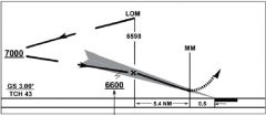
In the chart, the number 6600 depicts the ______ altitude. A. Decision height B. minimum glideslope intercept C. minimum descent D. procedure turn |
B. minimum glideslope intercept |