![]()
![]()
![]()
Use LEFT and RIGHT arrow keys to navigate between flashcards;
Use UP and DOWN arrow keys to flip the card;
H to show hint;
A reads text to speech;
104 Cards in this Set
- Front
- Back
|
Front (Term) Urbanization |
Back (Definition) The process by which the population of cities grows what |
|
|
Front (Term) What are the two dimensions of urbanization? |
Back (Definition) 1. Increase in the number of people living in cities 2. Increase in the percentage of people living in cities |
|
|
Front (Term) About how many people live in urban areas in MDC's? |
Back (Definition) About 3/4 |
|
|
About how many people live in urban areas in LDC's? |
About 2/5 |
|
|
What is the only LDC region that is comparable to MDC's when it comes to people living in urban areas? |
Latin America |
|
|
Why is the percentage of urban dwellers high in MDC's? |
Over the past 200 years rural residents have migrated from the countryside to work in the factories and services that are concentrated in cities |
|
|
What are the top 10 most populous cities in the world? |
1. Buenos Aires 2. Delhi 3. Dhaka 4. Jakarta 5. Kolkata (Calcutta) 6. Mexico City 7. Mumbai (Bombay) 8. São Paulo 9. New York 10. Tokyo |
|
|
What accounts for 3/4 of the urban growth in Africa. |
A high natural increase rate (NIR) |
|
|
What are the 3 characteristics that Louis Wirth define that cities as permanent settlements have? |
1. Large size 2. High population density 3. Socially heterogenous people |
|
|
What type of relationships are made in urban areas? Rural? With examples. |
Urban- contractual; your supervisor, your lawyer
Rural- closer relationship, relatives; the same people you see all the time in local shops and in churches |
|
|
According to Wirth, what is the only way a large number of People be supported in a small area? |
Specialization |
|
|
Specialization |
Each person in an urban settlement plays a special role or performs a specific task to allow the complex urban system to function smoothly |
|
|
What does high density in an urban area encourage? |
It encourages people to compete for survival in limited space |
|
|
What does a person living in an urban settlement than in a rural settlement have more freedom to pursue? |
- unusual jobs - sexual orientation - cultural interest |
|
|
Even though there is more freedom and independence, some people may still feel what ? |
Lonely and isolated |
|
|
What manufactured items have also reduced the differences between rural and urban lifestyles in MDC's? |
Nearly universal ownership of automobiles, telephones, televisions and other modern communications and transportation |
|
|
City |
An urban settlement that has been legally incorporated into an independent, self-governing unit |
|
|
What are main things that a city has? |
- Locally elected officials - ability to raise taxes - responsibility for providing essential services |
|
|
What do the boundaries of a city define? |
Defines the geographic area within which the local government has legal authority |
|
|
Central city (in the U.S.) |
A city surrounded by suburbs |
|
|
Urbanized area (Common (in the U.S.)and precise definition) |
Common- the central city and the surrounding built-up suburbs
Precise- consists of a central city plus its contiguous built-up suburbs where population density exceeds 1,000 persons per square mile |
|
|
What percentage of U.S. Population live in urbanized areas, central cities, and in surrounding jurisdictions? |
Urbanized areas- 70% Central cities- 30% Surrounding jurisdictions- 40% |
|
|
Why does and urbanized area have limited applicability? Give example also. |
It does not accurately reflect the full influence that an urban settlement has in contemporary society Example: commuters traveling a long distance to work in the cities or the built-up suburbs |
|
|
Metropolitan statistical area (MSA) |
1. An urbanized area with a population of at least 50,000 2. The county within the city is located 3. Adjacent counties with a high population density and a large percentage of residents working in the central cities county |
|
|
What is one problem of using MSA's for for measuring the functional area of a city? Provide example. |
Some MSA's include extensive land area that is not urban Example: Great Smoky Mountains National Park is partly in the Knoxville, Tennessee |
|
|
How much of the total U.S. Land area and population do MSA's comprise? |
Land area- 20% Population- 90% |
|
|
Micropolitain statistical area |
An urbanized area of between 10,000 and 50,000 inhabitants, the county in which it was found, and adjacent counties tied to the city |
|
|
What percentage of Americans live in a micropolitan statistical areas? |
10% |
|
|
In America, where are micropolitan statistical areas mostly found? |
Around southern and western communities |
|
|
What is the most important megalopolis? Who named the region? What is its common name? |
Extends from north of Boston to south of Washington D.C.
Jean Gottmann
Boswash corridor |
|
|
What are the 3 types of urban models and who was each created by? |
- concentric zone model: E.W. Burgess - sector model: Homer Hoyt - multiple nuclei model: C.D. Harris and E.L. Ullman |
|
|
Concentric zone model |
As a city grows outward from a central area in a series of concentric rings - five zones 1: CBD- non-residential activities are concentrated 2: zone of transition- contains industry & poorer-quality housing-- immigrants live here 3: working-class homes 4: middle-class homes 5: commuter zone--rich families - social patterns |
|
|
Sector model |
- Creator: Homer Hoyt - Developed: 1939 - How city develops: in a series of sectors, not rings - 1:CBD 2:transportation and industry 3:low-class residential 4:middle-class 5:high-class reaidential |
|
|
Multiple Nuclei Model |
- Creators: C. D. Harris and E. L. Ullman - Developed: 1945 - more than one center of which activities evolve - theory states that some activities are attracted to popular nodes, whereas others try to avoid them 1) CBD 2) wholesale, light manufacturing 3) low-class residential 4) medium-class residential 5) high-class residential 6) heavy manufacturing 7) outlying business district 8) residential suburb 9) industrial suburb |
|
|
Front (Term) Which model is this and name the numbers |
Back (Definition) Multiple Nuclei Model 1) CBD 2) wholesale, light manufacturing 3) low-class residential 4) medium-class residential 5) high-class residential 6) heavy manufacturing 7) outlying business district 8) residential suburb 9) industrial suburb |
|
|
Front (Term) Which model is this? What are the numbers? |
Back (Definition) 1: CBD- non-residential activities are concentrated 2: zone of transition- contains industry & poorer-quality housing-- immigrants live here 3: working-class homes 4: middle-class homes 5: commuter zone--rich families |
|
|
Which model is this? What are the numbers? |
Back (Definition) 1: CBD 2: transportation industry 3: low-class residential 4: middle-class residential 5: high-class residential |
|
|
Census tracts |
Contains about 5,000 residents and correspond, where possible, to neighborhood boundaries |
|
|
Social area analysis |
Comparing the distributions of characteristics and create an overall picture of where various types of people tend to live |
|
|
In precolonial cities how where cities often laid out? |
Surrounded a religious core |
|
|
Front (Term) Name of model |
Back (Definition) Latin American model squatter settlements |
|
|
Front (Term) Squatter settlements |
Back (Definition) Because of housing shortage, a large percentage of poor immigrants to urban areas in LDC's live in squatter settlements |
|
|
Other names for squatter settlements according to region |
- Latin America: barrios, barriadas, favelas - North Africa: bidonvilles - Turkey: gecekondu - India: bustees - Malaysia: kampongs - Philippines: barung-barong |
|
|
About how many people worldwide did the UN lived in squatter settlements in 2003 |
175 million |
|
|
Filtering |
The process of subdivision of houses and occupancy by successive waves of lower income people |
|
|
Redlining |
Drawing lines on a map to identify areas in which they will refuse to loan money |
|
|
Redlining |
Drawing lines on a map to identify areas in which they will refuse to loan money |
|
|
Urban renewal |
Cities identify blighted inner city neighborhoods, acquire the properties from private owners, relocate the residents and businesses, clear the site, and build new roads and utilities |
|
|
Public housing |
- reserved for low-income households, who must pay 30% of their income for rent - local government manages the buildings - federal government pays the cost of construction and the maintenance, repair, and management that are not covered by rent |
|
|
Gentrification |
The process by which middle-class people move into deteriorated inner-city neighborhoods and renovate the housing |
|
|
Underclass |
- inner-city residents - they are trapped in an unending cycle of economic and social problems |
|
|
What are the 4 social problems of inner-city residents? |
- lack of job skills - homelessness - crime - ethnic and racial segregation |
|
|
Annexation |
The process of legally adding land area to a city |
|
|
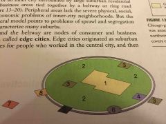
Peripheral model |
An urban area consists of and inner city surrounded by a large suburban residential and business areas tied together by a beltway or ring road |
|
|
Peripheral model |
An urban area consists of and inner city surrounded by a large suburban residential and business areas tied together by a beltway or ring road |
|
|
Edge cities |
The nodes of consumer and business services around the beltway |
|

Front (Term) Name model and name numbers |
Back (Definition) 1) central city 2) suburban residential area 3) shopping mall 4) industrial district 5) office park 6) service center 7) airport complex 8) combined employment and shopping center |
|

Front (Term) Name model and name numbers |
Back (Definition) 1) central city 2) suburban residential area 3) shopping mall 4) industrial district 5) office park 6) service center 7) airport complex 8) combined employment and shopping center |
|
|
Density gradient |
A density change in an urban area |
|
|
Sprawl |
The progressive spread of development over the landscape |
|
|
Zoning ordinances |
- developed in Europe and North America in the early 20th century - prevents the mixing of land uses within the same district |
|
|
Rush hour |
- "peak hour" - the 4 consecutive 15 minute periods that have the heaviest traffic |
|
|
Council of government |
A cooperative agency consisting of representatives of various local governments in the region |
|
|
Smart growth |
Legislation and regulations to limit suburban sprawl and preserve farmland |