![]()
![]()
![]()
Use LEFT and RIGHT arrow keys to navigate between flashcards;
Use UP and DOWN arrow keys to flip the card;
H to show hint;
A reads text to speech;
21 Cards in this Set
- Front
- Back
|
What is VFR met minima Vol1 ENR 1.2-2 |
8km vis 2km horizontal and 1000ft vertical clear of cloud Between 3000ft AMSL (or 1000ft AGL) and 10000ft AMSL 5km vis 2km horizontal and 1000ft vertical clear of cloud Below 3000ft (or 1000ft AGL 5km vis clear of cloud and in sight of surface CTR 5km vis 2km horizontal 500ft vertical clear of cloud |
|
|
VFR met minima at aerodromes Vol1 ENR 1.2-3 |
All aircraft day and night 1500ft ceiling 5km vis SVFR day 600ft ceiling 1500m vis Uncontrolled airfield: All aircraft day 600ft ceiling 1500m vis All aircraft night 1500ft ceiling 8km vis |
|
|
What separation is provided in class C Vol1 ENR 1.4-1 |
IFR separated from IFR, VFR and SVFR VFR separated from IFR, and receives VFR info SVFR separated from SVFR if vis less than 5km |
|
|
What separation is provided in class D Vol1 ENR 1.4-1 |
IFR and VFR permitted
IFR separated from IFR, and SVFR, gets VFR info VFR receives IFR and VFR info SVFR separated from SVFR if vis less than 5km Traffic avoidance is provided to IFR and VFR on request |
|
|
What tower clearances require readback Vol1 ENR 1.1-14 |
-ATC route / depart / approach clearances -VFR clearances to operate in CTA/CTR -Clearances and instructions to operate on manoeuvring area -Runway in use -SSR (Secondary Surveillance Radar) codes -Level, Heading, Speed instructions -ALT settings -Frequency instructions |
|
|
Definition of Urgency and Distress situations Vol1 ENR 1.15-1 |
Distress: Condition of being threatened by serious and/or imminent danger and requiring immediate |
|
|
What radio call is used in an urgency situation Vol1 ENR 1.15-2 |
"PAN PAN"x3 Name of station addressed ID of aircraft Nature of urgency Pilot intentions Present position, level, heading Additional info |
|
|
What radio call is used in an distress situation Vol1 ENR 1.15-1 |
"MAYDAY"x3 Name of station addressed ID of aircraft Nature of distress Pilot intentions Present position, level, heading |
|
|
VFR cruising altitudes Vol1 ENR 1.7-10 |
Odd thousands + 500ft above 3000ft AMSL / 1000ft AGL eg 3500ft, 5500ft, 7500ft, 9500ft South bound (90 - 269) Even thousands + 500ft above 3000ft AMSL / 1000ft AGL eg 4500ft, 6500ft, 8500ft, 10500ft |
|
|
When is clearance required between different air spaces? Vol1 ENR 1.1-12
|
All aircraft, helicopters, vehicles, equipment and pedestrians to operate in a manoeuvring area in a controlled aerodrome when ATC is in attendance
Required by IFR flights in class C or D and VFR flights in class C or D
|
|
|
Rights of way
|
Head-on alter course to right Converging aircraft to right has right of way / alter course to right Overtaking alter course right |
|
|
What are the special use airspaces? |
Restricted area: Entry only after authorization Danger area: Entry at own risk, assess dangers prior to entry Military operating area: Entry only after authorization Volcanic hazard zone: Entry only VMC by day Mandatory broadcast zone: Broadcast position, intentions on entering zones, circuit and runway |
|
|
What are the requirements for transponders? Vol1 ENR 1.4-3 |
All controlled airspace in New Zealand is Transponder Mandatory airspace, meaning XPDRs must be on in Mode A and Mode C unless otherwise approved by ATC. |
|
|
What are the avoidance requirements around sensitive areas?
|
1000ft vertical clearance or 1nm horizontal clearance
|
|
|
Vol1 ENR 5.5-6 |
A VFR Transit Lane is part of a CTR or CTA released as Class G airspace during daylight hours only to allow VFR aircraft to transit through airspace not normally used by IFR aircraft.
|
|
|
What is the difference between a CTR and a CTA?
|
CTRs are associated with aerodrome operations and are the only form of controlled airspace that touch the surface of the earth.
CTAs extend from a specified lower limit to a specified upper limit. Designed to encompass flight paths of IFR approach, departure and enroute operations.
|
|
|
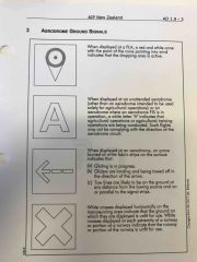
What are some ground signals at airfields? Vol1 AD 1.9-3
|
|
|
|
What are the different altimeter settings and when are they used? Vol1 ENR 1.7-3
|
QNH - aerodrome pressure corrected for mean sea level pressure. Altimeter reads height AMSL for a QNH zone, usually issued by ATC. Used when below 13000ft or descending through 15000ft.
QNE - pressure altitude above standard atmosphere pressure of 1013.25hPa. Used for flight levels above 13000ft AMSL.
QFE - Pressure altitude above aerodrome. Altimeter reads height AGL. Used for aerobatic displays at aerodromes. |
|
|
What are the requirements for a VFR flight plan? Vol1 ENR 1.10-23 |
A VFR flight plan is required prior to the start of any flight under VFR if: It is panned for the aircraft to proceed more than 50nm from shore; or An alerting service is required. Aircraft Registration Aircraft callsign Aircraft type Route details including destination SARTIME Fuel endurance Number of POB Other information Pilot in command Contact number Operator |
|
|
What are the emergency transponder codes?
|
7600 - Communication failure 7700 - Emergency |
|
|
What are the considerations when flying through overlapping airspaces? |
SUAs have priority over CTRs/CTAs Where different classes of airspace adjoin one above the other, flights at the common level will comply with the requirements of, and be given services applicable to the less restrictive class of airspace |