![]()
![]()
![]()
Use LEFT and RIGHT arrow keys to navigate between flashcards;
Use UP and DOWN arrow keys to flip the card;
H to show hint;
A reads text to speech;
39 Cards in this Set
- Front
- Back
|
How is IFR is diff to VFR? |
a. IFR is flight conducted IAW instrument flightrules b. VFR is flight conducted IAW visual flight rules |
|
|
How IMC differs from VMC, what terms mean to us
|
a. IMC means met conditions expressed in terms of visibility, distance from cloud and ceiling less than the minima specified forVMC b. VMC – better than the specified minima
|
|
|
Simulated IMC – how is it applied? |
a. Any portion of sortie flying with sole referenceto instruments (SOP 300 – need 2 crew members to simulate IMC) |
|
|
Not below altitudes - what they look like on plates |

|
|
|
whatterrain clearances our MSAs give us? |
i. 1000ft ii. 2000ftover mountainous terrain iii. 3000ftover volcanoes classified hazard level 1 |
|
|
What category are we? |
B. Nice one! |
|
|
How does our category (B) affect our circling approaches? |
a. Within 2.66nm from all thresholds b. This will give you 295ft min obstacle clearance c. Max circling speed 135KIAS d. There will be a Circling MDA on plate |
|
|
Separationbetween self and others in different types of airspace |
Class A – IFR from IFR Class C – IFR from IFR, VFR, SVFR (SVFR from SVFR when vis < 5km) Class D – IFR from IFR and SVFR, (SVFR from SVFR when vis < 5km) Class G - Not provided |
|
|
What are the Different methods of horizontal sep? |
a. Longitudinal – time based e.g. depart at spectime, lose time in transit, hold for spec time etc b. Lateral – maintaining outside area of conflictusing navaids and margin of error c. Radar d. Geographical – Geo references, under 6000ftonly, need to carry a VMC |
|
|
Under what conditions can you provide your own separation in VMC? |
You can provide your own separation from one other IFRflight in VMC provided that: 1. The pilot requests it 1. Class D airspace only 2. Day only 3. Radar control service is not available 4. During a climb/descent below 10,000ft AMSL 5. Other pilot agrees 6. Essential Traffic info is passed 7. Both a/cs are on the same ATC frequency |
|
|
What is MILSEP? |
Operations at less than the promulgated IFR separation minimums from other military ACs or formations. |
|
|
Whats the difference between primary and secondary radar, and what kind of separation they can give? |
-Primary: -Sends signal out, gets reflected and bounces back. -When radar separation is being applied between controlled flights, the minimum horizontal separation is 5NM (except where wake turb is a factor) -Secondary: -Sends signal out, Mode C/S transponder catches it, sends a reply back. -Sep may be reduced to 3NM when within 60nm of AA, Te Weraraiti, OH, WN, CH Also... -When two aircraft on reciprocal tracks have passed each other and their radar position symbols are separated (their blips no longer overlap on the screen), you are deemed to be separated. |
|
|
Radar vectors. What's all that about?! F**K! |
-Controller instructs the pilot to steer a mag heading -more than 180deg, will repeat turn direction twice - Rate 1 turns - "Radar Terrain" = they will provide you with terrain clearance, 1000ft nominal, 2000ft over mountainous areas. -Termination: will be told to resume own navigation. -Speeds could be specified. |
|
|
Radar cloud breaks. How do they work? |
- Radar controller vectors the aircraft into safe let down areas and clears the aircraft to descend to a specified minimum altitude using Radar terrain. - Crews should not request a radar cloud break unless reported ceiling is at least 2500ft. - Standard: get AC to 5nm finals or 3nm initials for B&B |
|
|
Purpose of IFR departures? |
- Allow IFR flights to safely depart an airfield in IMC - To get an aircraft going en route with minimal delay. |
|
|
Climb gradients. Minimum? Bordering two sectors? Crossing into a new sector? Prior to leaving an evaluated climb sector, you must be...? |
minimum = 3.3% (200ft/NM) Bordering two sectors - apply lowest Crossing into a new sector? Apply highest Prior to leaving an evaluated sector you must be: 1. Established on an evaluated route; or 2. Established on climb above VORSEC steps; or 3. Established under radar control at or above minimum radar terrain sep; or 4. At or above the approved area's MSA. |
|
|
EXTRA: 5 types of IFR departures? |
1. Visual departure (by day only, maintaining own terrain clearance visually to applicable MSA) 2. Published instrument departure (SIDs...) 3. Climb on track above DME or VORSEC chart steps (pie chart thing) 4. Specified track or radar heading within an evaluated climb sector 5. Radar control departure (i.e. vectoring) |
|
|
For a SID, Min/max speed? climb gradient? AOB? When can you commence turn? Obstacle clearance design? |
Max IAS = 165KIAS Min climb gradient = 3.3% AOB = 15deg Climb on centreline to 400ft before turn (unless different on plate) Obstacle clearance design: From a point 16ft above end of runway. |
|
|
Max IAS for a holding pattern? |
Below 14,000ft: 170kt 14,00 - FL200: 240kt FL200 - FL340: 265kt |
|
|
Approach speeds? |
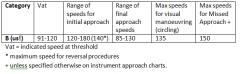
|
|
|
IOT to T/O in IF, What minima do we require? |
Needs to be at or above that specified in AD2. If not specified, standard mins apply: 300ft ceiling, 1500m vis. Reduced T/O min: 0 ceiling, 800m vis. Provided that: 1. RWY has centreline markings/lights 2. Vis is actually confirmed by the pilot 3. AD2 allows for reduced T/O minima. 4. Obstacles in flight path are taken into account 5. Multi engine, must have auto-feather system. |
|
|
Define MSA, MEA, MRA, MFA |
Minimum Safe Altitude: minimum altitude that will provide 1000ft obstacle clearance within 5nm of planned route (2000ft in mountainous areas) Minimum Enroute Altitude: Lowest altitude an AC can fly and receive adequate NDB signal Minimum Reception Altitude: Same but for VOR instead of NDB. Minimum Flight Altitude: Minimum altitude after taking into account the MSA, MRA, MEA, VHZ, Danger/Restricted areas, in compliance with IFR table of cruising levels (NOSE). |
|
|
How do IFR cruising levels work? |
-NOSE - IFR whole 1000's, VFR +500ft _Can request a non-standard (e.g. due weather) |
|
|
Transition Altitude? |
Transition altitude: 13,000ft Transition Layer: 13,000ft - FL150 Transition Level: FL150 or FL160 when less than 980hPa or within 20nm of Mt Cook |
|
|
Sequence of approach segments? |
Arrival Segment Initial Approach Segment Intermediate approach segment Final approach segment Missed approach segment. |
|
|
What kind of approaches can we fly in the Texan? |
ILS (our only precision approach) LLZ (LOC) VOR NDB RNAV Circling approach |
|
|
Define MDA/MDH |
Minimum Descent Altitude: Aspecified altitude (AMSL) in a non-precision approach or circling approachbelow which descent must not be made without the required visual reference. Minimum Descent Height: Aspecified height (above aerodrome elevation) in a non-precision approach or circling approachbelow which descent must not be made without the required visual reference. |
|
|
EXTRA: Define DA |
DA(precision approach; vertical guidance required): the point at which wemust “decide” to go around if we have not established our visual references.(DA = AMSL, DH = AGL). You can dip just below it because of the dope safetydesigns but be safe out there playas. |
|
|
What are the different types of hold entries? |
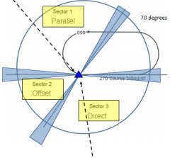
|
|
|
You are descending into an uncontrolled aerodrome in IMC. How low can you go in IMC before you have to be visual? |
Do not descend below 1200ft above aerodrome level (IOT avoid any circuit traffic below) if conflict with traffic is likely. |
|
|
How does remote QNH work? |
- Most aerodrome plates state 'USE (LOCAL) QNH' in order to get an accurate MDA for an instrument approach - However, some aerodromes don't have their own QNH - If so, you can use a QNH from another nearby aerodrome, but a correction must be applied: -Add 5ft to the MDA for every 1NM in excess of 5NM from the source QNH. Exampe: Wairoa to Napier = 35NM; therefore 35- 5= 30 x 5 = 150ft) For an instrument approach at Wairoa usingNapier QNH, add 150ft to MDA. -NB: Some aerodromes have limitations e.g. areas which are mountainous cannot use alternate QNH. |
|
|
When do you need to have an alternate? |
If forecast conditions at +/- 1 hr of ETA at destination is less than: - cloud ceiling 1000ft above MDA or DA - vis >5km or >2km more than the plate minema. |
|
|
What fuel do you require to get to an alternate? How much fuel would you need overhead your alternate prior to an approach and landing? |
-Diversion fuel. enough to do: 1. Missed approach at original destination 2. Transit to your alternate (calculated from flt man) 3. Do an approach (70lb) - Contingency fuel (= +5% of your 'Enroute Fuel' + 5% of your 'Diversion Fuel') And remember A/C captains are to plan to land with no less than 200lbs minimum landing fuel (100lbs minimum fuel + 100lbs for 15mins hold) So you must arrive overhead the alternate with 270lbs (200 minimum landing fuel + 70lbs for an approach) |
|
|
Describe PBN |
PBN is a shift from conventional ground-based navigational aids and procedures to satellite based navigation aids and area navigation procedures which are more accurate and allow for shorter, more direct routes. |
|
|
What is your position on the role of government in supporting innovation in the field of biotechnology? |
Recent research has shown that empirical evidence for globalization of corporate innovation is very limited and as a corollary the market for technologies is shrinking. As a world leader, it's important for America to provide systematic research grants for our scientists. I believe strongly there will always be a need for us to have a well-articulated innovation policy with emphasis on human resource development. Thank you. |
|
|
What do the different acronyms mean for lighting? REIL REDL RTHL RENL RTZL RCLL |

ALS - Approach lighting system REIL - Runway end identifier lights REDL - Runway edge lighting RTHL - Runway threshold lighting RENL - Runway end lighting RTZL - Runway touchdown zone lights RCLL - Runway centreline lights. |
|
|
More lighting... CGL PAL ABN LIH LIM LIL |
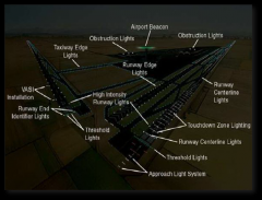
CGL - Circling guidance lighting PAL - pilot activated lighting ABN - Aerodrom Beacon LIH - Light intensity High LIM - Light intensity Medium LIL - Low |
|
|
How does pilot activated lighting work? |
-Details are on plate -Duration: 20 mins -Activated by: keying transmitter 5 times within 3 seconds (unless otherwise stated on plate) -10sec to warm up, then will start on max intensity -to change intensity or runway, repeat turn on sequence and hold down last transmission to cycle through intensity settings/ runway to use. -Reactivation: retransmitting resetes lighting timer for another 20mins -No warning for turn off |
|
|
What is the weather minima to nominate an aerodrome as an alternate for, 1. a precision approach? 2. A non-precision approach? |
Precision: Higher of -600ft cloud base or 200ft above DA -vis: 3000m or 1000m more than specified minima Non-precision approach: higher of: -800ft cloud base or 200ft above MDA -4000m vis or 1500m more than the specified minima on the plate. |