![]()
![]()
![]()
Use LEFT and RIGHT arrow keys to navigate between flashcards;
Use UP and DOWN arrow keys to flip the card;
H to show hint;
A reads text to speech;
24 Cards in this Set
- Front
- Back
|
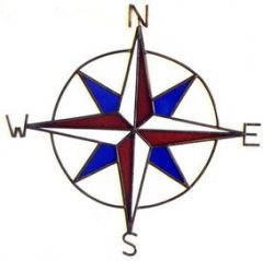
Compass Rose |

North arrow to show directions |
|
|
Cardinal Directions |
North, east, south, west |
|
|
Intermediate Directions |
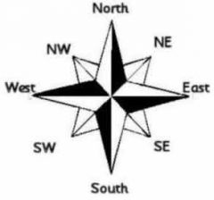
Northeast Southeast Northwest Southwest |
|
|
Scale Bar |
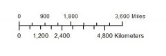
Scale bars tell you how far apart distances are on a map. Marked in miles |
|
|
Relative Location |
A location on a map compared to another location on a map |
|
|
Interdependance |
Dependence on other people Example: We depend on them for certain goods and services and they depend on us for certain goods and services |
|
|
Grid |
A set of vertical and horizontal lines used to identify locations on a map |
|
|
Cell |
On a grid, a cell is the area where a row and column meet |
|
|
Index |
A map has an index, which has all of the names of places listed on the map in alphabetical order |
|
|
Absolute Location |
The location on a map based on longitude and latitude measures Ex: Chicago: 41 N and 87 W |
|
|
Latitude |
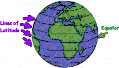
-Latitude lines are called parallels - They run east and west around the world. |
|
|
Longitude |
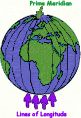
-Longitude lines are called meridans -They run north and south |
|
|
Degree |

-Longitude and Latitude are measure in degrees -The earth has 360 degrees around the sphere |
|
|
Equator |
-The equator is a line of latitude that splits earth into two equal parts and seperates the north and south poles. -Planet's line of zero degrees latitude |
|
|
Prime Meridan |
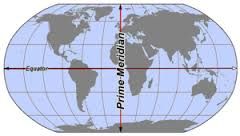
-Planet’s line of zero degrees longitude. -Slices the earth into the Eastern and Western Hemispheree |
|
|
How many continents are there? |
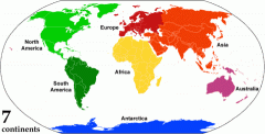
There are 7 continents |
|
|
Name the continents |
1. Africa 2. Antarctica 3. Asia 4. Australia 5. Europe 6. North America 7. South America |
|
|
How many oceans are on earth? |
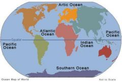
There are 4 oceans |
|
|
Name the four oceans on earth |
1. Pacific Ocean 2. Atlantic Ocean 3. Indian Ocean 4. Artic Ocean |
|
|
Symbol |
Symbols are used to distinguish different kinds of information on a map |
|
|
Legend |
The legend explains the symbols meanings on a map |
|
|
Axis |

The movement of the earth around the sun and the tilt of the earth |
|
|
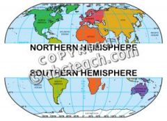
Northern Hemisphere |

-Part of the earth north of the equator |
|
|
Southern Hemisphere |

- Part of the earth south of the equator |