![]()
![]()
![]()
Use LEFT and RIGHT arrow keys to navigate between flashcards;
Use UP and DOWN arrow keys to flip the card;
H to show hint;
A reads text to speech;
54 Cards in this Set
- Front
- Back
- 3rd side (hint)
|
Five soil-forming factors |
Parent Material Climate Living organisms Landscape position Time |
|
|
|
Define "parent material" |
A variety of unconsolidated organic and mineral material in which soil formation begins. |
|
|
|
How does "climate" function as a soil-forming factor. |
Determines the kind of plant and animal life on and in the soil. It determines the amount of water available for weathering minerals and elements released. |
|
|
|
Define how "living organisms" act as a soil- forming factor. |
Plants supply upper layers with organic matter, recycling nutrients from lower areas. Deep rooted plans allow water movement, aiding in leaching. Animals and microorganisms eat and break down organic matter. Organisms convert certain elements like N and S into forms usable by plants. |
|
|
|
Define "landscape position" as a soil-forming factor. |
Landscape position causes localized changes in moisture and temperature. Drier soils at higher elevations evolve differently than wetter soils where water accumulates. Aspect affects soil temperature. |
|
|
|
Define "time" as a soil-forming factor. |
Time is required for horizon formation. The longer a soil surface has been exposed to soil forming agents, the greater the development of the soil profile. |
|
|
|
List the six master soil horizons. |
O - organic A - topsoil E - leaching zone B - zone of accumulation C - slightly developed parent material R - bedrock |
|
|
|
What is the chief characteristic of the O horizon? |
Fresh and decaying plant residue as well as animal organic material. |
|
|
|
What is the chief characteristic of the A horizon? |
The A horizon is mainly mineral material. It is generally dark due to varying amounts of humified organic matter. This is usually the most productive layer of soil. |
|
|
|
What is the chief characteristic of the E horizon? |
The main feature of this horizon is the loss of silicate clay, Fe, Al, humus, etc, leaving a concentration of sand and silt particles and a light color. May or may not be present below the A horizon (common in forest soils). Zone of eluviation. |
|
|
|
What is the chief characteristic of the B horizon? |
The B horizon is lighter colored, denser, and lower in organic matter than the A horizon. It is commonly the zone where leached materials accumulate (zone of illuviation). The B horizon is further defined by materials that make up the accumulation with subscripts which identify clay, Al, humus, carbonates, gypsum, or silica. |
|
|
|
What is the chief characteristic of the C horizon? |
C horizon may consist of less clay, or other less weathered sediments. Partially disintegrated parent material and mineral particles are in this horizon. |
|
|
|
Define soil texture. |
Texture is the relative proportion of soil separates in a soil. |
|
|
|
What is the size range of a sand separate? |
2.0 - 0.05 mm |
|
|
|
What is the size range of a silt separate? |
0.05 - 0.002 mm |
|
|
|
What is the size range of a clay separate? |
<0.002 mm |
|
|
|
What does the term "loam" mean? |
A loam is a soil featuring sand, silt, and clay. |
|
|
|
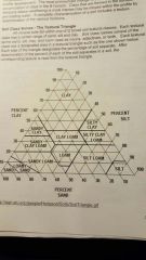
A soil is 35% sand and 40% silt. What is the texture? (See hint for triangle) |
Clay loam. |
|
|
|
(Feel and suspension method) A soil sample makes a 6 cm ribbon. Which texture might it be? A) sand B) silty clay C) loamy sand D) silt loam |
B. If the ribbon achieves 5 cm or longer before breaking, it is classified as a type of clay. |
|
|
|
Describe how to determine soil texture by specific gravity separation (hydrometer method). |
Using Stoke's Law we can determine the time for all particles for a particular size class to fall past a certain depth in a cylinder of water. The hydrometer measures the density of the particles still present above this depth. Hydrometer readings at calculated time intervals allow the calculation of the percentage of sand, silt, and clay in a sample. |
|
|
|
What is Stoke's Law? |
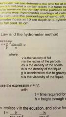
Stoke's Law states that when particles of equal density are suspended in a liquid, they will fall at a velocity proportional to their size. |
|
|
|
The 40 second hydrometer reading will give you data on which class(es) of soil separate? |
Silt and clay. |
|
|
|
The 6 hour, 52 minute hydrometer reading will give you data on which class(es) of soil separate? |
Clay. |
|
|
|
Given a 40 second hydrometer reading of 10 grams and a 6:52 reading of 5 grams, what is the percent of sand; 50g total soil in 1L of water. |
10 grams at 40 seconds indicates 10/50 or 20% silt and clay, therefore, 80% sand. The 5 grams at 6:52 indicates 10% clay. |
|
|
|
Define "bulk density". |
Bulk density is the dry mass per total volume of soil. |
|
|
|
Define "particle density". |
Particle density of a soil is the mass per unit volume of soil solids. |
|
|
|
Define "soil porosity" (as a measurement) |
Soil porosity is the proportion of the volume occupied by the pores relative to the total soil volume. |
|
|
|
Define "volumetric water content". |
Volumetric water content is the volume of water per total volume of soil. |
|
|
|
List five ions that contribute to cation exchange capacity. |
Na+ Ca2+ Mg2+ K+ (NH4)+ |
|
|
|
What is the role of ammonium acetate in determining CEC? |
The ammonium ion replaces the cations in the soil, separating them, and allowing the flame photometer to measure the concentration of the specific cation. |
|
|
|
How does CEC help maintain a nutrient balance in the soil? |
Basic cations are adsorbed to charged portions of the soil complex. They can be exchanged into the soil solution and can become available for plant use. For this reason, CEC is a measure of the soil's ability to hold nutrients. |
|
|
|
What is exchange acidity? |
The amount of acid cations (H+, Al+) occupied on the CEC. |
|
|
|
What is a "seepage lake"? |
A seepage lake is a natural lake fed by precipitation, limited runoff, and ground water. It does not have an outlet. |
|
|
|
What is a "ground water drainage lake"? |
A ground water drainage lake is a natural lake fed by ground water, precipitation, and limited runoff. It has a stream outlet. |
|
|
|
What is an "impoundment lake"? |
An impoundment lake is a man made lake created by damming a stream. It is also drained by a stream. |
|
|
|
What is of contaminant concern regarding a seepage lake? |
If precipitation is the major water source, acid from precipitation is a concern. If groundwater is the major water source, local septic systems or other groundwater contamination could cause problems. Runoff could continue contaminants as well. |
|
|
|
What are the contaminant concerns in a stream-fed lake? |
Nutrient levels can be high. Runoff and human activity in the watershed are of concern. |
|
|
|
At what temperature is water most dense? |
4°C |
|
|
|
What are the three zones of a stratified lake? |
Epilimnion: top layer. Warmest in summer, coldest in winter. Metalimnion or thermocline: middle zone, rapid temperature change with depth. Hypolimnion: bottom zone. Coldest in summer, ~4°C in winter. |
|
|
|
Define "dissolved oxygen". |
Amount of oxygen in water in mg/L = ppm |
|
|
|
Define "% saturation of dissolved oxygen" |
The concentration of dissolved oxygen contained in water compared to the concentration of dissolved oxygen the water could hold at a specified temperature and pressure. |
|
|
|
Define "specific conductance". |
Measure of water's ability to conduct electricity as a result of dissolved ions. |
|
|
|
What effect does temperature have on dissolved oxygen? |
Oxygen is more soluble in water at lower water temperatures. |
|
|
|
Why might the deepest part of the lake have low dissolved oxygen in the middle of summer, while the upper part of the lake is well-oxygenated? |
Despite the ability of cold water to hold oxygen, the deepest part of the lake will not receive sunlight, therefore will not produce oxygen through photosynthesis. The organisms decomposing organic material also raise the biological oxygen demand. The warm water at the top of the lake will become oxygenated by wind and wave action. |
|
|
|
What is GIS? |
Geographic Information System is a large database of spatial and geographical data. It integrates, stores, edits, analyzes, shares, and displays geographic information. |
|
|
|
How is stream order designated in Horton's classification system? |
A headwater is designated 1. A confluence of first-order streams leads into a 2. Two second-order streams would create a 3. A confluence of streams with different numbers would retain the largest number. |
|
|
|
What is the formula for drainage density? |
Total length of streams in basin (km) ÷ area of the basin (km^2). The units of the result are km^-1 |
|
|
|
What is a confined aquifer? |
An aquifer sandwiched between impervious or slowly permeable materials. |
|
|
|
What is an unconfined aquifer? |
An aquifer that has no confining layer between the land surface and the saturated zone. |
|
|
|
Define "water table". |
The top of the saturated zone in an unconfined aquifer. |
|
|
|
Define "potentiometric surface". |
This is the level to which water would rise in an unpumped well put into a confined aquifer. |
|
|
|
Define "cone of depression". |
The feature that appears when water is being removed from an aquifer at a faster rate than it is being replenished. |
|
|
|
Define "hydraulic head". |
It is the sum of the pressure from the weight of overlying water and the potential energy resulting from elevation. |
|
|
|
Define "hydraulic gradient". |
The difference in hydraulic head at two different points in an aquifer. dh/dl |
|