Reading...
![]()
Play button
![]()
Play button
![]()
Use LEFT and RIGHT arrow keys to navigate between flashcards;
Use UP and DOWN arrow keys to flip the card;
H to show hint;
A reads text to speech;
52 Cards in this Set
- Front
- Back
|
Infiltration
|
Absorption and downward movement of precipitation into the soil and regolith
|
|
|
Runoff
|
Flow of water from continents to oceans through stream flow and ground-water flow.
|
|
|
Ground water
|
Subsurface water in the saturated zone that moves under the force of gravity.
|
|
|
Water table
|
Upper limit of the body of ground water; marks the boundary between the saturated and unsaturated zones.
|
|
|
Aquifer
|
Layer of rock or sediment that contains abundant freely flowing ground water.
|
|
|
Stream
|
Long, narrow body of flowing water moving along a channel to lower levels under the force of gravity.
|
|
|
Drainage system
|
A branched network of stream channels and adjacent land slopes converging to a single channel at the outlet.
|
|
|
Overland flow
|
Runoff that flows down the slopes of the land in broadly distributed sheets.
|
|
|
Floodplain
|
A broad belt of low, flat ground bordering a river channel that floods regularly.
|
|
|
Lake
|
Body of standing water that is enclosed on all sides by land.
|
|
|
Stream flow
|
Water runs along a narrow channel between banks.
|
|
|
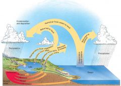
Explain the hydrologic cycle.
|
|
|
|
How are karst landscapes created?
|
Water slowly erodes limestone below the surface, forming deep underground caverns. The caverns can then collapse, creating a unique type of landscape. When the caverns collapse they are called sinkholes. (11.7)
|
|
|
Explain how ground water can become contaminated from waste.
|
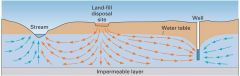
When waste is situated in the unsaturated zone, it reacts with rainwater that infiltrates the ground surface. This water picks up a wide variety of chemical compounds from the waste and carries them down to the water table.
|
|
|
How do wells affect the water table?
|
Wells lower the water table because they pump water out faster than the water table is recharged by water infiltrating downward.
|
|
|
How does a drainage system work?
|
As runoff moves to lower and lower levels and eventually to the sea, it becomes organized into a branched network of stream channels. This network and the sloping ground surfaces next to the channels that contribute overland flow to the streams together are called a drainage system.
|
|
|
How do salt flats form?
|
In lakes with no outlet, streams bring water in with dissolved solids. Since evaporation only removes pure water, the salts remain behind. Salt flats form when the climate encourages evaporation rather than input into the lake. The dry lake is then a shallow empty basin covered with salt deposits instead of a lake.
|
|
|
What percent of the hydrosphere's total water is fresh water?
|
3%
|
|
|
Where is most of the fresh water found?
|
Locked into ice sheets and mountain glaciers.
|
|
|
What are the three primary paths that precipitation can take after hitting the soil layer?
|
1. Infiltration 2. Surface runoff 3. Evapotranspiration
|
|
|
Evapotranspiration
|
a term describing the transport of water into the atmosphere from surfaces, including soil (soil evaporation), and from vegetation (transpiration).
|
|
|
Percolation
|
When the water on the surface of the earth seeps down underground
|
|
|
What happens when the water table remains stable?
|
The flow of water released to streams and lakes balances the flow of water percolating down into the water table.
|
|
|
Aquiclude
|
An impermeable body of rock or stratum of sediment that acts as a barrier to the flow of groundwater.
|
|
|
Artesian well
|
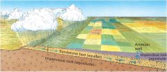
A porous sandstone bed (aquifer) is sandwiched between two impervious rock layers (aquicludes). Precipitation provides water that saturates the sandstone layer. Since the elevation of the well that taps the aquifer is below that of the range of hills feeding the aquifer, pressure forces water to rise in the well.
|
|
|
Karst
|
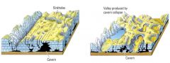
Landscapes where there are numerous sinkholes and no small surface streams.
|
|
|
Cone of depression
|

The depression in the water table around a well defining the area of influence of the well. (See 11.12)
|
|
|
Drawdown
|

The difference in height between the cone tip and the original water table. (See 11.12)
|
|
|
Explain how ground water can become contaminated from saltwater.
|
Fresh water is less dense than saltwater, so a layer of saltwater from the ocean can lie below a costal aquifer. When the aquifer is depleted, the level of saltwater rises and eventually reaches the well from below, making the well unusable.
|
|
|
Sheet flow
|
Where the soil or rock surface is smooth and the flow is a continuous thin film. *form of overland flow
|
|
|
Stream channel
|
A narrow trough, shaped by the forces of flowing water.
|
|
|
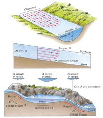
If a stream channel is straight and symmetrical, where is the line of maximum velocity?
|
Midstream, because water of the outer ends of the stream are slowed by the friction with the channel walls.
|
|
|
If a stream channel is curved, where is the line of maximum velocity?
|
Toward the bank on the outside of the curve.
|
|
|
What will the stream channel be like in stretches of rapids?
|
Narrow and shallow.
|
|
|
Drainage divide
|
The boundary between slopes that contribute water to different streams or drainage systems.
|
|
|
Drainage basin or watershed
|
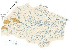
The pear-shaped drainage divide that bounds the entire drainage system.
|
|
|
In what two ways does the growth of cities and suburbs cause flooding?
|
1. When cities are built, the ground is covered with buildings and pavements. Water cannot infiltrate this material so overland flow increases, making flooding more common during heavy storms. 2. Storm sewers carries storm runoff from paved areas directly to streams through large underground pipes. This shortens the time it takes runoff to travel to channels while the proportion of runoff is increased by the expansion in impervious surfaces. Together, these changes reduce the lag time of urban streams and increase their peak discharge levels.
|
|
|
What happens when the discharge of a river cannot be accommodated within its normal channel?
|
Water spreads over the adjoining ground.
|
|
|
Lakes can disappear by what two processes (or a combination of both)?
|
1. Lakes that have stream outlets will be gradually drained as the outlets are eroded to lower levels. 2. Climate changes- if precipitation is reduced, or temperatures and net radiation increase, evaporation can exceed input and the lake can dry up.
|
|
|
In the U.S., what percent of the groundwater used for drinking comes from karst aquifers?
|
40%
|
|
|
What are six types of groundwater abuse?
|
1. excessive pumping 2. Rapid withdrawal 3. streamflow depletion 4. land subsidence 5. saltwater intrusion 6. anthropogenic contamination.
|
|
|
When does land subsidence occur?
|
Land subsidence occurs when large amounts of ground water have been withdrawn from certain types of rocks, such as fine-grained sediments. The rock compacts because the water is partly responsible for holding the ground up. When the water is withdrawn, the rocks falls in on itself.
|
|
|
What is streamflow depletion?
|
The amount of water that flows into a valley, or onto a particular land area, minus the water that flows out the valley or off from the particular land area
|
|
|
Effluent streams
|
Streams that get their water from the groundwater.
|
|
|
Influent streams
|
Streams that the water from the stream goes into the water table.
|
|
|
What regions are effluent streams found in?
|
Humid
|
|
|
What regions are influent streams found in?
|
Arid
|
|
|
What problems are associated with groundwater mining?
|
Groundwater mining exceed ability to recharge and collapses aquifers.
|
|
|
How does groundwater mining collapse aquifers?
|
There is a loss of support of water in pore spaces.
|
|
|
What are some examples of collapsed aquifers in the United States?
|
Ogallala Aquifer, Great Plains Aquifer.
|
|
|
What is a point source?
|
place where pollution occurred- someone goes out and dumps a pollutant at a particular spot
|
|
|
In the U.S. what causes the highest concentrations of groundwater pollution?
|
1. Agricultural runoff (animal feces, pesticides, etc) 2. old sanitary landfills
|