![]()
![]()
![]()
Use LEFT and RIGHT arrow keys to navigate between flashcards;
Use UP and DOWN arrow keys to flip the card;
H to show hint;
A reads text to speech;
41 Cards in this Set
- Front
- Back
- 3rd side (hint)
|
Speed Limit Below 10000 ASL
|
250 kias
|
|
|
|
Speed Limit Below 3000 AGL Within 10 nm of a controlled airport.
|
200 kias
|
|
|
|
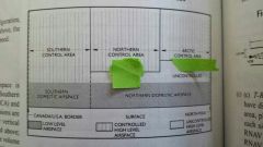
Main difference between Northern and Southern domestic airspace
|
True vs Magnetic track determines cruise altitude order
|
Magnetic Compass Reliability
|
|
|
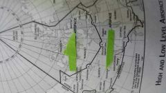
3 Areas of High Level Controlled Airspace
|
Southern Control Area
Northern Control Area Arctic Control Area |

|
|
|
Vertical Dimensions of the 3 High Level Controlled Areas
|
Southern Control Area >18000 ASL
Northern Control Area >FL230 Arctic Control Area >FL270 |
|
|
|
General Controlled Low Level Airway Dimensions by Altitude
|
2200ft AGL up to 17999 ASL
|
Within the boundaries of a VHF/UHF or LF/MF or Fixed RNAV Airway or Control Area Extension unless otherwise stated. Answer is an altitude AGL at the bottom extending upwards but not including an altitude ASL.
|
|
|
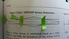
VHF/UHF Lateral Airway Dimensions VOR to VOR
|
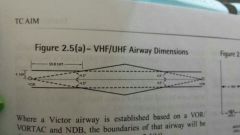
4 nm on Either Side
*where applicable lines diverging 4.5° on each side of the centerline from the designated facilities |
|
|
|
VHF/UHF Airway Lateral Dimensiona based on VOR and NDB
|

4.34nm of either side of the centerline prescribed for such an Airway and increased between lines diverging 5° from the facility
|

|
|
|
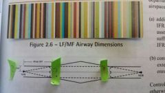
LF/MF Lateral Airway Dimensions
|

4.34nm on each side of the centerline and where applicable increased where lines 5° on each side of the centerline from the designated facilities intersect the basic width.
|
|
|
|
Control Area Extension (Purposes)
|
- Additional Airspace for separation around buzy control zones.
- To connect a control zone to the en route structure. |
2200ft AGL up to but not incl 18000ft ASL
|
|
|
Control Zone (Main Purpose)
|
Keeps IFR aircraft within controlled Airspace during approaches.
|
|
|
|
Control Zone (Dimensions)
|
7 NM and 3000' unless otherwise stated
Class B to E. |
|
|
|
VFR Wx Minima in Controlled Airspace
|
Visibility 3sm
Clouds 1 mile Horizontally and 500 ft Vertically |
|
|
|
VFR Wx Minima in Uncontrolled Airspace Abv 1000ft AGL
|
Visibility 1sm day 3sm night
Distance 2000' Horizontally and 500' Vertically |
|
|
|
VFR Wx Minima in Uncontrolled Airspace Below 1000ft AGL (Fixed wing)
|
Visibility 2sm day 3sm night
Clear of Cloud |
|
|
|
Special VFR Wx Minima
|
Visibility 1sm
Clear of Cloud |
|
|
|
VFR OTT Wx Minima Enroute
|
5sm Visibility
Vertically 1000ft ontop and min 5000 ft between layers of Cloud. |
|
|
|
VFR OTT Wx Minima at Destination served by TAF
|
5sm Visibility
No ceiling No forecasted precipitation, fog, thunder, or blowing snow 1h prior and 2h after ETA |
|
|
|
VFR OTT Wx Minima at Destination not served by TAF
|
5sm Visibility
No ceiling No forecasted precipitation, fog, thunder, or blowing snow 1h prior and 3h after ETA |
|
|
|
Class A Airspace Requirements
|
-IFR Only
-18000ft ASL in the Southern Control FL230 Northern Control Area FL270 Arctic Control Area FL600 Tops -XPDR Mode C |
|
|
|
Class B Airspace Requirements |
-Clearance & -Controlled VFR |
|
|
|
Class C Airspace Requirements
|
-Clearance and listening watch
-XPDR Mode C (NORDO VMC Day Only Call Ahead) -IFR Separation and IFR/VFR conflicts resolution. |
|
|
|
Class D Airspace Requirements
|
-2 way communication and a continuous listening watch.
-XPDR Mode C if specified as XPDR Airspace. -IFR Separation Only (IFR/VFR conflict resolution on request workload permitting) |
|
|
|
Class E Requirements |
-Controlled. No special VFR requirements unless specified as XPDR Airspace (VFR follow MF proc and get traffic advisory 5m prior to entry) |
Low Level Airways, Control Area Extensions, Transition Areas, or control Ones without an operating control tower may be Class E |
|
|
Class F Advisory |
-IFR "not permitted" or cleared through except on visual or contact appr, prior permission -126.7 unless otherwise stated |
-CY indicates Canada |
|
|
Class F Restricted
|
No person may conduct aerial activities within active Class F Restricted air space, unless prior permission has been obtained from the user agency.
Class F Areas by NOTAMs must be issued 24h in advance and for short durations |
Forrest Fires, Airshows
|
|
|
Class G Airspace
|
-No ATC authority
-All Uncontrolled Domestic Airspace -Low level air routes |
|
|
|
Altimeter Setting Region
|
Below 18000ft ASL
Set to Nearest station along route |
|
|
|
Standard Pressure Region
|
General - 29.92 on Altimeter
Transition - make changes in standard pressure regions Departure - Prior to takeoff set to current Altimeter Setting or elevation. Climb - 29.92 immediately prior to reaching altitude or thru 18000ft. Arrival - Prior to descent set current alt setting for destination or approaching 18000ft provided no hold is anticipated. Known Hold - Prior to descent out of lowest holding Flight Level |
|
|
|
MOCA at Mountainous Regions 1 and 5 |
2000ft Abv highest obstacle within 5sm |
BC and Baffin Island |
|
|
Standard RNP Enroute Accuracy
|
2NM from centreline Enroute
|
|
|
|
Standard RNP Terminal Accuracy Limits
|
1 NM from centreline in Terminal
|
|
|
|
Standard RNP Approach Accuracy Limits
|
0.3NM Final Approach
|
|
|
|
Air Route Class
|
G extending from the surface
|
|
|
|
Within 40 miles of Radar, ATC can provide a minimum of __ miles of separation between aircraft |
3 miles (5 outside) |
|
|
|
A pilot complying with a speed adjustment is expected to maintain the assigned speed within +/- _______ |
+/-10 KIAS |
|
|
|
When a track changes direction by more than . . . . . overhead navigation aids while flying at or above . . . . . extra airspace will be protected for the turn. |
15 Degrees |
|
|
|
Lowest usable flight level with altimeter setting 27.92-28.91 |
FL200 |
When altimeter setting is less than 29.92 there will be less than 1000' separation between aircraft at 18000' |
|
|
Areas with 2000 foot obstacle clearance |
AMA within DMR 1 and 5 Certain Radar Vectoring Areas within DMRs Airways and air routes within DMR 1 and 5 with the exception of certain segments which are used in the arrival and departure segment of flight |
|
|
|
ATC Clearance Thru Class F - When |
-Contact or visual approach -ALTRV APVL (Altitude reservation apprvd) -Pilot states permission has been obtained from user agency |
|
|
|
IFR AC using non active rwys at Uncontrolled Airports |
Allowed provided appropriate communication between pilots is established |
|