![]()
![]()
![]()
Use LEFT and RIGHT arrow keys to navigate between flashcards;
Use UP and DOWN arrow keys to flip the card;
H to show hint;
A reads text to speech;
150 Cards in this Set
- Front
- Back
|
Air mass 1 |
Homogeneous body of air with relatively uniform temperature and moisture characteristics of thesource region |
|
|
Air mass 2 |
Large volume of air over a relatively flat region acquire thermal and moisture properties consistent with the underlying surface for anextended period of time. |
|
|
Air mass 3 |
Air over the Gulf of Mexico: Warm and humid |
|
|
Air mass 4 |
Air over the Northern Canada: Frigid and bone-dry |
|
|
Classifying Air Masses 1 |
cA continental Arctic |
|
|
Classifying Air Masses 2 |
cP continental Polar |
|
|
Classifying Air Masses 3 |
cT continental Tropical |
|
|
Classifying Air Masses 4 |
mT maritime Tropical |
|
|
Classifying Air Mass 5 |
mP maritime Polar |
|
|
Air Mass Characteristics 1 (1. Source Region, 2. Polar, 3. Tropical) |
1. Land or Continental 2. Cold 3. Hot |
|
|
Air Mass Characteristics 2 (1. Source Region, 2. Polar, 3. Tropical) |
1. Land or Continental 2. Dry 3. Dry |
|
|
Air Mass Characteristics 3 (1. Source Region, 2. Polar, 3. Tropical) |
1. Land or Continental 2. Stable aloft, 3. Unstable at surface |
|
|
Air Mass Characteristics 4 (1. Source Region, 2. Polar, 3. Tropical) |
1. Water or Maritime 2. Cool 3. Warm |
|
|
Air Mass Characteristics 5 (1. Source Region, 2. Polar, 3. Tropical) |
1. Water or Maritime 2. Moist 3. Moist |
|
|
Air Mass Characteristics 6 (1. Source Region, 2. Polar, 3. Tropical) |
1. Water or Maritime 2. Can be stable 3. Typically unstable. |
|
|
Air Mass Characteristics 7 |
Air masses are 3-DNot all air masses are in contact with the ground |
|
|
Cold Front and the stability of the air 1 |
The type of precipitation depends on the stability of the warm air ahead of the front. |
|
|
Cold Front and the stability of the air 2 |
T-storm. Usually a line of T-stroms (squall line) along thefront. Sometime supercell T-storms with tornados, hail anddamaging wind. |
|
|
Cold Front and the stability of the air 3 |
Light rain or no rain at all. |
|
|
Cold Front and the stability of the air 4 |
Regardless of the cloud formations, cold front refers tocold air advancing, lifting warm air ahead of it |
|
|
Warm Front and the stability of the air 1 |
The type of precipitation depends on the stability of the warm air. |
|
|
Warm Front and the stability of the air 2 |
Wide spread of cloud will develop. The cloud are deepest near the front and becomethinner and higher away from the front. |
|
|
Warm Front and the stability of the air 3 |
Pressure is heaviest closer to the frontal boundary, and lighter where cloud are shallow. |
|
|
Warm Front and the stability of the air 4 |
T-storm, and the cloud is layered. |
|
|
Warm Front and the stability of the air 5 |
Regardless of the cloud formations, warm front refersto cold air retreating and warm air advancing. |
|
|
Comparison of cold and warm fronts 1 |
Cold fronts have steeper “slope” than warm fronts. |
|
|
Comparison of cold and warm front 2 |
Cold fronts advances faster than warm front |
|
|
Comparison of cold and warm front 3 |
Cold fronts cause more violent weather -cumulonimbus clouds |
|
|
Comparison of cold and warm front 4 |
Cold fronts cause short, sharp showers, whereas warm fronts causedrizzle or steady rain |
|
|
Comparison of cold and warm front 5 |
Warm fronts cover a wider area with clouds and precipitation |
|
|
Comparison of cold and warm front 6 |
Cold air is always ‘the boss’—its movement relative to the frontdetermine the type of front. |
|
|
Occluded front 1 |
Cold front meets the warm front ahead of it, that segmentbecomes occluded. |
|
|
Occluded front 2 |
Usually occur on mature and dissipating stages of an extratropicalcyclone |
|
|
Stationary Front and the stability of the air 1 |
A line of shower and thunderstorms may develop |
|
|
Stationary Front and the stability of the air 2 |
Heavy precipitation may persist leading to flooding. |
|
|
The Dryline 1 |
The dryline is a type of front. It is also termed the“dewpoint” front. |
|
|
The Dryline 2 |
It marks the boundary between moist Gulf ofMexico air and dry, warm desert air from thesouthwest. There is usually not a temperaturechange across the dryline. |
|
|
The Dryline 3 |
Most evident in south-central U.S. (TX, OK, KS) |
|
|
Fronts summary 1 |
1. Cold 2. Warm 3. Occluded 4. Dryline |
|
|
Fronts summary 2 |
Lower troposphere is comprised of air masses thatcontrast in T and/or humidity. Narrow transitionzone called fronts, border air masses. |
|
|
Fronts summary 3 |
Cold air is always ‘the boss’—its movementrelative to the front determine the type of front. Airretreats ahead of a warm front, advances behind acold front, and moves parallel to a stationary front.Cold front catches up warm front lead to occludefront. |
|
|
Fronts summary 4 |
Clouds and precipitation develop along the frontsonly when a significant density contrast existsbetween air masses. |
|
|
Fronts summary 5 |
With little difference in T and humidity between airmasses, the front may pass virtually unnoticedexcept a shift in wind direction |
|
|
Identifying Fronts: What to look for on a surface weather map or from own observations 1 |
Sharp temperature over a relatively short distance |
|
|
Identifying Fronts: What to look for on a surface weather map or from own observations 2 |
Change in moisture content |
|
|
Identifying Fronts: What to look for on a surface weather map or from own observations 3 |
Rapid shifts in wind direction (think about the center of lowpressure!) |
|
|
Identifying Fronts: What to look for on a surface weather map or from own observations 4 |
Pressure changes |
|
|
Identifying Fronts: What to look for on a surface weather map or from own observations 5 |
Clouds and precipitation patterns |
|
|
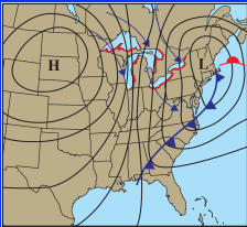
Extra-tropical Cyclones 1 |
Form along the jet stream between about 30-70°latitude. |
|
|
Extra-tropical Cyclones 2 |
They are the parent storms from which much of thesevere weather of the mid-latitudes develops. |
|
|
Extra-tropical Cyclones 3 |
Entire life cycle can span several days to well overa week, but can reach maximum intensity (i.e.,lowest central pressure) in as little as 36-48 hr afterformation. |
|
|
Extra-tropical Cyclones 4 |
These storms cover areas ranging from severalhundred to a thousand miles across. |
|
|
Extra-tropical Cyclone 5 |
Winds blow counter-clockwise (cyclonically) in NH |
|
|
Extra-tropical Cyclone 6 |
Winds spiral into low at surface |
|
|
Extra-tropical Cyclone 7 |
It forms, exists at intersection of fronts |
|
|
Extra-tropical Cyclone 8 |
Cold front to S and W, warm front to E of low |
|
|
Extra-tropical Cyclone 9 |
Cold air “behind” low, warm air “ahead” of low – lows & highs bothmove in direction of jet stream winds |
|
|
Extra-tropical Cyclone 10 |
Thunderstorms often ahead of cold front |
|
|
Extra-tropical Cyclone 11 |
Steady precipitation ahead of warm front (ice storms) |
|
|
Extra-tropical Cyclone 12 |
Cloud sequence of cirrus, cirrostratus, altostratus, nimbostratus |
|
|
Extra-tropical Cyclone 13 |
Life cycle of low: looks like huge sideways version of breaking oceanwave (lifetime: days to about 1 week) |
|
|
Extra-tropical Cyclone 14 |
Energy source: cold air ‘wants’ to be under warm air |
|
|
Extra-tropical Cyclone 15 |
Each cyclone is different from all others! |
|
|
Extra-tropical Cyclone: View from Above 1 |
A fully matureextratropical cyclone'scloud pattern looks like alarge “comma”. |
|
|
Extra-tropical Cyclone: View from Above 2 |

Severe weather occursalong the "tail" of the"comma" |
|
|
Extra-tropical Cyclone: View from Above 3 |

Heavy rain, snow, sleet,mixed precipitation occur withinthe "head" of the "comma" |
|
|
Extra-tropical Cyclone: View from Above 4 |

Blizzards occur (in winter)in the northwest quadrantof the "head" of the"comma" |
|
|
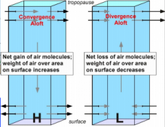
Upper level wave and convergence/divergence 1 |

|
|
|
Upper level wave and convergence/divergence 2 |
|
|
|
Upper level wave and convergence/divergence 3 |
|
|
|
Cyclone Development Regions in NA 1 |
just east of the Rockies in the central U.S. (particularly ineastern CO) |
|
|
Cyclone Development Regions in NA 2 |
just east of the Rockies in the central Canada (Alberta clipper) |
|
|
Cyclone Development Regions in NA 3 |
just off the TX-LA coastline along the Gulf Coast of the U.S. |
|
|
Cyclone Development Regions in NA 4 |
along the East Coast of the U.S. |
|
|
Cyclone Development Regions in NA 5 |
over the Bering Sea and Gulf of Alaska in the Pacific Ocean |
|
|
Intensity Difference 1 |
East and Gulf coast cyclones are often more intense that their (lee)Rocky Mountain counterparts. |
|
|
Intensity Difference 2 |
Latent heat released during condensation in the clouds contributes more tostorm intensification; local moisture source in the warm Gulf of Mexico andin the warm Gulf Stream current. |
|
|
Intensity Difference 3 |
Sensible heat from the ocean (gulf) surface acts to heat the atmosphere,contributing more to storm intensification; heat energy transferred directlyfrom water to air through conduction. |
|
|
Intensity Difference 4 |
Strong thermal contrasts between the ocean (gulf) and land enhance and maintain a sharp thermal boundary (i.e., baroclinic zone) along the coastline; most pronounced in winter. |
|
|
Intensity Difference 5 |
There is often more than one jetstreak acting to create upper-leveldivergence; the jetstreaks are found within two separate jetstreams (polar andsubtropical) and their "phasing" creates the strongest storms |
|
|
Intensity Difference 6 |
Friction is smaller over the ocean, which lead to weaker air convergenceinto the low-pressure center, allowing the low to maintain a greater intensity. |
|
|
"Bomb" |
Explosive cyclogenesis is called a "bomb": When extratropical cyclone deepens rapidly. 24 mb in 24 hr period. e.g., one case of 60 mb decrease in central pressure in24 h ==> 2.5 mb/h |
|
|
Ice Storms 1 |
Freezing rain and drizzle – freezes on surfacescausing glaze of ice. |
|
|
Ice Storms 2 |
Impacts public safety, insurance, economy,environment, power, and transportation |
|
|
Ice storms 3 |
Even minor events cause travel and walkingdifficulties. |
|
|
Ice storms 4 |
Aloft can cause icing on wings of airplanes. |
|
|
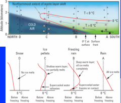
Supercooled water 1 |
Water melts at 0ºC, but does not necessarilyfreeze at this temp |
|
|
Supercooled water 2 |
Difficult to transition from moving fluid tosolid lattice of ice |
|
|
Supercooled water 3 |
Aerosols serve as ice nuclei in air |
|
|
Supercooled water 4 |
Ice nuclei most effective around 5ºF, marginally effective 5-23ºF, and hardly effective 23-32ºF. |
|
|
Supercooled water processes 1 |
Melting process – snow melts in warm layer,freezes on surface in shallow cold layer (deepclouds) => freezing rain |
|
|
Supercooled water processes 2 |
Supercooled warm rain process – collision andcoalescence of cloud droplets createsprecipitation, snow not involved (shallowclouds) => freezing drizzle, fog, or mist |
|
|
Supercooled water processes 3 |
Can also have freezing spray from water bodies. |
|
|
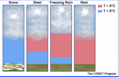
Vertical temperature profile and different type of precipitation |
|
|
|
Cross section through a warm front 1 |
|
|
|
Cross section through a warm front 2 |
|
|
|
Cross section through a warm front 3 |
|
|
|
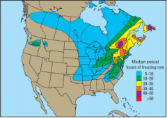
Freeze rain Climatology |
|
|
|
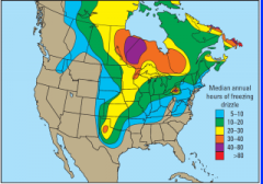
Freeze drizzle Climatology |
|
|
|
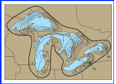
Lake-effect Snowstorms 1 |

Great Lakes, GreatSalt Lake, Aral Sea,and even ocean-effectsnow (Cape Cod,Outer Banks) |
|
|
Lake-effect Snowstorms 2 |

Within ~50 miles ofshoreline |
|
|
Lake-effect Snowstorms 3 |
1-5 feet in extremeevents |
|
|
Lake-effect Snowstorms 4 |

Can continue for days |
|
|
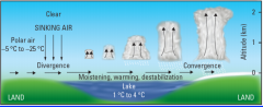
Synoptic Set-up 1 |
Very cold air movesover lake |
|
|
Synoptic Set-up 2 |

Extreme snow = verywarm lake temp. andvery cold air; tempgradient! |
|
|
Synoptic Set-up 3 |

Behind cold front withhigh pressure movingin |
|
|
Synoptic Set-up 4 |

Late fall and earlywinter (lakes warm andice free with cold airmasses) |
|
|
Synoptic Set-up 5 |

Concept of Delta-T |
|
|
Development - Wind 1 |

Air approaching lake is 23 to -13ºF. |
|
|
Development - Wind 2 |
Air accelerates over lake (less friction) |
|
|
Development - Wind 3 |

Divergence at upwind shore and convergence at downwindshore |
|
|
Development - Wind 4 |

Sinking air and clear skies upwind and rising air and clouds/precip. downwind |
|
|
Development - Moisture 1 |

Air warms and moistens over lake (capacityincreases as temp. increases), rapid evaporation |
|
|
Development - Moisture 2 |

Air at lake surface can warm up to 36ºF! |
|
|
Development - Moisture 3 |

Above warm surface layer, air remains cold => rapiddestabilization |
|
|
Climatology 1 |
Usually within 50 miles (80 km) of shore |
|
|
Climatology 2 |
Warm lake and cold air => LES |
|
|
Climatology 3 |
Large lake-air temp. difference => LES |
|
|
Climatology 4 |
T-diff > 10C, otherwise, the E and destabilizationare generally insufficient for lake-effect snow todevelop. |
|
|
Climatology 5 |
Frozen lake shuts off LES |
|
|
Blizzards: Why the Plains? Unique geography 1 |
Mountains block moderate Pacific air |
|
|
Blizzards: Why the Plains? Unique geography 2 |
Endless night produces bitter cold air that sweepsdown from Canada |
|
|
Blizzards: Why the Plains? Unique geography 3 |
Lee Cyclones bring wind and drag cold air down |
|
|
Blizzards: Why the Plains? Unique geography 4 |
Gulf of Mexico moisture fuels snow |
|
|
Ingredient - Cold Air 1 |
Originates on plains of west-central Canada inwinter |
|
|
Ingredient - Cold Air 2 |
Snow covered – radiates infrared energy, reflectssunlight |
|
|
Ingredient - Cold Air 3 |
Long winter nights |
|
|
Ingredient - Cold Air 4 |
Clear skies => radiational cooling |
|
|
Ingredient - Cold Air 5 |
Strong surface high develops => pressuregradient for wind |
|
|
Ingredient - Cold Air 6 |
-30 to -50 ºF |
|
|
Ingredient - Arctic Front 1 |
Leading edge of shallow, bitter cold air mass |
|
|
Ingredient - Arctic Front 2 |
Second surge of cold air behind polar front |
|
|
Ingredient - Arctic Front 3 |
Cyclones drag cold air southward |
|
|
Ingredient - Arctic Front 4 |
Colorado lows = more snow and wind; biggerstorms! |
|
|
Ingredient - Arctic Front 5 |
Alberta Clippers = colder temps.; dusting of snow. |
|
|
Ground Blizzards 1 |
Caused only by blowing snow |
|
|
Ground Blizzards 2 |
Skies may be clear |
|
|
Ground Blizzards 3 |
Frequent in Plains (usuallylocalized) |
|
|
Ground Blizzards 4 |
Drifting covers roads |
|
|
Ground Blizzard 5 |
Poor visibility |
|
|
Ground Blizzard 6 |
“Black ice” |
|
|
Ground Blizzard 7 |
Unexpected and dangerous |
|
|
Blizzard Safety 1 |
Drive carefully !!! Try not to get stranded or covered |
|
|
Blizzard Safety 2 |
Dress warmly |
|
|
Blizzard Safety 3 |
Beware of carbon monoxide |
|
|
Blizzard Safety 4 |
Fires, falling through ice, heart attacks |
|
|
Blizzard Safety 5 |
Winter storm survival kit in vehicle (blanket, flashlight,batteries, first aid kit, knife, food, water, dry clothes, potty(coffee can w/ lid), etc.) |
|
|
Blizzard safety 6 |
Winter supplies (sand, cat litter, shovel, booster cables,tools, etc.) |
|
|
Blizzard safety 7 |
STAY with vehicle !!! |
|
|
Blizzard safety 8 |
Carry cell phone. |