![]()
![]()
![]()
Use LEFT and RIGHT arrow keys to navigate between flashcards;
Use UP and DOWN arrow keys to flip the card;
H to show hint;
A reads text to speech;
42 Cards in this Set
- Front
- Back
|
Draw a wave dominated estuary diagram. label it. |
|
|
|
Draw a Tide dominated estuary and label. |
|
|
|
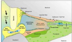
Describe a Tide-dominated estuary. Where formed? What energy levels? Sand Bars? Mixing? |
Forms on Meso/Macro/Megatidal coasts. Partially or fully mixed water. Tidal energy is greater than Wave energy. Elongate bars tidal sand bars form ~parallel to fluvial flow. |
|
|
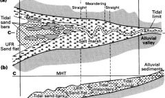
How does deposition occur in the tidal meanders of a Tide-Dominated estuary? What type of stratification is produced? |
Sand is deposited on point bars during Ebb and Flood tides. During Slack tide, mud is deposited creating Inclined Heterolithic Stratification. |
|
|
What is Inclined Heterolithic Stratification? How formed? How characterized? |
Alternating sand and mud deposits formed on a point bar. Indicates tide dominated estuary. Characterized by brackish ichno assemblages. |
|
|
How do you recognize Tide dominated Estuary deposits? |
1. IHS.. a) predominence of facies crossing elements eg trophic generalists. b) Low Diversity c) high BI index. Lots of food from tide and river. critters: planolites, thalassinoides,... 2. Abundance of Tide generated structures. Thin neap tide couples |
|
|
In what tidal zone do tidal flats form? Energy levels?
|
Meso/Macro/Mega-Tidal coasts in absence of strong waves.
- Open coast with low wave energy, - Behind barriers (reefs sand bars etc) on high energy coasts - Tide-dominated Estuaries - Tide-dominated Deltas |
|
|
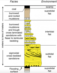
Describe physical features of Tidal Flats. What sediments do you find Where and Why are they there. What does Supratidal mean? |
Dips gently, disected by tidal creeks. Sub-total zone: below low tide line. Sand dept'd. Inter-tidal zone: between high and low tide lines. Sand dept'd in lower area, mud in higher zone. Supra-tidal zone: marsh zone gets we sometimes |
|
|
Describe/draw a tidal flat succession |
|
|
|
How to identify a Tidal flat succession |
1. Fining up succession 2. Predominance of tidal structures. 3. not Brackish. Fully moving? |
|
|
What is stratigraphy? |
large scale lateral and vertical relationships in sedimentary rock bodies |
|
|
Name7 types of stratigraphic correlations and what they correlate |
litho bio chrono sequence seismic magneto chemo |
|
|
What is basin analysis? |
integration of sedimentology, stratigraphy and fundamental tectonics to describe regional stratigraphic relationships.. |
|
|
What is the basis of lithostratigraphy? |
lithologic character of strata |
|
|
What makes a stratotype? |
Excellent example of strata in question
accessible for examination (can't be on top of everest only) used as comparison for other units if no outcrop, found in boreholes. may consist of a single or group of lithologies distinguishable from surrounding units |
|
|
What is a formation?
|
fundamental unit of lithostratigraphy
a lithologically distinctive unit that is large enough for mapping or tracing in sub surface. |
|
|
Name 5 different stratigraphic contacts and describe them (unconfomities etc..) |
1. Conformable contacts - can be gradational (grain sizes or intercalation different liths) or sharp (change in lith coincides with bedding plane)
2. Disconformities - Parallel strata with marked age difference 3. Angular unconformities 4. Nonconformities - volcanics or seds over crystalline rock 5. Paraconformities - period of non deposition (no erosional surface) between beds of greatly different ages. |
|
|
Why are unconformities such a big deal? |
Bound many stratigraphic successions - cannot apply Walthers law. indicate that a large erosional event occured (eg uplift and erosion) |
|
|
Name three lateral contacts and describe them. |
1. Pinch outs - progressive thinning and termination of beds.
2. Interfingering - laterally split into thin units each of which pinch out. 3. Gradational facies - eg gradation of sea bed approaching shoreline. Downlap. |
|
|
Define Diachronous |
lithologic unit that differs in age from place to place |
|
|
What does an unconformity indicate? |
The record is broken but somethingi big happened. Eg uplift & erosion, hiatus in deposition, increase energy in environment leading to higher rate of weathering... |
|
|
What is correlation? objective or interpretive? |
Correlation is an interpretation of characteristics of spatially separated strata to establish an equivalency of units across a large area. |
|
|
Name 3 common correlations and what they are based on. Are they diachronous? |
Lithostratigraphic Correlation -based on lithology -stratigraphic position (relative to surrounding) -Diachronous Biostratigraphic Correlationn -based on fossil content -less diachronous Chronostratigraphic Correlation -based on age of unit -includes Genetic Stratigraphy WE typically use a combo of these methods |
|
|
What are two methods to conduct lithocorrelation? Whats a handy tool to use?
|
1. Physically walk out the bed directly. Map it yourself = Direct correlation.
2. Match strata from separate sections = Indirect Correlation Marker Beds are used as controls on correlations (bounding etc). The more marker beds, the better! |
|
|
What are two problems with Lithostratigraphic Correlation? |
1. it can be Diachronous. 2. looking strictly at rock type does not lead to a detailed characterization of depositional environments, paleogeography, or understanding time frames. |
|
|
Define Datum as its used in stratigraphy. What qualities makes a good datum? |
Datum is a qualitative or quantitative characteristic found in a sedimentary sequence that is distinct, easily recognizable and wide spread over a geographic area that is used as a reference point for correlating a sequence over a wide area.
Ideally your datum is younger and close to the unit under examination. |
|
|
What is the basic principle of Biostratigraphy? How is relative age of units determined? |
Biostratigraphy is based on the principle of faunal succession wherein it is the understanding that organisms have undergone successive changes through time and that these changes can be preserved in predicable sequences. Relative Age of strata is determined from fossil content. |
|
|
What s a biozone? What is it based on? What is an index fossil? |
Biozones are the fundamental units of biostratigraphy. They are based on the stratigraphic ranges of fossils found in strata. Each biozone is named by a characteristic index fossil. Index fossils are widespread, abundant, and easily preserved fossils that exist for a short time range. |
|
|
What are the two Range Biozones? Describe them. |
Taxon Range Biozones are based on the occurrence of a single taxon. Index fossils are great for this.
Concurrent Range Biozones are based on an overlap of two taxon ranges. |
|
|
What are Internal Biozones and Lineage Biozones? |
Interval Biozones are bodies of rock between 2 biozones (eg btwn first and last occurence of 2 different taxons, or btwn first occurence of two taxons..) Lineage Biozones are bodies of rock containing segments of evolutionary lineage. |
|
|
Describe Biocorrelation. |
Biocorrelation is based on fossil content and is concerned with Temporal Ranges. The Ranges can be Diachronous but less so than that of lithologic correlation. |
|
|
What are the two types of time scale units used? |
Geochronostratigraphic units actual rock stratotypes. Geochronometric units arbritrarly chosed time division from ages with no stratotypes. |
|
|
How is the time scale calibrated? |
By absolute ages, typically in units between two bounding datum. |
|
|
FAD? LAD? |
First Appearance Datum Last Appearance Datum used to constrain units |
|
|
What is Genetic Stratigraphy? What does it base its correlations on? |
Genetic Stratigraphy relates rock units by their depositional relationships and thus can describe the shifting of depositional environments with respect to a changing sea level.
Typically rocks are related between bounding discontinuities (EG unconformities, correlative conformities) |
|
|
What are Correlative Conformities? |
Correlative conformities are horizons of low deposition over a short time interval. |
|
|
What important stratigraphic feature is created by Allogenic Controls? What is the main effect of these allogenic controls? |
Allogenic Controls are responsible for relative rise and fall of sea level. This generates important Discontinuities.
|
|
|
What three types of stratigraphy make up a framework for Genetic Stratigraphy?
|
1. Genetic Stratigraphic Sequences -Divisions of rock btwn widespread transgressive surfaces 2. Allostratigraphy -based on bounding Discontinuities 3. Sequence Stratigraphy - a method integrating sedimentology and the interpretation of origin of discontinuties |
|
|
Describe the basis of Genetic Stratigraphic Sequences. Where does it go wrong?
|
Genetic Stratigraphic Sequences are subdivisions of rocks between widespread transgressive surfaces. It uses the max flooding surfaces as its bounding discontinuities.
The problem is that between transgressive surfaces there will be regression and therefore subaerial unconformities so deposition above and below these unconformities are not related. |
|
|
Describe the basis of Allostratigraphy. What is its fundamental unit? |
Allostratigraphy is based on the bounding discontinuities created by allogenic controls. Fundamental unit: Alloformation |
|
|
Describe Sequence Stratigraphy. What is a Sequence? |
Sequence Stratigraphy integrates both sedimentology and the interpretation of interval & bounding discontinuities. A sequence is a stratigraphic unit composed of a relatively conformable succession of genetically related strata that is bounded unconformities and their correlative conformities. |
|
|
Describe the three main controls on relative sea level in a basin |
1. Tectonics -Subsidence, uplift 2. Eustatic Sea Level - global rise and fall of sea level 3. Sediment Supply |