Reading...
![]()
Play button
![]()
Play button
![]()
Use LEFT and RIGHT arrow keys to navigate between flashcards;
Use UP and DOWN arrow keys to flip the card;
H to show hint;
A reads text to speech;
216 Cards in this Set
- Front
- Back
|
The driving force for plate motions is
|
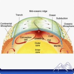
Convection in the mantle. Mantle convection causes seafloor spreading, which is the mechanism that moves the plates.
|
|
|
What is the relationship between convection currents and the features of the ocean floor?
|
Mantle convection cell bring about features seen on the ocean floor including mid-ocean ridges above the upwelling limb and deep sea trenches above the downwelling limb
|
|
|
How do plates move?
|
Like they are on a conveyor belt, riding the upper portions of convection cells.
The upwelling limb of the convection cell erupts new lavas on the mid-ocean ridge axis; older seafloor rides the horizontally-moving portion of the convection cell perpendicular to the ridge axis; oldest seafloor rides the downwelling limb of the convection cell into the mantle |
|
|
Plate tectonics =
|
continental drift + seafloor spreading.
Continental drift driven by the mechanism of seafloor spreading creates plate tectonics. |
|
Explain the features that provide evidence for plate tectonics
|
Upwelling mantle material rises beneath the mid-ocean ridges. As a result, the ridges have high heat flow, which makes them buoyant and so they stand higher than the surrounding ocean floor. The heat also causes the upper mantle to melt, which produces the basalt lavas that erupt at the mid-ocean ridge. This creates new ocean crust.
The mantle material spreads outward in both directions from the mid-ocean ridge, carrying the oceanic crust along with it. The further the mantle moves away from its heat source, the more it cools. Where the cool mantle and the oceanic crust that overlies it plunge back into the mantle, deep sea trenches form. The cool material sinks to the base of the mantle. To complete the convection cell, it travels back to where it began, while being heated by the underlying core. It is then ready to rise again at the upwelling limb of the convection cell. |
|
|
Why are the concepts of density and buoyancy important to plate tectonics theory?
|
Less dense material is more buoyant than and floats above more dense material. More dense material is less buoyant and sinks beneath less dense material
This describes why lithosphere floats on asthenosphere and why oceanic lithosphere subducts into the mantle beneath continental lithosphere or less dense oceanic lithosphere. |
|
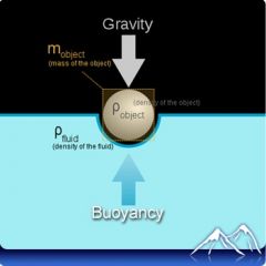
Explain this picture using the concepts of gravity and buoyancy. Is the ball positively, negatively, or neutrally buoyant. Explain
|
Density and buoyancy. When a ball floats on a fluid, its mass and density are both constant. The force of gravity sucks the ball downward but the force of buoyancy pushes it upward. If the two forces are equal, the ball has neutral buoyancy.
|
|
|
What is buoyancy
|
Buoyancy is the upward force that keeps objects afloat. Buoyancy is governed by Archimedes’s principle, which states that Any object, wholly or partly immersed in a fluid, is buoyed up by a force equal to the weight of the fluid displaced by the object
|
|
|
What happens to a ball place in water if the force of gravity is greater than the buoyancy force
|
The ball sinks, it is negatively buoyant
|
|
|
What happens if the buoyancy force increases
|
The ball will rise
|
|
|
The concept that Earth’s lithosphere floats on the denser asthenosphere is known as
|
Isostasy
|
|
|
The crust and uppermost mantle make up the ______
The mantle just below this is the ________ |
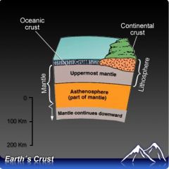
In this scheme, the crust and uppermost mantle are called the lithosphere. The mantle just below the lithosphere is the asthenosphere.
|
|
|
_______ crust is thinner and denser since it is made of denser rock
|
Oceanic
|
|
|
This type of crust is made of an enormous assortment of rock types. It is less dense than the other type of crust and so it is more buoyant. It is also thicker.
|
Continental
|
|
|
Are the oceanic and continental lithosphere more or less dense than the mantle beneath them
Are they more or less buoyant than the mantle |
Both oceanic and continental lithosphere are less dense than the mantle that lies beneath them. They are also more buoyant so they “float” on the mantle.
|
|
|
The Earth is unique in the solar system because it has land masses and oceans. What is the explanation for this unusual arrangement?
|
Continental crust rises above oceanic crust because it is thicker and more buoyant. Earth has water that can fill the basins created by the sunken ocean floor
|
|
A. What happens if a slab of oceanic lithosphere meets a slab of continental lithosphere?
B. What happens when two plates of oceanic lithosphere meet? C. What happens when two plates of continental lithosphere meet? |
A. If a slab of oceanic lithosphere meets a slab of continental lithosphere, the oceanic lithosphere sinks beneath the continental lithosphere.
B. When two plates of oceanic lithosphere meet, the denser one sinks beneath the less dense one. C. When two plates of continental lithosphere meet, they are so buoyant that neither will sink into the mantle. |
|
|
A divergent plate boundary is found
|
Along the floor in the Atlantic Ocean. The divergent plate boundary in the Atlantic Ocean is called the Mid Atlantic Ridge
|
|
|
The feature formed when two oceanic plates collide is called a
|
A trench forms where two ocean plates collide in a subduction zone.
|
|
|
Which of the following occurs at a transform plate boundary?
|
A transform plate boundary is one in which two plates scrape and slide past one another, creating earthquakes.
|
|
|
What will happen if an ocean plate collides with a continental plate?
|
The ocean plate subducts under the continental plate. The ocean plate is denser than the continental plate and therefore subducts, or plunges under, the continental plate.
|
|
|
What are the three types of plate boundaries
|
Convergent boundary, divergent boundary, transform boundary
|
|
|
Plates can move towards each other creating a
|
convergent boundary
|
|
|
Plates can move apart creating a
|
divergent boundary
|
|
|
Plates can slide past each other creating a
|
transform boundary
|
|
|
What will happen to the continents in around 200 million years or so?
|
As the Atlantic grows and the
They will come together in a supercontinent at the other side of the world from Pangaea. Pacific shrinks, the continents are coming together on the other side of the world from where Pangaea formed. |
|
|
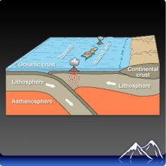
What happens at divergent plate boundaries in the ocean
|
new ocean crust forms as the plates move away from each other. So oceans with divergent plate boundaries are getting bigger. This is why the Atlantic Ocean is growing larger.
|
|
|
What happens at divergent plate boundaries on land
|
they split the continent apart. First the continental crust thins and forms a rift valley. If the plates continue to diverge, a midocean ridge develops and new seafloor is created.
|
|
|
Convergent plate boundary: ocean-ocean. When two oceanic plates converge, one plunges beneath the other at a trench. This region is called a subduction zone. What happens next
|
When the sinking plate gets deep enough into the mantle, it gets hot enough to partially melts. Above this partial melt zone is a chain of volcanoes. The volcanoes are on the plate that overlies the subduction zone. These volcanoes create oceanic islands and together are called an island arc
|
|
|
Convergent plate boundary: ocean-continent. An oceanic plate collides with a continental plate. What is created and how?
|
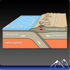
the oceanic plate subducts at the deep sea trench and creates a volcanic arc
|
|
|
Convergent plate boundary: continent-continent. What forms in these types of boundaries
|
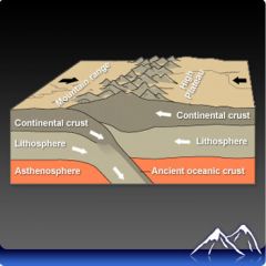
Mountain ranges
|
|
|
Plates move past each other at transform plate boundaries. These plates can both be oceanic or continental.
Where continental plates move past each other, the motion isn’t smooth. A. Plates move along cracks in the crust called ______ B. What is the outcome of this type of plate boundary |
A. Faults
B. Plates move in big jolts known as earthquakes. |
|
|
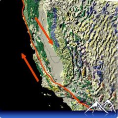
The San Andreas Fault is a
|
Transform plate boundary where the Pacific and North American plates are sliding past each other
|
|
|
Volcanic eruptions are found at
|
convergent plate boundaries because mantle melts as a result of subduction
The subducting plate becomes hot and partially melts, which creates volcanoes above |
|
|
The formation of metallic minerals is
|
Common at convergent and divergent plate boundaries
Metallic minerals commonly form near magma bodies, which are located at divergent and convergent plate boundaries |
|
|
Why are natural resources such as metallic minerals found at subduction zones
|
Metallic minerals form in and near magma chambers and so mineral deposits are often located near volcanoes.
|
|
|
Which types of plate boundaries are volcanoes found. Why
|
Convergent and divergent plate boundaries, NOT transform. This is because there must be melting
|
|
|
The Pacific Ring of Fire is so named because
|
Volcanoes and earthquakes are found in many places along the rim of the Pacific Ocean basin.
The Pacific Rim is lined with convergent plate boundaries where there are both earthquakes and volcanoes. But where there is a transform plate boundary, such as at the San Andreas Fault, there are only earthquakes, no volcanoes. |
|
|
The San Andreas Fault is
|
a right-lateral strike slip fault
Motion on the San Andreas Fault is horizontal and a person standing with one foot on the pacific Plate and one on the North American plate would have the crust beneath the right foot moving toward them. |
|
|
The earthquake waves that travel fastest are
|
P-waves arrive at a seismograph first because they travel fastest
|
|
|
The scale that best reflects the size of an earthquake is the
|
The moment magnitude scale measures the total energy released by an earthquake
|
|
|
Geologists use information about the arrival times of P and S waves to determine the
|
location of the epicenter
Scientists examine the arrival times of the P and S waves from at least three different seismic stations to determine the distance of each to the epicenter of the earthquake by a process called triangulation |
|
|
Earthquakes take place along faults. A fault is a plane that separates blocks of rock that are moving in opposite directions. What are the two types of faults
|
dip-slip and strike slip
|
|
|
The amount of motion that the rocks along the fault undergo and the orientation of the fault is the _____ ________ of an earthquake
|
focal mechanism
|
|
|
Earthquake energy travels as waves. The energy released during by an earthquake travels as ______ waves.
|
Seismic
|
|
|
What are the two types of seismic waves
|
Body and surface
|
|
|
P waves and S waves are the two types of _____ waves
|
Body
|
|
|
Which substances can P waves travel through
|
Any substance, solids, liquids, and gases.
|
|
|
P waves are compressional waves. What does this mean
|
The medium they travel through is compressed and dilated in the direction the wave is moving. When a P wave passes through a structure, such as a building, the structure compresses and expands, causing it to weaken and even collapse.
|
|
|
S waves are the second waves to arrive at a seismic station. They travel in a _____ to ______ motion and shake buildings _____ to _____.
|
side-to-side
|
|
|
S waves can only travel through ______
|
solids
|
|
|
______ waves are much slower than S waves and P waves. They roll along the surface like the ripples on a pond and also move side-to-side.
|
surface waves
|
|
|
Seismologists determine the epicenter of an earthquake using seismographs.
How do you locate the epicenter |
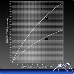
subtract the arrival time of the first P wave from the arrival time of the first S wave. Find that time on the time-travel graph.
Use that number to find the distance that seismic station is from the epicenter. All the points that are that distance from the seismic station, can be plotted as a circle around the seismic station. |
|
|
How many seismic stations are needed to find the earthquake epicenter
|
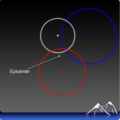
At least three seismic stations are needed to find the earthquake epicenter.
If there is information from only one station, the epicenter of the earthquake could at any point on that circle. If there is information from two stations, the circles intersect at two points, so there are two possible epicenters. With three stations, the circles intercept at only one point, which must be the epicenter |
|
|
The Modified Mercalli intensity scale determines intensity of an earthquake by
|
asking people what they saw and felt during and after the event.
People to choose a number from 1-12 to rate earthquake intensity. |
|
|
What are the four main factors of earthquake damage
|
The strength and amplitude of the seismic waves, distance of a location to the epicenter, duration of shaking, geology of an area.
|
|
|
Which earthquake is likely to do the most damage?
|
one with a large moment magnitude but a fairly small Richter magnitude
The moment magnitude scale measures the total energy released by the earthquake and so is a better measure of the magnitude of an earthquake |
|
|
When magma or lava cools and hardens into rock, it forms
|
An igneous rock is formed from cooled and hardened magma or lava
|
|
|
In order for a rock to be changed into a metamorphic rock, what must be done to the original rock?
|
Heat and pressure must be added
|
|
|
Where do most sedimentary rocks form?
|
in the water. Sedimentary rocks form as particles of sediment settle out of solution in a body of water and are gradually compacted and/or cemented together
|
|
|
How can an igneous rock change into a sedimentary rock?
|
The rock must be weathered and then the sediment is compacted together
|
|
|
The igneous rock, granite, experiences great heat and pressures. The rock eventually melts and forms a new rock. What type of rock would the new rock be?
|
As soon as a rock melts, it becomes magma. Cooling magma inside Earth’s crust forms intrusive igneous rock
|
|
|
Can igneous rocks form on Earth's surface
|
Yes, when magma reaches Earth’s surface and spills on to the ground, it is known as lava. Cooling lava will form igneous rocks with much smaller crystals. Volcanic eruptions typically involve lava as well. The igneous rocks formed as the result of a volcanic eruption are typically glassy or full of holes
|
|
|
What do sedimentary rocks form from and what is the process
|
Sediment is compacted into sedimentary rock. Over time, as sediment is deposited in horizontal layers, the lower most layer will become compacted and turn into sedimentary rock.
|
|
|
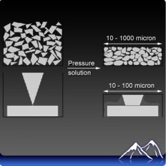
Sediment is often cemented together as well to form a sedimentary rock. ________in the sediment begin to dissolve.
|
Minerals
|
|
|
Dissolved minerals form a __________ between the sediments.
|
glue like bond
As the sediment hardens, the glue and the compaction help form the rock |
|
|
What are the three types of sedimentary rocks
|
clastic, organic, and chemical
|
|
|
What type of sedimentary rocks are formed when broken pieces of other rocks are compacted and cemented.
|
Clastic
|
|
|
How do organic sedimentary rocks form
|
from the remains of plants and animals
Coal and limestone are common organic sedimentary rocks |
|
|
How do chemical sedimentary rocks form
|
when dissolved minerals come out of solution. For example, chemical sedimentary rocks may form when a shallow sea or saltwater lake evaporates. Deposits of rock salt and rock gypsum are examples of chemical sedimentary rocks.
|
|
|
When heat and pressure change an existing rock into a metamorphic rock, what else changes
|
the mineral composition, appearance, texture, and crystal structure change as well
|
|
|
Metamorphic rocks can be classified as
|
foliated or nonfoliated
|
|
|
What is the difference between foliated and nonfoliated rocks
|
Foliated rocks have grains arranged into bands or parallel layers.
Nonfoliated metamorphic rocks do not show banding. The mineral grains within these rocks are arranged randomly. |
|
|
Can a metamorphic rock change into a different metamorphic rock? If so when?
|
Yes, if subjected to more heat and pressure
|
|
|
The relative age of a rock is its age
|
compared to the ages of other rocks
|
|
|
Two rock layers are deposited horizontally. The one on the bottom has been cross cut by a fault. The one on the top has not been affected by the fault. Which feature is the youngest
|
the upper rock layer that is not cross cut by the fault
The bottom layer was deposited. It was cross cut by the fault, and then after that the upper layer was deposited. |
|
|
What do geologists use to determine the absolute age of a rock formation
|
radiometric dating
|
|
|
A radioactive element has gone through three half-lives. How much of the original element is left over?
|
12.5 %
If one half of the atoms of an element decay or disappear in a half-life, then after three half-lives have passed, there must be 12.5% of the original element left |
|
|
What is the absolute age of a rock
|
The absolute age of a rock is a calculation of the number of years that have passed since the rock formed.
|
|
|
How do index fossils help determine relative ages of rocks
|
Index fossils are from an organism that did not exist for long.
Careful examination of the index fossils in rocks helps geologists determine the relative ages of the rocks that they occur in |
|
|
How do layers of sedimentary rock provide a relative history of an area
|
The law of superposition states that in layers of horizontal sedimentary rock, the oldest layer is on the bottom. Each horizontal layer above that is younger than the layer below it. This law makes it possible to determine the relative ages of undisturbed layers of sedimentary rock.
|
|
|
What is an igneous intrusion
|
An igneous intrusion is magma that cools and hardens as it is pushed up into rocks from deep within the mantle.
|
|
|
How does an igneous intrusion help determine relative age
|
An igneous intrusion is always younger than the rocks that surround it. Those rocks had to have been in place already in order for the magma to move into it.
|
|
|
How do faults help determine relative age
|
A fault is always younger than the rocks it cuts across. To determine the relative age of a fault, one must know something about the relative age of the youngest rock the fault cross cuts
|
|
|
Some elements are unstable. Over time, these elements break down. When an element breaks down, particles and energy are released. This is the process of
|
radioactive decay
|
|
|
Unstable elements are also called
|
radioactive elements
|
|
|
When an unstable element decays
|
The atoms of that element change into a different element
|
|
|
The rate of decay for a particular element is
|
The half life of the element
|
|
|
Explain what half-life is
|
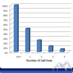
The half-live of a radioactive element is the amount of time it takes for half of a radioactive element to decay. As is seen here, after 1 half-life has passed, 50% of the original atoms remain. After three half-lives have passed, 12.5% of the original radioactive element remains.
|
|
|
What is released by a radioactive element when it decays?
|
particles and energy
The decay of a radioactive element will release particles and energy until the element finally changes into a stable element |
|
|
It is possible to determine the age of a rock using
|
radioactive dating
|
|
|
Supposed a rock contains 3 grams of potassium-40. From the chart on the previous screen, you know that K-40 has a half life of 1.3 billion years. It is possible to determine how much K-40 is left after 4 half-lives have passed.
|
After one half-life passed, there are 1.5 grams of K-40 left.
0.75 grams are left when 2 half-lives have passed. After the passage of three half-lives, 0.375 grams of K-40 remain. And after four half-lives have elapsed, a total of 0.1875 grams remain. If each half-life that passes in the decay of K-40 is equal to 1.3 billion years, then 5.2 billion years have passed when the decay has gone through four different times. |
|
|
______ _______ is necessary for absolute dating
|
radioactive dating
|
|
|
The concept of catastrophism stated that
|
the biological and physical history of Earth was the result of sudden rapid events
Catastrophism states that sudden widespread catastrophes created what we see on Earth’s surface now |
|
|
The concept of catastrophism was abandoned because
|
there was no physical evidence to support it
There was no evidence in the rock record to support the idea that six major catastrophic events shaped Earth’s surface |
|
|
Early scientists reasoned that because of uniformitarianism, conditions on Earth
|
remained essentially constant and unchanging over time
|
|
|
The principle of uniformitarianism can be summed up as follows
|
“The present is the key to the past”
The principle of uniformitarianism proposes that the processes we see occurring on Earth’s surface today are the same processes that were in operation long ago. |
|
|
What is the concept of catastrophes
|
6 major catastrophes have occurred throughout Earth’s history (major flood, volcanic eruption, or earthquake)
They caused life in the area to die off. After each catastrophe, new organisms either were created or moved from other areas. |
|
|
Which of the following is an example of an unconformity?
|
Tilted beds of sandstone underlying horizontal layers of limestone
The sandstone layers were titled by some tectonic process, erosion occurred, and then the horizontally layers of limestone were deposited |
|
|
What is plutonism and nepuntism
|
He had originally thought that igneous rocks formed through a process called plutonism. Plutonism was the idea that igneous rocks came from cooling magmas. This replaced what was at the time the prevalent idea for the origin of igneous rocks. That was a theory called neptunism which said that igneous rocks dropped out of solution from sea water.
|
|
|
What is an unconformity
|
An unconformity is a gap in time, indicating time of erosion n the rock record. He studied rocks in Scotland and found rocks that were tilted upward overlaid by horizontal layers. This indicated, to him, that the gap in time between the tilting and the horizontal deposition was significant.
|
|
|
Hutton, and also Lyell, saw the history of Earth as being ______ in nature. They noted that continents eroded, these eroded sediments were deposited in oceans, and later the ocean floor was uplifted to create new continents. This was a large cycle.
|
cyclical
|
|
|
Lyell is largely credited with disproving __________ as an explanation for geologic phenomena
|
catastrophism
|
|
|
Hutton also was one of the first to suggest that
|
geological processes take a very long time.
|
|
|
Earth’s topography is always
|
Tectonic forces build up landforms, while erosional processes tear them down. For these reasons, the planet’s topography is constantly changing.
|
|
|
The dominant agent of erosion is
|
water running downhill
Water is the dominant agent of erosion because together it is more abundant and more powerful than wind, ice and ocean waves |
|
|
An important result of deposition is the
|
formation of landforms
When sediments are deposited by wind, water, ice or gravity, landforms are created |
|
|
Erosion is the
|
Erosion is the process that tears down landforms.
|
|
|
What is weathering, what are the two types
|
Weathering processes break down rocks into smaller sediments like pebbles, sand, silt and mud.
Physical weathering does not alter the chemical makeup of a material; it just breaks the material down into smaller pieces. Chemical weathering changes the chemical composition of the material |
|
|
What is erosion
|
Rocks, minerals, soil and other particles that have been made small enough are then removed by erosion. As erosion removes material, it alters the shape of landforms
|
|
|
What are the agents of erosion
|
Running water, ocean waves, wind, and ice are the agents of erosion. Gravity is also an agent of erosion since it causes landslides
|
|
|
What is creep
|
a slow erosional process
An example is soil sliding imperceptible down a hill |
|
|
In steam erosion, the energy of a stream depends on its
|
slope and the volume-flow of water
|
|
|
U-shaped valleys, and steep cliffs with waterfalls where rivers are left hanging are evidence of
|
glacial erosion during the ice age
|
|
|
What is transport
|
After material is picked up by erosion it is transported short or long distances. It can occur at different rates
|
|
|
Name some transport agents
|
waves, wind, water
|
|
|
What is deposition
|
Material that is transported is eventually deposited.
Waves, wind, water and ice all deposit the sediments that they eroded and transported. |
|
|
When does deposition occur
|
when the transporting agent slows and no longer has the energy to carry the material
|
|
|
Name some examples of deposits
|
Wind deposits sand in dunes
Rivers carry sediment to the sea and deposit it in deltas Glaciers dump rocks into piles called moraines |
|
|
To create a glacial moraine
|
Sediment is eroded from an existing rock or landform by a glacier. The glacier transports the sediment and then deposits the material as the glacier melts away
|
|
|
Coastal processes can be viewed as a battle between
|
land-dominated deposition and ocean-dominated erosion
Rivers bring sediment to the shore and ocean waves move the sediment along the shore and offshore. |
|
|
A landslide at the coast may occur because
|
rains saturate a hillside causing soil to fall downslope,
waves undercut a cliff causing the sand to fall down slope, an earthquake triggers material on an unstable slope to slide downhill |
|
|
California is not prone to hurricanes because
|
the water offshore is too cold
|
|
|
Barrier islands are
|
extremely unstable, with sand moving down current and on and off shore
|
|
|
Besides moving sand along a shore or offshore, waves may undercut a bank, causing a landslide. This is called
|
beach erosion
|
|
|
How and where do hurricanes take place
|
These storms form in the tropics where the ocean surface is warm.
The prevailing winds take the storms toward the west and then they reverse direction and move eastward |
|
|
The California coast has rocky headlands and sandy cliffs with miles of sandy beaches in spots. There are no barrier islands or similar sandy features. Which of the following is true of the California coast?
|
Ocean-dominated processes win out over land-dominated processes
The lack of sand features like barrier islands suggests that erosion from ocean waves dominates over deposition by rivers |
|
|
In San Francisco in the 1906 earthquake, the greatest amount of damage was done by
|
Gas lines broke and fires started. Since water mains had also broken, there was no way to fight the fires.
|
|
|
Natural disasters around the Pacific Rim are
|
common due to the presence of plate boundaries
Convergent plate boundaries around the Pacific have resulted in most of the volcanoes and earthquakes being located in this region. Transform plate boundaries generate earthquakes |
|
|
The natural disasters that are most easily predicted in time and location are
|
Floodwaters travel down a river. If the speed of the water and flow is understood, the approximate time of arrival can be calculated. The other three disasters can only be generally predicted.
|
|
|
The best way and most practical way to avoid damage from natural disasters is
|
studying hazard maps to determine where the worst and best locations for building are.
|
|
|
What is the natural environment response to an earthquake
|
the natural environment recovers quickly from earthquake damage. Vegetation grows back and animals rarely are harmed.
|
|
|
How do earthquakes effect human environments
|
Buildings collapse, gas pipes rupture, giving ready fuel to start and feed a fire.
Water lines rupture = no way for the fires to be put out. Buildings may tilt Roads, pipes and other structures may break. Silt mixed with water creates something like quicksand. May trigger a landslide, causing the soil, houses and other structures to slide downslope. |
|
|
What are human responses to an earthquake
|
About all that is possible is for a person to go under a strong table or beneath a door frame when the ground starts to shake.
To prepare for the aftermath of a quake, each household should have water, food, flashlights Cities in earthquake prone regions must take precautions far in advance. |
|
|
What is a tsunami
|
enormous waves that are triggered by undersea earthquakes or volcanic eruptions
|
|
|
What are the effects of volcanic eruptions on natural and human-made habitats
|
Explosive eruptions cause the most damage by spewing ash and rock over enormous areas
|
|
|
What is the environmental response to volcanic eruptions
|
may reduce air quality. Ash injected into the stratosphere can block the Sun’s rays, cooling temperatures and reducing the ability of plants to photosynthesize
Volcanic gases may mix with water droplets to form acid rain, which can damage plant-life. Carbon dioxide is a greenhouse gas and may raise atmospheric temperatures |
|
|
What are the effects of landslides on natural and human-made habitats
|
Landslides damage to the houses or habitats that they drag downhill and whatever they bury when they reach the ground below.
|
|
|
What are the effects of floods on natural and human-made habitats
|
Floods can bury or wash away habitats or human development
|
|
|
What are human responses to floods
|
Planting vegetation to retain water and stabilize hillsides slows water and soil from moving downhill. Digging channels to take on extra water or for diverting water. Building levees and dams also help
|
|
|
What is the environmental response to flooding
|
Flooding over farmland is beneficial since river water brings nutrients onto the soil that are useful for growing plants – a natural fertilizer
|
|
|
Water is given off from leaves on trees by the process of
|
transpiration
Water is released from the leaves of plants as water vapor into the air by the process of transpiration |
|
|
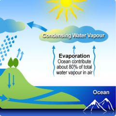
Which of the following drives the water cycle?
|
The Sun is the source of energy for the water cycle.
|
|
|
Most evaporation on Earth takes place
|
over the oceans
|
|
|
Rain that falls on a paved parking lot will most likely
|
flow along the surface as runoff
|
|
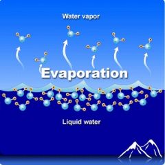
Explain the process of evaporation using this picture
|
When water evaporates, the molecules on the surface absorb energy from the Sun. These molecules, with their added energy, change into water vapor and escape into the atmosphere.
|
|
|
How do plants play a role in the water cycle
|
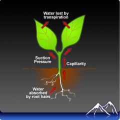
Plants take water from the soil into their roots. The water passes through the plant and eventually is given off from the surface of the leaves. This process is called transpiration
|
|
|
Explain the process of condensation
|
Water vapor in the atmosphere will rise upward on warm air currents. The air will cool as it rises. Cooler air can hold less water than warmer air. Therefore the water vapor will cool and return to the liquid state
|
|
|
________ in the atmosphere leads to the formation of clouds
|
Condensation
|
|
|
Clouds become heavy with moisture and the water then falls to the surface in the form of snow, sleet, rain, or hail. This is called
|
Precipitation
|
|
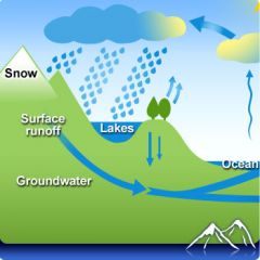
Precipitation that falls may infiltrate into the soil and become part of
|
groundwater or the water that fills the cracks and pores in the rock layers and soil underground
|
|
|
The process by which water vapor is changed to liquid water is called
|
condensation
Water condenses when the air holding water vapor cools. The cooler air cannot hold as much water and some of that water falls out of the atmosphere as liquid water. This liquid water may form fog or the clouds we see in the sky |
|
|
permeable or porus rock layers
|
are able to hold water
|
|
|
A rock is impermeable if
|
water can NOT pass through it
|
|
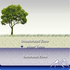
What happens as water infiltrates the ground
|
The water will pass through the permeable layer. It will not be able to pass through an impermeable layer and the water will start to fill up the permeable layer.
|
|
|
When will the water table drop and rise
|
During times of drought, the water table will drop.
If there is a lot of precipitation, the water table will rise. |
|
|
Does groundwater or surface water have a better chance of being purified
|
Water that infiltrates into the groundwater has a better chance of being purified. This water moves slowly through the pores of the soil or rock. This slow movement through very small pore spaces allows the contaminants that may be contained in the water to be filtered
|
|
|
Energy on the Earth’s surface comes primarily from
|
solar radiation
Solar radiation supplies nearly all the energy for the Earth’s surface, including for photosynthesis, which is energy source for nearly all life on the planet. |
|
|
The Earth’s axial tilt is
|
the difference between its axis of rotation and a line perpendicular to its orbit
The axial tilt is the amount the Earth tilts towards or away from the Sun. |
|
|
Summer solstice in the Northern Hemisphere
|
is the day the North Pole receives the most solar radiation of any day of the year
On summer solstice, the Earth is tilted toward the Sun so that the Sun is overhead at the furthest north location all year. This means that the North Pole receives its must sunlight on that day of any day during the year |
|
|
Comparing the poles and the equator, sunlight is most intense and of longest duration at the
|
The most intense sunlight is found at or near the equator. The longest period of time a region is beneath sunlight is at the poles during the summer months
|
|
|
day length is different throughout the year because of
|
axial tilt
|
|
|
When is the sun at its highest point each day
|
noon
|
|
|
When is the suns intensity greatest
|
when it is highest in the sky
|
|
|
Why is the summer solstice the longest day of the year in the Northern Hemisphere
|
Because it is tilted the most toward the Sun on summer solstice (June 21 or 22). The Sun’s rays reach the farthest north on summer solstice
|
|
|
Why is the winter solstice the shortest day of the year in the Northern Hemisphere
|
On winter solstice (December 21 or 22) in the Northern Hemisphere, the Earth is tilted the opposite way from summer solstice. That is when the Northern Hemisphere is tilted farthest away from the Sun.
|
|
|
What causes the seasons?
|
The 23.5° angle of tilt in the planet’s axis of rotation
The tilt of the axis of rotation means that the Northern and Southern Hemispheres receive very different amounts of solar radiation during the two halves of the year. This difference causes the seasons |
|
|
At the _______ neither the northern or southern hemisphere receives more solar radiation than the other hemisphere.
|
equinox
|
|
|
Seasons are opposite in the northern and southern hemispheres. When the _______ Hemisphere receives more solar radiation, it is summer in that hemisphere. That is the time the Southern Hemisphere receives its least ______ ________
|
Northern
solar radiation |
|
|
The amount of incoming solar radiation is
|
greater near the equator than at the poles over the course of a year
The equator receives more solar radiation because the sun is more directly overhead there throughout the year, even though days may be longer at higher latitudes |
|
|
___ rises at a low pressure center and sinks at a high pressure center
|
Air
|
|
|
Over the course of a year
|
the amount of energy entering and leaving the Earth system is nearly constant
The amount of incoming solar energy is nearly equal to the amount of energy that is radiated back into space |
|
|
The amount of solar energy that a region receives determines
|
its average air temperature. For this reason, the equatorial regions are warmer than the polar regions.
|
|
|
What is the most important factor that determines a region's climate?
|
its latitude, which is directly related to the amount of solar energy it receives.
|
|
|
What drives atmospheric circulation
|
the difference in the amount of solar energy recieved at the equator versus at the poles
|
|
|
The result of the uneven heating of the Earth is
|
atmospheric circulation
Convection drives atmospheric circulation since warm air from the equator moves toward the poles and cool air from the poles moves toward the equator |
|
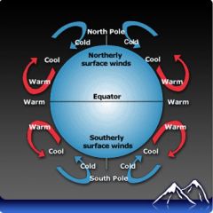
Convection cells move warm air from the equator towards the poles and cold air from the poles towards the equator. What is the result
|
The result is that average temperatures found around the globe are more moderate than they would otherwise be
|
|
|
Coriolis is
|
the effect of the Earth rotating beneath a free-flowing object
Although winds appear to move in a curved direction, they are moving straight and the ground is moving under them |
|
|
For a town in the center of the United States, the location of the polar jet stream determines if the town will
|
If the town is beneath the jet stream, the weather may be extremely stormy. If the jet stream is moving north and south over the town, the weather will be variable. If the jet stream is north of the town, the town’s temperature will be relatively warm. If it is south of the town, the temperature will be relatively cold
|
|
|
The world’s great deserts are at the
|
The horse latitudes are at 30oN and oS where high pressure zones cause more evaporation than precipitation. Air is also warm because much of it came (indirectly) from the equator. These are called the horse latitudes because sailing ships were becalmed in the descending air and horses would die or run out of feed, causing sailors to throw them overboard.
|
|
|
Land breezes are likely to form in winter because
|
In winter, the ocean is warmer than the land and forms a high pressure zone. The air rises and draws air from the land out to sea, creating a land breeze
|
|
|
Winds along the ground are made by the bottom limb of a
|
convection cell
|
|
|
A major factor in determining climate is the
|
global winds belts
|
|
|
Jet streams are rivers of air suspended in the atmosphere. They are found wherever there are large differences in temperature between two masses of air. In the Northern Hemisphere, what are the differences in between locations north or south of the jet stream
|
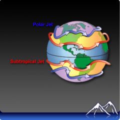
A location north of the jet stream is beneath polar air and will be cooler than one south of the jet stream where the air has come from warmer regions
|
|
|
Why do land areas near an ocean have more moderate temperatures than those that are further away.
|
Oceans moderate temperature because large bodies of water can absorb or release a lot of heat without only slight changes in temperature
|
|
Wind is created by air moving from high pressure to low pressure zones. How are land and sea breezes created
|
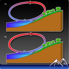
Land and sea breezes. A convection cell forms between warmer land and cooler sea in summer, creating a sea breeze. Convection goes the opposite direction in winter, when the land is cooler than the ocean and a land breeze forms.
|
|
|
Coastal California is much cooler in summer than the Central Valley because
|
Coastal California has much different weather from areas at the same latitude further inland because the Coast Range creates a separate climate zone
|
|
|
Your feet feel hot while walking barefoot on pavement because of
|
The heat is transferred directly from the pavement to your feet in the process of conduction
|
|
|
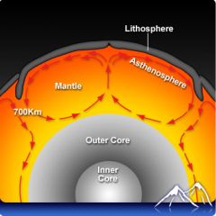
Hot magma rises to the surface of the mantle as cooler magma sinks to the lower part of the mantle due to
|
Convection currents in the mantle move magma
|
|
|
Radiation is the transfer of energy through
|
electromagnetic waves
|
|
|
How does a fireplace heat a room?
|
heat is given off in the form of radiation
The heat given off from a fire is a type of electromagnetic radiation. This energy is what warms the room |
|
|
There is no need for direct contact between two objects for heat to be transferred by
|
radiation
|
|
|
________ is the transfer of heat by direct contact.
|
Conduction
|
|
|
In conduction the heated ______ of a substance are transferred to the _______ of another substance by direct contact.
|
particles
|
|
|
Convection is the transfer of heat by the movement of a
|
liquid
|
|
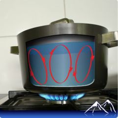
Explain the process of convection taking place in this picture
|
When the water at the bottom of the pot warms, it expands and becomes less dense. Therefore it rises toward the top of the pot. It will float over the denser, cooler water. Gravity will pull this cooler, denser water to the bottom of the pot where it is heated and expands and then rises. This cycle continues until the entire pot of water is heated.
|
|
|
The constant transfer of heat through a liquid creates convection current. Convection currents
|
are put into motion by the combined effects of the heating and cooling of a fluid, the changes in density of the particles of the fluid, and by the force of gravity
|
|
Is this an example of radiation, convection, or conduction heat transfer
|
Convection. Continual convection currents are the cause of much movement on Earth’s crust. This movement includes the movment of the tectonic plates, which in turn causes earthquakes and volcanic eruptions.
|
|
|
Where do convection currents occur
|
In the mantle and in earth's atmosphere
|
|
|
Differences of temperature between the North and South Poles and the equator create giant convection currents in the atmosphere. What is the source of energy for these convection currents?
|
The sun. Warm air rises at the equator and cooler air sinks near the poles. These differences create global winds
|
|
|
What is the driving force behind the movement of tectonic plates on Earth?
|
Convection currents in the mantle are responsible for the movement of tectonic plates on Earth’s surface.
|
|
|
What type of weather is typically associated with stationary fronts?
|
long periods of precipitation
A stationary front is a boundary between a warm air mass and a cold air mass when there is no movement. This produces long periods of precipitation |
|
|
A filled in circle on a weather map represents what percent cloud cover
|
100%
|
|
|
Which of the following joins places of the same temperature on a weather map?
|
An isotherm joins places of equal temperature
|
|
|
If you saw this symbol (two circles with a triangle in between) on a weather map, what would you assume was occurring in the atmosphere?
|
This is the symbol for an occluded front. In an occluded front, a warm air mass is cut off from the ground as it rides up over a cold air mass and is trapped by an overlying cold air mass.
|
|
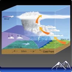
Predict weather outcomes for a cold front.
What is the symbol for a cold front |
1.Clouds form
2.Can produce heavy rain or snow 3.Move quickly (cause abrupt weather changes) The three blue triangles in the symbol of a cold front point in the direction of the movement of the front. |
|
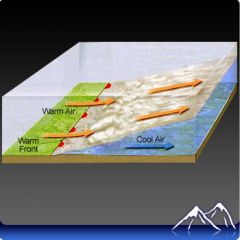
Why do warm air fronts rise up over cold air masses
What weather conditions are likely while the warm front is in the area Do warm fronts move quickly or slowly What will the weather be like after the warm front passes What symbol represents a warm front on a weather map |
Because the warm air is less dense
Light rain or snow if the air is moist, clouds will prevail for several days Warm fronts move slowly The weather will typically be warm and humid 3 red half circles represent a warm front |
|
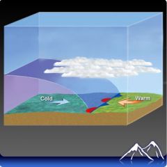
When do stationary fronts form
Predict the weather pattern likely during this type of front Does this type of front move quickly, slowly, or stall What symbol is used to represent stationary fronts on weather maps |
They form when cold air masses and warm air masses meet
Clouds, fog, rain, or snow are all likely to form in a stationary front. Stationary fronts often become stalled over an area. This would bring days of steady rain or snow and cloudy conditions. The symbol for stationary fronts shows a cold and warm front meeting (one upright blue triangle, one downward facing red half circle, one upright blue triangle, one downward facing blue triangle) |
|
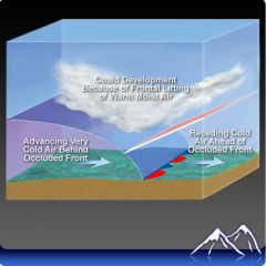
What happens in an occluded front
Predict weather patterns for this type of front What symbol represents occluded fronts on the weather map |
A warm air mass gets caught between two cold air masses
Denser, cooler air moves under a warm air mass, pushing it upward. This denser, cooler air may meet and mix. This will create cloudy weather with the chance of snow or rain. One upward red half circle, one upward blue triange, one upward red half circle, one upward blue triangle |
|
|
the center of a low pressure area is called a
|
cyclone
|
|
|
Low pressure areas are associated with
|
clouds, precipitation, and windy conditions
|
|
|
Areas of high pressure are also called
|
anticlones
|
|
|
Areas of high pressure are associated with
|
dry, clear weather
|
|
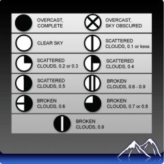
This chart is used to represent
|
cloud cover on a weather map
|
|
|
________ are lines that connect places on a weather map of the same pressure. Air pressure readings are usually expressed as either inches of mercury or in millibars.
|
isobars
|
|
|
Low pressure settles into an area. A warm front moves in. What type of weather can this area expect for the next few days?
|
quick thunderstorms and then cooling temperatures
A low pressure system indicates that it will be cloudy. A warm front usually brings extended periods of rain |