![]()
![]()
![]()
Use LEFT and RIGHT arrow keys to navigate between flashcards;
Use UP and DOWN arrow keys to flip the card;
H to show hint;
A reads text to speech;
13 Cards in this Set
- Front
- Back
- 3rd side (hint)
|
metes and bounds |
best for use in NC, earliest form of legal description. distance=metes direction = bounds used to establish boundaries |
13 original colonies |
|
|
1 acre of land = |
43,560 sq ft. |
|
|
|
government rectangular survey system |
divides land into rectangles, is measured from the intersection of principle meridians and baselines. is referenced by degrees of longitude and latitude ; uses township lines |
|
|
|
call |
each call gives the distance (metes) and direction (bounds) |
|
|
|
monuments |
fixed objects used to establish real estate boundaries stones, large streeams |
|
|
|
POB |
point of beginnning |
|
|
|
rectangular survey |
not used in nc divides land into rectangles |
used out west |
|
|
principle meridians |
run North and South |
|
|
|
Base lines |
run east and west |
|
|
|
townships |
6 sq mile and contain 36 square miles or 23040 acres 1 sq mile=640 acres |
|
|
|
plat = |
previous survey |
|
|
|
Math shortcut |
To calculate acres in a survey system description multiply all the denominators and ÷ by 640 |
|
|
|
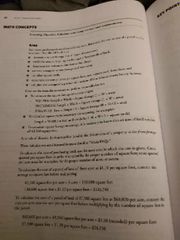
Area |
|
|