![]()
![]()
![]()
Use LEFT and RIGHT arrow keys to navigate between flashcards;
Use UP and DOWN arrow keys to flip the card;
H to show hint;
A reads text to speech;
108 Cards in this Set
- Front
- Back
|
Coasting |
A function that displays the predicted position of a target for a flight plan correlated radar track in the event of a missed or ambiguous radar return. |
|
|
Correlated |
A radar track has been matched to flight plan data on the basis of an aircraft's discrete SSR code or a manual input. |
|
|
Coupling |
A feature which allows transmissions to be simultaneously broadcast on multiple frequencies. |
|
|
CPL |
A live flight plan, with information already in the system in an active state within CAATS. |
|
|
FPL |
This deals with proposed information in CAATS. There is a flight plan but it is not in an active state. |
|
|
Hand-Off |
The process of transferring radar identification of an aircraft target and radio communications for that aircraft, to another sector or unit. |
|
|
Mode-C |
The aircraft's Pressure Altitude. |
|
|
MTCD |
Medium Term Conflict Detection This system looks at the Cleared Flight Level, Mode-C level, Speed and Route and predicts if there will be less than the preset Seperation (5nm) |
|
|
NOTAM |
A notice distributed by means of telecommunication containing information concerning the establishment, condition or change in any aeronautical facility, service, procedure or hazard, the timely knowledge of which is essential to personnel concerned with flight operations. |
|
|
P-E-M |
Plan, Execute and Monitor |
|
|
SIGMET |
Information message issued by a meteorological watch office (MWO) to advise pilots of the occurrence or expected occurrence of specified weather phenomena, which may affect the safety of aircraft operations, and the development of those phenomena in time and space. |
|
|
Splat |
A CAATS symbol for an uncorrelated radar target. |
|
|
SSR |
Secondary Surveillance Radar -Range is normally more than 200nm and uses transponder returns |
|
|
GNSS |
Global Navigation Satellite System Code "G" |
|
|
RNPC |
Required Navigation Performance Capability
Code "R" Aircraft certified as meeting RNPC are permitted to operate on published, high level fixed RNAV routes and also to received improved separation minimums. |
|
|
MNPS |
Minimum Navigational Performance Specifications
Code "X" An aircraft's ability to navigate accurately depends on two things: the pilots ability and level of training, and the navigational equipment with which the aircraft is equipped. |
|
|
RVSM |
Reduced Vertical Seperation Minima Code "W" |
|
|
SELCAL |
Selective Calling System |
|
|
OTS |
Organized Track System |
|
|
TMI |
Track Message Identifier |
|
|
Transfer of Control - TOC of an IFR aircraft to an adjacent sector or unit as follows: |
-So that control transfer occurs at the time of crossing control area boundary as estimated by the sector or unit relinquishing control -At a specified time -When the aircraft is at specified altitude, fix, or location. |
|
|
Uncorrelated |
Targets that are displayed to ensure that you will have a target if decorrelation occurs or to display aircraft on which no flight plan has been entered in Radar Data Processing System (RDPS) |
|
|
TAS |
True Airspeed Equivalent airspeed corrected for air density error |
|
|
Mach |
A reference of how fast something is moving compared to the speed of sound |
|
|
CAATS |
Canadian Automated Air Traffic System The system that automates Air Traffic Control (ATC) functions at area control centres (ACC) and towers |
|
|
CPDLC |
Controller Pilot Data Link Communication Electronic communication system between pilot and controller through which clearances can be sent and readbacks received. |
|
|
GAATS |
Gander Automated Air Traffic System The system used to control aircraft over the North Atlantic. |
|
|
NARDS |
Nan Canada Auxiliary Radar Display System An operationally certified radar display system that operates as a primary display in control towers and selected flight service stations and as an auxiliary display in IFR units. |
|
|
VSCS |
Voice Switching and Control System The main communications panel to utilize frequencies, hotlines and landlines on one digital touch screen. |
|
|
Agreements |
An agreement is a document that contains details between two international agencies. |
|
|
Arrangements |
An arrangement is a document that contains details between two units within NAV Canada. |
|
|
The hours of validity of the two Organized Track Systems (OTS) are normally: |
(i) day-time OTS - 1130 - 1900 UTC at 30°W (westbound)
(ii) night-time OTS - 0100 - 0800 UTC at 30°W (eastbound) |
|
|
One of the main responsibilities of Gander High Level for eastbound aircraft is to ensure that they are: |
-on the route -at the speed, and -at the altitude contained in their oceanic clearance, -as well as verifying that they are separated from other oceanic aircraft |
|
|
Oceanic Separation standard |
10 minute separation standard -is based on two aircraft -at the same flight level -at the same speed (Mach setting) -on the same route |
|
|
BUCS |
Back Up Communications System |
|
|
OIDS |
Operational Information Display System |
|
|
Ground Speed |
Airspeed relative to the ground |
|
|
UPS |
Unit Procedure Specialist Responsible for maintaining and developing unit manuals and procedures, namely the UOM (Unit Operations Manual) and SOM (Sector Operations Manual) |
|
|
ATOS |
Air Traffic Operations Specialist Responsible for all of the data flow in and out of the center; NOTAMS, SIGMETS, Flight Plan Processing, Estimate Processing, AMIS (Aircraft Movement Information Service). They are usually able to fix any flight plan or FDE issues. |
|
|
IFSS |
International Flight Service Station Responsible for communications and service provision to flights in oceanic airspace |
|
|
DSC |
Data Systems Coordinator Responsible for all software and systems that we use |
|
|
TOC |
Technical Operations Coordinator Responsible for all the hardware that we use |
|
|
Class A airspace |
- IFR only
- ATC seperation to all aircraft
- Equipment restrictions
- Includes all of High Level controlled airspace in the Southern Control Area (18,000' ASL - FL600 inclusive)
- All QX High Level (up to FL600) & some QX Low Level |
|
|
Class E airspace |
- IFR and VFR - ATC seperation to only IFR flights - Equipment restrictions - YQX High above FL600 - YQX Low 12,500' ASL and below |
|
|
Class F airspace |
- Special use airspace - "CY" - Canada - "A" - advisory - "R" - restricted followed by a number - "D" - danger (usually CYR airspace over international water) - some list the type of activity |
|
|
RVSM airspace is all airspace within ______ from ___________ as defined in the DAH (TP 1820) and depicted below. |
CDA FL290 to FL410 |
|
|
You may assign an altitude inappropriate to the direction of flight when: |
• The following conditions apply: - The aircraft will be cleared to an appropriate altitude as soon as the conditions permit. |
|
|
Apply RVSM criteria and procedures to only ___________ Do not provide RVSM criteria to _________ If you suspect an aircraft is not approved to operate in RVSM airspace, ______________ |
-RVSM aircraft operating within RVSM airspace. - a formation of aircraft. - ask the pilot to confirm RVSM approval status. |
|
|
Do not clear a non-RVSM aircraft to enter RVSM airspace unless the aircraft is any of the following: |
- A state aircraft - On an initial delivery flight - An aircraft that was formerly RVSM-certified but has experienced an equipment failure and is being flown to a maintenance facility for repair/re-certification - A mercy or humanitarian flight - A photographic survey aircraft - Conducting a flight check of a NAVAID - Conducting a monitoring/certification or development flight |
|
|
Provided a non-RVSM aircraft will be separated from other aircraft by the applicable vertical, lateral, or longitudinal seperation minimum, you may do either of the following: |
- Clear the aircraft to climb or descend through RVSM airspace
- Level-off the aircraft in RVSM airspace for traffic management |
|
|
The vertical separation minimum of _______ may be applied between RVSM approved aircraft operating in RVSM airspace |
1000 feet |
|
|
Separate aircraft vertically by using one of the following minima: A. Below FL290: _________ B. FL290 - FL410: 1) _________ between RVSM aircraft 2) _________ between a Non-RVSM aircraft and any other aircraft C. Above FL410: ___________ |
A) 1000ft B) 1. 1000ft 2. 2000ft C) 2000ft |
|
|
Determine the vertical separation required between the upper limit of a Class F Restricted airspace and an aircraft flying on a standard pressure setting as follows: - If the upper limit is FL290 or above, the minimum separation is __________ - If the upper limit is below FL290, the minimum separation is _________ |
2000 feet 1000 feet |
|
|
If informed that an RVSM aircraft operating within RVSM airspace is no longer RVSM-certified due to an in-flight equipment failure: |
• When traffic permits, do either of the following: - Establish 2000 feet vertical separation or another form of separation with other aircraft in RVSM airspace - Issue a clearance out of RVSM airspace • Obtain the pilot's intentions • If necessary, pass traffic information • Amend the SSR equipment suffix in the flight plan, as appropriate • If appropriate, advise adjacent units/sectors • Notify the supervisor |
|
|
If an RVSM aircraft advised that it is operating with a single primary altimeter, |
acknowledge the transmission and continue to treat the aircraft as an RVSM aircraft. |
|
|
If an aircraft reports greater than moderate turbulence and/or mountain wave activity that is of sufficient magnitude to significantly affect altitude keeping, refer to the following: Non-surveillance - aircraft is being provided with 1000 feet vertical separation - 5 minutes or less from another aircraft |
- traffic permitting, establish 2000 feet seperation or applicable lateral or longitudinal seperation minimum - pass traffic information - report the turbulence and/or mountain wave activity to the supervisor or shift manager |
|
|
If an aircraft reports greater than moderate turbulence and/or mountain wave activity that is of sufficient magnitude to significantly affect altitude keeping, refer to the following: Surveillance -Two aircraft have 1000 feet vertical separation and their targets appear likely to merge |
Pass traffic information Do either of the following: - Vector one or both aircraft to establish surveillance seperation
- Provide 2000 feet vertical seperation until the pilot reports clear of the greater than moderate turbulence or mountain wave activity |
|
|
Apply ADS-B criteria and procedures to |
ADS-B aircraft operating within ADS-B coverage. |
|
|
If both aircraft are identified, and you are in direct communication using VHF/UHF voice with at least one aircraft, ____________, and apply ATS surveillance separation between the centres of PPSs as indicated as follows ________ |
do not permit PPSs to touch
5 miles |
|
|
Give priority to __________ operating in ADS-B airspace, as permitted by flight safety or higher priority flights. |
ADS-B-eligible aircraft |
|
|
Provide air traffic services to aircraft on a "first come, first serve" basis, and give priority as indicated in the following sections. |
1. A pilot who declares an emergency.
2. An aircraft that appears to be in a state of emergency, but is apparently unable to inform you. 3. A pilot who reports that the aircraft may be compelled to land because of factors affecting the safe operation of the aircraft, other than minimum fuel or a fuel emergency
4. Medical evacuation flights
5. Military or civilian aircraft identified by the radiotelephony call sign RESCUE and the designator RSCU followed by an appropriate flight number
6. Open Skies Treaty flights with designators F and D
7. Military aircraft departing on either operational air defence flights or planned and coordinated air defence exercises, unless an emergency condition prevails or may be caused by the departure |
|
|
ADS-B coverage sites |
Cape Dyer PA SV HO
|
|
|
HF |
High Frequency (HF)
DEFINITION: The frequency band between 3 and 30 MHz. - Used by Gander IFSS for communications in oceanic and northern airspace. - Weather and solar activity can make HF communications difficult. - HF radio can travel beyond the horizon by the radio waves reflecting off the ionosphere and back to earth which enables long distance communication.v |
|
|
VHF |
Very High Frequency (VHF) DEFINITION: The frequency band between 30 and 300 MHz. - Use by high level. - VHF frequencies are not affected by weather. - Range of approximately 200 miles o line of sight o the range can be affected by terrain - Some northern frequencies are high powered VHF frequencies (132.65 & 135.32) and their range is approximately 275 miles. |
|
|
UHF |
Ultra-High Frequency (UHF) DEFINITION: The frequency band between 300 and 3000 MHz. - UHF frequencies are primarily used by the military - Very infrequently there will be a request from a military aircraft for a UHF frequency. - High Level does not have any UHF frequencies. - Paired with LL VHF frequencies. |
|
|
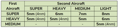
Include the wake category suffixes _______ or _______ as appropriate in the initial contact. After communication is established, you may omit these terms. |
HEAVY SUPER |
|
|
Apply wake turbulence separation as indicated in the table below for any of the following situations: * An aircraft is operating at the same altitude in front of another aircraft * An aircraft is crossing an altitude in front of another aircraft |
|
|
|
Identify the 3 main communication components of VSCS |
-Frequencies -Hotlines -Landlines |
|
|
Coupling is a feature which allows _____________ to be simultaneously broadcast on __________ frequencies. |
transmissions multiple |
|
|
CSiT |
CAATS Situational Display is the main screen controllers use to display air traffic and access tools, ranging from those used to help separate aircraft, to those which allow you to modify a flight plan. |
|
|
QAB |
Quick Action Bar |
|
|
AMIRs |
Aircraft Movement Information Record represents a way to manually input basic data into CAATS so that controllers can make a splat turn into a data tag. |
|
|
What is the difference between CPL and FPL |
CPL - is a live flight plan - information already in the system in an active state within CAATS FPL - deals with proposed information in CAATS - there is a flight plan, but it is not in an active state. - You will see this most often with procedural traffic from New York oceanic. |
|
|
SPR |
Spurious Spurious targets mean that an aircraft is off its expected CAATS profile and CAATS is not able to ascertain with certainty the identity of a target. |
|
|
TxP |
Transmission Pending - the information is delayed in sending to the external unit. - There are instances where the information did actually send but our system did not receive an acknowledgement |
|
|
MOD |
Modification - that although the initial estimate was distributed to the external unit, a subsequent change to the profile did not send. |
|
|
ERR |
Error - the estimate distribution software link has failed, - and no estimate will send on any flights. |
|
|
AWF |
Airspace Warning Feature CAATS will give you a warning 10 minutes prior to if you have an aircraft on a route that will enter restricted airspace. |
|
|
HLD BRIEFING CHECKLIST |
1. Record Briefing 2. Area of Responsibility / FLs 3. SAS / ALTRV"s / SUA 4. Equipment Status 5. Sigmets / Turbulence / Pireps 6. NOTAMS 7. WWA / Delay Climb 8. Separation |
|
|
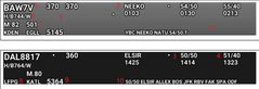
Eastbound FDE Light colored Westbound FDE Darker colored
1. Flight level: - Oceanic level on left, . - Inbound level on right 3. Latitude at 50W & estimate 4. Latitude at 40W & estimate 5. Aircraft identification 6. - Weight Category - Aircraft type - Certification 7. MACH/TAS 11. Remarks (CAATS & GAATS Lines) 12. Non-ADSB indication (if Applicable) |
|
|
For eastbound enroute flights, CAATS automatically passes live estimate data from QM to QX: |
50 minutes prior to the boundary to both High Level and the Planner. FDEs populate for High Level 30 minutes prior to the common boundary. These will populate whether or not the flight has been planned. |
|
|
Prior to terminating radar service on an eastbound NAT aircraft, obtain: |
-for aircraft operating south of UMESI to RAFIN, the estimate and latitude for 50W and the latitude for 40W. - for aircraft operating UMESI and North, and for TALGO traffic, an estimate for the OEP and confirm the latitude for 50W. NOTE: For aircraft on frequency after OEP, obtain the estimate for 50W and confirmation of the 40W coordinate. |
|
|
Prior to terminating radar service on southwest bound aircraft proceeding directly from Gander Domestic Airspace to the New YorkOCA, |
obtain the aircraft estimate for the exit point and confirm the next position after. |
|
|
Inform the pilot of the aircraft's position when any of the following apply: |
-Identification is established by an identifying turn. - Vectoring is terminated, unless you know the pilot has the information. - The pilot requests the information. - You deem it necessary. Describe the position of an aircraft in relation to a fix, airway, course, or radial indicated on the situation display. |
|
|
If you see two aircraft planned to enter oceanic airspace at the same level with ___________ indicate on your FDEs that close to minimum separation exists. |
12 minutes or less |
|
|
When issuing or relaying an IFR clearance or IFR instruction or amendment, |
obtain an accurate readback, unless otherwise specified in an arrangement. |
|
|
QX-QM Arrangement
The transferring unit will not make CAATS or flight plan change(s) without prior coordination for aircraft within: |
-30 nm of the common boundary, or -15 minutes of the common boundary if procedural separation is being applied |
|
|
In Gander the boundary between high level and low level is |
Flight Level 280 - Low level airspace is FL280 and below - High level airspace is above FL280. |
|
|
GAATS+ will send CAATS CPL flight data information: |
30 minutes prior to the oceanic/domestic boundary. |
|
|
Westbound aircraft will be advised to contact High Domestic at 50W except: |
i) 55W for MELDI and north; ii) 10 minutes prior to SAXAN, RIKAL, PELTU, NEEKO; iii) 5 minutes prior to TUDEP; and iv) 10 minutes prior to BOBTU. |
|
|
When a westbound aircraft calls in on initial contact we: |
1. Slash our FDE and 2. Tick the altitude. |
|
|
You may consider an aircraft identified, provided any of the following conditions is met: |
- Identification is transferred by a handoff. - The appropriate change in the PPS is observed after the aircraft is instructed to operate the aircraft's transponder ident feature. -The aircraft is observed on surveillance display at a position that is: - Within one mile of the departure end of the take-off runway -Consistent with the time of takeoff and the route of flight or assigned heading of the aircraft. -The appropriate change in the PPS is observed after the pilot is instructed to change from one code to another. -The aircraft is observed on the situation display and the following apply: -It is over a fix whose position is accurately indicated on the situation display, which is consistent with a position report received directly from the aircraft. -Its track is observed to be consistent with the route of flight or reported heading of the aircraft. -The aircraft is observed on the situation display & the following apply: -Its position, relative to OMNI and DME NAVAIDs indicated on the situation dis play, is consistent with a position report received directly from the pilot in the form of a DME fix. -Its track is observed to be consistent with the route of flight or reported heading of the aircraft. -The PPS disappears or changes to a PSR symbol after the pilot is instructed to change the transponder to "standby" and the PPS reappears or changes to an SSR symbol after the pilot is requested to return the transponder to normal operation. -The aircraft identification element in an ADS-B data tag is recognized and is consistent with the aircraft's expected position. -The aircraft is observed, on the situation display, to have carried out a specified identifying turn of at least 30°, and the following apply: -Except in the case of a lost aircraft, a position report received directly from the aircraft indicates that the aircraft is within ATS surveillance coverage of the area being displayed. -Only 1 aircraft is observed to have carried out the specified turn. -The track is observed to be consistent with the heading or track of the aircraft both before and after completion of the turn. |
|
|
If identification becomes doubtful or is lost, immediately do either of the following: |
Identify or re-identify the aircraft using the same technique more than once or use more than one of the techniques provided in Identification Methods. Terminate ATS surveillance service & apply procedural separation |
|
|
Consider identification to be lost if a correlated PPS ceases to be displayed in its data tag, unless either of the following applies: |
-You are able to maintain identification of an uncorrelated PPS being displayed for the aircraft. -The PPS re-correlates within a sufficiently short period such that, considering the progress of the aircraft, you have no doubt about its identity. |
|
|
You may use the data tag ACID in adjacent airspace where ATS surveillance service is normally provided to identify an aircraft if any of the following apply: |
-The aircraft is observed approaching a fix or an airport, and the time, position, and aircraft track are consistent with a control estimate. See Figure 8 and Figure 9. -You have been informed of the secure arrival or departure sequence. See Figure 10. -You previously identified the aircraft and it has since been handed off to another sector or unit. |
|
|
If an aircraft will enter another sector or unit's airspace, initiate a handoff if any of the following apply: |
-You are applying ATS surveillance separation between the concerned aircraft and another aircraft that was, is, or will be transferred.
-ATS surveillance separation is normally applied in the receiving controller's airspace. -Handoffs are specified as a standard procedure in an agreement, arrangement, or unit directive. |
|
|
Complete a handoff before the aircraft passes any of the following: |
-The sector or FIR boundary -A designated control transfer point -Any handoff point defined in an arrangement or agreement |
|
|
Do an automated handoff, unless either of the following applies: |
-You are handing off an uncorrelated PPS. -A system malfunction or deficiency makes it unfeasible. |
|
|
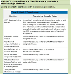
During a handoff, coordinate with the receiving controller... |
|
|
|
Subject to D.2.1, for flights FL290 and above, direct routes which remain within surveillance coverage are approved without prior coordination to the fixes listed below: |
-Any INFs on the QM western boundary including YRI, PQI, TOPPS, and EBONY
-Any QX OEP
-All VOR's, NDB's or enroute intersections located in either the Gander or Moncton AOR.
-The following fixes: CAYLY if the aircraft is filed the CABOT Arrival and AGMIR if the aircraft is filed on the LIRLA arrival. BGR (KBGR Arrivals only, on or south of a line NEEKO - BGR) All arrival fixes (QX FIR)
|
|
|
Amend the clearance of an aircraft that has entered Gander HLD airspace from ocean airspace without coordinating with the oceanic sector provided: |
1. the appropriate oceanic separation minimum is maintained from other traffic still within Oceanic airspace; or 2. the appropriate radar separation minimum is established between traffic in Gander HLD airspace and identified traffic still operating in Oceanic airspace. |
|
|
Westbound NAT aircraft that have been cleared over their flight planned exit point do not require a |
domestic clearance to destination. |
|
|
Direct routings should only be initiated in order to: |
1. solve a separation issue; or 2. provide an operational advantage. |
|
|
Verify ocean estimates at least _________ prior to the ocean/domestic boundary by referencing the CAATS Westbound List |
20 minutes |
|
|
_________ with Gander Ocean before issuing clearances in oceanic airspace |
Coordinate |
|
|
Flight Levels -Filed: _______ -Cleared: _________ -Estimate: ________ -Oceanic: _________ -Current:__________ |
Filed: the level entered in the flight plan before a flight departs Cleared: the level that is assigned by a controller. Also referred to as Inbound Flight Level Estimate: the level that has been passed to downstream sectors or units Oceanic: the level that an aircraft must maintain in oceanic airspace. Also referred to as Planned Flight Level Current: the level that an aircraft is maintaining |
|
|
Is a radar handoff and communications change to QM transfer of control? |
Yes, unless otherwise coordinated |
|
|
What changes happen to the FDE with oceanic clearance? |
A Mach number and Oceanic Level are added to the strip |