![]()
![]()
![]()
Use LEFT and RIGHT arrow keys to navigate between flashcards;
Use UP and DOWN arrow keys to flip the card;
H to show hint;
A reads text to speech;
29 Cards in this Set
- Front
- Back
|
Tectonic plates consist of... |
Either oceanic or continental lithosphere, or a combination of both. |
|
|
Deep oceanic trenches are generally a feature of ______ plate boundaries |
Convergent |
|
|
The lithosphere is generally the thinnest at and near ______ plate boundaries |
Divergent |
|
|
The lithosphere of the earth is generally thickest at or near ________ plate boundaries. |
Convergent |
|
|
At a convergent plate boundary, two opposed plates... |
Move towards one another. |
|
|
The age of oceanic crust ________ with increasing distance from a mid-ocean ridge |
Increase |
|
|
Where is oceanic lithosphere thickest and thinnest? |
Thinnest near ocean ridges and thickens away from oceanic ridges. |
|
|
The mid - Atlantic ridge is... |
A divergent plate boundary |
|
|
Where is sea - floor spreading driven by volcanic activity? |
Along ocean ridges |
|
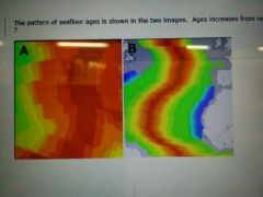
The pattern of sea floor ages is shown below in the two images. Ages increase from red (youngest) through orange to yellow and green (oldest). What are these geological features? |
Spreading centers |
|
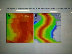
The images are of the age of the ocean floor in two separate localities. Both are to the same scale. Ages are red for younger through orange and yellow to green for oldest. Which of these exhibits the fastest spreading rate? |
A |
|
|
At a subduction zone, what are overriding plates composed of? |
May be composed of either oceanic or continental lithosphere. |
|
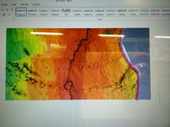
This image shows seafloor age patterns from orange (youngest) through yellow to green (oldest). The pink line is a plate boundary. What type of plate boundary? |
Convergent plate boundary |
|
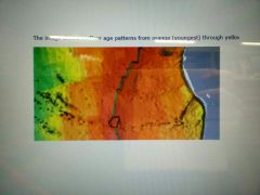
The image shows seafloor age patterns from orange (youngest) through yellow to green (oldest). The green line is a plate boundary. What type of plate boundary? |
Divergent plate boundary |
|
The image shows seafloor age patterns from orange (youngest) through yellow to green (oldest). The blue lines represent plate boundaries. What type of plate boundaries? |
Transform |
|
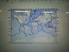
This map shows all the plates of the earth and therefore the plate margins. The margins shown in red are... |
Convergent |
|
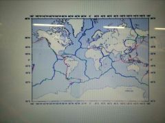
This map shows all the plates of the earth and therefore the plate margins. The margins shown in blue are... |
Divergent |
|
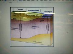
This diagram shows all the typical features of... |
A passive margin |
|
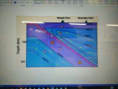
The diagram illustrates the thermal structure of... |
A subduction zone |
|
|
Every plate boundary can be recognised by... |
The present ce of an earthquake belt |
|
|
Hot spots are caused by... |
Hot plumes of mantel material that rise up from the core-mantel bondary |
|
|
What does the theory of plate tectonics incorporate? |
It incorporates and explains both sea-floor spreading and continental drift. |
|
|
Unlike the lithosphere, the Asthenosphere... |
Is able to flow over long periods of time |
|
|
At a transform boundary, two opposed plates... |
Slide past one another |
|
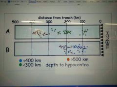
The diagram below illustrates two subduction zones, with the down-going subduction plate moving from right to left. The depth to earthquake hypocentres is shown by the coloured dots. What does this information tell us about the subduction slab? |
The slab dip is greater in B then in A |
|
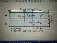
The diagram below illustrates two subduction zones, with the down-going subduction plate moving from right to left. The depth to earthquake hypocentres is shown by the coloured dots. What does this information tell us about the age of the subduction slab? |
The subduction slab is likely much younger in A than in B |
|
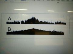
The image below show the topography of two spreading centers. The axes are the same scale on each image. Based on these topographical profiles - which ridge is spreading more slowly? |
Ridge A is spreading more slowly then ridge B |
|
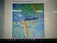
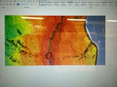
In the diagram below, the black line is... |
A transform and therefore a plate boundary |
|
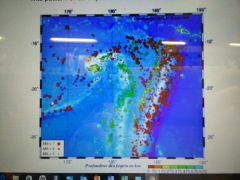
On the image below, the size of the dots represent magnitude of earthquakes (bigger dots, greater magnitude) and the colours the depth of the earthquakes (scale in km at the bottom of the image). This pattern of earthquakes is characteristic of... |
A subduction zone |