![]()
![]()
![]()
Use LEFT and RIGHT arrow keys to navigate between flashcards;
Use UP and DOWN arrow keys to flip the card;
H to show hint;
A reads text to speech;
155 Cards in this Set
- Front
- Back
|
Impact of Moisture on the Landscape |
-Formation of fog, haze, clouds, and precipitation
-Short term impacts of precipitation—floods
-Longer term impacts (i.e., caves) on Earth’s surface |
|
|
Water |
-Two hydrogen and one oxygen molecule (H2O) -Covalent and Hydrogen bonds -Exists as a liquid at most points on Earth’s surface -Capillarity -Good solvent -High specific heat |
|
|
Latent Heat |
-The energy exchanged during a phase change |
|
|
Phase Changes of Water |
-Condensation: gas to liquid -Evaporation: liquid to gas -Freezing: liquid to solid -Melting: solid to liquid -Sublimation: solid to gas and gas to solid |
|
|
Evaporation |
-Molecules escape into the overlying volume as water vapor
-Energy must be available at the water surface
-Water vapor increases in air as surface water evaporates, Windiness reduces evaporation |
|
|
Condensation |
-Water vapor molecules randomly collide with the water surface and bond with adjacent molecules
-Supersaturated air
-Need particle to grow droplet around, a cloud condensation nuclei-Hygroscopic |
|
|
Evapotranspiration |
-The combined process of water vapor entering the air from land sources
-Occurs when ground of location is wet |
|
|
Absolute Humidity |
-Mass of vapor for a given volume of air
-Changes as air volume increases and decreases
-Expressed in g/m^3 |
|
|
Specific Humidity |
-Mass of water vapor for a given mass of air
-Only changes as the quantity of water vapor varies, not affected variation in air volume |
|
|
Vapor Pressure |
-Contribution of water vapor to total atmospheric pressure
-The maximum possible vapor pressure )the water vapor capacity at a given temperature is called saturation vapor pressure |
|
|
Relative Humidity |
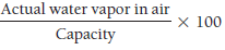
-Describes how close the air is to saturation, the maximum amount of water vapor the air can “hold”, Saturation depends on temperature
-A ratio that compares the actual amount of water vapor in the air to the water vapor capacity of the air |
|
|
Specific Humidity |
-Represents a given mass of water vapor per in a given mass of air
-Does not change as air expands and contracts.
-Saturation specific humidity is the specific humidity of the atmosphere when it is saturated |
|
|
Temperature-Relative Humidity Relationship |
-Inversely related, as temperature increases, relative humidity decreases |
|
|
Processes that Cause Saturation |
1. The addition of water vapor
2. Mixing cold air with warm air
3. Moist air—by cooling the air to dew point |
|
|
Dewpoint Temperature |
-The temperature at which saturation is reached
-Varies with the moisture content of the air
-If a parcel of air has a dew point temp. of 15°C, the we know that the specific humidity of the parcel is 10 g/kg; if the dew point of the parcel of 24°C, then the specific humidity must be 20 g/kg |
|
|
Sensible Temperature |
The temperature as it feels to a person's body |
|
|
Supercooled water |
-Water having a temperature below the melting point of ice but nonetheless existing in a liquid state. |
|
|
Ice Nuclei |
-Required for ice crystal formation, a rare temperature dependent substance similar in shape to ice, active below -4°C -Between -10° and -30°C (14°–22°F), saturation may lead to ice crystals, supercooled drops, or both. -Below -30°C, clouds are composed solely of ice crystals. -At or below -40°C (-40°F) spontaneous nucleation, the direct deposition of ice with no nuclei present, occurs.
|
|
|
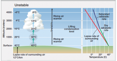
Adiabatic Processes |
-When air rises, its pressure decreased so it expands and cools adiabatically |
|
|
Dry Adiabatic Rate |
-The rate at which atmospheric temperature decreases with increase in altitude |
|
|
Lifting Condensation Level (LCL) |
-The height at which the relative humidity of an air parcel will reach 100% when it is cooled by dry adiabatic lifting |
|
|
Fog |
-A surface cloud when air either cools to the dew point, has moisture added, or when cooler air is mixed with warmer moister air. >Radiation: when the ground looses heat through radiation, usually at night >Advection: When warm, moist air moves horizontally over a cold surface, such as snow covered ground or a cold ocean current >Upslope: created by adiabatic cooling when humid air climbs a topographic slope |
|
|
Cirrus clouds |

-("a lock of hair") Are thin and wispy and composed of ice crystals rather than water droplets |
|
|
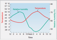
Stratiform clouds |
-("spread out") Appear as grayish sheets that cover most or all of the sky, rarely broken up into individual cloud units |
|
|
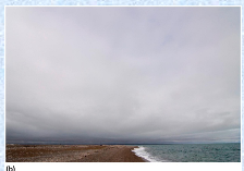
Cumulus clouds |
("mass" or "pile") Are massive and rounded, usually with a flat base and limited horizontal extent but often billowing upward to great heights |
|
|
Cloud Attitudes |
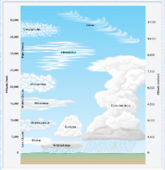
-High clouds (over 6 km) -Middle clouds (from 2 to 6 km) -Low clouds (less than 2 km) |
|
|
Dew |
-Usually originates from terrestrial radiation
-Moisture condensation on surfaces that have been cooled to saturation
-Will appear as water droplets |
|
|
Frost |
-Occurs when air temperature lowers to saturation point, when the saturation point is below 0°C (32°F)
-Will appear as large numbers of small white crystals |
|
|
Buoyancy |
-The tendency of any object to rise or sink in a fluid under the influence of gravity
-Denser objects sink -Less dense objects float -Same density won't float or sink |
|
|
Stable air |
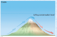
-Parcel is negatively buoyant, will not rise without an external force |
|
|
Unstable air |
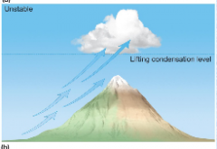
-Parcel is positively buoyant, will rise without an external force |
|
|
Conditional instability |
>Rising air warmer > Rising air same temp >Rising air cooler |
|
|
Precipitation |
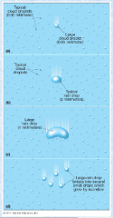
-Originates from clouds -Condensation insufficient to form raindrops -Other processes important -Collision/coalescence—tiny cloud drops collide and merge to form larger drops |
|
|
Ice Crystal Formation |
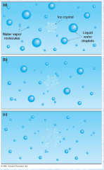
-Bergeron process -Ice crystals and supercooled droplets coexist in cold clouds -Ice crystals attract vapor, supercooled drops -evaporate to replenish the vapor -Ice crystals fall as snow or rain
|
|
|
Types of precipitation |
>Rain: liquid water >Snow: cloud ice crystals >Sleet: snow melted and frozen again before hitting land, ice pellets >Glaze (Freezing Rain): water falls as liquid, freezes to surfaces >Hail: strong updrafts are required |
|
|
Acid Rain |
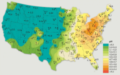
-Rainfall made sufficiently acidic by atmospheric pollution that it causes environmental harm. -Principal acids: Sulfuric and Nitric -Number of hydrogen ions pH
|
|
|
Impact of Storms on the Landscape |
-Storm conditions can result in widespread damage through flooding and wind damage
-Can provide diversity in vegetative cover and increase lake and pond size |
|
|
Properties of an Air Mass |
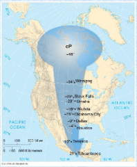
-Large (diameter > 1600 km)
-Uniform horizontal properties
-Recognizable entity; travel as one |
|
|
Origins of an Air Mass |
Remains over a uniform land or sea surface long enough to acquire its uniform characteristics |
|
|
Air Mass Stability |
-Stable: moves up, and back down. Returns to its original position
-Unstable: moves up, over, and down. Does not return to its original position |
|
|
Air Mass Classification |
Two letter classification system (xX) c => continental, dry m => maritime, humid
P => polar source region T => tropical source region A => arctic source region E => equatorial source region |
|
|
Air Mass source regions |
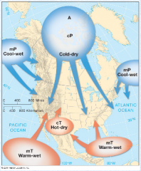
Cool-wet Cold-dry Cool-wet
Warm-wet Hot-dry Warm-wet |
|
|
Fronts |
a zone of discontinuity between unlike air masses where properties of air change rapidly |
|
|
Four Primary Frontal Types |
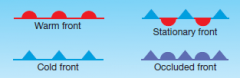
-Cold front: cold air advancing -Warm front: warm air advancing -Stationary front: no advance of air masses -Occluded front: cold air overtakes warm air |
|
|
Cold Front |
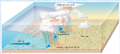
-Protruding “nose” of cold air -Faster than warm fronts -Lift warm air ahead of cold fronts -Identified by blue line with triangles pointing in direction of frontal motion |
|
|
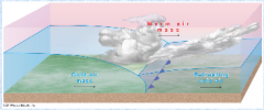
Warm Front |
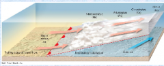
-Gentle slope of warm air rising above cool air -Slow cloud formation and precipitation -Indicated by red line with semicircles pointing in the direction of warm air motion |
|
|
Midlatitude disturbances |
-The midlatitude s are the principal "battleground" of tropospheric phenomena: where polar and tropical air masses meet
-Mid-latitude cyclones and anticyclones |
|
|
Tropical disturbances |
-The low latitudes are characterized by monotony, the same weather day after day, week after week, etc
-Easterly waves and hurricanes |
|
|
Localized severe weather |
-Atmospheric disturbances that occur in many parts of the world
-Thunderstorms and tornadoes |
|
|
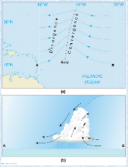
Midlatitude Cyclones |
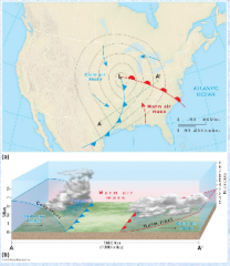
-Exist between 35–70° latitude -Roughly 1600 km in size -Central pressure near 990 to 1000 mb -Converging counterclockwise circulation in Northern Hemisphere -Circulation creates fronts -Westward tilt with increasing elevation in Northern Hemisphere |
|
|
Midlatitude Cyclone Movement |
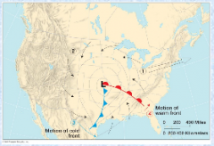
-Steered by jet stream -System has a cyclonic wind circulation -Cold front advances faster than center of the storm |
|
|
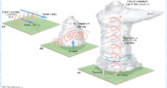
Midlatitude Cyclone Life Cycle |
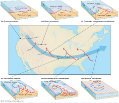
b) Wave develops a) Front dev b) Cylonic circ. est.
d) Occl begins f) Cyclone diss. e) Occluded front dev |
|
|
Occlusions (occluded front) |
-Cold front catches warm front, removing the energy of the storm (which is the warm air) -Occlusions mark the end of the cyclone’s life -Marked as a purple line with alternating triangles and half circles in direction of advancing cold air |
|
|
Midlatitude Cyclones: Occurrence and distribution |
-Typically 6–15 cyclones exist worldwide
-More numerous and better developed in winter than in summer
-Move more equatorward during summer |
|
|
Midlatitude Anticyclones |
-Subsiding, diverging winds at the surface -Flow is clockwise around an anticyclone -Move slightly slower than cyclones
-Relationship to cyclones: >Occur independently, but have a functional relationship >Anticyclone follows a cyclone >Anticyclones typically reside behind cyclone’s cold front |
|
|
Easterly Waves Minor Tropical Disturbances |
-A long but weak migratory, low-pressure system that may occur in almost anywhere between 5° and 30° of latitude -Oriented N–S -Little cyclonic circulation -Convergence behind wave, divergence ahead of wave -Can intensify to tropical cyclones |
|
|
Hurricanes (Tropical cyclone) Major Tropical Disturbances |
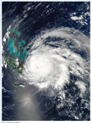
-An intense, low-pressure disturbance that develop in the tropics and occasionally move poleward into the midlatitudes -Tropical depression: winds < 38 mph -Tropical storm: winds 38–74 mph -Hurricane—winds > 74 mph >Typhoons >Baguios >Cyclones |
|
|
Hurricane characteristics |
-Prominent low pressure center, winds spiral inward -Steep pressure gradient and strong winds -Warm moist air enters storm to form rain and release latent heat -Eye wall and eye -Anticyclonic winds aloft, divergence aloft
|
|
|
Hurricane origins |
-Over warm water
-A few degrees N or S of equator
-No significant wind shear
-Hurricane season |
|
|
Hurricane movement |
-Irregular tracks within the flow of the trade winds
-Typically begin moving east–west, some curve poleward |
|
|
Hurricane: Damage and Destruction
|
-High winds, torrential rain, and isolated tornadoes
-Primary destruction, storm surge flooding
-Saffir-Simpson scale |
|
|
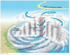
Thunderstorms Localized Severe Weather |
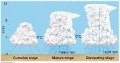
-Violent convective storms -Accompanied by thunder and lightning -Formation stages: >Cumulus stage >Mature stage >Dissipating stage -Atmospheric conditions prone to thunderstorm formation |
|
|
Lightning Localized Severe Weather |
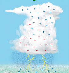
-Electric discharge in thunderstorms -Separation of charges due to ice particles in a cloud -Positive charges on Earth’s surface Lightning types: >Cloud to ground >Cloud to cloud >Within cloud -Thunder |
|
|
Tornadoes Localized Severe Weather |
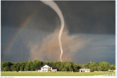
-Deep low pressure vortex, typically less than 400 meters in diameter -Fast winds, sometimes in excess of 300 mph -Originate above ground, water vapor condenses into funnel cloud -Contains vapor and debris |
|
|
Tornado formation |
-Vertical wind shear creates rotation with horizontal axis
-Horizontal rotation tilted into vertical by thunderstorm updraft
-Mesocyclone and tornado development |
|
|
Earth's Water |
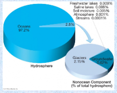
-(99%) is in storage in oceans, lakes, rivers, glacial ice, or rocks beneath the surface
-Remaining fraction involved in a continuous sequence of movement and change
-Movement is the hydrologic cycle |
|
|
Surface to air The Hydrologic Cycle |
-Ocean evaporation
-Vapor remains in air for a short time |
|
|
Air to Surface The Hydrologic Cycle |
-Precipitation—78% falls on oceans and 22% on land
-Precipitation is the same as evaporation over long time scales |
|
|
Movement beneath the surface (runoff) The Hydrologic Cycle |
-Water collects in lakes and rivers and either penetrates ground or runs off if sloped
-Becomes part of underground water supply
-Reemerges as springs or becomes part of rivers and streams |
|
|
The Oceans |
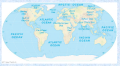
-Four principal parts: >Pacific—largest, occupies 1/3 of total Earth surface area >Atlantic—less than half the size of the Pacific >Indian—slightly smaller than Atlantic >Arctic—small and shallow
Smaller bodies: seas, gulfs, and bays |
|
|
Characteristics of ocean waters |
Chemical composition: >Sodium and chlorine >Salinity Increasing acidity: >Carbon dioxide absorbed by ocean water creates carbonic acid >Affects the ability of microscopic creatures to >build shells and exoskeletons Temperature: >Decreases with increasing latitude >Ranges from near 80 °F to near 28 °F Density: >High temperature means low density >High salinity means high density |
|
|
Tides Movement of Ocean Waters |
Bulges in sea surface in some places that are compensated by sinks in the surface at other places Significant in shallow water areas for horizontal placement of water |
|
|
Causes of Tides |
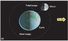
-Gravitational attraction of Moon (lunar tides) and Sun (solar tides) -More gravitational force on the side of Earth facing the Moon -More centripetal force on opposite side to keep --Earth in orbit -Two bulges form on opposite sides of planet -Two tidal cycles in 25 hours -Flood tide and high tide -Ebb tide and low tide |
|
|
Monthly Tidal Cycles Movement of Ocean Waters |
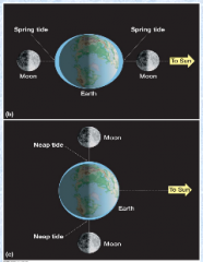
-Tidal range: difference in high and low tides -Spring tides -Neap tides |
|
|
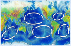
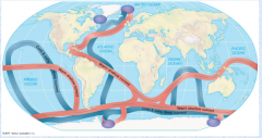
Currents Movement of Ocean Waters |
-Subtropical gyres develop from surface wind patterns -Deep ocean circulations: >Result from differences in salinity and temperature in deep ocean water >Thermohaline circulation >Water in northern latitudes is colder and higher salinity, so it sinks -Global conveyer-belt circulation |
|
|
Waves Movement of Ocean Waters |
-Disturbances to the sea surface
-Little forward progress is observed
-Wave breaking can result in shifting of water |
|
|
Sub-Tropical Gyres |
|
|
|
Movement of Ocean Waters |
|
|
|
The Cryosphere |
-Second greatest storage of Earth’s water -Two groups; ice on land and ice in water -Approximately 10% of Earth’s surface is ice -Largest ice pack covers most of the Artic ocean surface -Several large ice shelves attached to Antarctica -Large ice floes form off of Antarctica -Other names: Ice pack, Ice shelf, Ice floe, Iceberg |
|
|
Surface Waters |
-Represent only 0.02% of the world’s total moisture
-Numerous surface water types |
|
|
Lakes Surface Waters |
-Bodies of water surrounded by land -Small lakes are called ponds -Lake Baykal in Siberia is largest lake by volume -Saline versus freshwater lakes -Ephemeral lakes (only contain water sporadically) -Two conditions required for lake formation: >Natural basin with restricted outlet >Sufficient water to keep basin filled |
|
|
Human alteration of natural lakes |
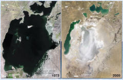
-Irrigation -Water diversion projects -Reservoirs: Artificial lakes used for hydroelectric power, municipal water, and stable agriculture |
|
|
Swamps and Marshes Surface Waters |
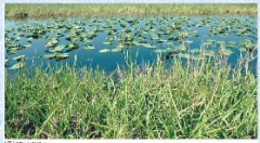
-Flattish places that are periodically submerged and shallow enough to permit plant growth -Swamps grow trees -Marshes grow grasses and rushes |
|
|
Rivers and Streams Surface Waters |
-Streams smaller than rivers -Geographers call all running water streams -Allow for drainage of land surface water towards oceans -Drainage basins |
|
|
Underground Water |

-Water beneath land surface worldwide -More than half found within 800 meters of the surface -Precipitation or water basins are the sources -Quantity held depends on porosity and permeability -Aquifers and aquicludes |
|
|
Zone of aeration Underground Water |
-Topmost band in underground water supply
-Water amount fluctuates rapidly with time |
|
|
Zone of saturation Underground Water |
-All pore spaces filled with water, called groundwater -Top of the zone is the water table -Water table intersects surface, water flows out (lakes, swamps, etc.) -Well water drawn faster than replenished creates a cone of depression -Lower limit has absence of pore spaces |
|
|
Zone of confined water Underground Water |
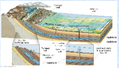
-Zone that exists in some regions that is below the region of impermeable rock below the zone of saturation -Pressure at the great depth of the water will cause water to rise to piezometric surface -Artesian well versus sub-artesian |
|
|
Waterless zone Underground Water |
-Pressure too great to sustain water |
|
|
Four regions of Earth’s |
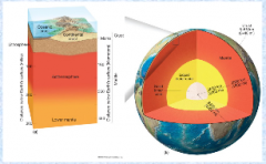
-Crust, mantle, outer core, inner core |
|
|
Crust The Structure of Earth |
-Depth of 5 km below ocean to near 20 km below land -Less than 1% of the Earth’s volume, 0.4% of Earth’s mass -Moho discontinuity: The significant change in mineral composition located at the base of the crust |
|
|
Mantle The Structure of Earth |
-Extends to depth of 2900 km (1800 miles)
-Largest of four shells
-Makes up 84% of total volume, 67% of total mass
-Three sublayers: Lithosphere, Asthenosphere, Rigid rocks (lower mantle) |
|
|
Outer core The Structure of Earth |
-Molten, extends to depth of 5000 km |
|
|
Inner core The Structure of Earth |
-Dense mass with radius of about 1450 km
-Primarily made of iron/nickel or iron/silicate
-Two zones combined make up 15% of the Earth’s volume and 32% of the Earth’s mass
-Magnetic field of Earth controlled by outer core
-Magnetic poles not the same as the axial poles |
|
|
Plate tectonics |
-Continental-sized plates slide along the asthenosphere |
|
|
Minerals |
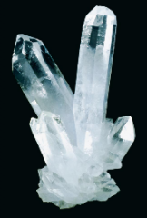
-Naturally formed compounds and elements of Earth Mineral characteristics: Solid, found in nature, Inorganic, specific chemical composition, contains atoms that arrange in patterns to form crystals |
|
|
Important crustal minerals |
-Silicates—combine oxygen and silicon, the most common elements in the lithosphere -Oxides—elements that are combined with oxygen -Sulfides—combination of sulfur and another element -Sulfates: contain sulfur and oxygen -Carbonates: light-colored minerals that are composed of a combination of carbon, oxygen and an element (i.e., limestone) -Halides: derived from word “salt”, salty minerals -Native elements: gold and silver
|
|
|
Rocks |
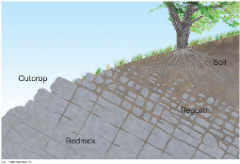
-Fewer than 20 minerals make up 95% of the composition of crustal rocks -Outcrops -Bedrock -Regolith -Petrology: characteristics of different rocks |
|
|
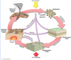
Igneous rocks |
-Igneous: “fiery inception” -Magma: molten rock beneath Earth’s surface -Lava: molten rock when it flows onto Earth’s surface -Pyroclastics -Classification of igneous rocks is based on mineral composition and texture -Texture based on how rocks cool |
|
|
Plutonic (intrusive) Two types of igneous rocks |
-Rocks cool beneath Earth’s surface
-Surrounding rocks insulate the magma intrusion, slowing cooling
-Individual minerals in a plutonic rock can grow to large size
-e.g. Granite |
|
|
Volcanic (extrusive) Two types of igneous rocks |
-Form on Earth’s surface and cools rapidly
-Generally do not show individual mineral crystals, but can if the crystals are formed from shattered rock that was explosively ejected
-e.g. Basal |
|
|
The Rock Cycle |
-Processes where rocks can transition from igneous rocks to sedimentary rocks to metamorphic rocks |
|
|
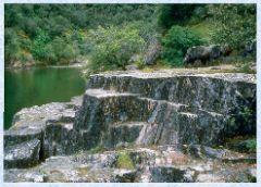
Sedimentary Rocks |
-External processes cause rock disintegration -Material transported by water as sediment -Over long periods, large amounts of sediment build to large thicknesses -Exert enormous pressure which causes particles in sediment to interlock -Chemical cementation takes place -Forms sedimentary rock -Strata: horizontal layers of sedimentary rock; sometimes tilted into vertical by Earth processes |
|
|
Clastic Two primary types of sedimentary rocks |
-Composed of fragments of preexisting rocks
-Also known as detrital rocks
-Shale is an example
-Conglomerate; composed of pebble-sized fragments |
|
|
Chemical and organic sedimentary rocks Two primary types of sedimentary rocks |
-Formed by precipitation of soluble materials or complicated chemical reactions
-Limestone and coal are examples
-Organic sedimentary rocks such as coal form from remains of dead plants and animals |
|
|
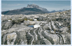
Metamorphic Rocks |
-Rocks which were originally igneous or sedimentary and have been changed by heat and pressure -Causes a “cooking” of rocks -Rearranges the crystal structure of the original rock -Contact metamorphism: rock contacts magma and is rearranged -Regional metamorphism: large volumes of rock are subjected to heat and pressure over long time scales -Limestone becomes marble; sandstone becomes quartzite, shale becomes slate |
|
|
Schist |
-Metamorphic rocks with narrow foliations |
|
|
Gneiss |
-Metamorphic rocks with broad, banded foliations |
|
|
Continental and ocean floor rocks |
-Sedimentary rocks make up 75% of the continents -Sedimentary cover is not thick -Continental crust: sial (silicon and aluminum) -Ocean floor crust: sima (silicon and magnesium) -Ocean lithosphere is more dense than continental lithosphere -Ocean crust can be subducted into the athenosphere |
|
|
Isostasy |
-Recognition of differences between oceanic crust, continental crust, and mantle |
|
|
Topography |
-The surface configuration of Earth |
|
|
Landform |
-Individual topographic feature of any size
-Elements of landform: structure, process, slope, drainage, relief |
|
|
Internal and External Geomorphic Processes |
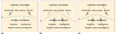
-Internal: originate from within Earth, increase relief of land surface
-External: originate from sources above the lithosphere, such as the atmosphere or oceans; decrease relief of land surface |
|
|
Uniformitarianism |
-“The present is the key to the past”
-Processes which shaped the landscape of the past are the same that will shape the future |
|
|
Geologic time |
-Vast periods of time over which geologic processes operate
|
|
|
The Evidence of Plate Tectonics |
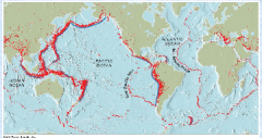
Plate boundaries: >Earthquakes occur along lines >Correspond with locations of trenches and ridges in the seafloor |
|
|
Seafloor Spreading Plate Tectonics |
-Midocean ridges formed by magma rising up from the mantle -New basaltic ocean floor created, moves away from ridge -At trenches, older lithosphere descends into the asthenosphere where it is recycled (subduction) |
|
|
Paleomagnetism Plate Tectonics |
-Iron in cooled magma orients itself with the magnetic poles of Earth -Provides a record of past magnetic fields -Magnetic field has changed orientation at least 170 times -Should be symmetry in magnetic orientation -Used to verify age of ocean floor rock and seafloor spreading
|
|
|
Plate tectonics |
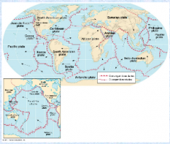
-Theory behind motion of lithospheric plates Plates float on asthenosphere -7 major plates, 7 intermediate plates, 12 smaller plates -Smaller plates are large plates that are being subducted
|
|
|
Driving plate tectonics |
-Slow convection in Earth’s mantle
-Convection can push plates away from each other
-Most motion results from plates pulled by subduction of dense oceanic lithosphere
-Ongoing area of research
|
|
|
Divergent boundaries Plate Boundaries |
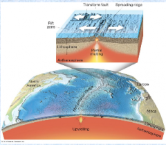
-Plates move away from each other -Asthenosphere wells up in the plate opening -Represented by a midocean ridge -Associated with shallow-focus earthquakes and volcanic activity -Constructive -Continental rift valley, proto-ocean |
|
|
Convergent boundaries Plate Boundaries |
-Collisions between plates
-Destructive
-Three primary collisions |
|
|
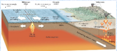
1.Oceanic-continental Convergent boundaries |
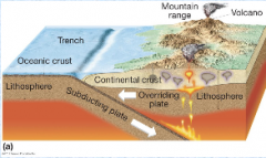
-Oceanic plate sinks since more dense; subduction
-Forms oceanic trench and continental mountains (i.e., Cascades, Andes) -Earthquakes occur along margin -Volcano formation along the plates—continental volcanic arc -Forms metamorphic rocks (blueschist) [left] |
|
|
2.Oceanic-oceanic Convergent boundaries |
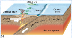
-Subduction results in undersea trench formation
-Deep and shallow earthquakes
-Island volcanic arc |
|
|
3.Continental-continental Convergent boundaries |
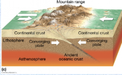
-No subduction since two plates are highly buoyant -Builds huge mountain ranges -Volcanoes are rare -Shallow earthquakes are relatively common |
|
|
Transform boundaries Plate Tectonics |
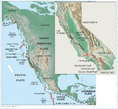
-Two boundaries slip past each other laterally -Transform faults -Neither creates nor destroys crust -Commonly produce shallow focus earthquakes -e.g. San Andreas fault |
|
|
The Rearrangement Plate Tectonics |
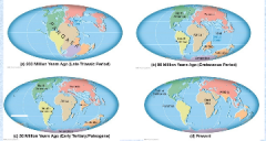
-450 million years ago, one supercontinent existed -Broke up 200 million years ago: Laurasia, Gondwanaland -Arrangement to the current continental configuration |
|
|
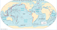
The Pacific Ring of Fire Plate Tectonics |
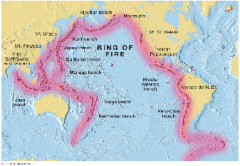
-Plate boundaries exist all around the Pacific Rim
-Primarily subduction zones
-75% of all volcanoes lie in the Ring of Fire |
|
|
Mantle plumes Additions to basic plate tectonic theory |
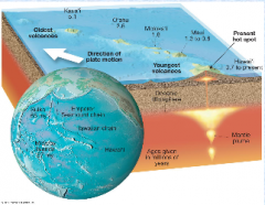
localized hot areas not associated with plate boundaries Move with the plate, so eventually become inactive Hot spot trail Hawaiian islands
|
|
|
Accreted Terranes Additions to basic plate tectonic theory |
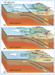
-Piece of lithosphere carried by a plate that eventually collides and fuses (accretes) with another plate |
|
|
The Questions Plate Tectonics |
-Midcontinental mountain range formation (i.e., the Appalachians) -Number of plates and plate sizes have changed over Earth’s history -Why are there earthquakes in the middle of continental plates? -Why are plates different sizes? -Why do plates form where they do? |
|
|
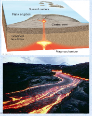
Volcanism |
-All phenomena connected to the origin and movement of molten rock -Extrusive volcanism: occurs on Earth’s surface, often shortened to volcanism -Intrusive volcanism: occurs below surface, plutonic activity |
|
|
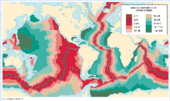
Global Volcano Distribution |
|
|
|
Magma chemistry and styles of eruption Volcanism |
-Nature of eruption determined by magma chemistry, also by confining pressure -Quantity of silica in magma is critical >High silica magma—felsic magma—granite : pyroclastic >Intermediate silica—andesitic magma—diorite : combination of the 2 >Low silica—mafic magma—basalt : quiet, nonexplosive |
|
|
Positives of Volcanic activity Volcanism |
-Relatively temporary features on the landscape -Much of Earth’s water originated from water vapor from volcanic eruptions -Magma contains major elements required for plant growth -Provides soil fertility |
|
|
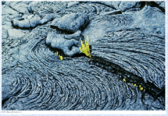
Lava Flows Volcanism |
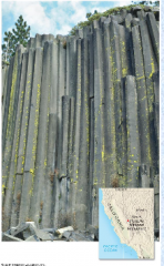
-Lava generally flows horizontally, parallel to the surface along which it flows -Eventually cools in horizontal orientation, strata -Streams flowing through lava flows result in irregular or fragmented surface -Uniform cooling results in hexagonal structure |
|
|
Flood basalt Volcanism |
-Most extensive lava flows come from hot spots -Flood basalt is a vast accumulation of lava build up -Correlated with mass extinctions; Dinosaurs! |
|
|
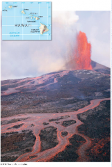
Shield volcanoes Volcanic peaks |
-Layer upon layer of solidified lava flows
-Little pyroclastic material
-Hawaiian islands are an example |
|
|
Composite Volcano Volcanic peaks |
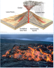
-Emit higher silica lavas (andesite lava) -Form symmetric, steep sided volcanoes -Pyroclastics from explosive lava flows alternate with nonexplosive flows -Pyroclastic flows produce steep slopes, lava holds it together
|
|
|
Lava domes Volcanic peaks |
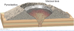
-Masses of very viscous lava that do not flow far -Lava bulges from the vent, dome grows by expansion from below and lava within -Some lava domes form inside of composite volcanoes |
|
|
Cinder cones Volcanic peaks |
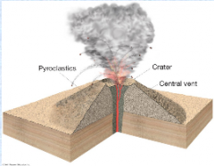
-Smallest volcanic mountains -Basaltic magma is common -Slopes form from pyroclastic materials -Generally found in association with other volcanoes |
|
|
Calderas Volcanic peaks |
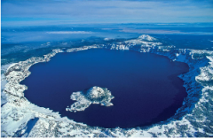
-Result from a volcano that explodes, collapses, or both -Immense, basin-shaped depression; larger than original crater -Crater Lake in Oregon is an example |
|
|
Volcanic necks Volcanic peaks
|
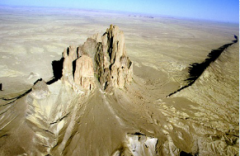
-Pipe or throat of an old volcano that filled with solid lava
|
|
|
Volcanic hazards Volcanism |
-Volcanic gases: mainly water vapor, but can cause acid rain and alter global climate -Lava flows: cause immense property damage -Eruption clouds: gas and ash material clouds that extend up to 16 km into the atmosphere, drop large rock fragments called “bombs” -Pyroclastic flows: avalanche of hot gases and material, up to 100 mph -Volcanic mud flows (lahars): result from heavy rain and/or snow melt during an eruption |
|
|
Monitoring volcanic hazards Volcanism |
-Research to locate previous pyroclastic flows and lahars
-Tiltmeters, measure the slope of a volcano to look for swelling
-Monitor earthquake activity |
|
|
Igneous features Volcanism |
-Igneous intrusion: rock formed beneath the Earth’s surface penetrates the crust (pluton) -Stoping -Scheme for classifying igneous intrusions -Batholiths: large, subterranean body of indefinite depth; important in mountain building -Stocks: similar to a batholith but much smaller -Laccoliths: slow-moving, viscous magma forced between horizontal layers of rock; builds up a mushroom shaped mass Dikes: vertical sheet of magma thrust upward into preexisting rock; long and narrow Sills: long, thin body whose orientation is determined by preexisting rocks Veins: molten material forces itself into smaller fractures in preexisting rock, takes irregular shapes
|
|
|
Diatrophism: Tectonism |
-Refers to the deformation of Earth’s crust
-Two primary types of diatrophism: folding and faulting |
|
|
Folding Diatrophism |
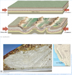
-Results when rock is subjected to lateral compression -Can take place on any scale -Can vary in complexity -Two types: >Anticline/upfold, can be forced to have reverse orientation, an overturned fold >Syncline/downfold: overthrust fold |
|
|
Faulting Diatrophism |
-Occurs when rock breaks accompanied by displacement -Occurs along zones of weakness in the crust, fault zones -Fault lines -Begin as sudden ruptures, but can result in large (hundreds of km) faults over millions of year -Fault scarps |
|
|
4 Types of Faults |
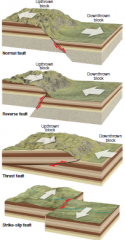
-Normal
-Reverse
-Thrust
-Strike-Slip Fault |
|
|
Fault-produced landforms Faulting |
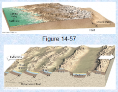
-Tilted fault-block mountains; one side of the fault block is tilted steeply relative to the other -Horst: uplift of a land block between two parallel faults -Graben: downthrown land block between two parallel faults |
|
|
Earthquakes Faulting |
-Vibration in Earth resulting from sudden displacement along a fault |
|
|
Earthquake waves Faulting |
-Energy released by earthquakes moves in several types of seismic waves that originate at the center of fault motion, the origin
-Ground above origin experiences strongest jolt, the epicenter
-P-waves versus S-waves |
|
|
Earthquake magnitude Faulting |
-Relative amount of energy released during an earthquake: >Logarithmic scale, 32nd power >Richter scale >Strongest recorded earthquake—9.5 in Chile |
|
|
The Complexities of Crustal Configuration |
-All these processes are interrelated -An example: Glacier National Park >Was below sea level for millions of years >Vast amounts of sedimentary rock >Igneous activity added variety to the sedimentary rock >Igneous intrusions created a sill and numerous dikes >Tremendous mountain building and associated uplift combined with lateral pressure from the west resulted in a vast rupture and faulting >Whole block moved by Lewis Overthrust >Had Precambrian sedimentary rock over Cretaceous strata |