![]()
![]()
![]()
Use LEFT and RIGHT arrow keys to navigate between flashcards;
Use UP and DOWN arrow keys to flip the card;
H to show hint;
A reads text to speech;
11 Cards in this Set
- Front
- Back
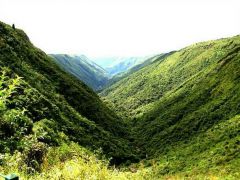
V-shaped Valley |
The river in the upper course contains large boulders which can erode the sea bed quickly when the river is in flood. This results in the river cutting downwards into its bed, a process called vertical erosion which forms the steep V-shaped Valley |
|
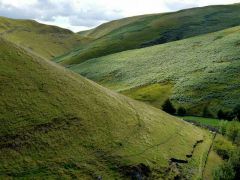
Interlocking spurs |
The rivers wind it's way around obstacles and the erosion is concentrated on the outside of the banks, this eventually creates spurs which alternate on each side of the river, so they interlock. |
|
|
Potholes |
Where is the bed is very uneven, pebbles carried by fast, swirling water can become trapped by obstacles. The swirling currents cause the pebbles to rotate in a circular movement, eroding circular depressions in the bed. |
|
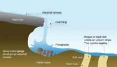
Waterfalls, gorges and rapids |
Waterfalls can form when the hard is horizontal and at the top. The lower softer rock is eroded more quickly causing the hard rock to overhang. The undercutting is caused by corrosion and hydraulic action. When the overhang becomes larger it collapses. The rocks crash down into the plunge pool and creates more erosion and makes the plunge pool deeper. This process repeated for a while, when the waterfall retreats, it leaves a steeped sided gorge. Sometimes thin bands of hard and soft rock cross the course of a river. The soft rock erodes and leaves an uneven river which forms rapids. |
|
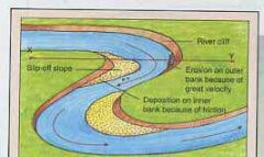
River cliffs and slip-on slopes |
The river in the middle and lower courses gains more forces and when they are meanders the water hits the outside of the meanders and widen the valley and erosion occurs. This eventually forms a river cliff. The current on the inside of the meander is slower as the river as the the river slows it drops some of its load and deposition occurs and a slip off is formed after a while. |
|
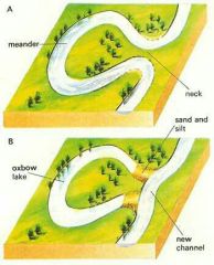
Oxbow lake |
As the river flows from its middle course to its lower course, the valley be me wider. Erosion continues to cut into the outside of the bends of a meander and a meander neck may form, which becomes narrower. Eventually when the river us in flood it may cut across the meander neck and shorten its course. For a while the water will still flow through both routes but the currents slows down and deposition occurs. The meander will be cut off from the new straight route leaving a oxbow lake. |
|
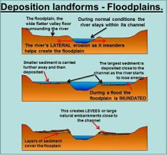
Flood plains and levées |
A flood plain is the area of almost flat land on both sides of a river. It is from when a river channel moves from one place to another. When the river is in flood the river is able to transport large amounts of materials in suspension. At times it will overflow the flood plains which causes the material to be deposited on the flood plains. When the flood is over it forms levées |
|
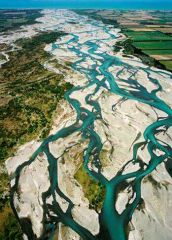
Braiding |
Braiding is when a river divides for various distances into two or more channels. The channels are separated by islands of sediment. Braiding occurs when a river carries a very large load particularly sands and gravel. |
|
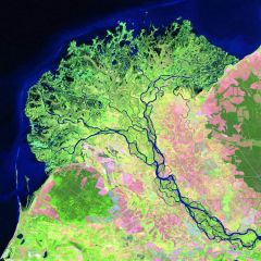
Deltas |
Deltas are formed by the deposition of sediment at the mouth of a river as it enters a sea or a lake. Deltas only form under certain conditions and most rivers do not end in a delta. |
|
|
The upper course |
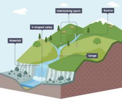
A steep V-shaped Valley, interlocking spurs, potholes, water, rapids and gorges. |
|
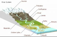
The middle and lower course |
River cliffs, slip off slops, meanders, oxbow lake, flood plains, levées, braiding and deltas. |