![]()
![]()
![]()
Use LEFT and RIGHT arrow keys to navigate between flashcards;
Use UP and DOWN arrow keys to flip the card;
H to show hint;
A reads text to speech;
114 Cards in this Set
- Front
- Back
|
Describe the shape of the earth |
Oblate Spheroid Equator slightly larger than poles |
|
|
Axis and Direction of rotation of earth |
Polar axis anti-clockwise |
|
|
Earths geographic vs magnetic poles |
Geographic are true poles Magnetic are offset and moving |
|
|
Describe a Great Circle |
A plane that passes through the center of the Earth -cuts the globe in half -the largest circle that can be drawn on the earth. |
|
|
What is the Equator an example of? |
A Great Circle (at right angles to the earths axis) - It bisects the globe |
|
|
Describe a Small Circle |
A plane that does not pass through the centre of the earth |
|
|
Describe a Meridian |
Also called Longitude Half of a Great Circle - NP -> SP Defined as E or W of Prime Meridian |
|
|
Describe a Latitude |
Also called Parallels Small circles that have their plane at angles to the Earth's axis Datum is the Equator |
|
|
Describe a Rhumb Line |
A regularly curved line on the earth's surface that cuts all meridians (Longitudes) at the same angle. This means you would follow a constant heading. Equator and meridians are technically rhumb lines that are Great Circles. |
|
|
Describe the Prime Meridian |
The meridian that passes through Greenwich (UK) |
|
|
Describe the 360 method of indicating the direction |
N = 000/360, S = 180 Expressed as a three-figure group 045 |
|
|
Describe the Earth's magnetic field |
Lines of magnetic flux rise from the North Pole and then travel toward the South before diving toward the South Pole. |
|
|
Define True North |
The North Geographic Pole. |
|
|
Define Magnetic North |
The North Magnetic Pole |
|
|
Define Compass North |
The North heading that is indicated by a compass subject to interference. |
|
|
Define the Cardinal Directions |
North, South, East, West |
|
|
Define the Inter-Cardinal Directions |
NE,SE,SW,NW Also called Quadrantal |
|
|
Define True Direction |
Measured with reference to the North Geographic Pole - Measured C/W from local meridian. |
|
|
Define Magnetic Direction |
Measured with reference to the North Magnetic Pole - When a needle is freely suspended it will align with the magnetic flux lines. The north-seeking end will point to the Magnetic North. This forms the datum for our magnetic direction. |
|
|
Define Compass Direction |
A direction that uses the Magnetic North heading, indicated from a compass (subject to interference) as a datum. |
|
|
Define Magnetic Variation |
The angular difference between True North and Magnetic North. Determined primarily by location, but also varies over time as the magnetic poles shift. |
|
|
Define Magnetic Dip |
Also known as magnetic inclination, refers to the angle formed between the direction of the Earth's magnetic field lines (flux) and the horizontal plane at a specific location. |
|
|
Define an Isogonal Line |
A dashed line that joins places that have the same Magnetic Variation. Typically printed at 1Degree intervals. |
|
|
Define an Agonic Line |
An Isogonal which is nil or Zero Variation |
|
|
Define Compass Deviation |
The deflection angle from Compass North to Magnetic North |
|
|
Variation Correction Summary |
Variation East - Magnetic Least Variation West - Magnetic Best |
|
|
Magnetic to True Summary |
True to Magnetic - Take off Variation Magnetic to True - Add on Variation |
|
|
Define True Bearing |
The angular difference from True North of a straight line drawn between two places. Either "To" or "From" |
|
|
Define Magnetic Bearing |
A true bearing that has had the Magnetic Variation either added or subtracted. |
|
|
Define Compass Bearing |
A true bearing that has had the Magnetic Variation and Compass Deviation applied. |
|
|
Saying for remembering conversion between True Magnetic and Compass |
TVMDC T-V Men Do Care True - Variation - Magnetic - Deviation - Compass |
|
|
Define Relative Bearing |
The bearing of an Object measured C/W in degrees from the nose of the A/C |
|
|
Define Clock Method Relative Bearing |
Each 5mins of Clock Face = 30 Degrees of Arc. N = 12, S = 6, E = 3, W = 9 |
|
|
What are the Processes, Cautions, and Limitations of deriving Track distances and Bearing from a chart? |
- Ensure latest, current edition chart - Ensure Ruler scale correct - Protractor Alignment - Apply Variation Correctly - Determine if Bearing is 'To' or 'From' - A DI bearing is Mag, Chart is True |
|
|
Define a Statute Mile |
Equal to 5280 feet or 1,760 yards - Non aviation unit |
|
|
Define a Nautical Mile |
Equal to 6080 feet or 1852m. 1 Minute of 1 Degree of Latitude at the centre of the earth. 1 nautical mile is defined as one minute of latitude measured along a meridian. |
|
|
Define a Kilometer |
Equal to 3280 feet. 1/10000th of the average distance between the equator and one of the poles. |
|
|
Define a Meter |
3.28 Feet or 3.3 Feet 1/1000th of a Kilometer |
|
|
Define a Foot |
0.304m |
|
|
Define a Knot (kt) |
1 Nautical Mile per Hour Std unit for airspeed |
|
|
Define Ground Speed (GS) |
Speed of A/C relative to the ground |
|
|
Define Indicated Air Speed (IAS) |
Speed value registered on ASI Important for calculating Aerodynamic performance |
|
|
Define Calibrated Air Speed (CAS) |
Indicated Air Speed corrected for Instrument Error and Pressure (position) error |
|
|
Define True Air Speed (TAS) |
The actual speed of the A/C through the air. Calibrated Air Speed corrected for air density. |
|
|
Explain the difference between Speed and Velocity |
Velocity is a vector - Therefore it is a vector quantity containing both Speed and Direction. Speed is simply an expression of how fast something is moving. |
|
|
Define Ground Position |
An A/C position over the ground |
|
|
Define Dead Reckoning (DR) Positions |
A Position over the ground that you will be at a certain time based on your calculated track made good and GS. |
|
|
Define a Fix |
The Geographical position of an aircraft at a specific time determined by visual reference to features on the ground, or by radio nav aids. |
|
|
Define Position Lines |
A line an A/C is known to be on at a particular time. I.E Power line or road. |
|
|
Describe Position Reports Using Place Names |
JFK Overhead Turangi |
|
|
Describe Position Reports Using Places/Distances/Bearings |
JFK 2nm to the East Turangi |
|
|
Describe a Location using Lat/Long |
Latitude first (Ruler Horizontal, Reading Vertical), then Longitude (Ruler Vertical, Reading Horizontal) Along the runway before takeoff |
|
|
Define Height |
The vertical distance of a level measured from a specified datum. Includes the vertical dimension of the object. |
|
|
Define Altitude |
The vertical distance of a level is measured from Mean Sea Level. Effected by atmospheric density |
|
|
Define Mean Sea Level |
ICAO Standard Atmosphere, pressure of 1013.25 hectopascals, and temperature of 15.0 degrees Celsius with a lapse rate of 6.5 degrees Celsius per 1000 M and is the altimeter sub-scale setting to obtain the elevation when on the ground. |
|
|
Define AMSL |
Above Mean Sea Level |
|
|
Define Ground Level |
The Altitude of the ground (Height 0) |
|
|
Define AGL |
Height above Ground Level |
|
|
Define Elevation |
Similar to Height (Height above datum) however, is commonly used to refer to things AMSL |
|
|
Define Pressure Altitude |
A surface of constant atmospheric pressure in terms of 100's of feet. Related to datum 1013.2Hpa Referred to as Flight Levels |
|
|
Define QNH |
Sea Level Pressure. When Altsmeter is set to QNH it reads Altitude. |
|
|
Explain the effect of a change in mean sea level air pressure on the altimeter reading of a transiting aircraft. |
If you travel from an area of High to Low the altimeter will overread Hi - Lo - Hi If you travel from an area of Low to High the altimeter will underread Lo - Hi - Lo Approx 1hpa = 30ft |
|
|
Explain the effect of a change in temperature on the altimeter reading of a transiting aircraft. |
If the air is warmer than ISA (15) the lapse rate (6 per 1000m or 2 per 1000ft) decreases. Therefore your altimeter will under reads (you are higher than indicated). In cold air the altimeter overreads / you are lower. |
|
|
State and apply the altimeter setting rules in New Zealand. |
(1) when operating at or above flight level 150, set altimeter to 1013.2 hPa: (2) when operating at or below 13 000 feet, set altimeter to the appropriate area QNH zone setting or aerodrome QNH altimeter setting: (3) when operating between 13 000 feet and flight level 150, set altimeter to the appropriate area QNH zone setting as advised by an ATC unit. |
|
|
Explain and apply the table of cruising levels |
North Odd plus 500 (270 - 089) South Even Plus 500 (090 - 269) Applies to magnetic Track, not HDG |
|
|
Define True and Magnetic Track Required |
The path the A/C actually takes over the Earth's surface. Can be either T or M depending on what was used to calculate it. |
|
|
Define Wind Velocity (W/V) |
The speed of the wind from a given direction. 270/26 (Vector) Metservice T ATIS M UNICOM M |
|
|
Define Head / Tail Wind |
Headwind = TAS - H/W = GS Tailwind = TAS + T/W = GS |
|
|
Define Crosswind |
Wind that crosses your Track |
|
|
Define True Heading |
A/C HDG with reference to True North |
|
|
Define Magnetic Heading |
A/C HDG with reference to Magnetic North (Variation) |
|
|
Define Compass Heading |
A/C HDG with reference to Compass North (Deviation)
|
|
|
Define Drift - Planned and Actual |
Drift - The angular difference between HDG and TR Planned The drift calculated during the planning phase Actual The drift that actually occurs during flight |
|
|
Define Track Made Good (TMG) |
The actual track or path of the A/C expressed in degrees T or M |
|
|
Define Port |
Lefthand Side |
|
|
Define Starboard |
Righthand Side |
|
|
Define Wind Correction Angle |
The correction angle to allow for drift to fly a flight planned or required track. |
|
|
Define Wind Angle |
The angle between the wind direction and TR |
|
|
Define Deduced (Dead) Reckoning |
An estimate on where the A/C will be at various stages of the flight |
|
|
Define Track Error (TE) |
The angle between the Required Track TR and the TMG |
|
|
Define Closing Angle (CA) |
The angle that will bring you back onto your intended Track |
|
|
Define Estimated Time of Departure (ETD) |
The start point for your flight planning is always in UTC |
|
|
Define Actual Time of Departure (ATD) |
The time you actually depart vs the planned time. In UTC |
|
|
Define Estimated Elapsed Time (EET) |
The estimated time from the first point of the route to which the flight plan applies to the termination point of the flight plan. Changes as GS changes. |
|
|
Define Estimated Time of Arrival (ETA) |
The estimated time that you reach the nominated point. Worked out from ETD and EET. In UTC |
|
|
Define Estimated Time of Arrival (ATA) |
The time you actually Arrive vs the planned time. In UTC |
|
|
Explain the 1 in 60 Rule |
1nm in 60nm = 1 degree 1nm subtends an angle of 1 degree at 60nm 60 / Dist Gone = TE / Dist Off TE = 60 / Dist Gone x Dist Off CA = 60 / Dist To Go x Dist Off |
|
|
Describe the six-figure systems of indicating date/time groups |
Contains the Day of the month in 2 figures and the time in 4 figures. 12th @ 1600 = 121600 |
|
|
Define Coordinated Universal Time UTC |
Greenwich Mean Time (GMT). Aeronautical Reference Time for New Zealand. 12 hours behind NZST and 13 behind NZDT |
|
|
Define Standard Time (NZST) |
Time reference for the entire country 12 hours ahead of UTC |
|
|
Define Daylight Time (NZDT) |
During the period of daylight saving NZST becomes NZDT 13 hours ahead of UTC |
|
|
Define Sunrise |
The precise time when the upper limb of the sun (the first visible part) is on the visible horizon |
|
|
Define Sunset |
The precise time when the upper limb of the sun (the last visible part) disappears below the visible horizon |
|
|
Define Daylight |
The period between the start of MCT and the end of ECT |
|
|
Define Twilight |
Periods of quasi-light. From MCT to Sunrise and Sunset to ECT |
|
|
Define Morning Civil Twilight (MCT) |
Occurs when the center of the sun is 6 degrees below the sensible horizon. No VFR ops before this time |
|
|
Define Evening Civil Twilight (ECT) |
The end of ECT occurs when the center of the Sun is 6 degrees below the sensible horizon. VFR ops cease by this time. |
|
|
Describe the factors that affect the times of sunrise and sunset (daylight) |
Altitude and Atmosphere Conditions. Days are longer and nights shorter at height. Large obstructions can affect the clarity and brightness. |
|
|
Describe the factors that affect the duration of twilight.
|
Altitude - the higher you fly the earlier the start of MCT and later the end of ECT Bigger angular difference between sensible and visible horizons. |
|
|
Describe the factors that affect daylight conditions. |
Higher altitudes mean that daylight is longer Bigger angular difference between sensible and visible horizons. |
|
|
Define scale and the relationship between chart and earth distances |
Chart scale is defined as the ratio of a given chart length to the actual distance on the earth that it represents. Scale = Chart Length / Earth Distance |
|
|
Describe the appropriate use of NZ Aeronautical Charts |
Visual Planning Charts 1:1,000,000 Visual Navigation Charts 1:500,000 VNC Enlargements 1:250,000 Contains- Topographical, Cultural, Aeronautical, and Isogonal Information. |
|
|
Describe the appropriate use of Visual Aerodrome Charts |
Published in AIP Vol4 Contains detailed information on Aerodromes |
|
|
Describe the method of indicating relief on a NZ Aeronautical Chart. |
Hypsometric tint table for assigning heights to colors |
|
|
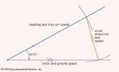
Identify and label the three vectors of the triangle of velocities |
|
|
|
State the two types of radar currently used in New Zealand |
Primary surveillance radars (PSRs) locatedat Auckland, Wellington, and Christchurchgive limited coverage depending on terrainand altitude. The secondary surveillanceradar (SSR) network covers much of theNorth Island and the north and east of theSouth Island. |
|
|
Describe the method of operation of each type of radar |
Primary surveillance radar – uses radarechoes to detect position. Secondary surveillance radar – usesaircraft transponders to respond toground equipment interrogation andidentify aircraft. This equipment can use the transmitted informationto ascertain the aircraft altitude if theaircraft transponder is selected to‘Altitude Mode/Mode C’. |
|
|
Explain what is meant by transponder Mode A and Mode C |
Mode A(identification and position) and ModeC (altitude) |
|
|
List and explain radar services that may be available to VFR flights |
Separation? |
|
|
Explain the limitations of using GPS/GNSS to supplement normal visualnavigation. |
Under Visual Flight Rules the GPS should only be used as a supplement to visual navigation |
|
|
Explain the limitations of using GPS/GNSS to supplement normal visualnavigation. |
Do not rely on GPS. Know your position and confirm it from visual observations of POI and map. Multipath error - signals bouncing around Tropospheric error- water molecules Ionospheric error - charged particle Receiving error - pseudo-random code match Human Errors |
|
|
Describe the procedures and techniques to safely manage the fuel for a givenflight. |
1. Fuel Planning 2. Fuel Calculation 3. Fuel Monitoring |
|
|
Describe the requirements and procedures to manage SARTIME. |
File a flight plan with the National Briefing Office (NBO), which includes the SARTIME, estimated time of departure (ETD), route, and estimated time of arrival (ETA) |
|
|
What happens when SAR time is reached? |
SAR activated. |