![]()
![]()
![]()
Use LEFT and RIGHT arrow keys to navigate between flashcards;
Use UP and DOWN arrow keys to flip the card;
H to show hint;
A reads text to speech;
19 Cards in this Set
- Front
- Back
|
What are the warning signs of a TRS? |
1) The swell will arrive well in advance of clouds, pressure changes ect. The direction of the swell will indicate the direction of the storm. 2) A change in intensity or direction of the trade winds. 3) The barometric pressure being more than 3mb below the seasonal normal for the particular region and time of day. 4) An oppressive atmosphere with increasing humidity. 5) An ugly lurid sky at sunset and sunrise. 6) As the storm gets closer other observations will include Cirriform Clouds in thick spiral bands. 7) Pressure: 500m - 120m from the centre SLOW FALL 120m - 60m from the centre DISTINCT FALL DIURNAL VARIATION MASKED 60m - Centre RAPID FALL |
|
|
Which time of year would you expect to come across a TRS whilst navigating to the south of Florida? |
August to October |
|
|
Which time of year would you expect to come across a TRS when navigating in or the the Bay of Bengal/ South China Sea? |
June to November |
|
|
What weather would you expect to experience as a cold front approaches? |
Heavy rain is possible as the front approaches until just after it passes. |
|
|
What weather would you expect to experience as a cold front passes? |
The air will be cooler and drier than the air before the front. The wind increases and veers. |
|
|
What weather would you expect to experience as a warm front approaches? |
Light rain or light winter precipitation is possible due to the warm air being slowly lifted as it passes over the cold sector in front. As the water content condenses as the air rises Nimbostratus will form turning into altostratus giving way to light precipitation. |
|
|
What weather would you expect to experience as the warm front passes? |
The air mass behind the warm front is likely to be warmer and more moist than the cold air ahead of it. You can expect clearer skies and higher relative humidity behind a warm front. High Cirrus clouds will remain after the warm front has passed. |
|
|
What weather would you expect to experience as an occluded front approaches? |
Rain or snow. Possibly thunderstorms. |
|
|
How does a Warm Occlusion Occur? |
If the cold front rises over the warm front it is called a warm occlusion. |
|
|
How does Cold Occlusion Occur? |
If the cold front undercuts the warm front it is known as a cold occlusion. |
|
|
What is an Anti-Cyclone? |
They are an area of high atmospheric pressure where the air is sinking. As the air is sinking no clouds are formed and as the air warms it holds more water. The absence of fronts mean the wind can be very light. |
|
|
What weather would you associate with an Anti Cyclone? |
In summer, anticyclones bring dry hot weather. In Winter, anticyclones may bring clear skies and frost. |
|
|
What is Frontolysis? |
The dissipation or weakening of an atmospheric front. |
|
|
What is frontogenesis? |
Forming as a result of a baroclinic wave this causes the tightening of the horizontal temperature gradient resulting in the formation of a warm and a cold front. |
|
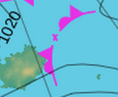
What is this? |
This is frontolysis, this represents a weakening front which is losing it's identity. Usually due to rising pressure. Cloud and precipitation become increasingly fragmented. |
|
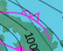
What is this? |
This is an upper front, this represents the boundaries between air masses at levels above the surface. For instance the passage of an upper front may bring warmer air at an altitude of 10,000ft without bringing a change of air mass at the surface. |
|

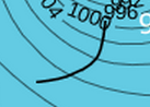
What is this? |
This is frontogenesis - This represents a front that is forming due to an increase in pressure gradient at the surface. |
|
What is this? |
An elongated area of relatively low surface pressure. May also represent an area of low thickness or a perturbation in the upper troposphere. All are associated with increasing crowd and risk of precipitation. |
|
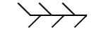
What is this? |
A slow moving trough which runs parallel to the isobars and tends to be persistent over many hours or days. They are quite common over cold northerly outbreaks over the Irish sea, affecting west Wales, Devon and Cornwall in particular. Can give hours of persistent precipitation over localized areas, whilst a few miles down the road it is relatively dry. |