![]()
![]()
![]()
Use LEFT and RIGHT arrow keys to navigate between flashcards;
Use UP and DOWN arrow keys to flip the card;
H to show hint;
A reads text to speech;
53 Cards in this Set
- Front
- Back
|
Where is icing worst in a cloud/CB? |
The first 6-8000ft above the freezing level, and in warmer regions (as warm air hold more water). Clear ice will form in this zone due to supercooled water droplets. |
|
|
How long is a sigmet valid? |
4hrs |
|
|
How long is a volcanic sigmet and TC sigmet valid for? |
6hrs, outlook for 12 |
|
|
When is a sigmet reviewed? |
Every 3 hours |
|
|
What is worse, Kata or ana CB? |
Ana type, it's steeper and more unstable. Often has CB with anvil. |
|
|
What happens to pressure during passage of a warm front? |
Decreases, low, stay same or slight increase |
|
|
Pressure with passage of cold front? |
Decrease, low, increase |
|
|
What is an inter? |
Temp change in the weather lasting no longer than 30min in each instant, over the period given. |
|
|
What's a tempo? |
Temp change in the WX lasting no longer than an hour in each instant |
|
|
What is PO in a TAF? |
Dust or sand whirls |
|
|
BR in TAF? |
Mist |
|
|
FU in TAF? |
Smoke |
|
|
VA in TAF? |
Volcanic ash |
|
|
DU in TAF? |
Wide spread dust |
|
|
FC in TAF? |
Funnel cloud |
|
|
GS in TAF? |
Small hail or snow pellets |
|
|
PL in TAF? |
Ice pellets |
|
|
IC in TAF? |
Ice crystals |
|
|
SG in TAF? |
Snow grains |
|
|
MIBR in TAF? |
Shallow mist |
|
|
BCFG in TAF? |
Fog patches |
|
|
PRBR in TAF? |
Partial mist |
|
|
BLSN TAF? |
Blowing snow |
|
|
DRSN in TAF? |
Drifting snow |
|
|
How strong does the wind need to be to be called a Jetstream? |
Greater than 60kt |
|
|
What are the kinds of jet stream? |
Polar jet (both hemispheres) Sub tropical jet (both hemispheres) |
|
|
What side of an airmass is the JS? |
Lies in the warm sector/side. |
|
|
What causes a Jetstream? |
A strong temperature gradient between airmasses. Therefore often associated with fronts. |
|
|
Which jet is higher in altitude? |
Sub tropical jet, Polar is lower |
|
|
Mean alt of subtropical jet? |
40000ft - 200hpa, lies over Japan |
|
|
Height of Polar jet? |
30000ft - 300hpa |
|
|
Which jet moves N/S the most? |
The polar jet |
|
|
When are jets strongest? |
Winter |
|
|
What is needed for radiation fog? |
Caused by a cold surface making air above cold, loss of terrestrial radiation.
A clear sky High RH Light wind Stable atmosphere (keep everything down) |
|
|
What causes advection fog? |
Involves an already already cold surface, in which moist air moves over and then forms fog as it cools. |
|
|
Where would you find frontal fog? |
Associated with a warm front, but in the cold sector ahead of it. |
|
|
Where is fzra most likely to occur? |
In the cold sector below a warm front, as precipitation falls as rain, then enters the cold air and freezez on impact as droplets are supercooled. Often associated with a temp invwrsion. |
|
|
Where does a jet stream lie in terms of cold and warm fronts? |
Behind the cold front and ahead of the warm front |
|
|
What are ISA conditions? |
1013.25 HPA 15c 1.98 per 1000ft, to 36090ft, then -56.5 9.8m/s 1.225kg/m3 |
|
|
Jet standard atmosphere? |
2 degrees per 1000ft with no tropopause |
|
|
Symptoms of wind shear? |
Rapid speed fluctuations +-15kt, large pitch changes, VS outside of normal perameters, airspeed stagnation on takeoff, abnormal thrust settings and turbuoence. |
|
|
What is a microburst? |
Vertical downdraft of up to 6000ft/min. Cause gust fronts up to 2km ahead and behind, up to 2000ft. Can come from a high cloud base. As precipitation falls it evaporates, requiring latent heat. This rapidly drops the temp of the air making it more dense, and as a consequence increases its rate of descent to earth. |
|
|
How is gust factor calculated? |
Wind range / mean wind. Eg 15kt g 25kt would be 10/20 so a gust factor of .5 |
|
|
What are the sigwx symbols? |
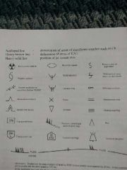
|
|
|
What does CAVOK mean? |
No cloud at all below 5000ft or MSA (higher of), viz 10 km or greater and no CB or thunderstorms, and no precipitation. MSA AA. 5000 WN 6500 CH. 7000 |
|
|
What is a trend forecast? |
A part added on to the end of a metal, stating the part of the TAF that is shortly due to take place, like a tempo or BCMG. Valid for 2 hrs |
|
|
When is RVR used? |
When viz is less than 1500m |
|
|
Where is turbulence worst in a thunderstorm? |
The mature stage due to the presence of up and down draughts. Downdrafts occur at the front of a mature CB, updraughts at back. |
|
|
Where does the Jetstream lie around fronts? |
Ahead of the warm and behind the cold front |
|
|
Where is the worst CAT in a jet? |
Level or just higher than the core, in the warm air but on the cold side |
|
|
What is the ITCZ |
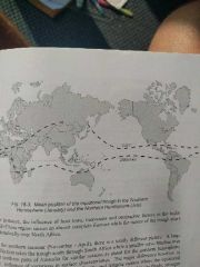
It is a place of trade wind convergence, near the equator. It is transient in nature and follows the sun North and South. Its movement tracks move to land than sea, as sea doesn't generate as much heat. WX is CB, CU or clear, but can change rapidly. |
|
|
What is a speci? |
Issued as an amended metar, when weather values change above a predetermined value. Improvement reported when has been so for 10 or more minutes. |
|
|
When are mid and stop end RVR given? |
Only when less then TDZ, or below 600m |