![]()
![]()
![]()
Use LEFT and RIGHT arrow keys to navigate between flashcards;
Use UP and DOWN arrow keys to flip the card;
H to show hint;
A reads text to speech;
50 Cards in this Set
- Front
- Back
|
Slope guidelines |
0-1% Flat with potentially poor drainage - buildings, play, sports 2-5% Acceptable for structures, play areas, sports fields 6-15% okay for some structures and some free play activities >15% generally not considered buildable |
|
|
ANSI nursery stock standard sections |
1: General Standards 2: Shade and flowering trees 3: Deciduous shrubs 4: Coniferous Evergreens 5: Broadleaf Evergreens 6: Roses 7: Young plants 8: Fruit trees 9: Small fruits 10: Understock 11: Seedling trees and shrubs 12: Bulbs, corms, tubers 13: Herbaceous perennials, ornamental grasses, groundcovers, and vines 14: Christmas tree standards |
|
|
ANSI plant container size equivalents |
The volume ranges for containerclasses #1 through #100 include the volume of a container that, if such a container weremanufactured, would hold the equivalent number of gallons as the container class number. containers commonly referenced in the industry as “four inch” or “quart”containers are #SP4 containers (1 qt. = 57.75 cubic inches). |
|
|
General requirements for all nursery stock |
-Must be correctly identified by genus, species, and cultivar if applicable -All nursery stock transacted within the terms of the Standard shall, at time of shipment, besubstantially free of damaging insects and diseases, in good living condition, and typical inhabit for the species in the region of the country in which it is grown. -Type 1 and 2 shade trees should not have co-dominant stems (i.e. should only have one leader) -In general, the root ball or root spread should be greater for collected or plantation grown plants than for nursery grown plants -Root flair should be visible above the soil |
|
|
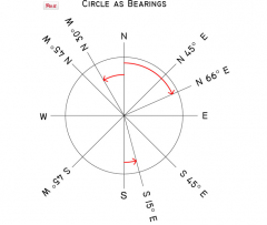
Coordinate system bearings |
|
|
|
Point of beginning |
The point of beginning is a surveyor's mark at the beginning location for the wide-scale surveying of land. |
|
|
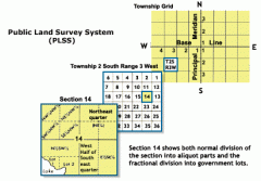
PLSS grid system |
|
|
|
Bench mark |
In surveying, a "bench mark" (two words) is a post or other permanent mark established at a known elevation that is used as the basis for measuring the elevation of other topographical points. |
|
|
Cartesian coordinate systems |
A Cartesian coordinate system is a coordinate system that specifies each point uniquely in a plane by a pair of numerical coordinates. State Plane coordinates are an example |
|
|
Plane vs geodetic surveying |
Plane surveys are the most commonly practised method of surveying and treat the earth as a flat or "plane" surface. Good enough for small-scale surveys in limited areas, the curvature of the earth has no effect on the results, thus the computations and results can be referenced to a plane or flat surface. Geodetic Surveys are surveys, which take into account the true shape of the earth. Geodetic surveys are typically carried out with great precision, often over long distances, and are used not only to determine the size, shape and gravity field of the earth. |
|
|
UTM coordinates |
geographic survey coordinate system that uses metric units. Each zone is covers 6 degrees of longitude |
|
|
Organization that keeps a record of archaeological sites in the US |
National Register of Historic Places (managed by the NPS) |
|
|
What makes up the contract documents? |
Working drawings Specifications General conditions Agreement form |
|
|
Critical path method |
project management technique used by contractors to determine site construction sequencing. The goal is to determine the longest linear sequence of events that cannot be completed simultaneously, which determines the minimum length of time to construct the project. |
|
|
PERT |
Program Evaluation Review Technique. May be illustrated with a bar chart that highlights the critical path. Weekly or daily review of the PERT helps keep a project on track to be completed on time. |
|
|
Bulldozer |
Best for moving earth over short distances (<200 ft) or areas with limited maneuverability. |
|
|
Scrapers (2 types) |
Move earth more efficiently than a bulldozer but with limited mobility. Bottom mounted scraper versions are usually pushed by a bulldozer. Elevating paddlemounted scrapers are often self-propelled. |
|
|
Power shovels |
Elevating arm, much smaller than a bulldozer. Used on steep embankments or to reach areas too narrow for other machines |
|
|
What comes first in earthwork: Subgrades or trenching and basements? |
Subgrades are usually set before trenching and basements take place |
|
|
Main categories of earthwork operations |
Cut Fill Trenching Bulk excavation |
|
|
Equipment for trenching |
A backhoe can be used for utility trenches on most jobs. For large jobs a power hoe or even a chain or wheel trencher may be used. Larger trenches may require slip form bracing to prevent wall collapse. |
|
|
Controlled fill placement |
Placing fill in lifts with a bulldozer (smaller jobs) or scraper (larger jobs) and compacting to the specified density (usually 95%) so that the rate of infiltration and bearing capacity will resemble that of "undisturbed earth" |
|
|
Clay soil compaction |
Cohesive soils commonly compacted using a tractor drawn sheepsfoot roller. High density compaction requires 8-12 passes. |
|
|
Granular soil compaction |
Must be rolled and vibrated using steel or rubber tire rollers. Typically 4-6 passes. |
|
|
Structural fill |
typically placed under building floor slabs, requiring stringemtn placement and compaction. Placed in 6" lifts vibrated and rolled to achieve 95% density |
|
|
How much soil cover is typically needed to prevent thin wall pipe crushing? |
30" |
|
|
Typical depth of buried electrical |
2 ft |
|
|
Adjacency of telecommunication and electrical lines |
Typically must be separated to avoid magnetic field interference |
|
|
Precision of rough grading under hardscape slabs |
Typically 1/2" |
|
|
Finish grading |
Placement of topsoil between hardscape and structure |
|
|
Demolition process - key steps |
1. Preliminary layout survey and staking *if layout needs to be different than design drawings may need adminstrative approval* 2. Limit of work line 3. General demollition: Take out everything that shouldn't be on the site and is being completely removed 4. Selective demolition: removal contaminated structures and saw or torch cutting 5. Clearing and grubbing 6. Selective clearing 7. Tree and stump disposal 8. Topsoil stripping and stockpiling |
|
|
When is degree of slope used in earthwork? |
Large-scale earth-moving projects like strip mining or other extraction activities |
|
|
Baseball field grading |
Grade typically climbs about 8" from bases to bottom of pitchers mound. Top of pitchers mound is 15" above bases. (Assumes 127' 3 3/8" from outside of 1st to outside of 3rd base, 18' dia. pitchers mound) 3 typical grading schemes: -Sloping away from the pitchers mound, 1 HP -Ridgeline from pitchers mound to outfield, drain to corners -Saddle just beyond infield with 2 HPs-one on pitchers mound on in outfield. Slopes in all cases 1% except pitchers mound side slopes See 320-16 TSS for diagrams |
|
|
Football field grading |
Crowned surface sloping from center of field ridgeline to drainage system beyond sidelines (Figure pg 320-18 TSS) |
|
|
Soccer and Field hockey grading |
Can be played on crowned football field or can slope in one direction at 1% |
|
|
Basketball court grading |
Slope 1% from one sideline to the other (overall dimensions 94' x 50' |
|
|
Tennis court grading |
Slope from net to ends of court. Two tilted flat surfaces, 0.5% slope |
|
|
Swale vs ditch |
Swales have gradual (<3:1) slopes and a parabolic cross section. Ditches have steeper slopes and a narrower deeper cross section |
|
|
Velocity when swales start to erode |
4 ft/s for kentucky bluegrass swales, 6 ft/s for fescue swales. Beyond 6 ft/s a nonvegetative material should line the swale |
|
|
What does it mean to age a drainage ditch? |
Allow time to increase the density and stability of the channel material through the deposit of silt in interstitial space and the cementation of the soil by colloids |
|
|
Should design velocities in a drainage channel be faster or slower if the water is routinely <6" deep |
Slower |
|
|
Maximum tread ratio for outdoor stairs |
2:1 tread to riser |
|
|
What can be steeper, the longitudinal or cross slope of a parking lot |
The cross slope (max 10%, min 0.5). Slopes >5% on the longitudinal slope can cause car doors to swing open and hit other cars. Also a farther distance for stormwater to travel. Min. longitudinal slope is 0.25% |
|
|
Define swell; Formula to calculate percentage swell of excavated bank |
Swell is when material is excavated and the volume of the material increases (i.e. becomes less dense); SW=((B/L)-1)x100 where B=weight of undisturbed bank in a unit of volume and L=weight of loose earth in same unit of volume (i.e. kg/m^3 or lbs/cu yd) |
|
|
Define shrink; Formula to calculate percentage shrink of excavated material after nominal compaction |
Shrink is when excavated material is compacted and the density is greater than in the original bank; Sh=(1-(B/C))x100 where B=weight of undisturbed bank per unit of volume and C=Weight of compacted earth in same unit of volume (i.e. kg/m^3 or lbs/cu yd) |
|
|
Borrow Yard |
A cubic yard of unexcavated material. Used as a reference unit to calculate swell of stockpiled material and/or shrink of replaced material |
|
|
What is the legal accuracy of contours on a survey map |
1/2 of the contour interval |
|
|
What is the typical accuracy of surveyed spot elevations? |
0.1 ft |
|
|
How far apart are latitude lines? |
69 miles |
|
|
How far apart are longitude lines? |
69 miles at the equator |