![]()
![]()
![]()
Use LEFT and RIGHT arrow keys to navigate between flashcards;
Use UP and DOWN arrow keys to flip the card;
H to show hint;
A reads text to speech;
80 Cards in this Set
- Front
- Back
- 3rd side (hint)
|
By David & Ewan 7W |
Please zoom in to see pictures! |
|
|
|
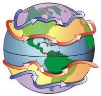
Describe how water turns into cloud in the water cycle (hydrological cycle). |
|
Water vapour comes from the sea and lakes but also plants. |
|
|
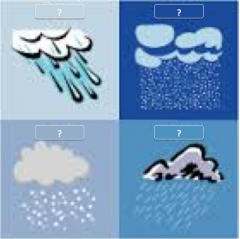
Describe how and in what form precipitation occurs in the water cycle. |
As the clouds rise further and cool, precipitation will occur in the form of rain, hail, sleet or snow. |
https://www.youtube.com/watch?v=T05djitkEFI |
|
|
Describe what happens to the water once it has fallen in the water cycle. |
|
There are 5 different options – here are some key words for each one:
|
|
|
10 reasons we study the weather? |
|
What would happen if you could not predict or understand the weather? What impact would this have on your life or the life of others? |
|
|
Explain the steps of convectional rainfall. |
|
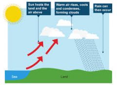
Any form of water evaporating, condensing and precipitating. |
|
|
Explain the steps of relief rainfall |
|

Involves a hill. |
|
|
Explain the steps of frontal rainfall. |
|
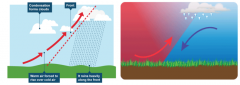
Involves two air masses of different temperatures. |
|
|
5 factors affecting temperature? |
|
|
|
|
How does latitude affect temperature? |
|
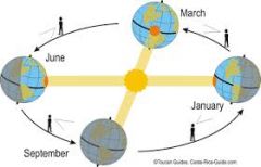
The earth has a tilt of 23.5˚. How could this affect temperature? |
|
|
How does altitude affect temperature? |
The temperature falls by approximately 1˚c for every 150m you ascend. |
Why does the moisture in the air condense to form clouds? |
|
|
How does distance from the sea affect temperature? |
|
The sea retains temperature for longer than the land. |
|
|
How do ocean currents affect temperature and why? Give an example. |
|
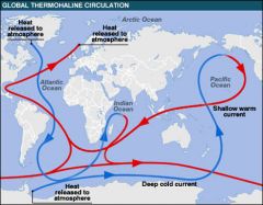
What does the gulf stream do and why? |
|
|
How does prevailing wind direction affect temperature? Give an example. |
|
Think of where the wind is coming from. |
|
|
Air mass |
A large body of air showing common temperature and humidity characteristics. |
|
|
|
Altitude |
Height in relation to sea-level |
|
|
|
Aspect |
The compass direction the slope faces |
|
|
|
Atmosphere |
Gasses surrounding the Earth |
|
|
|
Climate |
The overall pattern of weather in a particular area over an average of 30 years. |
|
|
|
Condensation |
|
|
|
|
Depression |
Areas of low atmospheric pressure. |
|
|
|
Dew point |
The point at which air condenses into clouds. |
|
|
|
Drought |
A prolonged period of abnormally low rainfall. |
|
|
|
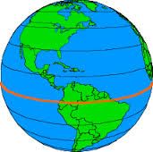
Equator |
The line of latitude at 0˚ |
|
|
|
Evaporation |
Heat forcing solid into liquid and liquid into gas |
|
|
|
Fog |
Low lying stratus cloud that decreases visibility. |
|
|
|
Isotherms |
Isotherms are lines joining areas of equal temperature. 'Iso' means 'the same' in ancient Greek. |
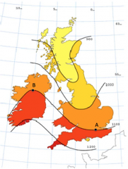
Locations A and B are of equal temperature. (Zoom in to see picture) |
|
|
Hemisphere |
a half of the earth divided into northern and southern halves by the equator |
|
|
|
Humidity |
atmospheric moisture |
|
|
|
Infiltration |
When water on the ground enters the soil |
|
|
|
Interception |
Precipitation that is prevented from reaching the ground often by trees. |
|
|
|
Irrigation |
Artificial application of water to land or soil. |
|
|
|
Microclimate |
The climate of a small area. |
An example is Hyde Park |
|
|
North Atlantic Drift |
A continuation of the Gulf Stream heading northeast. |
|
|
|
Percolation |
The movement of water through the soil or underlying porous rock. This water collects as groundwater. |
|
|
|
Precipitation |
Water falling from the atmosphere to the ground in a solid or liquid form. |
|
|
|
Prevailing wind |
Most frequent wind direction a location experiences. |
|
|
|
Rainshadow |
Dry area on the leeward side of a mountainous area due to precipitation evaporating as it falls and temperature increases. |
|
|
|
Surface run-off |
Rapid flow of water on the land. |
|
|
|
Throughflow |
Flow of water through something. |
|
|
|
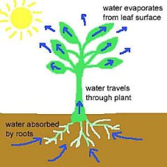
Transpiration |
The process by which water is carried through plants and expelled as water vapour into the atmosphere. |
|
|
|
Weather |
Day to day, hour by hour state of the atmosphere. |
|
|
|
Weather front |
A boundary separating 2 masses of air. |
|
|
|
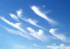
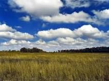
Name the 3 main types of cloud |
|

|
|
|
Describe any 3 characteristics of cirrus clouds |
|
|
|
|
Describe any 3 characteristics of cumulus clouds |
|
|
|
|
Describe any 3 characteristics of stratus clouds |
|
|
|
|
Why are temperatures in January warmer on the west coast of the Britain? |
The North Atlantic drift is a warm ocean current that brings higher temperatures to the west of the UK. The North Atlantic drift originates in the Gulf of Mexico. |
Think about ocean currents affecting Britain. |
|
|
What type of climate does Britain have and what is it? |
|
Does Britain have a:
|
|
|
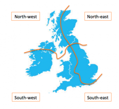
Describe the different climates of the 4 quarters of the British Isles (NE, NW, SE, SW) |
North-east:
North-west:
South-east:
South-west:
|
|
|
|
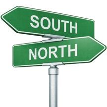
Give 2 reasons why the South of Britain is warmer than the North? |
|
What factors affect temperature? Do any of them fit this example? |
|
|
Why is there more rainfall in the west of Britain? |
|
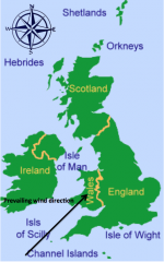
The prevailing wind direction comes from the south-west. |
|
|
Name what one measures with these instruments and what it is measured in. |
Name what one measures with these instruments and what it is measured in. |
|
|
|
Thermometer |
Temperature ˚c |

|
|
|
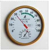
Hygrometer |
Humidity % |
|
|
|
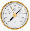
Barometer |
Pressure % |
|
|
|
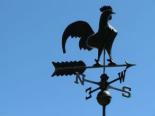
Wind vane |
Wind direction Compass points |
|
|
|
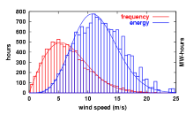
Anemometer |
Wind speed kph |
|
|
|
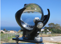
Campbell-Stokes |
Sunlight Hours Full name is Campbell-Stokes sunlight recorder |
|
|
|
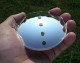
Mirror |
Cloud cover Oktas |
|
|
|
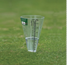
Rain gauge |
Precipitation Millimetres |
|
|
|
What are the 4 main Latitude Zones |
|
|
|
|
Name the characteristics of polar zones? |
|
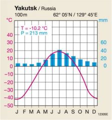
Arctic Hare
polar climate graph |
|
|
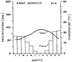
Name the characteristics of the Temperate zones? |
|
Temperate climate graph |
|
|
Name the characteristics of the Arid zones |
|
Fennec Fox
Mediterrane-an arid climate |
|
|
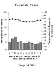
Name the characteristics of Humid zones |
|
Jaguar
Humid climate graph |
|
|
Factors affecting microclimates |
|
|
|
|
Shelter |
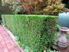
Can provide protection from the sun and wind
shade side would be cooler |
|
|
|
Surface |
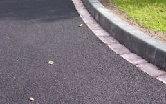
Darker surfaces absorb more heat than light surfaces. Tarmac would be hotter than snow |
Think of the Albedo effect |
|
|
Aspect |
The South is always warmer than the North
|
Why do people insist on their vineyards facings outwards? |
|
|
Natural and Physical features |
|
|
|
|
Buildings |
|
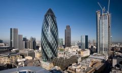
Why is London warmer than Hertfordshire which is only an hour's drive away? |
|
|
What is the definition of Urban heat island? |
A metropolitan area that is warmer than rural areas due to human activity. |
|
|
|
What are the causes of Urban heat island? |
|
|
|
|
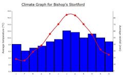
What do climate graphs show |
How temperature and precipitation vary throughout the year for a particular area |
|
|
|
Describe how to interpret climate graphs |
|
|
|
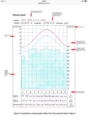
Describe this climate graph |
|
|
|
|
What are Air Masses |
Large bodies of air sharing common temperature and humidity characteristics |
|
|
|
UK Air Masses situation |
|
|
|
|
Thank You |
Thank You |
|