Reading...
![]()
Play button
![]()
Play button
![]()
Use LEFT and RIGHT arrow keys to navigate between flashcards;
Use UP and DOWN arrow keys to flip the card;
H to show hint;
A reads text to speech;
19 Cards in this Set
- Front
- Back
|
First of all, what are cyclones?
|
1.) Area of of low pressure and rotating winds
-norther hemisphere is counter-clockwise -southern hemisphere is clockwise 2.) Tropical and Extratropical? Based on origin and core temperature 3.) Characterized by intensity |
|
|
Tropical Cyclones
|
1.) Form over tropical ocean water (5-20 degrees)
2.) Have warm cores 3.) Hurricanes, high winds, heavy rain, surges, tornadoes 4.) Gets energy from warm ocean air and latent heat |
|
|
Extratropical Cyclones
|
1.) Form over land or water in temperate regions (30-70 degrees)
2.) Have cool cores 3.) Strong windstorms (Polar jet stream and subtropical jet stream), rains, surges, snowstorms, blizzards 4.) Most are not very severe 5.) Derive energy from temperature contrasts along fronts |
|
|
Nor'easter
|
Extratropical!
Moves northward along US East coast |
|
|
Hurricanes
|
Tropical!
-In Atlantic or Eastern Pacific Oceans -Are classified at speeds of 74 mph -Thick layer of warm ocean water that is deep -Steep vertical temperature gradient (atmosphere cools quickly when you increase altitude) -Weak vertical wind shear |
|
|
Typhoons
|
Tropical!
In Pacific Ocean -West of International Date Line -North of Equator |
|
|
Cyclone (cyclone) Ya na'mean?
|
Tropical!
In Indian Ocean |
|
|
What is the Saffir-Simpson Scale?
|
Classifies hurricanes by windspeed
1= winds 74-95 mph (Katrina and Irene) 5= winds 155 mph |
|
|
How to name a storm?
|
Sometimes named after their origins
Needs to be approved by World Meteorological Organization -named when winds=39 mph -male/female names alternated -reused every 6 years -big storm names retired -names are assigned sequentially each year from list for each origin |
|
|
What's a Tropical Disturbance?
|
1.) Mass of thunderstorms lasting for >24 hrs
2.) Typically spans the width of 120 -370 mi 3.) Weak rotation cuz of Coriolis effect 4.) Ways they are formed: -lines of convection -Upper-level low pressure troughs -Remnants of cold front -Easterly waves of converging and diverging winds (like atlantic ocean hurricanes) |
|
|
Tropical Depression
|
When tropical disturbance wind speeds begin to increase and spin
-forms a low pressure center |
|
|
Tropical STORM
|
-Winds increase to 39 mph
-Storm is given a name -Rainfall is intense but wind speeds are not like a hurricane |
|
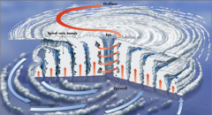
Structure of Hurricanes
|

Includes Rain Bands, Eyewall, and Eye
*see other notecard for descriptions Warm, moist air spirals upward along EYEWALL (loses moisture as it rises) which causes dry air to sink back into center and air to flow out of the top (pic) |
|
|
Rain Bands in terms of a hurricane?
|
Clouds that spiral inward around center (counterclockwise in northern hemisphere)
*They get more intense towards the center of the hurricane |
|
|
Eyewall
|
Innermost band of clouds which contain the greatest WINDS and RAINFALL
|
|
|
Eye
|
Center of calm!
Narrow at surface, wider at top |
|
|
Paths of Hurricanes
|
Controlled by Coriolis Effect
-Northern Hemisphere to right -Can make a loop -North atlantic, they are steered by Bermuda High As it moves over land it loses energy because there isn't enough warm water (can become extratropical cyclone) |
|
|
Polar Jet Stream
|
-Crosses US in winter and canada in summer
-High pressure ridges and low pressure troughs cause jet streams to bend (waves/meanders) - ...... |
|
|
Subtropical Jet Stream
|
-Crosses Mexico and Florida, strongest in winter
|