![]()
![]()
![]()
Use LEFT and RIGHT arrow keys to navigate between flashcards;
Use UP and DOWN arrow keys to flip the card;
H to show hint;
A reads text to speech;
45 Cards in this Set
- Front
- Back
|
Oceanography |
Study of the ocean |
|
|
How do oceans regulate climate? |
By transferring heat and distributing water across the globe. Its coastal processes shape the land |
|
|
How much of Earth's mass does the total volume of water take up? |
.023% of Earth's mass |
|
|
Why do oceans exist? |
Density differences in the crust Oceanic crust forms at spreading centers and "floats deeper" (because it's denser) on the mantle, creating basins that fill with water. |
|
|
Bathymetry |
The study of the varied topography of the seafloor. In general, it deepens away from the continents |
|
|
Shelf |
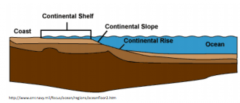
Gently sloping part of the continent under shallow water (>= 500 m) Forms as a result of a series of normal faults that cause the continental slope to bend Underlain by thinned continental crust |
|
|
Continental rise |

Transition zone b/n the slope and the abyssal plain Transitional zone b/n crust types |
|
|
Continental slope |
Descends to ~4km at ~2 degrees Transitional zone b/n crust types |
|
|
Abyssal plain |
Seafloor
|
|
|
Submarine canyon |
Cuts between the continental shelf. Formed by large streams at times of low se level Carries terrestrial sediments to deeper water. Alluvial fans grow where they empty onto the rise |
|
|
Continental margin |
Zone consisting of the shelf, slope, and rise |
|
|
Difference b/n the two types of continental margins |
While active margins occur at subduction zones, passive margins develop as continents move away from a spreading center; thick sediment develop there. |
|
|
How does seafloor topography reflect plate tectonics? |
Mid-ocean ridges => divergent plate boundaries Transform faults => strike-slip boundaries Ocean trenches => convergent boundaries |
|
|
Why do mid-ocean ridges rise up as mountains? |
They are warm and less dense due to the formation of new rock |
|
|
What creates sea mounts and what happens to them over time? |
Hot spots build sea mounts that may reach the surface. Over time the volcano moves off the hot spot and gets eroded to sea level. Continued erosion produces a flat-topped guyot |
|
|
How does plate tectonics shape a region's coastline |
Passive margins => low-lying coastal plains |
|
|
Describe emergent coasts and where they form |
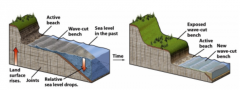
Characterized by stream incision, wave-cut benches, platforms, and terraces Develop where there is a relative sea level drop, either due to continental uplift or actual sea level drop |
|
|
Describe submergent coasts and where they form |
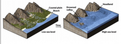
Characterized by flooded glacial or stream valleys that create estuaries or fjords Develop where there is a relative sea level rise, either due to land subsidence or actual sea level rise |
|
|
Estuaries |
River valleys flooded w/ seawater. Characterized by brackish water and organisms adapted to such water. Formed when streams cut valleys during glaciation; glacial retreat raised sea level and drowned the valleys |
|
|
Fjords |
Similar to estuaries, but were carved by glaciers. Form U-shaped troughs out of rock |
|
|
Describe the east coast of North America during the Ice age relative to today |
During the Ice Age, the coast was an emergent coast when so much water was stored in glaciers that sea level dropped 300 ft. Today, it's a submergent coastline |
|
|
Why is sea water salty |
Salts from chemically weathered rocks and carried by streams is dissolved in water |
|
|
How is salinity affected by climate? |
Saltier water occurs in areas of high evaporation & in cold areas where ice forms Less salty water occurs in regions w/ high rain or river input |
|
|
Relationship b/n surface temp & latitude |
Inverse relationship |
|
|
How does the ocean moderate climate? |
It acts as buffer b/n wide temperature shifts |
|
|
Ocean currents and what they are driven by |
Constantly move water around the globe. Driven by wind shear Spiraled into large gyres by the Coriolis deflection |
|
|
Describe the two types of winds and describe how they drive vertical currents |
Offshore winds pull water away and cold, nutrient-rich water rises to replace it. Called upwelling Onshore winds pile warm water on coasts, where they are driven down to deep water. Called downwelling |
|
|
Other than wind, what else drives vertical currents? |
Temperature and salinity contrasts. Cold and saline waters are dense, so polar water sinks to the bottom to replenish deep water Sinking polar water is replaced by surface flow from the tropics, which carries warm water to polar regions. |
|
|
Intertidal zone |
Region b/n high and low tide lines |
|
|
What causes tides? |
Gravitational tugging of the sun (weaker) and moon (greater). Their tidal effects interaact to make heightened "spring" tides and dampened "neap" tides |
|
|
What creates waves |
Generates friction of air and water. Gentle breezes create small waves, while gales create large waves. Height, length, and period depend on wind speed, wind direction, and distance of travel (fetch). |
|
|
Crest |
Top of the wave |
|
|
Trough |
Low b/n crests |
|
|
Wavelength |
Distance b/n crests |
|
|
Wave base |
1/2 wavelength Depth of wave influence Above wave base, molecules move in circular motion. Below, they don't move. |
|
|
What happens when waves hit the shore? |
Their base hits bottom. Friction slows it while the top continues moving fast. The wave becomes a breaker and crashes on the beach |
|
|
Why are Ireland and England warmer than North America? |
Warm surface currents flow to Western Europe, while cold water lies on the eastern seaboard |
|
|
What happens when waves hit an irregular shoreline? |
Waves bend around objects jutting into the water (refraction). Wave energy is concentrated on the objects and dissipated in the embayments. Over time, this process tends to straighten shorelines |
|
|
Final Question: How do longshore currents develop and what do they carry |
Develop when waves hit shore at an angle. Waves push sediment up and sideways along the beach, while gravity pulls it back down. These currents move sediment and near-shore objects down the beach |
|
|
What causes beach drift |
Caused by long-shore currents and moves large amounts of sand. Responsible for large sandbars and spits |
|
|
What causes rip currents? |
Develop when waves hit the shore straight on. Waves pile water up on the shore and gravity pulls it back out. Current is perpendicular to the beach and dissipate away from the surf zone |
|
|
Where do beaches develop? |
Develop where there is abundant input of clastic sediment. Dominated by sand or gravel; mud is usually absent. Develop distinct profiles w/ a foreshore, beach face, and backshore |
|
|
How do seasons affect beaches? |
Beaches are broad in the summer, when calm waves pile sand on the shore They are narrow in the winter, when strong waves erode the beach. |
|
|
Where do coral reefs develop? How do they modify sediment deposition? |
Develop in tropical settings where animals make large structures form their carbonate skeletons. |
|
|
Atolls |
Reefs formed on a subsiding volcano. Forms when volcano is active. After extinction, the volcano erodes and subsides. Reef keep paces w/ subsidence, eventually producing a ring-shaped structure surrounding a lagoon |