![]()
![]()
![]()
Use LEFT and RIGHT arrow keys to navigate between flashcards;
Use UP and DOWN arrow keys to flip the card;
H to show hint;
A reads text to speech;
38 Cards in this Set
- Front
- Back
|
the study of Earth and its people |
geography |
|
|
a 3-D model of the Earth |
globe |
|
|
a flat drawing that shows how something looks from above |
map |
|
|
shows you how to read a map; also called a legend |
map key |
|
|
pictures or drawings that stand for things that are real |
symbols |
|
|
a symbol on a map that shows directions |
compass rose |
|
|
the 4 main directions: north, south, east, and west |
cardinal directions |
|
|
directions that come between the main ones: northwest, southwest, northeast, southeast |
intermediate directions |
|
|
a make-believe or imaginary line that divides the Earth in half |
Equator |
|
|
one of the halves into which the Earth is divided |
hemisphere |
|
|
eastern part of the Earth; includes Asia, Africa, Australia, and Europe |
Eastern Hemisphere |
|
|
western part of the Earth; includes North and South America |
Western Hemisphere |
|
|
the half of the Earth between teh South Pole and the Equator |
Southern Hemisphere |
|
|
the half of the earth between the North Pole and the Equator |
Northern Hemisphere |
|
|
divides the Earth into the Eastern and Western Hemispheres |
Prime Meridian |
|
|
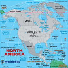
one of the largest bodies of land on the Earth |
continent |
|
|
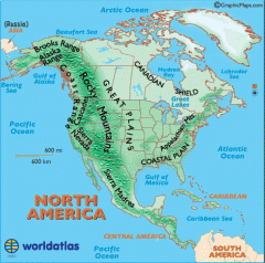
a map that shows Earth's surface features (oceans, mountain, rivers, etc.) |
physical map |
|
|
a map that shows governing divisions (countries, cities, state, etc.) |
political map |
|
|
a map that shows a view from space |
satellite map |
|
|
imaginary lines on a globe that show the distance from the Equator |
latitude |
|
|
imaginary lines on a globe that show the distance from the Prime Meridian |
longitude |
|
|
northern most point on the Earth |
North Pole |
|
|
southern most point on the Earth |
South Pole |
|
|
runs east and west |
lines of latitude |
|
|
runs north and south |
lines of longitude |
|
|
a line of longitude that runs through Greenwich, England |
Prime Meridian |
|
|
north, south, east, west |
Cardinal Directions |
|
|
northwest, northeast, southwest, southeast |
Intermediate Directions |
|
|
divides the Earth into the Western and Eastern Hemispheres |
Prime Meridian |
|
shows governing divisions (countries, cities, states, etc.) |
political map |
|
shows Earth's surface features (oceans, mountains, rivers, etc.) |
physical map |
|
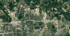
shows view from space |
satellite map |
|
|
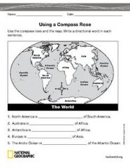
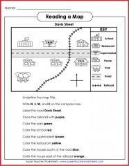
Be able to use a compass rose to locate things on a map (see the sample worksheet) |
|
|
|
Be able to read a map key or map legend (see the sample worksheet) |
|
|
|
Be able to locate things on a map (see the sample worksheet) |
|
|
|
Be able to order the world we live in by size Think: Please Have Caring Concern to See Citizens Happy |
Planet, Hemisphere, Continent, Country, State, City, Home (Address) |
|
|
Know your place in the order of the world we live in by size |
Example for Forest Avenue: Planet-Earth Hemisphere- Northern Hemisphere Continent-North America Country-USA State-Alabama City-Montgomery Home- 1700 W. Fifth St. Montgomery, AL 36106 |
|
|
Know how to find capitals on a map |
***Look for the city with the STAR on it. |