![]()
![]()
![]()
Use LEFT and RIGHT arrow keys to navigate between flashcards;
Use UP and DOWN arrow keys to flip the card;
H to show hint;
A reads text to speech;
50 Cards in this Set
- Front
- Back
|
What is a glacier, what is it's relative earth coverage, and which glacier caused the erosional and depositional landforms across the northern hemisphere? |
A glacier is a mass of ice onland consisting of compactedand recrystallized snow thatflows under its own weight. The sea ice of the Arctic Ocean,ice shelves adjacent toAntarctica, and icebergs are notglaciers. Glaciers cover 1/10 of Earth’sland surface The vast glaciers of thePleistocene (1.6 million to10,000 years before present) IceAge produced many erosionaland depositional landformsacross much of the NorthernHemisphere. |
|
|
What are some of the largest glaciers in the world and their volumes? what is the approximate global volume? |
LOCATION AREA COVERED (km 3) Antarctica 12,653,000 Greenland 1,802,600 Northeast Canada 153,200 Central Asian ranges 124,500 Spitsbergen 58,000 Other Arctic Islands 54,000 Alaska 51,500 South American ranges 25,000 West Canadian ranges 24,900 Iceland 11,800 Scandinavia 5,000 Alps 3,600 Caucasus 2,000 New Zealand 1,000 Others 1,450 Total14,971,550 km3 |
|
|
Why do we study glaciers? |
Understanding the cool global climates thataccompanied widespread past episodes of glaciationmay clarify some aspects of long-term climate change,which bears on the debate over anthropogenic (chiefly of environmental pollution and pollutants) globalwarming. Present day glaciers are sensitive to short-term climatevariations and are monitored to help track climatictrends. Glaciers are dynamic and thus an opportunity to studythe interactions among Earth’s major systems. Glacial ice is the largest reservoir of freshwater. Itcontains over 75% of all of Earth’s freshwater. Some of the most spectacular scenery in our nationalparks was formed by the action of glaciers. |
|
|
Explain Glaciers and the hydrologic cycle |
Glaciers are one of the several reservoirs of thehydrosphere. Glacial ice is formed of the snow that falls over land. Freshwater may be stored in glaciers as ice for thousandsof years before it is eventually returned to the sea, oftenpassing through other reservoirs on its journey. In the Western U.S. andCanada, glaciers helpsupply streams withwater during the dryseason. |
|
|
What percentage of earth is covered in ice now and in the Pleistocene period? |
10% of the earth is covered by glaciers, howeverthis is much less than during the Pleistocene whenup to 30% was covered by ice As discussed earlier 97% of the earth’s water is inthe oceans, 75% of the remainder is trapped inglaciers. Consequently they represent aconsiderable fresh water resource. In Alpine countries such as Switzerland meltwaterfrom glaciers comprise the principal source ofdomestic water. Glaciers in Scandinavia, Alaska, Alberta and B.C.supply a natural baseflow of water to rivers helpingto offset times of drought |
|
|
What is the origin of glaciers (how are they created)? |
Glaciers form in areaswhere snow fallexceeds snow melt fora number of years (highaltitudes and latitudes) As the snowpackthickens the air isforced out of the snowat the base of the pile.Eventually blue ice willform |
|
|
How does a glacier behave once it's 30m high? |
Once the snow pack reached ~30m it will begin tobehave as a viscous fluid and “flow” downhill. Thisplastic flow is restricted to the base of the glacier whilethe upper layers remain brittle! Glaciers ablate (Ablation is removal of material from the surface of an object by vaporization, chipping, or other erosive processes),or waste away bymelting or calving. |
|
|
What is Ice calving as it pertains to glaciers? |
Ice calving, also known as glacier calving oriceberg calving, is the breaking off of chunks of ice at the edge of a glacier |
|
|
What is the "zone ablation" and the "position terminus" for glaciers? |
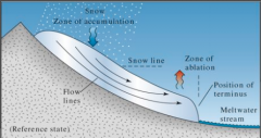
Glaciers move at rates of a few metres to 10s ofmetres per day depending on the slope,however they also retreat or advance within thevalley |
|
|
What is the rate of glacier advance? |
If the rate of melting is less than the rate of glacieradvance then the glacier will advance, if it is not then theglacier will retreat. Glaciers typically retreat in thesummer and advance in the winter. Global climatechange can modify this process |
|
|
How do glaciers move? |
When snow and ice reach acritical thickness of about40m, the stress/pressure onthe ice at depth is greatenough to induce plasticflow. Plastic flow is a typeof permanent deformationthat involves no fracturing.As the ice deforms byplastic flow, the glacierslowly moves. |
|
|
What is Basal Slip? |
Glaciers also slidealong the surface ofthe material theyoverlie in a processcalled basal slip, whichis greatly aided by thelubricating effect ofwater. Basal slip issporadic and variesdepending on season,but plastic flow iscontinuous and theprimary means bywhich glaciers move. |
|
|
How fast do glaciers move? h |
Valley glaciers flow more rapidly thancontinental glaciers, both ranging fromcms to 10s of meters/day. Valley glaciers move faster because basalslip contributes to their movement duringthe warm season. Continental glaciersare frozen to the underlying surface mostof the time and undergo little basal slip. Flow rate within ice increases down theglacier toward the firm limit (Firn is partially compacted névé, a type of snow that has been left over from past seasons and has been recrystallized into a substance denser than névé ), and thendecreases from the firn limit toward theterminus. For valley glaciers, flowvelocity is greatest at the top-center of theice tongue and lowest along the edgesand base where friction retards flow. |
|
|
What is a valley glacier? |
Valley glaciers are tongues ofice confined to mountainvalleys through which theyflow from higher to lowerelevation. Like streams,many valley glaciers havesmaller tributary glaciers. Valley glaciers may beseveral kilometers wide, 200km long, and hundreds ofmeters thick. The BeringGlacier of Alaska is about200 km long, and theSaskatchewan Glacier inCanada is 555 m thick. |
|
|
What is a continental glacier? |
Continental glaciers, or ice sheets, cover at least 50,000 km2 andare unconfined by topography. Continental glaciers are blanket-likeaccumulations of snow and ice that drape the land surface andflow outward in all directions from a central area of greatestthickness toward thinner areas along the margins. Continental glaciers are currently found in Antarctica andGreenland wheretheir thicknessexceeds 3000 m.During the Ice Age,continental glacierscovered much ofNorth America andEurasia. |
|
|
Explain what happens with glacial erosion and transport? |
Glaciers are moving solids and can erode and transporthuge amounts of material, especially sediment, and soil. Bulldozing takes place as a glacier shoves or pushesunconsolidated material along its path. Plucking resultswhen glacial ice freezes in the crevices of a bedrockprojection and eventually pulls loose blocks of the rock.Abrasion takes place as bedrock underlying a glacier iseroded by the flowing sediment-laden ice. Most of the sediment carried by continental glaciers isconcentrated at the base of the ice and derived from thematerials across which they flow. Valley glaciers carrysediment in all parts of the ice. Much of their sediment issupplied by mass wasting along valley walls. |
|
|
What is rock flour? |
Abrasion of bedrock bysediment-laden glacial iceproduces glacial polish, asmooth surface that glistens inreflected light. Abrasion can also produceglacial striations, straightscratches a few mm deep onrock surfaces Abrasion grinds rocks to clay andsilt-size particles collectivelyknown as rock flour. Thismaterial gives glacial streams amilky look. |
|
|
Describe plucking and abrasion |

|
|
|
What is a horn, arete, cirque, trucated spur, and a hanging valley? |
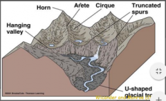
Some of the world’s most inspiring scenery waserosionally sculpted by valley glaciers. Whenpeaks and V-shaped stream-cut valleys ofmountain ranges are modified by valley glaciers, alandscape of angular ridges and peaks in the midstof a broad valley is forms. Among these featuresare horns, aretes, cirques, etc. |
|
|
What is a U Shaped valley? |
U-shaped glacial troughs areone of the most distinctivefeatures of valley glaciation.Glaciers deepen, widen, andstraighten V-shaped streamvalleys to form broad, steepsidedvalleys. Manyglacial troughs containtriangular-shaped truncatedspurs, cut off ridges thatextend into the originalvalley. Fiords A long, narrow, deep inlet from the sea between steep slopes of a mountainous coast. Fjords usually occur where ocean water flows into valleys formed near the coast by glaciers. |
|
|
What are hanging valleys? |
Hanging valleys are glaciated tributary valleys whosefloors are higher than that of the main valley. Largeglaciers in the main valley erode more vigorously thansmaller glaciers in tributary valleys. When the glaciersdisappear, the floors of tributary valleys are left high abovethe floor of the main valley. Streams flowing from thesehanging valleysproduce beautiful waterfalls, such as Bridal VeilFalls in Yosemite NationalPark, California. |
|
|
What is a Cirque? |
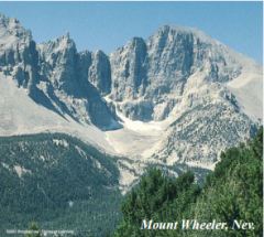
Cirques are bowl-shapeddepressions at the headsof glacial troughs. Cirques are steep-walledon three sides, but oneside is open and leads tothe glacial trough. Many cirques containsmall lakes known astarns. |
|
|
What is the difference between an Arete & a Horn? |
Aretes are narrow,serrated, knife-edgeridges forming a thinpartition between twocirques or adjacentparallel glacial troughs Horns are pyramidal,steep-walled mountainpeaks formed byhead ward erosion ofcirques. To form, a hornmust have at least threecirques on its flanks |
|
|
what is glacial quarrying? |
Plucking, also referred to as quarrying, is a glacial phenomenon that is responsible for the erosion and transportation of bedrock, especially large "joint blocks" |
|
|
Describe how erosion by continental glaciers works. |
Erosion by continental glaciers produces smooth and roundedlandscapes. High areas that project into the ice are beveled andabraded to form a relatively flat topography interrupted by roundedhills. Ice-scoured plains characterized by deranged drainage withnumerous lakes and swamps, extensive bedrock exposures, and littleor no soil are an example of erosion by continental glaciers. |
|
|
what is an example of a glacial deposit? |
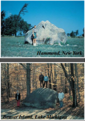
Both valley and continentalglaciers deposit their sedimentload as glacial drift, a general termfor glacially deposited material. Avast sheet of glacial drift of thePleistocene Epoch blankets thenorthern U.S. and adjacentCanada. Erratics are boulders eroded andtransported by glaciers anddeposited in areas from which theywere obviously not derived. Till ispoorly sorted sediment depositedby glacial ice. Stratified drift islayered, sorted sediment depositedby flowing meltwater |
|
|
How is a moraine composed? |
Moraines are piles ofpoorly sortedsediment, till,delivered by flowingice to the terminus ofa stationary glacier.They are deposited byboth valley andcontinental glaciers. As the sediment isdumped, an endmoraine builds up toform crescent-shapedhills fringing the icemargin. |
|
|
What is a recessional moraine? |
The outermost end moraines deposited when the glacier was at itgreatest extent are called terminal moraines. If the glacier recedes andeventually stabilizes at a new location, an end moraine known as arecessional moraine accumulates at the terminus. Ground moraines aredeposited as glaciers recede and sediment is liberated form the meltingice. Ground moraines have an irregular, rolling topography. |
|
|
Explain the deposition of moraines |

|
|
|
What is the difference between a medial moraine and a lateral moraine? |
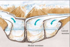
Lateral and medial moraines are produced by valley glaciers. Lateral moraines are long ridges of till deposited along the edges of the glacierMedial moraines occupy positions that were near the center of the valley glacier. Medial moraines form by the coalescence of the lateral moraines of two tributary glaciers |
|
|
What is a Drumlin? |
Drumlins are elongated hills composed of till and shaped like aninverted spoon. Some are 50 m high and 1 km long, but most are smaller. Drumlins occur in drumlin fields containing hundreds orthousands of drumlins. Drumlins are depositional landforms constructed by continentalglaciers. |
|
|
What is a stratified drift? |
Stratified drift is deposited by both valley and continentalglaciers, but is more extensive in areas of continentalglaciation. Outwash plains, kames, eskers, and kettle lakes are somecommon landforms formed of or in stratified drift. |
|
|
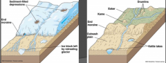
How are landforms composed of drift? |
Outwash plains are vast blankets ofstratified drift deposited by braided glacialmeltwater streams in front of the terminusof continental glaciers. Blocks of ice stranded by receding glaciersare buried by sediments of outwash plainsand valley trains. Circular to ovaldepressions formed when the ice blocksmelt are kettles. Kettle lakes result whenthese depressions fill with water. Someoutwash plains have so many kettles theyare called pitted outwash plains. |
|
|
What is a Kame? |
Kames are conical hills upto 50 m high composed ofstratified drift (left). Manyform when streams depositsediment in a depressionon a glacier’s surface; asthe ice melts, the deposit islowered to the groundsurface. |
|
|
What is an esker? |
Eskers are low, sinuous ridges of stratified driftdeposited by streams flowing in tunnels beneathstagnant ice. They range to 100 m in height and100 km in length. |
|
|
What is a proglacial Lake? |
Proglacial lakes formed bymeltwater accumulation alongthe margins of glaciers suchthat one shoreline was glacialice. Varves are proglacial lakedeposits consisting ofalternating laminations of lightand dark fine-grainedsediment. Each light-darkcouplet represents one annualcycle of deposition. Lightlayers formed during springand summer and consist ofsilt, whereas dark layersformed during the winter andconsist of clay. |
|
|
What are some of theEffects of Glaciation? |
The Pleistocene glaciations have had a significantimpact on modern society Soil distribution Groundwater distribution Sea level changes Pleistocene lakes Isostatic rebound Drainage patterns |
|
|
Where do some of the best agricultural soils lie? |
Soil distribution - Some of the best agricultural soils lie on sedimentsdeposited in glacial lakes and on glacio-eolian deposits(loess) |
|
|
What were some of the effects of glaciation from 18,000 years ago? |
Sea level changes The growth of the ice sheets resulted in sealevel drops of about 100m, while the melting ofthe existing polar ice caps would raise sealevels by ~40m |
|
|
What is glacial outwash? |
Groundwater distribution Glacial outwash is the sediment deposited byrivers originating at the melting edge of a glacier.Many of these glacial outwash deposits nowserve as important groundwater aquifers. |
|
|
What is Isostatic rebound? |
Isostatic rebound The ~2km thick ice caps of the Pleistocenewere so massive that they depressed thecrust on which they formed. Since the end ofthe ice age the land exposed by the retreatof the ice sheets has been rising in aprocess called isostatic rebound. The rate ofuplift is ~ 6mm per year with measureduplifts of up to 275m |
|
|
What are some of the affects of dried up Pleistocene lakes? |
Pleistocene Lakes The retreating ice sheets left numerous glaciallakes across N. America, the majority of whichhave now dried up (Lake Bonneville). Many ofthese lakes charged the neighbouring aquiferswhile others provided rich soils. Lake Agassiz, centered on present dayManitoba, was the largest known NorthAmerican lake with an area twice that of thegreat lakes combined. Much of the rich prairiesoils in Manitoba were deposited in LakeAgassiz |
|
|
What causes an ice age? |
Five periods of glaciation (Ice Ages) separated by longerperiods of mild climate are recognized in the geologic record.Such long-term climate changes probably resulted fromchanges in atmospheric and oceanic circulation patterns aswell as changes in the geographic position of continents,both driven by plate tectonics. During the Pleistocene Ice Age, several periods ofcontinental glaciation are recognized, each separated by awarmer interglacial period. These intermediate-term climatechanges spanned tens to hundreds of thousands of yearsand may be explained by the Milankovitch Theory. Climatic events like the Little Ice Age take place on a scale ofcenturies and are considered short-term. Hypothesesfavoring variations in solar energy and volcanism have beenproposed. |
|
|
Explain The Milankovitch Theory |
The theory draws on minor irregularities in the Earth’s orbit androtation to explain intermediate-term climate changes and thus thetiming of glacial advances and contractions during ice ages.These orbital androtationalirregularitiescollectively cause theamount of solar heatreceived at any latitudeto vary over time,perhaps triggeringonset of glacial interglacialepisodes. |
|
|
ExplainThe Milankovitch Theory as it pertains to orbital eccentricity. |
! Orbital eccentricity refers to the degree to which Earth’ssolar orbit departs from a perfect circle. Earth’s orbitreaches maximum eccentricity every 100,000 years. Thiscorresponds closely to the 20 warm-cold cycles thatoccurred in the Pleistocene |
|
|
Explain the The Milankovitch Theory as it pertains to wobble. |
The inclination of Earth’s rotational axis shiftsabout 1.5° on a 41,000 year cycle causing arotational wobble. |
|
|
Explain the The Milankovitch Theory as it pertains to precession. |
Precession concerns the effect resulting from movement of Earth’srotational axis as it traces out the path of a cone in space. Thiscycle spans 23,000 years and affects Earth’s proximity to the Sunin summer and winter |
|
|
What is the cyclic patter of the ice ages? |
The cyclic pattern of the ice ages can be related to minorchanges in the earth’s rotation. Three factors influence theonset of ice ages 1. Obliquity of the earth’s axis 2. Eccentricity of the earth’s orbit 3. The precession of the earth’s axis Each factor alone can cause a “little ice age” (1450-1850)when they act in concert a major glaciation can occur.However, the expected temperature changes from theseevents cannot account for the 4° to 10° drop seen in thePleistocene There is geological evidence for 20 or more periods of deepcooling in the Pleistocene with intervening warm periods |
|
|
What is some of the evidence of global climate change? |
Evidence for global climate change comes from avariety of sources, including: Glaciers – many N. American glaciers have stoppedadvancing or ceases to exist Oxygen isotopes Surface temperatures Forams Tree rings |
|
|
What are some secondary factors for global climate change? |
Other possible factors include 1. Volcanic activity 2. Increased atmospheric dust 3. Changing ocean currents |