![]()
![]()
![]()
Use LEFT and RIGHT arrow keys to navigate between flashcards;
Use UP and DOWN arrow keys to flip the card;
H to show hint;
A reads text to speech;
51 Cards in this Set
- Front
- Back
- 3rd side (hint)
|
GIS |
geogtaphic Information systems |
|
|
|
Geography deff |
all aspects of what happens on earths surface natural and non |
|
|
|
4 major parts of geography |
spatial tradition human-land tradition area studies tradition earth science tradition |
shae |
|
|
systems def |
a set lf interrelated or interconnected parts tjat form an integrated unit. a systwm as a whole is greater than its parts |
|
|
|
GIS deff |
a computer based technology and methodology for collecting, managing, analyzing, modeling and prescribing geographic data for a wide range of application |
|
|
|
5 major components of gis |
hardware software data methods people |
|
|
|
geodatabase deff |
a barell of data tapology within data |
|
|
|
ENIAC |
electronic numerical integrator and calculator |
|
|
|
what typified each of the 4 generations of computers |
vacuum tubes transistors circuts microchips |
|
|
|
dbms |
database management system |
|
|
|
esri |
environmental systems research institute |
|
|
|
mge |
modular gos environment by intergraph |
|
|
|
nsdi |
national spatial data infrastructure |
|
|
|
nii |
national information infrastructureat |
|
|
|
gui |
geographic user interface |
|
|
|
lunr |
land use and natural resources inventpry |
|
|
|
tiger |
topological integrated geographic encoding and referencing |
|
|
|
dime |
dual independent map encoding |
|
|
|
gimms |
geographic imformation mapping and management system |
|
|
|
topology deff |
thw spatial relationship of features |
|
|
|
pc |
peraonal computer |
|
|
|
ascii |
american standard code for information interchange |
|
|
|
nad |
th american datum |
|
|
|
gcs |
geographic coordinate system. used 3d spherical serface to depict earth. measured in dd. unprojected |
|
|
|
a properr map needs... |
date orientation geographical indicator scale legend author neatline title
|
dog sled |
|
|
who is kbow as inventor of geography |
erasrothenes. he created first world map with grid system 276-194 bc |
|
|
|
2 types of maps |
general purpose maps themed maps (tax recorda, soil type) |
|
|
|
waldo tobler |
had idea of putting maps into computer |
|
|
|
mimo |
map in map out |
|
|
|
ian mcharg |
proposed overlay method |
|
|
|
roger tomlinson |
father of gis |
|
|
|
cgis |
canadian geographic information syatem |
|
|
|
jack dangermond |
created esri in 1982 |
|
|
|
bayheim |
first globe in 1941 |
|
|
|
geoid |
shape of earth. we need a datum to help define the geoid |
|
|
|
datum |
multiple datapoints in one location |
|
|
|
cartograms |
maps that show info but distort size |
|
|
|
levels of measurement |
nominal cody savanah ordinal 1st 2nd 3rd interval elevation celcius ferenheight ratio kelvin population |
|
|
|
spcs |
tatw pla e coordinate system |
|
|
|
types of projections |
cylingrical conic azimuthal |
|
|
|
standard deviation advantage |
points out outliers |
|
|
|
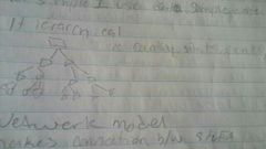
hierarchical dbms |
|
|
|
|
long vs flat |
long uses integers flat uses integers and decimals |
|
|
|
deff query |
allows you to only work with data you need |
|
|
|
sql |
standard query language |
|
|
|
cm-in |
2.5cm-1in |
|
|
|
km to m |
1.609km=1mile |
|
|
|
cm to m |
100cm-1m |
|
|
|
m to km |
1000m-1km |
|
|
|
relate tables when have |
many to 1, manu to many |
|
|
|
join tables when |
1 to 1, 1 to many |
|