![]()
![]()
![]()
Use LEFT and RIGHT arrow keys to navigate between flashcards;
Use UP and DOWN arrow keys to flip the card;
H to show hint;
A reads text to speech;
84 Cards in this Set
- Front
- Back
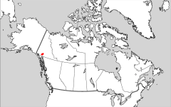
-Provincial and Territorial Capital |
Whitehorse |
|
-Provincial and Territorial Capital |
Yellowknife |
|
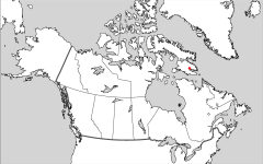
-Provincial and Territorial Capital |
Iqaluit |
|
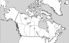
-Provincial and Territorial Capital |
Victoria |
|
-Provincial and Territorial Capital |
Edmonton |
|
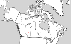
-Provincial and Territorial Capital |
Regina |
|
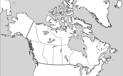
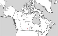
-Provincial and Territorial Capital |
Winnipeg |
|
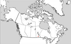
-Provincial and Territorial Capital |
Toronto |
|
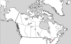
-Provincial and Territorial Capital |
Quebec |
|
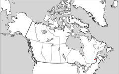
-Provincial and Territorial Capital |
St. Johns |
|
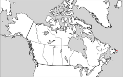
-Provincial and Territorial Capital |
Charlottetown |
|
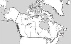
-Provincial and Territorial Capital |
Halifax |
|

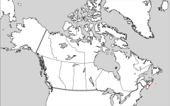
-Provincial and Territorial Capital |
Fredericton |
|
-National Capital |
Ottawa |
|
|
Geography-Define |
the study of the Earth's physical and human systems and the relationship between them |
|
|
Population density-Define |
a figure calculated by dividing the population of a region by the region's area |
|
|
Geographical systems-Define |
various interconnected systems that shape our world |
|
|
Global connections-Define |
economic, social, political and geographic connections between countries around the world |
|
|
Geo technologies-Define |
new geographic technologies such as remote sensing, GPS etc., that have revolutionized geography |
|
|
Gross Domestic Product-Define |
the total value of goods and services produced within a county per person excluding transactions with other countries |
|
|
Human Development Index-Define |
an index that includes measures of health, education and wealth to indicate a county's level of human developement |
|
|
Gender Empowerment Measure-Define |
an index designed to indicate the amount of economic and political power that a country's women have |
|
|
Environmental Sustainability Index-Define |
a measurement devised by the World Economic forum of current and future levels of environmental sustainability in 146 countires |
|
|
Human features-Define |
anything that is created by humans and is not natural |
|
|
Natural features |
anything that is natural and was not created by humans |
|
|
Map-Define |
a representation of the Earth's features drawn on a flat surface |
|
|
Scale-Define |
a measurement on a map that represents an actual distance on Earth's surface |
|
|
Small scale map-Define |
a map that shows a small amount of detail of a large area (1:250,000)
|
|
|
Large scale map-Define |
a map that shows a large amount of detail of a small area (1:50,000) |
|
|
General purpose map-Define |
a map that contains many different types of information |
|
|
Thematic map-Define |
a map containing information on only one topic or theme |
|
|
Topographic map-Define |
a large scale map showing both natural and human made features though symbols |
|
|
Digital mapping-Define |
when the location of geographic data is digitalized and placed in databases and used in various combinations to create maps |
|
|
Latitude-Purpose |
Measure distances North and South |
|
|
Latitude-Appearance |
Lines crossing a maps from East to West |
|
|
Latitude-Length |
Various lengths, longest as equator and shortest at the poles |
|
|
Latitude-Numbering |
From 0 at the equator and 90 at the poles |
|
|
Latitude-Special Lines |
Arctic Circle 66.5 N Tropic of Cancer 23.5 N Equator 0 Tropic of Capricorn 23.5 S Antarctic Circle 66.5 S |
|
|
Latitude-Hemispheres |
The equator divides South and North Hemispheres |
|
|
Latitude-Parallelism |
Yes, lines of latitude are parallel |
|
|
Longitude-Purpose |
Measures distances East and West |
|
|
Longitude-Appearance |
Lines crossing a map from North to South |
|
|
Longitude-Length |
All the same |
|
|
Longitude-Numbering |
From 0 at the Prime Meridian to 180 W/E |
|
|
Longitude-Special Lines |
Prime Meridian 0 International Date line 180 W/E |
|
|
Longitude-Hemispheres |
Prime Meridian divides East and West Hemispheres |
|
|
Longitude-Parallelism |
Meridians of longitude are not parallel and meet at the poles |
|
|
Canada's Area |
9,992,000 |
|
|
Canada's Population |
35,000,000 |
|
|
Canada's Population Density |
3.5/km2 |
|
|
Canada's Wealth/GDP |
$31,500 in US dollars |
|
|
Canada's life expectancy |
80 years |
|
|
What is a Mercator Projection Map? |
the shape is preserved but it distorts size (good for navigational purposes) |
|
|
What is a Equal Area Map Projection? |
it has the correct size of countries in relation to each other |
|
|
What is a Winkel Tripel Map? |
it still has distortions but has the best balance between size, shape distance and direction |
|
|
Latitude-Define |
the distance north or south of the equator measured in degress |
|
|
Longitude-Define |
the distance east and west of the prime meridian measured in degress |
|
|
Compass point-Define |
a direction on a compass, ie S and N |
|
|
Compass Rose-Define |
a diagram showing directions and bearings to indicate directions on maps |
|
|
Compass Bearing-Define |
degrees on a compass, measured in clockwise direction from 0 to 360 |
|
|
Alphanumeric grid-Define |
a grid that uses letters and numbers to identify squares of a grid pattern on a map |
|
|
Map Grid-Define |
a series of lines on a map that can be uses to locate any place on the map |
|
|
Easting-Define |
the first 3 figures in a map reference giving the E-W location |
|
|
Northing-Define |
the last 3 figures in a map reference giving the N-S location |
|
|
Prime Meridian-Define |
the line of longitude on maps/globes that joins the N and S poles and runs through Greenwich, England. |
|
|
Waypoint-Define |
a fixed location with coordinates that a GPS stores |
|
|
Telematics-Define |
GPS technology that is intergrated with computers and mobile communications equipment |
|
|
Geocaching-Define |
a hobby based on the use of a handheld GPS unit and maps to find a hidden cache |
|
|
Cardinal signs-Examples |
N,S,E,W |
|
|
Ordinal points-Examples |
NE, SW |
|
|
Intercardinal points-Examples |
NNE, WNW |
|
|
Direct statement scale-Define |
words that are used to describe the relationship between a distance on a map (1cm:10km) |
|
|
Line scale-Define |
a line divided into units of distance that represent the actual units on the ground |
|
|
Representative Fraction Scale-Define |
a scale on a map given as a ration of distance on the map to the distance on the ground |
|
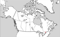
Name this water body |
Mackenzie R |
|

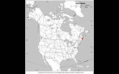
Name this water body |
St Lawrence R |
|
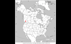
|
Fraser R |
|
|
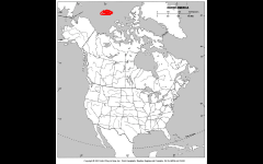
Arctic Ocean |
|
|
Atlantic Ocean |
|
|
Pacific Ocean |
|
|
Hudson's bay |
|
|
James bay |
|
|
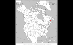
Bay of Fundy |
|
|
Gulf of St. Lawrence |