![]()
![]()
![]()
Use LEFT and RIGHT arrow keys to navigate between flashcards;
Use UP and DOWN arrow keys to flip the card;
H to show hint;
A reads text to speech;
35 Cards in this Set
- Front
- Back
- 3rd side (hint)
|
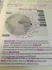
The global circulation model |
Back (Definition) |
|
|
|
The Hadley cell |
The pressure differences between the cells set up winds- predominantly from areas of high pressure to low pressure |
|
|
|
Ocean currents |
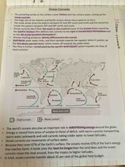
Temperature differences are caused by the Gulf Stream- this is one of several ocean currents. In the north atolanfic, cold salty water is heavy and sinks. This sets up a convection current which drags surface water down. The current draws warmer sultry water over the ocean surface from areas near the equator such as the Gulf of Mexico. This cools and sinks in the Labrador and Greenland seas, and flows south towards the equator, where it is warmer. |
|
|
|
What effect does a 1 degree increase in sea temp have? |
-Warmer summers -Milder winters -Rising air temp: melts poor ice + rising sea levels. Crops are lost due to heat (lowering food supply). -Sea temp rise: marine ecosystem change, sea ice melts (rising sea levels causing coastal flooding for low lying areas). -Extreme weather events are more frequent and severe. -Increasing temps allows disease to be spread more easily and move to different areas (malaria and are concerns for the future). |
|
|
|
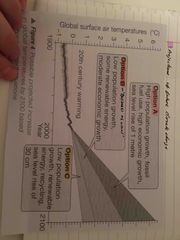
Timeline of the earth |
-Can study temp change fairly accurately over last 2.6 million years. -We have been able to more accurately record climate data since around 1870- this is done using weather instruments and keeping detailed written record over the years. -Prior to this we have only educated estimates using: fossilised animals, plants and pollens (shows where certain species lived to give an idea of climate conditions of regions. Landform evidence. Ice sheets and ice core records (ice sheets contain CO2 and deep layers can be thousands of years old). |
|
|
|
Types of evidence for climate change |
-Ice cores -tree rings -fossils -Historical sources. |
|
|
|
What are the natural causes of climate change? |
Eruption theory -If ash and gas rises from volcanoes enough, they spread around the earth in the stratosphere by high- level winds. Blanket of ash and gas stops some sunlight reaching earths surface. Instead sunlight is reflected off the ash and gas; backwards into space, which cools planet and lowers average temp. Orbital change -The earths orbit is sometimes circular and sometimes more elliptical. The earths axis tilts, sometimes mdr upright, and sometimes more on one side. The earths axis wobbles like a spinning top. These changes alter the amount of sunlight the earth receives. They also affect where sunlight falls on earth surface. On time scales of thousands of years, the changes would be enough to start two ice ages or end one. Changes are called the milankovitch cycle. |
|
|
|
What are the natural causes of climate change? |
Eruption theory -If ash and gas rises from volcanoes enough, they spread around the earth in the stratosphere by high- level winds. Blanket of ash and gas stops some sunlight reaching earths surface. Instead sunlight is reflected off the ash and gas; backwards into space, which cools planet and lowers average temp. Orbital change -The earths orbit is sometimes circular and sometimes more elliptical. The earths axis tilts, sometimes mdr upright, and sometimes more on one side. The earths axis wobbles like a spinning top. These changes alter the amount of sunlight the earth receives. They also affect where sunlight falls on earth surface. On time scales of thousands of years, the changes would be enough to start two ice ages or end one. Changes are called the milankovitch cycle. Variations in solar output. -sunspots: black areas in the suns surface. Loaf of spots means more solar energy being fired from the sun towards earths vice versa. The cycles of colmate change (in timescales of a few thousand hundred years) may be explained by sunspots. Asteroid collisions. -Big asteroids alter earths climate, need to be 1km diameter (which happens every 500,000 years). The impact blasts millions of tonnes of ash and dust into atmosphere. Dust and ash blocks sunlight. Similar to impact of a large volcanoes and its effect takes 5-10 years. |
|
|
|
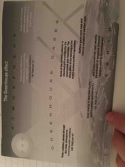
The greenhouse effect |
-A natural phenomenon that is vital for survival on earth -releasing green house gases accelerated the process- causes global warming |
|
|
|
What are the impacts of enhanced greenhouse effect |
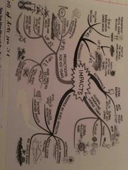
-Climate warms. -Ocean levels rise due to thermal expansion. -14 out of 20 warmest years have occurred since 1980. -90% of our valley glaciers are now shrinking. -Artic ice shrank by 3.2 million km2 in 27 years. -Sea level rise by lm by 2100. -Extreme events such as floods, droughts and heatwaves mote frequent. |
|
|
|
Future predictions for global warming |
-Scince 1980 global warming seems to have been happing rather quickly. -predictions aren’t to great either |
|
|
|
Stages of a tropical storm |
1) Warmer air currents rise from the ocean. As the warm air rises, more air rushes in to replace it; then it too rises, drawn by the fraught above. 2)Updraughts of air contain huge volumes of water vapour from the oceans, which condensed to produce cumulonimbus clouds. Condensation releases heat energy stored in water vapour, which Powers the storm more. 3) Coriolis force causes rising currents of air to spiral around the centre of the tropical cyclone, so it resembles a whirling cylinder. It rises and cools, and some of it descends to form the clear, cloudless, still, eye of the storm. 4) As the tropical storm tracks away from its source, it is fed new heat and moisture from the oceans, enlarging as it does so. 5) Once it reaches a landmass, it loses its energy source from the ocean. Air pressure rises as temperature falls winds drop, rainfall decreases, and it decays to become a mere storm. |
|
|
|
What are the 3 names for a tropical storm? |
Cyclone: Indian Ocean Typhoon: Pacific Ocean Hurricane: Atlantic Ocean |
|
|
|
What are the 3 conditions needed for a tropical storm? |
1) A large still want ocean (exceeds 26.5 C). Helps a want body of air to develop. 2) Strong winds in the troposphere. Draws up warm air rapidly from the earths surface. 3) A strong force created by the earth rotation- called the Coriolis force |
|
|
|
What is a track (of a tropical storm) and why do we study it? |
The track is the movement that a tropical storm takes. It follows a pathway driven by global wind. The track is studied so that people living in the pathway of the tropical storm can be warned, and evacuated if needed. |
|
|
|
What is a track (of a tropical storm) and why do we study it? |
The track is the movement that a tropical storm takes. It follows a pathway driven by global wind. The track is studied so that people living in the pathway of the tropical storm can be warned, and evacuated if needed. |
|
|
|
The structure of a tropical storm |
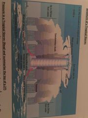
-Air pressure is the weight of air bearing down onto the earths surface. Is measured in millibars (163 mb is the average) -Tropical storms have a lower air pressure that the air surrounding them. The bigger the difference in pressure, the stronger the winds. The exception to air pressure is the eye in the centre. Is calm clear and descending dense air. |
|
|
|
What is a storm surge? |
When low air pressure causes sea levels to rise and high winds ouch the surge of the water towards land where it causes major coastal flooding. |
|
|
|
Case study for tropical storm: hurricane Katrina. |
What happened: began as low pressure system over Atlantic Ocean. Strengthen to form hurricane which approached he Florida coast on the 25/8/05. Reached category 5. Affected New Orleans and surrounding area. Sustained winds of 175 miles per hour. SOCIAL IMPACTS: 1800+ lost lives. People trapped in houses and roofs. Illness was common. Many left homeless as 800,000+ housing units were destroyed. Shortage of food and water. Looting was common. ECONOMIC IMPACTS: Damage cost and estimated $81 billion+. Oil facilities were damaged and as a result petrol prices rose in UK and USA. ENVIRONMENTAL IMPACTS: Flooding reduces amount of arable land that could be used to grow crops. RESPONSES: Although many were evacuated, process was slow and poorest and most vulnerable were left behind. $50 billion in aid was given by government. Uk government sent food aid during the early stages of the recovery process. The national guard was mobilised to restore and maintain law and order in what became a hostile and unsafe living environment. |
|
|
|
Tropical storm example: cyclone Nargis. |
Key facts: Started to form on 27/4/08 and hit Myanmar on 2 of may. Cyclone caused a 12 foot high tidal wave that washed over the lowland and rice paddies yo to 20-25 miles inland in the Irrawaddy delta. Hit capital Rangoon (where 6 million people live). SOCIAL IMPACTS: Lack of food and water. Many children orphaned. Disease spread with may dying from it. 50,000 missing. 138,009+ dead. Estimated that at least 2.4 million people severely affected by cyclone. Structural damage caused in Myanmar was extensive causing over a million to be homeless. ENVIRONMENTAL IMPACTS: The paddies were flooded in Irrawaddy Delta. The 2008 and 2009 harvests were destroyed. Farmland, livestock and fisheries were all destroyed. ECONOMIC IMPACTS: $10 billion worth of damage. Majority of population worked on flooded rice paddies, so they lost their incomes from the harvest. 75% of buildings collapsed but on delay 95% collapsed. 1,163 temples were destroyed. RESPONSE: Initially the response was awful as military junta did not want foreign people coming into country so aid was refused. Eventually junta finally gave into international pressure, and aid was accepted, however was limited to food medicine and basic supplies. 3 weeks after disaster foreign aid workers were allowed into country. |
|
|
|
Responses in developing country: Bangladesh. |
1) weather forecasting. Bangladesh’s meteorological department issued weather forecast on TV and radio but few people have access. Death rates are lower in households with radios but could begin to use mobile phones as 50 phones per 100 people. 2) Satellite technology Weather forecasting. Is expensive as images must be brought from US, China and Japanese satellites. 3 radar stations transmit live weather updates, which enables cyclone formation and tracking to be carried out quickly and accurately. In 2012, Bangladesh announced that it would spend US $150 million in developing its own space satellite. 3) Warning systems The government has developed an early warning system which enables coastal communities to be evacuated. Runs awareness campaigns to spread info about cyclone warning signals and helping people to prepare for a cyclone. There are 45,000 cyclone warning volunteers, who live and work in threatened areas. 4) Evacuation strategies and storm surge defences. Bangladesh has invested heavily in evacuation procedures and safe refuges. Construction of cyclone shelters and coastal embankments have reduced deaths- 3,500 cyclone shelters in coastal districts, death rates are double when not there, however need more. Embankments are built to lithe the against storm surges. Main roads are built on these embankments. However not possible to protect whole communities. |
|
|
|
Responses to tropical storm in developed countries: USA |
1)Forecasting, warning and satellite technology. Forecasting is essential. Over 20 satellites operate every day, weather forecasts are frequent and are issued in TV and radio. Almost everyone has access to media, and mobile phone ownership is high. The national hurricane centre in Miami: issues forecasts and warnings of hazardous weather. Educated people about tropical storms. However satellites are ageing and one failed to work when hurricane sandy was developing. A back up satellite took over but could only give broad predictions. Oreille were unprepared and was second costliest storm in US history. 2) Risk and evacuation The US has a cyclone warning and evacuation system. Areas that are assessed for risks from high winds or storm surges using a scale from extreme to low. Only people who need to leave are evacuated and emergency services concentrate in getting people out without being overwhelmed. 3) storm surges and defensive. During hurricane Katrina city flooded and 700 drowned due to collapsed levees. Their defects are softer and cheaper proposals to defend against storm surges. They include crack nourishment, creating reefs and wetlands. |
|
|
|
Responses to tropical storm in developed countries: USA |
1)Forecasting, warning and satellite technology. Forecasting is essential. Over 20 satellites operate every day, weather forecasts are frequent and are issued in TV and radio. Almost everyone has access to media, and mobile phone ownership is high. The national hurricane centre in Miami: issues forecasts and warnings of hazardous weather. Educated people about tropical storms. However satellites are ageing and one failed to work when hurricane sandy was developing. A back up satellite took over but could only give broad predictions. Oreille were unprepared and was second costliest storm in US history. 2) Risk and evacuation The US has a cyclone warning and evacuation system. Areas that are assessed for risks from high winds or storm surges using a scale from extreme to low. Only people who need to leave are evacuated and emergency services concentrate in getting people out without being overwhelmed. 3) storm surges and defensive. During hurricane Katrina city flooded and 700 drowned due to collapsed levees. Their defects are softer and cheaper proposals to defend against storm surges. They include beach nourishment, creating reefs and wetlands. |
|
|
|
Conclusion for responses to tropical storm |
USA has a better warning system, which can be expected due to further developed technology. However I think that Bangladesh has a better warning system, however they use hard defences rather than US who uses soft. However, must be remembered that different countries have different qualities of infrastructure and amount for spending, and are in different areas so different severeness of storm. Also culture and awareness of storm is a big impact, as if people know the risks that will be better prepared. |
|
|
|
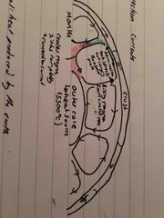
What are the different layers of the earth? |
INNER CORE: It’s is around 1000km thick and composed of iron and nickel. Is solid due to pressure. Density of 15 g/cm3 and heat of 5000-6000 THE OUTER CORE: Around 2300km thick and composed of buckle and iron. Is liquid. Density if 10-20 g/cm3 and heat of 4000-5000 THE MANTLE: Made from Rick called peridotite. Top layer is known as the asthenosphere. Is 75-250km thick. Density of around 4 g/cm3 and heat between 900-1600. THE CRUST: The outer layer, also known as lithosphere. 2 types of crust: continental crust and oceanic crust. |
|
|
|
What is the magnetic fueld |
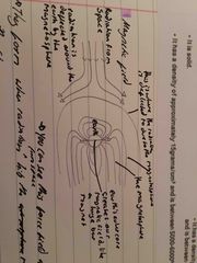
-The earth is surrounded by an invisible magnetic field called the magnetosphere. -Forms when radiation from space hits the magnetosphere and lights up the sky. -The magnetosphere protects the earth from harmful radiation from space and the sun. -The earths magnetic field is made by the outer core. As liquid iron in the outer core flows, it works like and electrical dynamo, producing the magnetic field. |
|
|
|
Convection currents in the earth |
Magna rises from the heated core. It then cools and sinks. Whilst doing this it pulls plates in different directions. |
|
|
|
What was Pangea? |
-Scientists know that the continents were once all joined together. -They formed a super continent called Pangea. -Identical rocks and fossils dating from this time have been found in west Africa and South America. -This tells us that Africa and South America was once joined. -Pangea started to split apart about 200 million years ago. -Since then, the plate tectonics has moved the continents to the positions they are in today. |
|
|
|
Names for plate boundaries |
-CONSERVATIVE BOUNDARIES: boundaries such slide pas each other -CONVERGENT BOUNDARIES: destructible or collision boundaries, those that which are moving towards each other. -DIVERGENT BOUNDARIES: constructive boundaries. Those which move apart from each other. |
|
|
|
Effects of each plate boundary |
1) CONSERVATIVE. Example: San Andreas fault in USA. North America and Pacific plates slide past each other. Earthquakes: destructive earthquakes up to magnitude 8.5, small earth tremors almost daily. No volcanoes. 2) DIVERGENT. Example: ice land in mid Atlantic ridge. The Eurasian and North American plate pulling apart. Earthquakes: small earth quakes (5.0-6.0 on Richter scale). Volcanoes: not very explosive or dangerous, occurs in fissures (cracks in the crust), erupt basalt lava at 1200. 3) CONVERGENT. Example: Andes mountains, nazca plage subduction under American plate. Earthquakes: very destructive (magnitude up to 9.5). Volcanoes: very explosive, destructive volcanoes, steep sided cone-shaped, erupt cooler lava. 4) COLLISION ZONE: Example: Himalayas, formed as Indian and Eurasian plates collide. Earthquakes: destructive earthquakes up to magnitude 9.0, landslides are triggered. Volcanoes: very rare. |
|
|
|
Parts of an earthquake |
Focus: where earthquake starts. Energy travels outwards from the focus as earthquake waves. The shallower the focus, the more destructive. Epicentre: point in the earths surface above the focus. |
|
|
|
Parts of an earthquake |
Focus: where earthquake starts. Energy travels outwards from the focus as earthquake waves. The shallower the focus, the more destructive. Epicentre: point in the earths surface above the focus. |
|
|
|
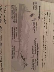
How does a tsunami form? |
-tsunamis are waves that travel at up to 900 km/h with wavelengths of over 200km. -In open ocean, wave height is less than 1m, but as the waves approach the cost they slow down and bunch up and wave height increases up to 30m. -When a tsunami hits, it causes a very powerful flood, pushing several km in land destroying homes, bridges and infrastructure. -Warning systems in the ocean can detect tsunamis and set off sirens and alarms but this is only useful if the epicentre is some distance from the coast. |
|