![]()
![]()
![]()
Use LEFT and RIGHT arrow keys to navigate between flashcards;
Use UP and DOWN arrow keys to flip the card;
H to show hint;
A reads text to speech;
107 Cards in this Set
- Front
- Back
|
Influencing Factors of Wind |
1. Gravity 2. Pressure gradient 3. Coriolis 4. Friction |
|
|
Gravity |
without gravity, there would be no atmospheric pressure, which means no wind |
|
|
Pressure gradient |
drives air from areas of higher barometric pressure (more dense air) to areas of lower barometric pressure (less dense air), which causes wind |
|
|
Coriolis |
makes wind that travels in a straight path appear to be deflected in relation to Earth's rotating surface |
|
|
Friction |
this drags on the wind as it moves across a surface (slows it down) |
|
|
Cyclonic Air Movement |
when Norhern Hemisphere winds spiral counterclockwise into a low-pressure area |
|
|
Anticyclonic Air Movement |
when Northern Hemisphere winds spiral clockwise out from a high-pressure area |
|
|
Global High Pressure Cells |
-polar high-pressure cells at the N & S poles -subtropical high-pressure cells (H) |
|
|
Global Low Pressure Cells |
-equatorial low-pressure trough (ITCZ) -subpolar low-pressure cells (L) |
|
|
ITCZ |
a combination of heating and convergence that forces air aloft |
|
|
Hadley Cells |
air moves northward and southward into the subtropics from the ITCZ, pick up a ton of moisture, and return to the ITCZ as the trade winds |
|
|
Subtropical Highs |
broad high-pressure zones of hot, dry air whose locations shift based upon the SSP |
|
|
Trade Winds |
the winds converging on the ITCZ |
|
|
Polar Lows |
there are two low-pressure cyclonic cells that hang out over the Arctic Oceans region during the winter, but disappear during the summer |
|
|
Polar Fronts |
the area of contrast between the cold and warm air forms the polar front, where the air masses battle |
|
|
Westerlies |
dominant surface winds from the subtropics to high latitudes |
|
|
Upper Atmospheric Circulation |
circulation in the middle and upper troposphere |
|
|
Jet Stream |
an irregular, concentrated band of wind occurring at several different locations that influences surface weather systems |
|
|
Land-Sea Breezes |
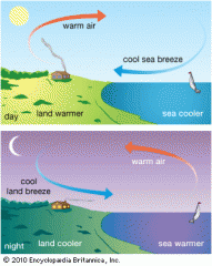
|
|
|
Mountain-Valley Breezes |
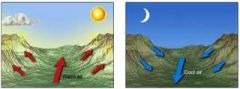
|
|
|
Monsoons |
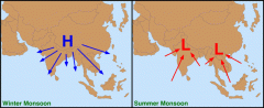
regional wind systems that seasonally change direction. occur in the tropics over SE Asia, Indonesia, India, n Australia, and mid-Africa |
|
|
Distribution of Water |
~97% ocean ~3% fresh (78% of which comes from ice, rivers, lakes and the atmosphere) |
|
|
Water Chemistry & Properties |
water is 2 hydrogen, 1 oxygen molecule (think Mickey-head) H20, it is a versatile solvent and has extraordinary heat characteristics |
|
|
Polarity |
between Mickey's ears (the hydrogen molecules) is where the molecule is positive, and at the bottom of the oxygen molecule is negative, so the water molecules attract each other |
|
|
Hydrogen Bonds |
when water molecules bond because of their polarity |
|
|
Water Phases & Heat Exchange |
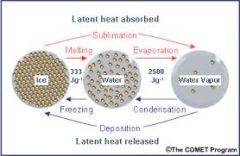
|
|
|
Sublimation vs Deposition |
-sublimation = direct change of ice to water vapor -deposition = direct change of water vapor to ice (frost) |
|
|
Relative Density of the Phases (Most to Least) |
solid, liquid, vapor |
|
|
Relative Humidity |
a percentage of the amount of water vapor that is actually in the air compared to the air's capacity (how much water the air is able to hold) at a given temperature |
|
|
Saturation |
100% rel. humidity, all capacity is filled |
|
|
Dew Point |
the temperature at which a given mass of air becomes saturated and condensation begins to form water droplets (the air is saturated with the dew point temp = actual temp) |
|
|
Adiabatic Processes (ascending and descending, lifting condensation level, DAR, MAR, NLR, ELR) |
describes warming and cooling rates for a parcel of expanding or contracting air -ascending air = cooled by expansion -descending air = heated by compression |
|
|
Lifting Condensation Level |
when you can see in the sky the flat bottoms of clouds |
|
|
Dry Adiabatic Rate (DAR) |
the rate at which "dry" air cools by expansion (ascending) or heats by compression (descending) |
|
|
Moist Adiabatic Rate (MAR) |
the rate at which "moist" air (ascending) is cooled |
|
|
Normal Lapse Rate (NLR) |
the average rate of cooing as you move up the atmosphere |
|
|
Environmental Lapse Rate (ELR) |
the actual rate, which deviates from the Normal Lapse Rate |
|
|
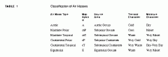
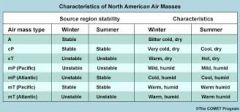
Air Masses |
very large (much larger than parcels) and thick, are able to travel -uniform temp, humidity and horizontal pressure -they reside over either all water or all land -they hang out long enough to mirror properties of the surface below -high pressure, anticyclonic, stable -can modify the surrounding region and can be modified |
|
|
Source Regions |
where an air mass originates |
|
|
Air Mass Classifications |
|
|
|
North American Air Masses Influences (winter & summer) |
|
|
|
Lifting Mechanisms |
forms of lift that cause air to rise; important in the formation of clouds and rain |
|
|
Convergence |
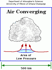
air from many directions flows to the same low-pressure point and lifts up |
|
|
Convection |
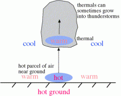
warm air gathers and moves up over urbanized areas and vegetation |
|
|
Orographic |
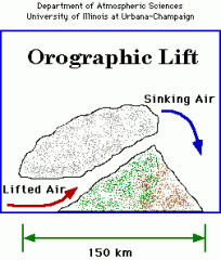
air is forcibly moved upslope as it is pushed against a mountain |
|
|
Frontal (clouds and precip) |
when air masses of different properties come into contact |
|
|
Cold Fronts |
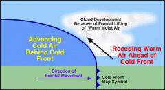
cold air is more dense than warm air, and as a result, it undercuts and pushes the warm air vertically ahead of it as it moves |
|
|
Warm Fronts |
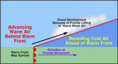
unlike a cold front that undercuts the air at the surface, the warm air of a warm front will rise over the cooler air at the surface due to its lower density |
|
|
Mid-Latitude Cyclones (causes) |
aka wave cyclones; caused by a conflict between contrasting air masses and a combination of the pressure gradient force, the coriolis force, and surface friction |
|
|
Thunderstorms |
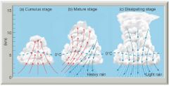
lots of energy + lots of heat = thunderstorms |
|
|
Why does Florida get a lot of thunderstorms? |
Florida gets a lot of thunderstorms because of maritime tropical air, convectional movement, high temps (low pressure) and its location on the tropical storm pathway |
|
|
Tornados |
spawned from meso-cyclones (really widespread).. Supercell Tornado Hypothesis: rolling Slinky winds (faster on top than underneath) + convective lifting = rolling clouds that turn vertically and a funnel cloud forms.. measured on Fajitia scale (F0, F1... F5) |
|
|
Tropical Cyclones (Hurricanes) |
caused by Easterly waves, which are low-pressure systems originating over Africa that suck up a ton of water loaded w/ latent heat (fueled by warm ocean water).. Measured on the Saffir-Simpson scale (cat 1-5) |
|
|
Difference b/t mid-latitude cyclones and tropical cyclones |
cyclonic systems forming in the tropics are located in relatively homogeneous air masses, with no fronts or conflicting temps.. tropical cyclones convert heat energy from the ocean into mechanical energy in the wind (warmer ocean=more powerful storm) |
|
|
Things to consider from the Katrina video... |
-Saffir-Simpson scale -pressure -storm surge -size -location (population, development, engineering) -emergency prep |
|
|
Landfall of a Hurricane |
the point at which the storm moves from sea to land, the most destruction happens here |
|
|
Storm Surge |
high tides and large amounts of water, leading cause of hurricane-related deaths |
|
|
Human errors in the Katrina video... |
-levee failure (poor engineering) -draining of the wetlands -city built below sea level (in a bowl shape) -ignored warnings |
|
|
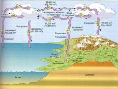
Hydrologic Cycle (The Water Cycle) |
open system, "global plumbing," involves circulation & transformation of water throughout atmosphere |
|
|
Surface Water: Infiltration |
when precip penetrates the soil |
|
|
Surface Water: Interception |
when precip strikes vegetation of other ground cover |
|
|
Surface Water: Percolation |
when it further permeates through soil & rock |
|
|
Surface Water |
precip water will either flow over land or sink into the soil |
|
|
Infiltration |
when precip water penetrates the soil |
|
|
Percolation |
when precip water further permeates through soil and rock |
|
|
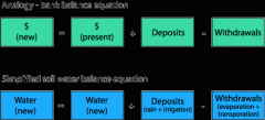
Soil Water Budget |
|
|
|
Soil-Water Budget: PRECIP |
the deposit/input (paycheck) |
|
|
Soil-Water Budget: ACTET |
output/withdrawl; actual evapotranspiration (combination of evaporation and transpiration) |
|
|
Soil-Water Budget: Evaporation |
output/withdrawl; movement of free water molecules into the air, which is less saturated |
|
|
Soil-Water Budget: Transpiration |
output/withdrawl; a cooling mechanism of plants |
|
|
Soil-Water Budget: Potential Evapotranspiration (POTET or PE) |
output/withdrawl; the amount of water that WOULD evaporate or transpire under optimum circumstances |
|
|
Soil-Water Budget: Deficit (DEFIC) |
the unsatisfied portion of the POTET |
|
|
Soil-Water Budget: Surplus (SURPL) |
additional water input |
|
|
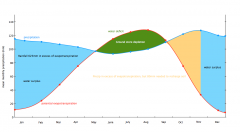
Sample Water Budget |
|
|
|
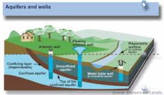
Groundwater |
begins as surplus, moves into zone of aeration and then into the zone of saturation |
|
|
Zone of Aeration |
where soil and rock are less than saturated with groundwater and some pores contain air |
|
|
Zone of Saturation |
surface water accumulates and all pores are filled with water (the ceiling of the zone of saturation is the water table) |
|
|
Aquifers |
a rock layer that is permeable to groundwater flow |
|
|
Aquicludes |
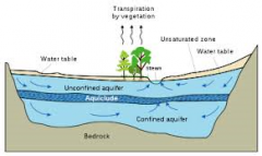
a body of rock impenetrable by water |
|
|
Confined Aquifers |
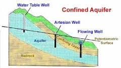
aquifers sandwiched between 2 aquicludes (the zone of recharge is much smaller here) |
|
|
Zone of Recharge |
where precip water can penetrate to the water table |
|
|
Unconfined Aquifers |
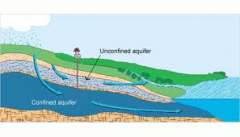
permeable layer on top and an impermeable one beneath |
|
|
Overuse: Drawdown & Cone of Depression |
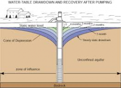
the surrounding water table of a working well is lowered |
|
|
Effluent Streams |
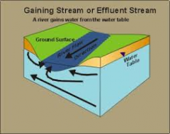
stream base flow is partially supplied by a high water table (mainly humid regions) |
|
|
Influent Streams |
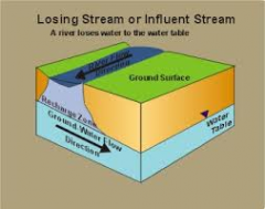
stream supplies a lower water table (mainly drier regions) |
|
|
High Plains Aquifers |
-irrigates about 20% of all crops in the US -is depleting from overuse and overpumping -could be half-gone by 2020 at this rate |
|
|
Climate |
weather over time, studied by climatologists |
|
|
Climatic Regions |
areas with similar weather statistics |
|
|
5 Climate Components |
1. insolation 2. temp 3. pressure 4. air masses 5. precip |
|
|
Genetic Climate Classification |
defining climate based on causative factors (ex: the interaction of air masses) and explains climates through net radiation, thermal regimes, and air mass dominance over a region |
|
|
Empirical Climate Classification |
determined by statistical data of observed effects (ex: temp and precip data of the Koppen system) |
|
|
Basic Climate Categories: Tropical Rainforest |
rainy all year, ITCZ |
|
|
Basic Climate Categories: Tropical Monsoon |
6-12 mos. of rain, ITCZ and subtropical high |
|
|
Basic Climate Categories: Low-Latitude Hot Desert |
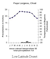
subtropical high |
|
|
Basic Climate Categories: Marine West Coast |
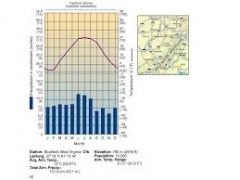
moist all year, mild temps, sea-surface temps and marine effect |
|
|
Basic Climate Categories: Mediterranean |
summer drought, hot-warm, b/c of subtropical high |
|
|
Basic Climate Categories: Subarctic Cold Winter |
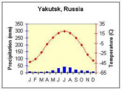
very dry, cold winters b/c of Westerly winds and cP air masses |
|
|
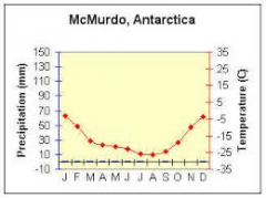
Basic Climate Categories: Polar |
|
|
|
Global Climate Patterns: ENSO |
ENSO = El Nino/Southern Oscillation, occurs every 3-7 years in the southern Pacific Ocean |
|
|
El Nino |
refers to a change in sea surface temps |
|
|
Southern Oscillation |
refers to a change in air pressure
|
|
|
Global Climate Patterns: ENSO Effects |
bad for fisheries, droughts in Mexico, coral bleaching, heavy rain/snow in CA, wildfires in AZ & NM |
|
|
Global Climate Change |
warming caused by an increase in greenhouse gasses (GHG's like H2O, CO2, Methane, N2O) |
|
|
Global Warming Potential (GWP) |
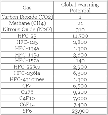
ratio of warming (radiative forcing) from one unit of GHG to one unit of CO2 over 100 years |
|
|
IPCC |
Intergovernmental Panel on Climate Change |
|
|
2 Type of Data Used in Climate Change Research |
1. data and observations 2. proxy data (ice cores, tree rings, coral reefs, pollen deposits & sediments) |
|
|
Calibration |
comparing proxy data to observed data |