![]()
![]()
![]()
Use LEFT and RIGHT arrow keys to navigate between flashcards;
Use UP and DOWN arrow keys to flip the card;
H to show hint;
A reads text to speech;
164 Cards in this Set
- Front
- Back
|
What is Geomorphology |
The Science of Scenery The scientific study of Earth's surface materials, processes, and resulting landforms |
|
|
Why is Geomorphology relevant |
Land use applications- planning Agriculture, Forestry, Mining Stream/ Watershed management Geological Hazards Resources (sand, gravel, minerals) |
|
|
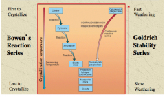
Contribution of Leonardo da Vinci |
1452-1519 Studied topography of Arno River Basin and drew first contour map of a whole basin Believed rivers carved valleys and shaped topography |
|
|
Contribution of Nicholas Steno |
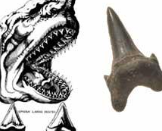
1638-1686 Fossilized shark teeth on mountain tops didn't fall from the sky Idea of original horizontality and Steno's law of superposition |
|
|
Law of Superposition (Steno) |
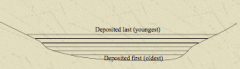
Sedimentary layers are deposited in a time sequence with the oldest layers at the bottom and the youngest ones on the top |
|
|
Contributions of James Hutton |
1726-1797 Wrote the Theory of Earth Recognized that most present rocks come from destruction of other more ancient formations |
|
|
Contributions of Sir Charles Lyell |
1797-1875 Advocated the doctrine of uniformitarianism Published Principles of Geology in 1830's Rock layers can be correlated based on their fossil content Glaciers transported erratics |
|
|
Uniformitarianism |
Theory that slow geomorphic processes have occurred throughout history and are still occurring today |
|
|
Catastrophism |
Theory that the Earth's features formed in a single, catastrophic event and remained largely unchanged thereafter |
|
|
Contributions of John Wesley Powell |
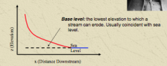
1834-1902 Introduced the idea of Base Level |
|
|
Contributions of Grove Karl Gilbert |
1843-1918 First to systematically discuss: Weathering and Bedrock Erosion Erosion and Transport of Sediments Interactions between erosive and resistive forces Dynamic adjustment between form and process Graded Streams |
|
|
Graded Stream |
A stream in which over time slope is adjusted to yield the velocity required for the transport of the load supplied from the drainage basin |
|
|
Davis' Cycle of Erosion |
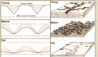
1909 landscapes develop according to an evolutionary fluvial "Cycle of Erosion" youthful-mature-old age-youthful |
|
|
Peneplain |
the final stage of a river's cycle of erosion, once base level is reached |
|
|
Newton's 2nd Law |
F=ma |
|
|
Force |
a phenomenon causing motion of mass has both magnitude and direction |
|
|
Work |
product of Force moving Mass over Distance w=Fd w=mad Measured in Joules (J) |
|
|
Fundamental Considerations |
Time Space Process Morphology Composition |
|
|
Critical concepts in modern geomorphology |
1. A delicate balance (equilibrium) exists between processes and the landforms that develop 2. The perceived balance is created by forces that drive landform change and resistance to change 3. changes in the driving forces or resisting forces can push a system past a threshold 4. The balance and thresholds are all scale dependant |
|
|
Frequency |
#occurrences/unit time |
|
|
Magnitude |
E used or M moved / unit time by a geomorphic process |
|
|
Recurrence interval (return period) |
R=(n+1)/m n= number of records m= magnitude ranking |
|
|
Probability (%) |
P= (R-1)x100 R=recurrence interval |
|
|
What type of events do the most work in geomorphic systems? |
Moderate size and frequency |
|
|
4 types of equilibrium |
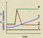
1. Static- unchanging 2. Stable- revert to previous state after disturbance 3. Unstable- small disturbance causes movement away from equilibrium 4. Metastable- Incremental change from one to another equilibrium |
|
|
Steady State Equilibrium |
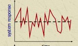
Fluctuations around some average non-trending state |
|
|
Thermodynamic Equilibrium |

Trend towards maximum entropy |
|
|
Dynamic Equilibrium |
Fluctuation about a trending, non-repetitive mean |
|
|
Dynamic Metastable Equilibrium |
Fluctuation about a trending mean with abrupt shifts to new equilibrium states |
|
|
Threshold |
limit within a landform or process beyond which equilibrium cannot be maintained |
|
|
Reaction Time |
to Lag from disturbance/ change in E to morphological response |
|
|
Relaxation time |
tr adjustment time of form/ process to new equilibrium |
|
|
For process response models the negative feedback between components can be summed. What does the answer mean? |
If there is an odd number of negative feedbacks- the system is negative
If there is an even number of negative feedbacks- the system is positive |
|
|
Endogenic proceses |
processes driven by energy from inside the earth |
|
|
Exogenic processes |
processes driven by gravity and atmospheric forces |
|
|
Batholiths |
intrusive rock that may be exposed later by erosion |
|
|
Folding |
plastic deformation of rocks under compressional stress |
|
|
Faulting |
fracture of brittle rock |
|
|
Why is weathering a disequilibrium response of rock bodies or sediment? |
Conditions at the surface are different than from those of rock formation ex. heat, pressure, chemistry, mechanical action |
|
|
What are the 2 main types of weathering |
Chemical Physical (mechanical) |
|
|
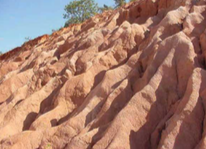
Physical Weathering examples |
Pressure release Freeze-thaw Thermal expansion Salt crystal growth Biotic Hydration |
|
|
Chemical Weathering examples |
Solution Ion Exchange Hydrolysis Oxidation |
|
|
Mechanical Weathering definition |
No change in chemical composition- just disintegration into smaller pieces |
|
|
Chemical Weathering definition |
Breakdown as a result of chemical reactions |
|
|
Pressure Release |
as rock is uncovered it expands, resulting in exfoliation |
|
|
Frost Wedging |
Breakdown caused by expansion of ice in cracks and joints. Controlled by: moisture content, rate of temp change, # freeze thaw cycles, rock type Common in high latitude and high altitude |
|
|
Thermal Expansion and Contraction |
Expansion or contraction due to extreme temp changes Often in Deserts Enhanced by moisture |
|
|
Salt Crystallization |
Saline solutions seep into cracks and joints and evaporate, leaving salt crystals The crystals expand when heated, pressuring the confining rock Sandstone particularly susceptible |
|
|
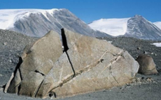
Tafoni |
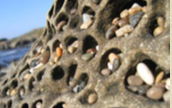
Salt weathering that forms a honeycomb pattern Common in arid coastal areas where brine is abundant and salt crystallization is possible |
|
|
Biotic Weathering |
Tree seedlings, Lichens, Burrowing animals.... |
|
|
Hydration and Swelling |
Attachment (adsorption) of water molecules to the crystalline structure of a mineral; causes expansion and increased stress in the rock ex. hydration of anhydrite, expanding clays, conversion of hematite to limonite Note: these processes are reversible |
|
|
What rock characteristics control the rate of physical weathering? |
strength composition grain size structure cementation |
|
|
Driving forces of physical weathering |
Water (moisture content - climate controlled) Temperature (especially change and freeze-thaw) |
|
|
Resisting forces for physical weathering |
Rock strength (cementation) Grain size (fine more resistant) Massive more resistant than highly jointed |
|
|
Solution |
process by which rock is dissolved in water ex acid rain |
|
|
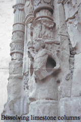
Karst landscapes are a result of what type of weathering? |
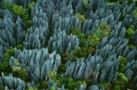
Chemical weathering Solution |
|
|
What is a danger in Karst landscapes |
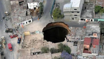
sinkholes |
|
|
Ion Exchange |
Substitution of ions in solution for those held by minerals Important in clay minerals |
|
|
Hydrolysis |
Combination of H and O in water with rock to form new substances. Mostly affects silicate and carbonate minerals to form clay minerals. Most common mechanism for clay formation |
|
|
Oxidation |

Oxygen dissolved in water promotes oxidation. Oxidation of metals is especially common |
|
|
What is the main driver of Chemical Weathering |

Water |
|
|
Which minerals are most resistant to chemical weathering |
Those that crystal last Quartz, Muscovite mica, Potassium feldspar |
|

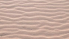
Why is sand so prevalent at earth's surface |
It is composed of quartz, a relatively stable mineral |
|
|
What other planets have sand dunes |
Mars, Pluto |
|
|
How are physical and chemical weathering interrelated |
physical weathering increases surface area creating more area for chemical reactions to occur |
|
|
What climate has the most chemical weathering |
High temperature and High precipitation |
|
|
What climate has the most physical weathering |
Low temperature and moderate precipitation |
|
|
Rheology |
the study of flow and deformation of materials under applied forces |
|
|
Stress |
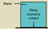
force applied to a surface area |
|
|
Strain |
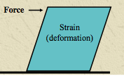
deformation of a material caused by stress |
|
|
Tensile stress |
Pulling <---- ----> |
|
|
Compressive stress |
Crushing ---><--- |
|
|
Shearing stress |
Sliding ----> <---- |
|
|
Elastic materials |
will return to original shape once the applied force is taken away, so long as the yield stress hasn't been reached |
|
|
Plastic materials |
do not deform without sufficient applied stress and do not return to original shape when force is removed |
|
|
Atterberg Limits |
measurement of critical water content in fine grained soils |
|
|
Shrinkage Limit (SL) |
the water content where further loss of moisture will not result in any more volume reduction |
|
|
Plastic Limit (PL) |
the water content where material transitions from plastic to nonplastic behaviour |
|
|
Liquid Limit (LL) |
the water content boundary between plastic and viscous liquid |
|
|
Plasticity Index (PI) |
PI= LL-PL |
|
|
Boulder |
>256mm |
|
|
Cobble |
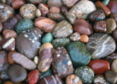
64-256 mm |
|
|
Gravel |

2-64mm |
|
|
Sand |
0.064-2mm |
|
|
Silt |

0.002-0.064mm |
|
|
Clay |
<0.002mm |
|
|
Kurtosis |
Peakedness in the shape of distribution |
|
|
Porosity |
volume of voids |
|
|
Pore Water Pressure |
Positive- suction Negative- hydrostatic |
|
|
How many people died in the Frank Slide |
about 70 |
|
|
What is friction dependent on |
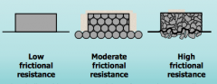
The Material surface roughness, packing and grain shape |
|
|
What factors control rheological response |
Cohesion (how well things stick together) Internal Friction (planar friction angle) |
|
|
Angle of Repose |
angle of rest of dry sediment (25-40 degrees) |
|
|
Angle Sliding Friction |
Angle at which sediment fails up to 10 degrees > than angle of repose |
|
|
What is the primary driving force in the landscape |
gravity |
|
|
Friction does what as slope increases |
decreases |
|
|
What increases as slope increases |
the down slope gravitational component |
|
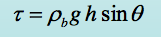
explain the variables |
|
|
|
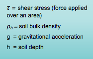
What factors control Soil Strength (S) |
soil cohesion normal force pore water pressure friction |
|
Explain the variables |
|
|
|
What is cohesion caused by |
roots or inter-particle bonds |
|
|
What is the effect of pore water pressure |
pore water pressure forces particles apart so it reduces friction |
|
|
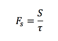
Factor of Safety equation |
|
|
|
Factor of Safety results |
Fs=1 forces balanced, threshold for instability Fs>1 stable Fs<1 unstable |
|
|
What happens to Fs if slope angle is increased |
denominator increases and numerator decreases do Fs decreases |
|
|
What happens to Fs is a wet soil loses its moisture |
Numerator increases so Fs increases |
|
|
What happens to Fs if a slope is logged |
cohesion decreases so the numerator decreases and Fs decreases |
|
|
What happens to Fs if soil thickness increases |
the denominator gets larger proportionally to the numerator and Fs decreases but if there is cohesion it can balance out |
|
|
What factors increase shear strength |
Removal of lateral support Addition of mass Earthquakes Regional tilting Removal of underlying support Lateral Pressure |
|
|
What factors decrease shear strength |
Weathering Pore Water Structural Changes |
|
|
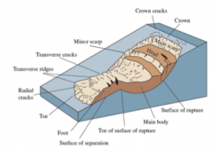
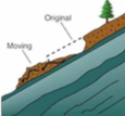
Parts of a Landslide |
|
|
|
5 main types of mass movement |
Falls Topples Slides Spreads Flows |
|
|
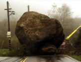
Rockfall |
free or bounding downslope movement of loose rock under the influence of gravity |
|
|
Topples |
the forward rotation outward from slope with axis of rotation below the centre of gravity |
|
|
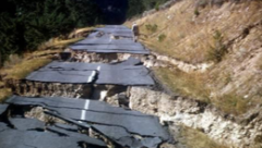
Slides |
movement of soil, sediment or rock mass along a failure plane with relatively thin zones of intense shear |
|
|
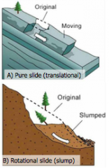
Translational Slide |
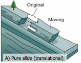
planar rupture surface roughly parallel to the ground surface and often shallow |
|
|
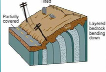
Rotational Slide (Slump) |
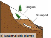
rupture along a concave surface- rotation lowers the head and raises the toe |
|
|
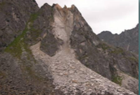
The Frank Slide |
Classified as sturzstrom or fluidized granular flow |
|
|
What 2 processes are active at Turtle Mountain (Frank Slide) |
Slow movement of loose rock deposited on the lower slope Subsidence over abandoned coal mines |
|
|
What causes or triggers slumps |
Moisture Under cutting Over steepening Loading Logging |
|
|
What type of slide was La Conchita |
1995- Rotational Slump with an earthfolw 2005- small, fast landslide |
|
|
Lateral Spread |
Extension of a cohesive mass overlaying deformable material common in areas of quick clay |
|
|
Debris Flow |
viscous movement of soil and or weathered bedrock common in BC |
|
|
What initiates Debris Flows |
rapid addition of water by: Extended periods of rainfall Localized intense rainfall Ponding on surface Snowmelt or rain on snow |
|
|
What are the most damaging mass movements in BC |
Debris Flows |
|
|
Debris Flow Prerequisites |
Abundant Water Abundant Fine Sediment Steep Slopes (>15%) |
|
|
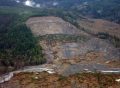
Mt. Meager |
Debris Flow Largest slide in Canadian history |
|
|
Earth Flows |
Mass movement of relatively dry, fine-grained material |
|
|
Lemieux landslide |
small landslide in 1971 study of the clays concluded Lemieux was in danger, abandoned 1991 1993 rapid earthflow |
|
|
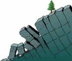
Creep |
upward heave with downslope (plastic) displacement |
|
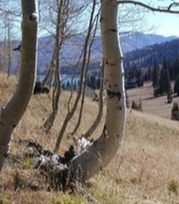
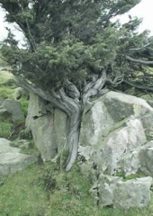
What are pistol butt trees an indication of |
Creep |
|
|
Solifluction |
creep in saturated sediments |
|
Oslo |
Rotational lots of rainfall logging in upper watershed river undercut |
|
|
Fluvial Geomorphology applications |
ecology population dynamics environmental chemistry flood protection |
|
|
As river discharge increases what happens to width, depth and velocity |
they all increase |
|
|
What 4 dimensions does velocity vary in |
distance from the bed
across the stream downstream with time |
|
|
Laminar flow |
water travels along parallel paths with no significant mixing |
|
|
Turbulent flow |
chaotic movement of water fluctuations in velocity considerable mixing irregular paths of fluid flow |
|
|
What does Reynolds number describe |
the ratio between driving and resisting forces. Re < 500 laminar flow Re > 2000 turbulent flow |
|
|
Froude number |
compares inertial and gravitational forces Fr < 1 subcritical - deep, tranquil flow Fr > 1 supercritical- shallow, fast flow |
|
|
Luna Leopold
|
head of USGS Hydrology 1950's and 60's invented Hydraulic geometry |
|
|
Flooding |
flow that exceeds channel banks onto the floodplain |
|
|
Rills |
small parallel channels |
|
|
Gullies |
channels that are larger than rills and not easily undone |
|
|
Sheet flow |
overland flow as a shallow layer |
|
|
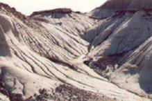
Colluvial zone |
mass wasting and bedrock channels typically channels are v shaped |
|
|
Alluvial zone |
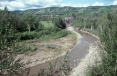
rivers flow through their own deposits typically wide lowland channels |
|
|
Depositional zone |
dominated by wide, low gradient floodplains deltas, alluvial fans |
|
|
Delta |
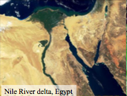
where a river enters a body of water and drops its sediment load |
|
|
Alluvial Fan |
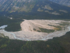
deposition on land, usually a river leaves the confines of a narrow constriction and flows into a broad valley or plain |
|
|
Drainage density |

an empirical relationship between the drainage basin area and the total length of streams in the basin |
|
|
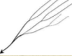
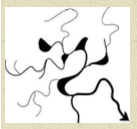
Dendritic drainage |

Tree-like most common confluences of tributaries at acute angles |
|
|
Parallel Drainage |
where there is a pronounced, uniform slope confluence of tributaries at very small angles |
|
|
Trellis Drainage |
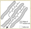
develop in folded topography short streams enter main channel at almost right angles |
|
|
Rectangular Drainage |
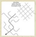
develop in regions with faulting or joining confluences at almost right angles |
|
|
Radial Drainage |

Develop around a central point. Can flow into the point (ex. crater) or away from the point (ex. dome) |
|
|
Deranged drainage |
no pattern |
|
|
Straight Stream |
low sinuosity single channel |
|
|
Braided Stream |
low sinuosity multiple channel |
|
|
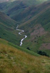
Meandering Stream |
high sinuosity single channel |
|
|
Anastamosing or Anabranching Stream |
high sinuosity multiple channel |
|
|
What controls channel morphology |
the caliber and quantity of sediment the shear stress available to move the sediment |
|
|
Stream competence |
maximum particle size that can be transported |
|
|
Stream capacity |
theoretical maximum mass of suspended sediment transported by a stream |