![]()
![]()
![]()
Use LEFT and RIGHT arrow keys to navigate between flashcards;
Use UP and DOWN arrow keys to flip the card;
H to show hint;
A reads text to speech;
10 Cards in this Set
- Front
- Back
|
What is a geoid |
Equipotential surface of Earths gravity field that approximates the mean sea level and can’t be mathematically defined |
|
|
What is an ellipsoid |
Arbitrary mathematically define geometric construct that approximates the Earths surface and is defined by the semi-minor , semi-major axes and flattening |
|
|
Reference 4 ellipsoids |
World Geodetic System 84 Geocentric Datum Australia 2020 and GDA 94 Australian National Spheroid Australian Geodetic Datum 66 |
|
|
5 projections |
Gnomonical, Azimuthal, Stereographic, Conic, Cylindrical |
|
|
Latitude |
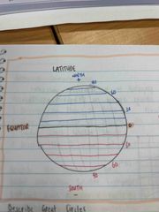
Circles running around the globe parallel to the Equator measured from the Equator being 0° |
|
|
Longitude |

Semi-circles travelling north to south from one pole to the other measured from the Greenwich Meridian being 0° |
|
|
Great circles |
Cutting a sphere in two equal halves and has the same circumference and radius as the sphere. Provides shortest path between two points on Earths surface |
|
|
Great circle angles |
Angles formed on the surface of a sphere when measured along the circumference of a great circle. Provides a way to navigate and calculate distances on a spherical surface |
|
|
Define grid |
A system of squares placed on a projection so computation and plotting of data can be done using simple trig |
|
|
Relationship between geodesy projections and grids |
Geodesy projections represent Earths curved surface on a flat map that’s lat and long lines appear distorted making calculations difficult. Grids aid in computation and plotting of data using a system of squares overlaying the projection making calculating simple trig easier |