![]()
![]()
![]()
Use LEFT and RIGHT arrow keys to navigate between flashcards;
Use UP and DOWN arrow keys to flip the card;
H to show hint;
A reads text to speech;
145 Cards in this Set
- Front
- Back
|
Tephra = Pyroclast |
Particles ejected explosively from a volcano. Travel through air, carried by wind, and eventually land on the ground. |
|
|
How does tephra fallout deposits effect the terrain? What happens as they get further from the volcano? |
These deposits mantle the terrain and thin, often exponentially, with distance from the volcano. |
|
|
Vulcanian/Plinian tephra (2) |
Pumacious lapilli, pumice blocks. |
|
|
Three genetic types of pyroclastic deposits |
Fall: Mainly vertical transport Surge Flow |
|
|
Grain-size unit: |
Diapositive 1 ɸ (phi) = - log2 d, where d isthe grain diameter in mm |
|
|
Pyroclastic Fall Deposit Characteristics (6) |
- Blankets topography - Well sorted - Can be internally stratified - Often mm-cm - Thins and fines downwind - No evidence of high-T emplacement |
|
|
Pyroclastic Flow/Surge Characteristics (6) |
- Fills topography - Poorly sorted (flows) to moderately well sorted (surges) - Unstratified (flows) to moderatley stratified (surges) - Often 1-100s m thick - Thickness, grain size not systematic with distance from vent - Evidence of high-T emplacement |
|
|
Why study fall deposits? (4) |
- Most simple - Great value to infer eruption parameters - Proxies for intensity and eruption style - The most widespread of volcanic hazards. |
|
|
How is grain size categorized? What is sorting based on? |
Fine, medium, coarse and as ash, lapilli, and blocks/bombs. How poorly or well sorted. |
|
|
Strombolian Scoria Fall Deposit (3) |
Mild explosive activity builds scoria/cinder cones Deposits of these cones are often poorly bedded and coarse grained; may contain spatter and bombs/blocks Scoria is sometimes red (oxidation) |
|
|
Plinian Pumice Fall Deposit (3) |
Well sorted May be unstratified or show internal stratification depending on eruptive column conditions May be normally or reversely graded due to variations in eruption intensity |
|
|
Isopach Map:
What are isopachs? What are they used to determine? What indication does fragmentation and dispersal give? |
- Isopachs are a contour of same deposit thickness - Used to determine vent position and deposit volume - Fragmentation and dispersal gives indication of eruption type and intensity/magnitude |
|
|
Fragmentation level |
At a depth where 70% of lava is bubbles.
|
|
|
Reverse grading Normal grading |
- Clasts get bigger as you go up. Intensity of eruption increased. -Clasts big at base. Intensity of eruption decreased. |
|
|
Welded pyroclastic fall deposits |
Happens when accumulation is very fast and the deposits weld together. No evidence of flow, hard to determine as a fall deposit. |
|
|
Isopleth maps What are they used to infer? What information does it give? |
Isopleths are contours of same maximum clast size. Used to infer vent position, eruption column height, and mass or volume eruption rate. Used for information about wind patterns at time of eruption. |
|
|
As you go downwind (5): |
- Decrease in thickness - Decrease in max grain size - Increase in sorting - Changes in component population - Decrease in terminal fall velocity |
|
|
Pyroclastic fall deposits: Class 1 Class 2 Class 3 Class 4 |
Coarse fragments ejected from the jet. Convective region Umbrella cloud Fine particles dispersed in atmosphere |
|
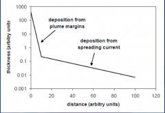
Model of tephra transport based on the particle Reynolds number |
Deposition from plume margin: Fall closer to vent Deposition from spreading current: Falls further away |
|
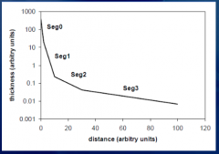
Model of tephra transport based on the particle Reynolds number |
Seg 0: Sedimentation from plume margins Seg 1: High Reynold's number particles settling Seg 2: Intermediate Reynold's number Seg 3: Low Reynold's number |
|
|
If there is no wind, isopleths will be: If there is wind: |
- Circular - They will stretch downwind |
|
|
What can be used to estimate column height? |
Grain size and clast dispersal |
|
|
Fragmentation |
A measure of how thoroughly the magma is blown apart, can be determined from mapped deposits |
|
|
What controls the type of deposit produced near the vent in an explosive eruption? |
Mass flux and the exsolved volatile content. |
|
|
What is the pyroclast accumulation rate directly proportional to? |
The erupted mass flux. |
|
|
What does a high volatile content mean for the pyroclasts speed? |
It causes them to be erupted at high speeds and to travel further, giving them a greater opportunity to cool |
|
|
Three main types of lava flow: |
Pahoehoe: Has a shiny, smooth, glassy surface. It tends to be more fluid (lower viscosity). Aa: Rough, sharp lava, has a molten core, with higher viscosity. Blocky: Similar to aa but even thicker. Andesites, dacites, and rhyolites tend to form blocky flows. |
|
|
Basaltic Lava vs Dacite (thickness, length, volume) |
Basaltic: 2-30 m thickness, 1-90 km length, 0.5 - 1200 km^3 volume Dacites: 20-300 m thickness, 0.5-10 km length, 1 km^3 volume |
|
|
Viscosity and Yield Strength are the two most important factors that influence (3): |
- Surface morphology - Size, shape, thickness, velocity, and length of the flow - Eruption rate |
|
|
When is a fluid considered Newtonian? What can cause the flow to become non-Newtonian? |
If there is a linear relationship between stress and strain. Increasing crystal content and decreasing temperature. |
|
|
Two ways to measure lava viscosity |
- Measure the resistance to a rotating paddle - Estimate from chemical composition and crystal/volatile content |
|
|
What behavior accounts for levees, ripples, and channels? How are levees formed? |
- Non-newtonian. - Levees are built due to decrease in velocity at the margins, blocks accumulate at margins, and the velocity is highest in the middle. |
|
|
Lava flows cool faster on... |
Top and slower on the bottom, the slower cooling forms columnar joints, above that, is tabular irregular columns. |
|
|
What is flow thickness related to? |
Yield strength, and slope. |
|
|
What controls flow length (5)? |
- Effusion rate - Yield strength and viscosity - Development of tubes and channels - Slope - Total volume |
|
|
Crystalline solids follow a well-defined path: Non-crystalline solids (glasses): |
-Thermodynamically stable path - Non-equilibrium path - Favored by fast cooling & high viscosity |
|
|
Lava dome shapes and aspect ratio depends on: |
Magma composition, viscosity, gas content, extrusion rate, and exogenous/endogenous growth |
|
|
Exogenous dome formation (5): |
1) Flowage 2) Formation of crack ejection of gas 3) Continuous growth of crack 4) Deformation 5) Fragmentation and generation of block and ash flow |
|
|
Endogenous dome formation (4): |
1) Intermittent magma supply 2) Local bulge 3) Rock-fall 4) Collision and conversion to block and ash flow |
|
|
Exogenous dome growth vs Endogenous dome: |
- Grows layer on layer on top of each other - First layer will be biggest, the second will grow on the inside |
|
|
The two different types of lava dome growth depend on: |
Mass flux & effusion rate |
|
|
Pyroclastic density current: |
Fast flowing mixture of tephra and gas, which is generated during explosive eruptions or by the collapse of lava domes. |
|
|
Debris avalanche: |
Product of a large-scale collapse of a sector of a volcanic edifice that is not water saturated and in which the load is entirely supported by particle-particle interactions. |
|
|
What are characteristic topographic features of a debris avalanche? |
An amphitheater at the source and hummocky topography on the surface of the deposit. |
|
|
Lahars |
A water-saturated flow (debris flow with more than 50 % sediment, transitional flow or hyper concentrated flow with 20-50 % and muddy streamflow with less than 20 % sediment) originating at a volcano. |
|
|
Four generation mechanisms of pyroclastic density currents: |
1) Gravitational dome collapse: Can move 360 degrees around volcano 2) Explosive dome or subsurface dome collapse: Moves in 1 direction 3) Collapse of column 4) Fountaining at vent |
|
|
Transport system vs Depositional system |
Transport: Responsible for movement of the assemblage of fragmented material (including gas) Depositional: Controls on the way in which the material comes to rest to form a deposit |
|
|
Effect of particle concentration vs angle of trajectory: |
Fall: vertical trajectory, low concentration Surge: Lateral trajectory, low concentration (leads to lower density than flow) Flow: Lateral trajectory, high concentration (higher density than surge) |
|
|
Flows (3) vs Surges (3): |
Flows: - Higher density - Particles concentrated at bottom, velocity highest here - Sharp boundary between high density and low density Surges: - Low density - Lots of drag so the velocity is slowest at the bottom, increases towards the top - Gradual decrease from high to low density |
|
|
Flow-boundary zone |
The boundary between your flow and your deposits. Particles falling below the boundary zone will be deposited. Above will be transported. |
|
|
How does the flow-boundary control the flow regime of a PDC? |
The more mass that is coming out, the flow boundary will be closer to the ground. |
|
|
Controls on Depositional Characteristics (4): |
Particle trajectory: Vertical yields mantling of topography; horizontal may lead to bedding Particle concentration: Low concentration can lead to good sorting (fall); high can lead to poor sorting (flow) Particle cohesion: Allow deposit to be placed on steeper slopes Fluctuation in particle concentration: Uniformly graded deposits vs not. |
|
|
Flow units in pyroclastic flow deposits (3): |
- Instantaneous deposition due to rapidly diminishing current. - Thickness of flow unit = parent flow - Structure of deposit reflects flow dynamics |
|
|
Progressive aggradation |
Lower layer represent early current . |
|
|
Three regimes: |
Granular (coarse-grained and thick), fluid escape (moderate), traction dominated regime (diluted). |
|
|
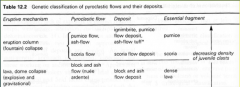
Three main types of pyroclastic flow deposits: |
- Block and ash flow deposit: Small volume PF. Dense, angular fragments in a fine matrix. Often formed by gravitational dome collapse. - Scoria flow deposit: Vesicular, basaltic. Formed by column collapse. - Pumice flow deposit or ignimbrite: Low density, felsic, fine matrix. Formed by column collapse. |
|
|
Welding in ignimbrites |
- Some ignimbrites are highly welded and look like lava flows with columnar jointing. They may deform and flow after deposition. - Degree of welding varies spatially within deposit: Welding is favored by high T and thicker deposits |
|
|
Flow units with ignimbrites |
Pumice clasts coarsen upwards towards top, lithics concentrated at base. |
|
|
Overall summary of pyroclastic flows and their deposits |
|
|
|
Pyroclastic Surges - Terminology Three types |
Are dilute, low particle concentration PDC's with a high gas (and air) component that move fast and turbulently. Often highly destructive and accompany or precede pyroclastic flows. Ground surges, ash-cloud surges, base surges. |
|
|
Base surges |
Result from phreatomagmatic eruptions. Cold & wet. |
|
|
Surge Deposits - Bedforms |
Deposits are stratified, laminated or massive. Characteristically, they show unidirectional sedimentary bedforms. |
|
|
Progressive bedform |
Downstream migration of deposits. Aggrade away from vent. Regressive bedforms do the opposite. |
|
|
Sector collapse definition What do they affect? What is the product? Where are the common? |
A destructive volcanic process during the growth history of a volcano. - They affect the volcanic conduit. - Debris avalanches are the products. - Very common at oceanic island arcs, hot spots, and subduction areas. |
|
|
How are flank collapse and sector collapses different? |
Flank collapse does not involve the magmatic conduit like sector collapse does. |
|
|
What are the parameters that control the occurrence of sector collapses (6)? |
- Edifice stability - Erosion vs construction rates - Magma production and eruptive rates - Percentage of pyroclastic deposits/frequency of explosive eruptions - Duration of volcanic activity |
|
|
Triggering mechanisms of sector collapse (4): |
- Magmatic eruption - Tectonic earthquake - Heavy rainfall - Slope failure |
|
|
Debris Avalanches (5) |
- Poorly known until Mt St Helens - Sector collapses that usually leave large amphitheaters - Great mobility -> fragmented volcaniclastic materials within the volcanic edifice or from phreatic explosions triggered by sudden decrease of confining pressure at the time of sliding. - Usually large volume deposits - May be sun-eruptive or post-eruptive |
|
|
Debris Avalanche deposit architecture (5) |
Matrix facies Block facies Hummocks Natural levees Decrease in grain size with runout |
|
|
Distinguishing features of debris avalanches (5): |
- Hummocky terrain
- No vesicle or gas escape structures - Intense internal shearing - Matrix and block facies - Low juvenile clast content |
|
|
Hummocks |
Can have a pretty different structure: block facies no matrix, matrix facies, and blocks in a matrix facies. |
|
|
Clasts in volcanic debris avalanches |
- Often broken in a jigsaw pattern (big indicator of internal shearing) - Often show hydrothermal alteration - Clasts up to 1 km across, big clasts preserve older stratigraphy - Often show random paleomagnetic orientations |
|
|
1980 Mt St Helens Debris Avalanche |
- Sudden depressurization of the cryptodome that triggers a large sector collapse + lateral blast followed by plinian phase. |
|
|
Lahars triggering mechanisms (5) |
Triggering mechanisms: rainfall runoff and slope failure (most common), rapid snow or ice melting, overflow from crater lake, volcano-tectonic earthquake. May be primary (syn-eruptive) or secondary (post-eruptive) |
|
|
Lahars generation mechanisms |
Generally occur as secondary flows originating from pyroclastic flows, debris avalanches, tephra fallout remobilizations |
|
|
Lahore two-phase transport system (liquid+solid): |
Water saturated flow + large rock fragments -> destructive due to high momentum of solid fraction Abundant liquid contained in them allows them to flow over gentle gradients and inundate areas far away |
|
|
3 Types of Lahars |
1- Debris flows (contain >50% sediments) 2 - Hyper concentrated flows (20-50%) 3 - Muddy streamflows (less than 20%) |
|
|
How is the magnitude of a debris flow characterized? |
In terms of volume. Smaller ones are more frequent ~10^3-10^5 m^3 Large ones are rare ~ 10^8 m^3 |
|
|
What is a cohesive flow vs non-cohesive? |
Cohesive contains >5% clay, non-cohesive contain less than 5% clay. They have different flow behaviors, mobility, and grain size distribution. |
|
|
Bulking and Debulking |
Bulking: The erosion and incorporation of secondary debris by lahars as they move downstream. Helps flow go further. Debulking: The coarse grained is deposited first and as you move downstream there will be more fine-grained, so you are losing mass "debulking". |
|
|
Why do crater lakes overflow? |
Increasing temperature and gas outputs during new eruptive phases |
|
|
Debris flow modeling |
Flow simulations must enter both valleys and spread over the distal alluvial fan. The runout distance of the event, the spatial distribution of velocities, and flow depths should be accurately reproduced. |
|
|
Recommendations for hazard mitigation for Panabaj debris flow |
- Devote resources to public outreach and education - Encourage relocation off of alluvial fan - Develop strategies for mitigating hazards - Monitoring of rainfall intensity, infiltration, and seismic measurements - Incorporate numerical models for debris flows |
|
|
Mobility ratio (runout) H/L |
Small volume flow -> high H/L Large volume flow -> low H/L Large volume flow is more mobile More friction for smaller flows |
|
|
Volcano monitoring integrates: |
Geophysics - Seismology - Deformation - Gases - Potential fields Geology Geochemistry Remote sensing |
|
|
Volcano observatories |
Monitor active volcanoes and provide early warnings. Provides info to VAAC's. There are only ~100 observatories. The Alaska Volcano Observatory is recognized as the world leader, first to use infrared imaging. |
|
|
Seismic station needs: |
A seismometer, recorder and/or telemetry, and power system. |
|
|
What can be recorded with a seismic station (6)? |
A) High f: short period signals (A type) B) Hybrid: Begin as type A and continue into type C C) Low f: (B Type) D) Harmonic tremor: Low f that lasts long E) Surface signals: Explosions, rockfalls, pyroclastic flows, icequakes. F) Regional/teleseismic events A-D most important for monitoring. |
|
|
Patterns in volcanic seismicity |
Too generic, doesn't always apply |
|
|
Stealth magma ascent Why is there no unrest at these volcanoes? |
No precursory seismicity or extremely short-duration. A wide open conduit system and slow strain rate. |
|
|
Broad-band seismometers |
Can capture a wide range of frequencies. |
|
|
Earthquake Swarms What can they be used to interpret? |
Many small high frequency earthquakes with no main shock.
- Can be used to interpret the plumbing system based on earthquake distribution |
|
|
Earthquake swarms and tremors correlation |
Earthquake swarms can be followed by tremors. You can correlate swarm duration, tremor, and VEI. High VEI = high everything else. |
|
|
Seismic and Infrasound monitoring: What are infrasound sensors used for? |
Used to record excess pressure time series. |
|
|
Volcano deformaton: GPS + GNSS |
Constellation of satellites that broadcast radio navigation signals used by a receiver to determine its position and time. |
|
|
Tilt meters + strainmeters & its limitations |
Measure deformation. Limitation: sensitive to environmental changes, suffer from long-period instrumental drift. |
|
|
Precision leveling and ground surveying |
Measure deformation by observing changes in relative heights over short distances. |
|
|
InSAR |
Imaging radars record the backscattered radar energy. Two satellite radar images are compared and the differences show the changes in topography. |
|
|
Direct/in-situ sampling (2) |
- Used for long term gas monitoring, wouldn't be used during a crisis - Can sample gasses and volcanic plumes |
|
|
Remote sensing measurements of volcanic gasses Why is only SO2 measured in passive? |
Passive: Natural sources of electromagnetic radiation (SO2) Active: Artificial EM source H20 and CO2 are difficult due to the atmospheric abundance. |
|
|
Gas monitoring |
- Correlate seismic signal with gas amounts. - Gasses increase during lava fountaining stage. |
|
|
Limitations of monitoring techniques overall summary |
Satellites: Low resolution, shadow areas, extra math. Gas monitoring: Limited by daylight Infrared: Limited to SO2 Deformation: Hard to install, GPS is expensive |
|
|
Infrared: |
Infrared imaging is important for observing what happens at night, through clouds, ect. |
|
|
What tools are more suitable for a stratovolcano (that produce explosive eruptions)? Big volcanos? |
- Gas monitoring and seismicity. - Volcanic deformation because its easy to see the deformation. |
|
|
What are some good combinations of monitoring tools? |
- Acoustic & Seismic - Remote sensing & insitu measurements |
|
|
Risk = |
Hazard x Vulnerability Quantitative likelihood that a population will be harmed by a hazard |
|
|
Hazards (10): |
Ballistics Tephra Fallout PDC Lava flows Lahars Debris Avalanches Gases Atmospheric phenomena New vent opening Volcanogenic tsunamis |
|
|
Vulnerability (11): |
Population density Geography (rural vs urban, mountainous vs flat) Poverty & Education level Infrastructures & Building design Government type Proximity to hazardous areas Accessibility & Evacuation routes Communication Practiced safety procedures Prediction & Hazard mapping Age, sex, health |
|
|
VHI: what does the frequency take into account? What are the classes? How many hazard levels are there? |

- Frequencies look at 1500 - now - The classes are fully dormant, semi-dormant, semi-active, active, and whether or not the pyroclastic flows or lava flows are a significant hazard. -3 hazard levels |
|
|
What are the most dangerous hazards in order? |
1) Pyroclastic density currents, 2) lahars, and 3) debris avalanches and tephra fallout. |
|
|
How would plotting VHI & PEI help you assess risk? |
- The amount of people being exposed in certain distances away from the volcano plotted against VHI shows different risk levels.
|
|
|
What can be done to reduce volcanic risk? |
- Assess volcanic hazards and hazardous areas - Monitor volcanoes - Modify volcanic events; take preventing measures - Develop emergency plan |
|
|
How far back does radiocarbon allow you to date organic material? |
50,000 years |
|
|
What are key ingredients to volcanic hazard maps? |
- Integrated multihazards - Scenario-based - Extreme events - Quantitative probabilistic - Communicate uncertainty |
|
|
What do you need to consider for volcanic hazard maps? |
Need short term assessments for hazard mitigation/crisis management and long term assessments for land use planning. |
|
|
Types of hazard maps: Geology-based & limitations
|
Maps hazards based off of history. The distribution and extent reflects previous events . Limitations: The incomplete geological record (no future prediction) |
|
|
Types of hazard maps: Integrated qualitative & limitations |
Information about the hazard occurrence is integrated. The source of the information may be geology and/or modeling. Limitation: Simplicity. |
|
|
Types of hazard maps: Probabilistic & limitations |
Based on the study of a single hazard using stochastic modeling. Limitations: Focuses on single hazard, uncertainties with model. |
|
|
Types of hazard maps: Administrative & limitations |
Combine hazard levels with administrative needs. Have inherent information in them about hazard occurrence and distribution. Limitations: Opaque in terms of geoscience content. |
|
|
What map is most commonly used? Second most? What is the trend here? |
- Geology maps are the most common. - Integrated qualitative are second most common - If map is complex, less people use it. |
|
|
How are relative probabilities communicated? |
- High-med-low (most common), recurrence interval, probability. |
|
|
How do hazard maps use probabilities? |
They show the relative degree of hazard affecting the map area, they can be qualitative or quantitative, explicit or general. |
|
|
What does High-Medium-Low refer to? |
To some qualitative level of probability, including the simplest designation of "hazardous" and "safe". |
|
|
For 'probabilistic' maps - how are probabilities determined? |
In some it is not stated, others base it on geologic history, or rigorous probabilistic modeling. |
|
|
Modification of volcanic events (4): |
- Diverting/blocking lava flows: Containment barriers. - Cooling lava flows with sea water: Requires lots of water. - Killer- Lakes: Draining water, degassing by pumping gas-rich bottom waters to the surface of the lake through pipes. - Sabo-Dams: Can make the flow divert and spill over sides. |
|
|
Increasing public awareness of volcanic hazards (5): |
- Volcano-emergency planning and emergency response exercises - Preparing educational materials - Development of effective warning schemes - Meetings with community leaders and residents about dangers in their area - Work with the news media |
|
|
Warnings: Short-range Eruption forecast |
Pertaining to coming hours, days, weeks. These are issued when unrest (or eruption) is escalating. |
|
|
To succeed, a warning must be (7): |
Accurate: what, when, and where Understandable Timely Widely disseminated Credible Catalytic Must consider the cultural and socioeconomic factors |
|
|
What can you use the Bayesian Event Tree scheme to get an idea of? Less uncertainty means: |
- The probability of an eruption, the location, the magnitude, ect.
- The less uncertainty in the first three stages, the more constrained the central value and dispersion. |
|
|
Acceptable Risk (3) |
-Risks that a community is willing to accept, or a public official is prepared to allow. - Weighs benefits of risk mitigation and its costs. - Depends on frequency and severity. |
|
|
Aerosol |
A suspension of fine liquid or solid particles in air. Natural aerosols include fog, smoke, and stratospheric sulfate. |
|
|
Albedo |
Albedo is the fraction of solar energy reflected from the Earth back into space. |
|
|
Isotope, carbon example: |
Atoms of the same element with a different number of neutrons. C12: Light C13: Heavy C14: Unstable |
|
|
Acid Rain |
Chemical reactions between the gas and water vapor in the atmosphere cause the conversion into sulfuric acid. |
|
|
Aerosols are responsible for radiative forcing. Radiative forcing can be either: |
Positive (keeps in long wave radiation, warming the earth), or negative (keep out short wave radiation, cooling the earth). |
|
|
What determines whether aerosols are warming or cooling? |
The size of the particles (less than 2 mm is cooling, more than 2 is warming). |
|
|
What effect do the aerosols produced during volcanic eruptions have? |
They have a cooling effect. More specifically, eruptions inject SO2 at heights of up to 40km where they form sulphate aerosols which affect the Earth's radiation balance which increases the albedo. |
|
|
What is the effect of eruptions forcing NAO (North Atlantic Oscillation) into its positive phase? |
It brings warm, wet winters to much of the Northern Hemisphere. |
|
|
How are Oxygen isotopes used to observe temperatures? |
Colder temperatures means more negative values for the delta 18O warmer. Warmer temperatures mean delta 18O values are less negative. |
|
|
What does Lidar do? |
It is a remote sensing instrument that can retrieve data from clouds and aerosol particles in the boundary layer and the troposphere.
|
|
|
Why are composition and eruption size important factors in climate change? |
Basaltic magmas have the greatest sulfur content. Flood basalts correlate with mass extinctions. Eruption magnitude is important but is not always a good guide for the impact. |
|
|
How are polar ice cores used? What do they correspond to? |
They can be used as records for eruptions because of the deposition of acidic snow after eruptions. Can be corresponded to volcanic eruptions and periods of unusual climate. |
|
|
How are frost rings in pine trees used? |
Can compare volcanic activity to occurrence of frost rings. |
|
|
Long duration of basaltic eruption effect on Iceland |
Lots of sulfur dioxide sent into the atmosphere, lots of livestock died and a widespread crop failure. The cooling effect on the northern hemisphere was about 1 degree C. |
|
|
Toba: Triggering the last ice age |
Global cooling of 5-15 degrees C. |