![]()
![]()
![]()
Use LEFT and RIGHT arrow keys to navigate between flashcards;
Use UP and DOWN arrow keys to flip the card;
H to show hint;
A reads text to speech;
61 Cards in this Set
- Front
- Back
|
Site Analysis |
The process of studying the contextual forces that influence how we might situate a building, layout and orient its spaces, shape and articulate its enclosure, and establish its relationship to the landscape. This process starts with the gather of physical site data. |
|
|
What are Six major properties reviewed in Site Analysis? |
-Legal Boundaries -Land Quality -Environment Protection -Weather -Convenience -Aesthetics |
|
|
What are critical factors in determining the suitability of a soil as a foundation material? |
Stratification, Composition, Density of the soil bed, Variations in particle size The presence or absence of groundwater. |
|
|
Subsurface Investigation |
The analysis and testing of soil disclosed by excavation of a test bit up to 3m deep or by deeper test borings. the analysis is to better understand the structure of the soil, its shear resistance and compressive strength, its water content and permeability and the expected extend and rate of consolidation under loading. From this information the Geotechnical Eng can gauge the anticipated total and differential settlement for the proposed foundation system. |
|
|
Allowable Bearing Capacity (of a soil) |
Is the maximum unit pressure a foundation is permitted to impose vertically or laterally on the soil mass. (high presents few problems but low can result in particular consideration to type and load distribution of a foundation. ) |
|
|
The Standard Penetration Test |
Measures the density of granular soils and the consistency of some clays at the bottom of a borehole, recording the number of blows required by a hammer to advance a standard soil sampler. Density is critical in determining the bearing capacity of granular soils. |
|
|
What are Coarse-grained soils vs fine-grained soils? |
Coarse-grained: consist of relatively large particles visible to the naked eye. EG gravel and sand. Are generally more stable as a foundation material and have a low % of void spaces. Are more permeable and drain better thus they are less susceptible to frost action. Fine-grained: consist of much smaller particles. EG silt and clay. Tend to be unstable because they shrink and swell with changes in moisture content. |
|
|
Shearing Strength (of a soil) |
Is a measure of its ability to resist displacement when an external force is applied., due largely to the combined effects of cohesion and internal friction. |
|
|
Angle of Repose |
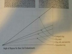
Or the critical angle of repose, of a granular material is the steepest angle of descent or dip relative to the horizontal plane to which a material can be piled without slumping. At this angle, the material on the slope face is on the verge of sliding. |
|
|
The Water Table |
Is the level beneath which the soil is saturated with groundwater. Some sites have seasonally fluctuating water tables. |
|
|
Topography |
The configuration of surface features of a plot of land. |
|
|
Contour Lines & Intervals |
Lines: imaginary lines joining points of equal elevation above a datum or bench mark Intervals: determined by the scale of the drawing, are the difference in elevation represented by any two adjacent contour lines on a topographic map or site plan. |
|
|
Ground Slopes & characteristics at 25%, 10%, 5-10% and up to 5%. |
Ground slope is a function of the total change in elevation and the horizontal distance. Over 25% - slopes are subject to erosion and are difficult to build on Over 10% - slopes are challenging to use for outdoor activities and are more expensive to build on. From 5 to 10% - slopes are suitable for informal outdoor activities and can be built on without much difficulty. Up to 5% - slopes are usable for most outdoor activities and are relatively easy to build on. |
|
|
What are the factors influencing the Microclimate of a site? |
Ground elevation Nature and orientation of landforms The presence of bodies of water |
|
|
What are the benefits of using plants on a site? |
Aesthetics, Conserving energy, Framing or screening views, Defining outdoor spaces, Improving air quality Moderating noise, Retarding erosion Visually connecting a building to its site. |
|
|
Altitude |
is the angular elevation of the sun above the horizon |
|
|
Azimuth |
is the angle of the horizontal deviation, measured clockwise, of a bearing from a standard south direction. |
|
|
Passive Solar Heating |
using solar energy to heat the interior space of a building without relying on mechanical devices that require additional energy. Passive solar systems rely on the natural heat transfer processed of conduction, convection and radiation for the collection, storage, distribution and control of solar energy. |
|
|
The Solar Constant |
is the average rate at which radiant energy form the sun is received by the earth, equal to 430 BTU per square foot per hour (1353 W/msquared/hour) |
|
|
What are the two essential elements in passive solar systems |
1. South-Facing glass or transparent plastic for solar collection 2. A thermal mass for heat collection, storage, and distribution, oriented to receive maximum solar exposure (Vents, dampers, movable insulation panels and shading devices can assist in balancing heat distribution) |
|
|
What are the three ways in which passive solar heating can be accomplished? |
Direct gain - collect heat directly within an interior space Indirect gain - control heat gain at the exterior skin of a building Isolated gain - collect and store solar radiation away from the space to be heated |
|
|
The quantity and quality of daylighting are determined by: |
The size and orientation of its window openings Transmittance of the glazing Reflectance of room surfaces and outdoor surfaces Obstructions of overhangs and nearby trees |
|
|
Name 3 of the 6 basic types of solar shading devices. |
Horizontal overhangs Horizontal Louvers Slanted Louvers Louvers hung from a solid overhang Vertical louvers Eggcrates Blinds and Drapes Trees |
|
|
Daylight diminishes as it penetrates interior space; generally what characteristics will allow more daylight to enter a room? |
The size and height of a window. Generally the large and higher the window the more daylight it allows into a room. General rule of thumb, daylighting can be effected for task illumination up to a depth twice the height of a window. |
|
|
What should you avoid when trying to design for daylighting in a space? |
Large areas of shiny surfaces. Daylight penetration from only one direction. Dark coloured surfaces (particularly on the ceiling and back-wall of a space) |
|
|
What factors will annual precipitation influence in a building design? |
Design and construction of the roof structure. Choice of building materials. Detailing of the exterior wall assemblies (Also, Building & Site drainage. eg flat roofs require interior roof drains or scuppers along perimeter) |
|
|
What are the two basic types of site drainage? |
Subsurface - underground network of piping for conveying groundwater to a point of disposal Surface - the grading and surfacing of a site in order to divert rain and other surface water into natural drainage patterns or into a storm sewer system |
|
|
What are the recommended surface drainage slopes for Grass lawns/Fields, and Paved parking areas? |
Grass Lawns and Fields - 1.5 - 10% Paved Parking Areas - 2 to 3% |
|
|
Swale |
is a shallow depression formed by the intersection of two ground slopes, designed to direct or divert the runoff of surface water. |
|
|
Dry Well |
is a drainage pit lined with gravel or rubble to receive surface water and allow it to percolate away to absorbent earth underground. |
|
|
Catch Basin |
is a receptacle for the runoff of surface water. They have a basin or sump that retains heavy sediment before it can pass into an underground drainpipe. |
|
|
Culvert |
is a drain or channel passing under a road or walkway |
|
|
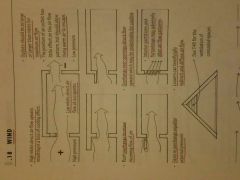
Seasonal and daily variations in wind should be carefully considered in evaluating its potential for... |
Ventilation Causing heat loss Imposing lateral loads on the building structure (Also, wind-induced overturning, uplift and sliding of building structure, components and cladding) |
|
|
What are the benefits of natural ventilation? |
Benefits for convective or evaporative cooling Reduced energy consumption by mechanical equipment and fans |
|
|
Wind exerts positive pressure on the windward surface of a building and a negative pressure (suction) on the sides and leeward surfaces. Name some of the characteristics of a particular building outlet(opening) and its effect on airflow. |
|
|
|
What is the first consideration to reduce the impact of exterior noise? |
Distance - locating a building as far from the noise source as possible (based on the principle that sound energy lessens in intensity as it disperses over a wide area) |
|
|
What are general characteristics of North, south and East-West Facing windows? Note: answer is work in progress |
North - exposed to winter winds in cool climates South - can be effectively shaded while admitting daylight. Ideal for passive solar design. East-West - are sources of overheating and are difficult to shade effectively |
|
|
What are the main purposes of Zoning Ordinances |
Manage growth, Regulate land-use patterns, Control building density, Direct development to areas with adequate services and amenities, Protect environmental sensitive areas, Conserve open space. |
|
|
What are some of the constraints to a building and/or site Zoning Ordinances may impose? |
Percentage of allowable land/lot cover. Percentage of allowable floor area Percentage of allowable width and depth Height Size and Shape (indirectly through minimum required distances to property lines, easements , rights of way, streets etc) |
|
|
Easement |
is a legal right held by one party to make limited use of the land of another, as for right of way or for access to light and air |
|
|
Right-of-Way |
is a legal right granted to a single party or the public to traverse another's land, as for access or the construction and maintenance of utility lines. |
|
|
What statutes does a Building Code establish the relationship between (possible rephrase: What general rules does a building code establish for a building)? |
The type of occupancy The fire resistance rating of its structure and construction The allowable height and floor areas of a building A buildings allowable separation from neighbouring structures |
|
|
Name 5 fundamental criteria for estimating and laying out site access and circulation. |
- Safe and Convenient Pedestrian access - Parking Requirements - Accessibility requirements (parking, curbs etc) - Public Loading Zones - Private Loading Zones - Emergency access - Curb cut requirements - Clear sight lines for vehicular traffic - Landscaping - Drainage - Snow removal equipment in cold climates |
|
|
Loading Berth |
A space for an automotive vehicle at rest. Typically 3 to 3.7m wide and 10.7 to 15.2m long |
|
|
What can be done to increase the stability of slopes subject to erosion? |
Diverting the runoff of surface water at the top of the slope, or by creating a series of terraces to reduce the velocity of the runoff. |
|
|
Revetment |
is a sloping structure placed on banks or cliffs in such a way as to absorb the energy of incoming water. |
|
|
Riprap |
rock or other material used to armour shorelines, stream-beds and bridge abutments, piling and other shoreline structures against scour and water or ice erosion. |
|
|
What is the principle means of protecting an embankment ? |
a revetment of riprap or gabions. often used with a filter fabric for drainage. (a natural means of stabilization include soil binders AKA plant material that inhibit or prevent erosion by providing ground cover and forming a dense network of roots that bind the soil) |
|
|
Gabions |
is a cage, cylinder, or box filled with rocks, concrete, or sometimes sand and soil for use in civil engineering, road building, military applications and landscaping. For erosion control, caged riprap is used.
|
|
|
When a desired change in ground elevation exceeds the angel of repose in a soil what device is necessary to hold back the mass of earth on the uphill side of the grade change? |
A retaining wall... designed to resist the lateral pressure of the soil being retained |
|
|
Name a some of the methods used to prevent a retaining wall from failing by overturning, horizontal sliding or excessive settling. |
Overturning - the resisting moment of the composite weight of the wall and any soil bearing on the heel of the base must counter the overturning moment created by soil pressure. Sliding - the composite weight of the wall times the coefficient of friction for the soil supporting the wall must counter the lateral thrust on the wall. The passive pressure of the soil abutting the lower level of the wall aids in resisting the lateral thrust. a key also increases resistance of the wall to sliding Settling - the vertical force must not exceed the bearing capacity of the soil, where the weight of the wall and any soil bering on the base plus the vertical component of the soil thrust for a wall with surcharge. |
|
|
Name 2 types of retaining walls |
Gravity wall - resists overturning and sliding by the sheer weight and volume of its mass (generally for structures less than 3m high) T-type Cantilevered wall - are used for retaining walls up to 6m high Counterfort Wall - uses triangular-shaped cross walls to stiffen the vertical slab and add weight to the base. counterforts are spaced at regular intervals equal to 1/2 the wall height L-type- used when the wall abuts a property line or other obstruction |
|
|
Deadman |
is a timber stone or concrete mass buried in the ground as an anchor. generally used for walls over 900mm high and placed 6' o.c. |
|
|
The bottom of stone/brick/concrete retaining walls should extend below what line? |
the frost line, or 610mm below the lower grade level, whichever is greater. |
|
|
Pavement receives the traffic ware, protects the base, and transfers its load to the base structure. Name the two general categories of pavement. |
Flexible - consisting of unit pavers (conc, brick or stone) laid on a sand setting bed, are somewhat resilient and distribute loads to the subgrade in a radiating manner. They require edging to restrain the horizontal movement of the paving material. Rigid- such as reinforced concrete slabs or paving units mortared over a concrete slav, distribute their loads internally and transfer them to the subgrade over a broad area. they require reinforcement and an extension of the base material along their edges. |
|
|
Base (pavement) |
is a foundation of well-graded aggregate that transfers the pavement load to the subgrade and prevents the upward migration of capillary water. |
|
|
Subgrade (pavement) |
should be undisturbed soil or compact fill. Should be sloped to drain. (away from the building) |
|
|
The Site Plan illustrates the existing natural and built features of a site and describes proposed construction in relation to these existing features. Usually based on an engineers land survey, the site plan is an essential piece of a set of construction documents. Name 10 items a completed site plan should include. |
1. Name and address of property owner 2. Address of property if difference from the owner's 3. Legal description of property 4. Source and date of land survey 5. Description of the site boundaries; dimensions of property lines, their bearing relative to north, angles of corners, and radii of curves. 6. Contract or project limits, if different from site boundaries 7. North arrow and scale of drawing 8. Location and description of bench marks, which establish the reference points f the location and elevations of new construction 9. Identification and dimensions of adjacent streets, alleys and other public rights-of-way 10. Location and dimensions of any easements or rights-of-way that cross the site. 11. Dimensions of setbacks required by the Zoning ordinance 12. Location and size of existing structures and a description of any demolition required by the new construction. 13. Location, shape and size of structures proposed for construction, including roof overhangs and other projections. 14. Location and dimensions of existing and proposed paved surfaces. (walkways, drives, parking etc ) 15. Location of existing utilities; water pains, sanitary and storm sewers, gas lines, electrical power lines, telephone and cable lines, fire hydrants, as well as proposed points of connections. 16. Existing contour lines, new contour lines and the finish grades of drives, walks, lawns, or other improved surfaces after completion of construction or grading. 17. Existing plant materials to remain and those to be removed 18. Existing water features 19. Proposed landscaping features such as: fencing, retaining walls, plantings (if extensive landscaping can be shown on another plan) 20. References to related drawings and details. |
|
|
What does a Metes-and-bounds survey call out: |
the course and length of each boundary line of a parcel of land, starting at a known reference point and working around the periphery of the plat until returning to the place of beginning |
|
|
A Survey Plat |
Is a legal document describing the location, boundaries, and dimensions of a tract or parcel of land, including zoning and planning commission approvals, easements and restrictions (and for a subdivision the dividing lines of streets, blocks and lots and the numbering and dimensions of each lot.) |
|
|
What is the average angle of repose for most soils? |
33 degrees |