![]()
![]()
![]()
Use LEFT and RIGHT arrow keys to navigate between flashcards;
Use UP and DOWN arrow keys to flip the card;
H to show hint;
A reads text to speech;
76 Cards in this Set
- Front
- Back
|
Lapse rate |
Temperature decreases with elevation Average lapse rate – cooling at rate of 6.4°C/km Lapse rate varies with water content in air |
|
|
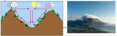
Saturated Adiabatic Lapse Rate (SALR ) |
Dew forms when the temperature drops to the point where water is condensing out of the air. Condensation releases energy (think of the opposite of evaporation) As a parcel of air rises, the (actual) temperature drops and water is condensed/precipitated. SALR varies with temperature from 4 oC/ km to9 oC/ km |
|
|
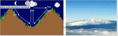
Atmospheric pressure |
~90% of atmosphere’s mass is within 15 km of the surface the Troposphere Basically– atmosphere is heavy and greatest “pressure” is closest to ground |
|
|
IdealGas Law |
PV = nRT P is the pressure (Pa) V is the volume in (m3) n is the number of moles (mol) 1 mole = 6.022×10²³molecules R is the gas constant 8.314 (J·K−1·mol−1) T is the temperature (K) |
|
|
Vertical and horizontal air movement |
|
|
|
How are low and high atmospheric pressure created at the surface |
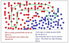
One column warms Air rises leading to lower density Lower atmospheric pressure – at surface The other column cools Air sinks leading to higher density Higher atmospheric pressure – at surface |
|
|
Air movement |
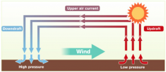
Related to differences in air pressure Wind is the horizontal movement of air from high pressure to low pressure Greater the difference = faster the wind |
|
|
Pressure gradient |
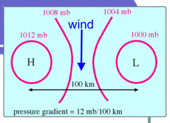
Change in pressure measured across a given distance lPG = change in pressure / distance The pressure gradient results in a net force that is directed from high to low pressure and this force is called the pressure gradient force. Wind is perpendicular to pressure gradiant |
|
|
Surface pressure chart and pressure gradient isograds (isobars) (How to see if winds are strong on a map !) |
The closer the isobars, the greater the PGF magnitude. Larger PGF result in stronger winds, so strong winds are associated with closely spaced contour lines. |
|
|
Reasons for pressure variation |
. Pressure differences are ‘forced’ by uneven absorption of solar radiation at the Earth's surface remember Ideal Gas Law: PV = nRT warmer air is less dense and typically exerts less pressure than cooler air however, for a given surface pressure, a column of cold air will decrease in pressure with height more rapidly than will a warm column of air . Moisture content of air also affects pressure The greater the amount of water vapour, the less dense the air will be, and the less pressure it will exert . Wind develops as a result of spatial (i.e. horizontal) differences in atmospheric pressure. Wind speed tends to be at their greatest during the daytime when the greatest spatial extremes in atmospheric temperature and pressure exist. |
|
|
GlobalEnergy Budget |
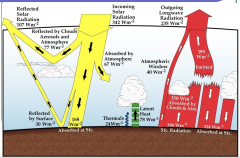
Global energy budget is determined by the balance between: - Solar energy absorbed by Earth - Infrared radiation emitted to space Neither is distributed uniformly Incoming solar radiation varies with latitude and season Outgoing radiation depends on temperature of the surface/atmosphere at a particular location |
|
|
Surface area of incoming solar radiation |
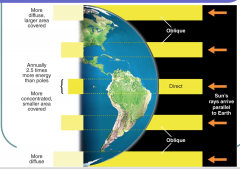
Sun's rays arrive parallel to Earth. They are direct at the equator and oblique at higher or lower latitudes. The equator receives 2.5 times more energy than the poles (More energy received in a smaller area, more concentrated) It is more diffused at the poles since the same amount of energy (heat from the sun) covers a larger area due to the obliquity. |
|
|
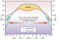
Average distribution of absorbed solar and emitted infrared radiation with latitude |
|
|
|
Global energy distribution - what creates circulation |
Distribution of global energy budget is a permanent feature of the system If there was no atmosphere = tropics would get warmer while poles get cooler The latitudinal energy gradient creates atmospheric temperature and density differences forcing the atmosphere to circulate carrying warm air to poles and colder air towards tropics |
|
|
General circulation of the atmosphere |
Heat surplus in the tropics Air warms and rises via convection This creates a low pressure region As air rises it must be replaced by horizontally moving air from higher pressure regions This is known as convergence The converging air masses that meet in the tropics are termed the intertropical convergence zone (ITCZ) |
|
|
ITCZ (intertropical convergence zone) |
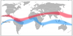
Surface heating in tropics also results in evaporation As convecting air rises, it cools, and the evaporated water (water vapour) condenses to form clouds ITCZ is therefore characterised by extensive cloud cover and heavy rainfall As winds come from northern and southern hemisphere they mix to create theso-called “doldrums” erratic weather patterns with stagnant calms and violent thunderstorms |
|
|
Generalcirculation of the atmosphere |
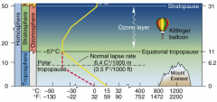
Stratosphere warmer than Troposphere - Troposphere warmed from below (Energy absorption, turbulence, convections etc) - Stratosphere warmed from above (heat comes mainly from ultra violet light interacting with ozone molecules) As air rises in troposphere it cools Stratosphere acts a cap to stop further rising |
|
|
General circulation of the atmosphere 2. |
Top of Troposphere: 10-15 kms This barrier forces uplifting air to diverge outward away from convective zone At ~30oN and ~ 30oS, the air subsides to replace the surface air moving towards equator The air warms as it sinks preventing condensation and cloud formation These regions of atmospheric subsidence are characterised by higher surface pressure, clear skies, low rainfall amounts (i.e. the desert regions) |
|
|
Hadley Cell Circulation |
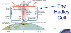
Low pressure at the surface at the equator. Hot, wet air. Air rises by convection. It rises, expands and cools. Creating high pressure at higher altitude. Some heat radiates to space. The air flows towards low-pressure area. It becomes cool and dry and thus subsides, condenses and warms to the subtropical high-pressure area.
Repeat |
|
|
What happens at 30-90° latitudes |
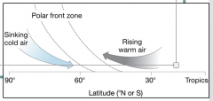
Low temperatures at the poles (esp. winter) Increased density of air near surface due to subsidence Higher pressures than at the tropics This leads to divergence and a general horizontal movement of cool air towards the equator This cool air will meet the warmer air coming from the tropics This contact zone produces a steep temperature gradient called the Polar Front These air masses do not mix well Warm air less dense Rises above cool air from poles Polar front slopes poleward with elevation |
|
|
The Ferrel cell |
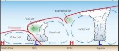
Subsidenceat ~30 degrees Upliftat ~60 degrees Inevitably, this leads to another cell: Ferrel |
|
|
The Coriolis Effect |
The tendency for a fluid (air or water) moving across the Earth’s surface to be deflected from its straight-line path due to the rotation of the Earth There are two aspects to the Coriolis effect that we must understand - Coriolis Force (affects winds going vertically N-S) - Centrifugal Force (affects winds going horizontally E-W) |
|
|
The Coriolis Force |
- Viewed from Earth in northern hemisphere A north-to-south moving object appears to be deflected to the west To the east for south-to-north – always to right in NH - Viewed from Space Same object will be seen to be moving in a straight line |
|
|
The Centrifugal force |
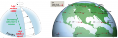
Whenair is moving eastwards or westwards, the Coriolis effect still comes intoplay, but for a different reason Centrifugalforce willpush the object (air) away from the centre of rotation If anair mass is moving eastwards faster than the Earth is rotating at thatlatitude, the air mass will be diverted away from the spin axis of the Earth |
|
|
High - Low Pressure systems & Coriolis effect |
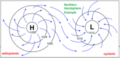
High - Low pressure systems : Air moves outwards from high pressure areas Air moves inwards towards low pressure areas Coriolis Effect : Both aspects of the Coriolis Effect deflects the wind and causes circulation around these systems |
|
|
Geostrophic wind
|
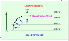
A parcel of air will accelerate from high pressure to low pressure because depending on the pressure gradient force (PGF). As the air parcel begins to move, it is deflected by the Coriolis Effect (to the right in the northern hemisphere, to the left in the southern hemisphere). Coriolis Effect always acts at 90° to the wind motion. As the wind gains speed, the deflection increases until the Coriolis Effect equals the pressure gradient force. This balance is called geostrophic balance. The geostrophic wind blows parallel to contours. / Actual wind can cross isobars |
|
|
Friction |
The surface of the Earth exerts a frictional drag on the air blowing just above it. This friction can act to change the wind's direction and slows it down The difference in terrain conditions directly affects how much friction is exerted. For example, a calm ocean surface is pretty smooth, so the wind blowing over it does not move up, down, and around any features. By contrast, hills and forests force the wind to slow down and/or change direction much more. |
|
|
How friction affects wind direction |
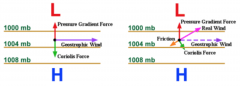
Geostrophic wind: case where pressure gradient force is equally and oppositely balanced by coriolis effect. |
|
|
Important elements & cells and problems with this model |
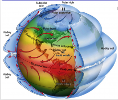
Important Elements: Hadley cell Ferrel cell Polar cell Polar easterlies Polar Front Westerlies Trade winds Doldrums Problems with it : - still too simplistic - As stated, friction is an important factor which means that this model is disrupted by the presence of land - The convective properties of rising air is also different between land and sea |
|
|
Meridional (North ↔ South) Circulations |
Hadley cell
|
|
|
Zonal(East ↔ West) Circulations |
Tradewind Walkercirculation Jets streams |
|
|
WalkerCirculation |
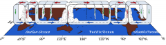
Longitudinally the Earth is not homogenous. Differences cause a variation in the circulation longitudinally Warm air rises over land (and warm seas). Below shows the Walker circulation. This circulation is in addition to the general Easterly equatorial flow (i.e. it is superimposed). |
|
|
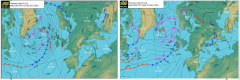
How do jetStreams form? |
![In the upper troposphere:
-Large pressure gradient from tropics towards poles
-Greatest wind speed when pressure gradient is steepest
-South (high) to north (low) pressure gradient – wind to north [in northern hemisphere]
-Influenced by co...](https://images.cram.com/images/upload-flashcards/68/12/77/17681277_m.png)
In the upper troposphere: -Large pressure gradient from tropics towards poles -Greatest wind speed when pressure gradient is steepest -South (high) to north (low) pressure gradient – wind to north [in northern hemisphere] -Influenced by coriolis effect so wind deflect to right (in NH) – eastwards. As there is no friction in upper troposphere, wind is geostrophic
However, these upper level winds move in a wavelike trajectory around the globe - known as Rossby waves |
|
|
Rossbywaves |
Theundulating motion of the Rossbywaves, coupled with the migratory pressure systems and storms associated withthe westerlies, give the middle latitudes more short-termweathervariability than any other place on Earth |
|
|
What are the two jet streams |
There are two cores of high-speed winds at high altitudes in the westerlies: - Polar front jet stream - Subtropical front jet stream Polar Jet stronger than subtropical jet |
|
|
Characteristics of jet streams |
- are typically thousands of kilometres long, a few hundred kilometres wide, and only a few kilometres thick -usually found somewhere between 10-15 km above the earth's surface - position of this upper-level jet stream denotes the location of the strongest SURFACE temperature contrast - Speeds in the Jet Steams extremely fast (>200 kph) -Huge influence on our weather |
|
|
Seasonalimplications on variability and strength of atmospheric circulation |
Thehemisphere experiencing summer has less of a temperature gradient between thetropics and the poles Basicallylarger distance between the ITZC and poles Thisweakens the strength of the atmospheric circulation Oppositeis true for the winter |
|
|
Local wind circulation - sea shore |
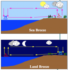
During day, land and ocean heat up differently By afternoon, land is warmer than ocean as it has a lower thermal heat capacity Warm air rises creating low pressure A local pressure gradient sets up and air moves from H to L, resulting in a sea breeze At night, land cools down faster than ocean, reversing the pressure gradient Wind blows off shore, resulting in land breeze |
|
|
Local wind circulation - Valley winds or breezes |
During the day the air close to the mountain sides becomes warmer than the surrounding air, thus lowering pressure relative to the cooler air at the same height over the valley. This warm air rises up the mountains and is replaced by air from within the valley. So during the day valley air moves up the mountain sides. This process leads to clouds and rain in the mountains in the summer, particularly in the late afternoon |
|
|
Local wind circulation - Mountain winds or breezes |
At night the sides of the mountain cool down and cool air is pulled down by gravity. In the morning, the coldest air is, therefore, often found within the valley – capped with valley cloud related to a temperature inversion |
|
|
Local wind circulation - Moutain ranges |
Whenair encounters mountain ranges, it rises, cools, and drops moisture on thewindward slopes resulting in a precipitation distribution called a rainshadow wherethe leeward slopes are dry. |
|
|
Local wind circulation - ColdFronts |
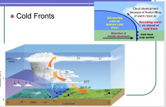
Cloud development because of frontal lifting of warm moist air |
|
|
Local wind circulation - WarmFront |
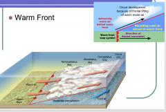
Cloud development because of frontal lifting of warm moist air |
|
|
Local wind circulation - OccludedFront |
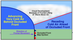
When a cold front overtakes a warm front, clouds develop because of frontal lifting of warm moist air |
|
|
Whatis ENSO? |
ENSOis a “coupled” phenomenon: atmospheredrives the ocean and the ocean drives the atmosphere An irregularlyperiodical variation in winds and sea surface temperatures over the tropicaleastern Pacific Ocean, affecting much of the tropics and subtropics Thereare two phases to ENSO: - Warm:El Niño - Cool:La Niña ENSOis pseudo-cyclic on a 2–7 (3-4) year time-scale - ElNiño –last 12-18 months - La Niña– last from 1-3 years Theextremes of this climate pattern's oscillations cause extreme weather (such asfloods and droughts) in many regions of the world |
|
|
La Niña |
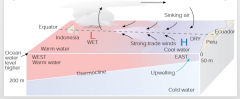
Cool phase Strongeasterly winds induce upwelling of cold water in the equatorial eastern Pacific Shallowoceanicthermocline in the east Pacific (due to upwelling) Warm SSTsconfined to western Pacific with a deep thermocline Low pressureand convection in west Pacific High pressureand subsidence (clear air) in east Pacific |
|
|
El Niño |
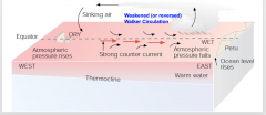
Warm phase Weaker easterly winds result in less upwelling of cold water Warm SSTs “spread” to east Pacific (also solar heating not offset by upwelling) Increase in the east Pacific thermocline Low pressure and convection shifts to the east Pacific High pressure and subsidence shifts to the west Pacific |
|
|
Atmosphere
|
The envelope of gases surrounding the earth. Is Layered.
|
|
|
Troposphere
|
The lowest region of the atmosphere, extending from earths surface to a height of approx 6–10km. Where weather and climate occur. The atmosphere is heavy and greatest pressure when closest to ground
|
|
|
Saturated Adiabatic Lapse Rate SALR
|
Rate at which atmospheric temp decreases with an increase in altitude.
|
|
|
Condensation
|
The conversion of vapor or gas to liquid. Water which collects as droplets on a cold surface when humid air is in contact with it. Releases energy ( think of opposite of evaporation)
|
|
|
Ideal Gas Law
|
PV = nRT
P= pressure V= volume T= Temp n= number of moles R= gas constant |
|
|
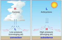
Cyclone
|
system of winds rotating inwards to an area of low pressure. Associated with bad weather.
|
|
|
Anticyclone
|
Weather system with high pressure at its centre. Associated with calm, fine weather.
|
|
|
Convection
|
System of winds converging on area of low pressure which rises to an area of high pressure causing a cyclone.
|
|
|
Subsidence
|
Anticyclone, wind at altitude at low pressure subsides, goes down, and diverges at surface where there is High pressure.
|
|
|
Pressure Gradient
|
Pressure gradient = change in pressure/distance
|
|
|
PGF
|
PG results in a net force that is directed from high to low pressure. The closer the isobars, the greater the PGF. Larger PGF results in stronger winds, so strong winds are associated with closely spaced contour lines.
|
|
|
seasonality
|
variations of solar radiation with latitude and season.
|
|
|
Intertropical Convergence Zone ITCZ
|
heat surplus in tropics. Air warms and rises via convection. this creates a low pressure region in which the air that rises must be replaced by horizontally moving air from higher pressure regions (convergence). these converging air masses that meet in the tropics are the ITCZ. characterized by extensive cloud cover and heavy rainfall.
|
|
|
Polar front
|
Low temp at poles. Increased density of air near surface due to subsidence. higher pressures than at the tropics. This leads to divergence and a general horizontal movement of cool air towards the equator. This cool air meets the warmer air coming from the tropics. this contact zone produces a steep temp gradient called the polar front. These air masses do not mix well. Warm air less dense rises above cool air from poles.
|
|
|
Centrifugal force
|
will push the object (air) away from the center of rotation. Record player analogy with penny, stays on closer to middle, on sides falls off instantly. Decreasing deflection towards equator. Largest deflection at poles
|
|
|
Walker Circulation
|
Longitudinal circulation. The Walker circulation is seen at the surface as easterly trade winds which move water and air warmed by the sun towards the west. The western side of the equatorial Pacific is characterized by warm, wet low pressure weather as the collected moisture is dumped in the form of typhoons and thunderstorms.
|
|
|
Rossby Waves
|
as there is no friction in upper troposphere, wind is geostrophic. However, these upper level winds move in a wavelike trajectory around the globe known as Rossby Waves.
|
|
|
Sea Breeze
|
by afternoon, land is warmer than ocean as it has a lower thermal heat capacity. Warm air rises creating low pressure. A local pressure gradient sets up and air moves from H to L.
|
|
|
Land Breeze
|
At night, land cools faster than the ocean and creates a pressure gradient. cool wind blows off of the high pressure shore onto the low pressure sea where it warms and rises.
|
|
|
Orogenic effects on air
|
when air meets mountain ranges, it rises , cools and drops moisture on the windward slope resulting in precipitation distribution called a rain shadow where the leeward slopes are dry
|
|
|
Cold Front
|
advancing mass of cool air which forces warm air up causing clouds due to front lifting of warm, moist air.
|
|
|
Warm Front
|
advancing warm mass of air lifts up over receding cold air causing clouds to form from lifting of warm, moist air.
|
|
|
Occluded Front
|
when a cold front overtakes a warm front
|
|
|
El Nino Southern Oscillation ENSO
|
an irregularly periodical variation in winds and sea surface temperatures over the tropical eastern Pacific Ocean, affecting much of the tropics and subtropics.
|
|
|
La Nina Cool phase
|
Strong Easterly winds induce upwelling of cold water in the equatorial eastern Pacific. Shallow oceanic thermocline in the East Pacific (due to upwelling). Warm sea surface temp confined to Western Pacific with a deep thermocline. Low pressure and convection in West, high pressure and subsidence in East Pacific. lasts from 1–3 years.
|
|
|
El Nino Warm phase
|
Weaker easterly winds result in less upwelling of cold water. Warm SSTs spead to East pacific ( also solar heating not offset by upwelling). Increase in East Pacific thermocline. Low pressure and convection shifts to east Pacific. High Subsidence and pressure shifts to West Pacific. Lasts from 12 to 18 months.
|
|
|
Global Energy Distribution
|
Determined by solar energy absorbed by earth and infrared radiation emitted to space. Outgoing radiation depends on temp of surface/atmosphere. variations in solar radiation due to latitude, higher lat suns rays are oblique, larger area to cover so more diffusion of energy whereas equator is direct, more concentrated, smaller area covered.
|
|
|
Water Vapours effect on pressure
|
Water vapour lighter than oxygen or nitrogen so the greater amount of water vapour, the less dense the air will be, and the less pressure it will exert.
|
|
|
Due to seasonality, why do the tropics not get warmer and the poles get colder?
|
Would be the case without atmosphere. The latitudinal energy gradient creates atmospheric temperature and density differences forcing the atmosphere to circulate carrying warm air to poles and colder air towards tropics.
|