Reading...
![]()
Play button
![]()
Play button
![]()
Use LEFT and RIGHT arrow keys to navigate between flashcards;
Use UP and DOWN arrow keys to flip the card;
H to show hint;
A reads text to speech;
105 Cards in this Set
- Front
- Back
|
Coastal Processes and Terrains
|
The coastal environment is usually dynamic, often showing changes in appearance and process from day to day or even hour to hour.
Part of this dynamism is a consequence of shorelines acting as an interface of the lithosphere, hydrosphere, and atmosphere—and quite often the cryosphere and biosphere as well. |
|
|
Coastal Processes and Terrains
|
bodies of water—especially the oceans—are important components of a number of key Earth systems.
In addition to the ocean’s role of regulating the temperature of Earth, some of the energy received from the Sun ultimately powers wind that creates currents and waves that, as we will see in this chapter, can in turn shape coastal landforms. |
|
|
The Impact of Waves and Currents on the Landscape (LS)
|
• Coastal processes affect a tiny portion of Earth’s landscape
• Waves as agents of erosion • Currents as agents of transportation and deposition • Beaches mark transition between land and water and are highly variable |
|
|
The Impact of Waves and Currents on the Landscape
|
Generally along shorelines, waves are agents of erosion, and currents are agents of transportation and deposition.
The most notable land features created by wave erosion are rocky cliffs and headlands. Depositional features along coastlines are diverse in form, but by far the most common are beaches and sandbars. Beaches along the shorelines of both oceans and lakes mark a transition from land to water, and are usually impermanent features of the landscape (highly variable) Beaches build up during times of “normal” weather and erode or completely disappear during storms. |
|
|
Coastal Processes (LS)
|
• Interface of three major components of Earth’s environment
• Highly energetic due to constant motion of waters • Importance of wind |
|
|
Coastlines are an Interface of three major components of Earth’s environment:
|
A coastline is the place where hydrosphere, lithosphere, and atmosphere meet. It is often an interface of ceaseless movement and energy transfer. Pounding waves do not always erode evenly and smoothly.
|
|
|
Coastlines?
|
Coastlines are a dynamic and highly energetic environment, primarily because of the restless motions of the waters
|
|
|
Ocean and lake formations similar except for which three (3) aspects?
|
Ocean and lake formations similar except for:
– Range of tides is smaller for lakes than oceans – Water level change differences (causes of sea-level fluctuations between the ocean and lakes) – Reefs only in oceanic water (Coral reefs are built only in tropical and subtropical oceans, not in lakes.) |
|
|
The Role of Wind in Coastal Processes
|
wind can be an important shaper of landforms, particularly through the deposition of sand.
Along coastlines, the wind has an even greater influence on topography it is primarily wind blowing over the surface of a body of water that generates waves and ocean currents. The wind as well as other things causes water movement. Oceanic coastlines also experience daily tidal fluctuations that often move enormous quantities of water. Tectonic events, particularly earthquakes, contribute to water motion, as does volcanic activity upon occasion. Even more fundamental are long-term variations in sea or lake level caused by tectonic forces and eustatic sea-level change (sea-level change due to an increase or decrease in the amount of water in the world ocean). |
|
|
Wind is the most important cause of water movement.
|
Wind is the most important cause of water movement.
|
|
|
Waves?
|
Waves entail the transfer of energy through a cyclical rising and falling motion in a substance.
Water waves, which are undulations in the surface layers of a water body. • Most are wind generated over oceans • Wind stress generated waves |
|
|
What is a Swell?
|
An ocean wave, usually produced by stormy conditions, that can travel enormous distances away from the source of the disturbance.
|
|
|
Waves of Oscillation
|
Waves that move in a circular or oscillatory fashion with little forward movement, waves of oscillation.
|
|
|
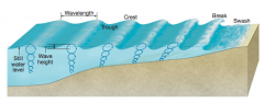
Wave Crest?
|
As the wave passes, the water moves upward, producing a wave crest
|
|
|
Wave Trough?
|
Then crest formation is followed by a sinking of the surface that creates a wave trough.
|
|
|
Wavelength?
|
The horizontal distance from crest to crest or from trough to trough is called the wavelength.
|
|
|
Wave Height?
|
The vertical dimension of wave development is determined by the circular orbit of the surface water as the wave form passes; the vertical distance from crest to trough is equivalent to the diameter of this orbit and is called the wave height.
The height of a wave depends on wind speed, wind duration, water depth, and fetch (the area of open water over which the wind blows). |
|

|
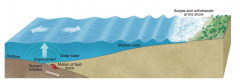
In deep water, the passage of a wave involves almost circular movements of the water. Water movement diminishes rapidly with increasing depth, as shown here by decreasing orbital diameter downward. As the wave moves into shallow water, the revolving orbits
of the water become more elliptical, the wavelength becomes shorter, and the wave becomes steeper. Eventually the wave “breaks” and dissipates its remaining energy as it washes up onto the beach. |
|
|
The passage of a wave of oscillation normally moves water only very slightly in the direction of flow.
|
The passage of a wave of oscillation normally moves water only very slightly in the direction of flow.
|
|
|
Thus when a wave passes through an object floating on the surface simply bobs up and down without advancing, except as it may be pushed by the wind.
|
Thus when a wave passes through an object floating on the surface simply bobs up and down without advancing, except as it may be pushed by the wind.
|
|
|
The influence of wave movement diminishes rapidly with depth; even very high waves stir the subsurface water to a depth of only a few tens of meters.
|
The influence of wave movement diminishes rapidly with depth; even very high waves stir the subsurface water to a depth of only a few tens of meters.
|
|
|
Waves often travel great distances across deep water with relatively little change in speed or shape. As they roll into shallow water, however, a significant metamorphosis occurs.
|
Waves often travel great distances across deep water with relatively little change in speed or shape. As they roll into shallow water, however, a significant metamorphosis occurs.
|
|
|
Waves of Translation?
|
Shallow water waves influenced by ocean floor, gain forward progress
When the water depth becomes equal to about half the wavelength, the wave motion begins to be affected by frictional drag on the sea bottom. The waves of oscillation then rapidly become changed into waves of translation, and the result is significant horizontal movement of the surface water. |
|

A Breaking Wave (Wave Break)
|
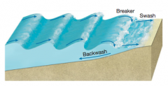
A breaking wave. In shallow water the ocean bottom impedes oscillation, causing the wave to become increasingly steeper until it is so oversteepened that it collapses and tumbles forward as a breaker. The surging water then rushes up the beach as swash, and then drains off the beach below the waves as backwash.
|
|
|
What is Swash?
|
When a wave breaks, the motion of the water instantly becomes turbulent, like that of a swift river. The breaking wave rushes toward shore or up the beach as swash. This surge can carry sand and rock particles onto the beach, or it can pound onto rocky headlands and sea cliffs with considerable force
|
|
|
What is Backwash?
|
The momentum of the surging swash is soon overcome by friction and gravity, and a return flow, called backwash, drains much of the water seaward again carrying loose material with it, usually to meet the oncoming swash of the next wave.
|
|
|
Wave Refraction. (LS)
|
– Change in wave direction as they approach shore
– Uneven coastline and irregular water depth – Waves bent due to uneven slowing of waves from irregular water depth – Wave action focused on headlands, much gentler in adjacent bay areas |
|
|
What is Wave Refraction?
|
The phenomenon where waves often change direction as they approach the shore
|
|
|
Wave Refraction Occurance?
|
It occurs when a line of waves does not approach exactly parallel to the shore, or where the coastline is
uneven or there are irregularities in water depth in the nearshore zone. |
|
|
Wave Refraction?
|
One portion of a wave reaches shallow water sooner than other portions and is thus slowed down. This slowing down causes the wave line to bend (refract) as it pivots toward the obstructing area, finally breaking roughly parallel to shore.
Thus, wave energy tends to be concentrated in the vicinity of an obstruction and diminished in other areas |
|
|
Refraction of waves
on an irregular coastline. |
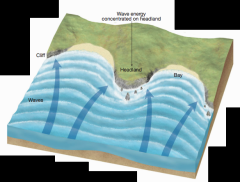
The waves reach the headland first and then “wrap” around it, breaking nearly parallel to the coastline as a result of wave refraction. Thus, wave energy is concentrated on the headlands and is diminished in the bays.
|
|
|
Wave Refraction?
|
The most conspicuous geomorphic result of wave refraction is the focusing of wave action on headlands, subjecting them to the direct onslaught of pounding waves, whereas an adjacent bay experiences much gentler, low-energy wave action.
|
|
|
Wave Erosion
|
– Consistent pounding of small waves results in erosion
– Large storms significantly enhance coastal erosion – Air forced into cracks in coastal rocks when water moves inland; air released as water recedes and enhances erosion – Chemical action of seawater – Notches cut in the bases of cliffs |
|

.
|
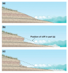
a) Waves pounding an exposed rocky shoreline erode the rock most effectively at water level, with the result that a notch may be cut in the face of the headland. (b) The presence of this notch undermines the higher portion of the headland, which may subsequently collapse, producing a steep cliff. (c) The notching/undercutting/collapse sequence may be repeated many times, causing the cliff face to retreat.
|
|
|
Tsunamis
|
– Waves triggered by disruptions in the ocean floor
– When fault rupture on an ocean floor generates a tsunami, the entire depth of ocean above rupture is displaced – Inconspicuous in open ocean with long wavelengths and low heights – Can travel over 400 mph – Significant withdrawal of up to 40 meters before a significant surge of water |
|
|
The formation of a tsunami
|
The formation of a tsunami. A vertical disruption of the ocean floor, such as from faulting, displaces the entire water column from the ocean floor to the surface. In the open ocean, the tsunami may be almost indistinguishable because of its great wavelength. Once it reaches shallow water, however, wave height increases and the tsunami comes onshore as a series of surges and withdrawals.
|
|
|
Important Shoreline Shaping Processes
|
??
|
|
|
• Tides
|
– Alterations of ocean level from gravitational pull of Sun and Moon
– Two high tides and two low tides per day – Topographic effects generally small – Significant agents of erosion only in narrow bays, around shallow seas, and in passages between islands |
|
|
Changes in Sea Level and Lake Level
|
Sea-level changes can result either from the uplift or sink- ing of a landmass (tectonic cause), or from an increase or decrease in the amount of water in the oceans—eustatic sea level rise
|
|
|
tectonic cause
|
Sea-level changes from the uplift or sinking of a landmass
|
|
|
eustatic sea-level change
|
Sea-level changes from an increase or decrease in the amount of water in the oceans
|
|
|
Global Warming and Sea-Level Change:
|
– Thermal expansion of water and melting of ice caps increasing water volume (eustatic)
– Sea level rise of up to 1 meter by the end of the century |
|
|
Ice Push
|
– Bodies of water that freeze in winter, resulting in expansion and subsequent contraction
– Ice pushes onto land, significantly modifying land surface, similar to small glacial advance – Most common in Arctic and Antarctic regions |
|
|
Organic Secretions
|
– Many aquatic animals form calcium carbonate shells
– Animals cluster together and form enormous masses of reefs, platforms, and atolls |
|
|
Stream Outflow
|
– Streams important sources of sediment to oceans and lakes
|
|
|
Currents and Coastal Sediment Transport
|
Many kinds of currents flow in the oceans and lakes of the world, but nearly all transportation of sediment along coastlines is accomplished by wave action and local currents.
|
|
|
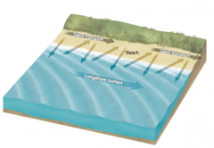
Longshore Currents
|
– Water moves parallel to shoreline (“along” shore)
– Develop just offshore and set up by waves striking coast at an angle – Wind direction reflected in longshore currents |
|
|
What are Longshore Currents?
|
Currents in which the water and sediment move roughly parallel to the shoreline. (Think of longshore as a contraction for “along the shore.”)
|
|
|
Beach Drifting:
|
– Short distance shifting of sand by breaking waves and retreating water
– Zigzag pattern of particle movement downwind and parallel to coast – Affects of tides on debris movement – Dune formation on coasts |
|
|
What is Beach Drifting?
|
The zigzag movement of sediment caused by waves washing particles onto a beach at a slight angle; the net result is the movement of sediment along the coast in a general downwind direction.
|
|
Beach Drifting
|

beach drifting involves a zigzag movement of sand along the coast. Sand is brought obliquely onto the beach by the wave and is then returned seaward by the backwash. Longshore currents develop just offshore and move sediment parallel to the coastline. Because most waves develop
in response to the wind, longshore currents and beach drifting typically move sediment in a general downwind direction along a shore. |
|
|
Coastal Depositional Landforms
|
– Results when energy of moving water is diminished
– Maritime deposits more ephemeral than noncoastal deposits due to composition and lack of vegetative cover – Sediment budget must be in balance to allow for deposit to persist |
|
|
Sediment Budget of Depositional
Landforms |
Maritime deposits along coastlines tend to be more ephemeral than noncoastal deposits. This is due primarily to the composition of marine deposits, which typically consist of relatively small particles (sand and gravel), and to the fact that the sand is not stabilized by a vegetation cover.
Consequently, the sediment budget must be in balance if the deposit is to persist; for the budget to be in balance, removal of sand must be offset by addition of sand. Most marine deposits have a continuing sediment flux, with debris arriving in some places and departing in others. During storms, the balance is often upset, with the result that the deposit is either significantly reshaped or totally removed, only to be replaced when calmer conditions prevail. |
|
Common Depositional Landforms
|

Common depositional landforms along a coastline include spits, baymouth bars, and tombolos. Note the orientation of the spit to to the direction of the longshore current.
|
|
|
• Beaches
|
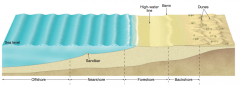
– Beaches relatively homogeneous
– Mark transition between land and ocean – Backshore contains berms; foreshore regularly covered and uncovered by tides – Offshore is zone that is permanently submerged |
|
|
What is backshore?
|
The backshore is the upper part of the beach, landward of the high-water line. It is usually dry, being covered by waves only during severe storms. It contains one or more berms,
|
|
|
What are berms?
|
flattish wave-deposited sediment platforms
|
|
|
What is the foreshore?
|
The foreshore is the zone that is regularly covered and uncovered by the rise and fall of tides.
|
|
|
What is the nearshore?
|
The nearshore extends from the low-tide mark, seaward to where the low-tide breakers begin to form—the nearshore is not exposed to the atmosphere, but it is the place where waves break and where surf action is greatest.
|
|
|
What is the offshore zone?
|
The offshore zone is permanently underwater and deep enough that wave action rarely influences the bottom.
|
|
|
Spits
|
– At mouth of a bay, sediment moved into deeper water
– Deposit attached to land at one end and extends to open ocean in downcurrent direction is a spit – Spits that extend across a bay, bay barriers or baymouth bars – Tombolos: waves converge on each side and deposit sand so the bar connects to land |
|
|
What is a Spit?
|
Any linear deposit attached to land at one end and extends to open ocean in downcurrent direction is a spit
|
|
|
What is a baymouth bar?
|
A spit that extends entirely across the mouth of a bay, transforming the bay into a lagoon.
In some cases, the spit becomes extended clear across the mouth of a bay to connect with land on the other side, producing what is called a baymouth bar and transforming the bay to a lagoon. |
|
|
What is a tombolo?
|
a depositional feature that connects a near-shore island with the mainland
(waves converge on each side and deposit sand so the bar connects to land) (LS) A spit formed by sand deposition that connects an island to the mainland. |
|
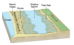
A typical relationship between ocean, barrier island, and lagoon.
|

A typical relationship between ocean, barrier island, and lagoon.
|
|
|
Barrier Islands
|
– Long, narrow sand bar built up in shallow offshore waters
– Oriented approximately parallel to shore – Only rise a few meters above sea level, but some extend to great lengths – Lagoon formation; mudflats |
|
|
What are Barrier Islands?
|
Long, narrow sand bars built up in shallow offshore waters
Oriented approximately parallel to shore They only rise a few meters above sea level, but some extend to great lengths |
|
|
What is a Lagoon?
|
An extensive barrier island isolates the water between itself and the mainland, forming a body of quiet salt or brackish water called a lagoon
A body of quiet salt or brackish water in an area between a barrier island or a barrier reef and the mainland. |
|
|
Life Cycle of a Lagoon?
|
Over time, a lagoon becomes increasingly filled with (1) water-deposited sediment from coastal streams, (2) wind-deposited sand from the barrier island, and (3) tidal deposits if the lagoon has an opening to the sea.
All three of these sources contribute to the buildup of mudflats on the edges of the lagoon. Unless tidal inlets across the barrier island permit vigorous tides or currents to carry lagoon debris seaward, the ultimate destiny of most lagoons is to be slowly transformed, first to mudflats and then to coastal marshes. |
|

??
|
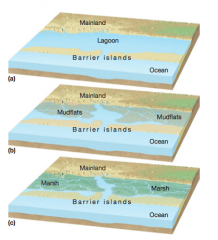
Barrier islands are separated from the mainland by lagoons (a). With the passage of time, the lagoons often become choked with sediment and become converted to mudflats (b) or marshes (c).
|
|
|
Human Modification of Coastal Sediment Budgets
|
– Dams act as sediment traps, allowing less sediment to reach oceans and resulting in shrinking beaches
– Use of groins to help impede the downcurrent flow of sediment – Jetties used to keep water moving and reduce sediment deposits in navigation channels |
|
|
What is a Groin?
|
A short wall built perpendicularly from the beach into the shore zone to interrupt the longshore current and trap sand.
|
|
|
What is a Jetty?
|
A wall built into the ocean at the entrance of a river or harbor to protect against sediment deposition, storm waves, and currents.
|
|

Jetties and groins along a shoreline trap sediment on their upcurrent side, while erosion tends to remove sediment on their downcurrent side.
|
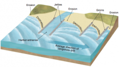
Jetties and groins along a shoreline trap sediment on their upcurrent side, while erosion tends to remove sediment on their downcurrent side.
|
|
|
Shorelines of Submergence
|
– Most oceanic coastline shows evidence of submergence at some time within last 15,000 years
– Ria Shorelines – Fjorded Coasts |
|
|
What is a Ria Shoreline?
|
A coast with numerous estuaries
An embayed coast with numerous estuaries; formed by the flooding of stream valleys by the sea (the submergence of shorelines results in drowning of previous river valleys) |
|
|
What are estuaries?
|
long fingers of seawater projecting inland
|
|
|
What is a Shoreline of Submergence?
|
a relative rise in sea level leading to a shoreline of submergence,
|
|
|
What is a Shoreline of Emergence?
|
a relative rise in the land leading to a shoreline of emergence
|
|
|
Fjorded Coasts
|
• Extensive glaciation gouges out troughs by glaciers or ice sheets
• Troughs far below sea level, eventually fill with sea water • Deep coastal indentations are called fjords • Create extraordinarily irregular coastlines |
|
|
What are Fjords?
|
A glacial trough that has been partly drowned by the sea.
|
|
|
Shorelines of Emergence and Erosion
|
– Shoreline features raised well above current sea level
|
|
|
Wave-Cut Cliffs and Platforms
|
– Constant pounding of waves at base of landforms cuts a notch at the high water level
– Broad erosional pattern called a wave-cut bench or wave-cut platform – Most cut debris shifted just beyond wave-cut bench to wave-built terrace |
|
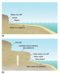
??
|

(a) A wave-cut platform develops where a coastal cliff is worn back by wave erosion. (b) A marine terrace develops when a wave-cut
platform is tectonically uplifted above sea level. |
|
|
What is a wave-cut platform?
|
Broad erosional pattern called a wave-cut bench or wave-cut platform
|
|
|
Marine Terraces
|
– Wave-cut platforms uplifted along tectonically rising coasts
– Several instances of marine terraces indicate several episodes of marine terrace formation – Can be used to deduce history of the water levels in a region |
|
|
What are Marine Terraces?
|
A platform formed by marine erosion that has been uplifted above sea level.
|
|
|
Coral Coasts
|
– Most continents and islands are fringed with coral reefs or another coralline structure
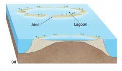
– Critical element is a group of anthozoan animals – Calcium carbonate skeletons from coral polyps – Have a blossom like appearance similar to plants – Have strict requirements for their survival – Fringing Reefs: those built right onto a volcano – Barrier Reefs: coral that appears to float around a volcano – Atolls |
|

Coral Reef Formation Around a Sinking Volcano: Fringing Reefs
|
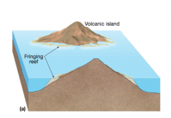
Coral reef formation around a sinking volcano. (a) Around a newly formed volcano rising above the water of a tropical ocean, secretions from coral polyps living along the shallow-water flanks of the volcano accumulate into a fringing reef attached to the mountain.
Fringing Reefs: those built right onto a volcano |
|

Coral Reef Formation Around a Sinking Volcano: Barrier Reefs
|
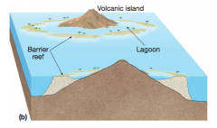
(b) As the volcano becomes dormant and begins to sink, the coral continues to grow upward over the original base, essentially a cylinder surrounding the mountain. Such a reef separated from its mainland by a lagoon is a barrier reef.
Barrier Reefs: coral that appears to float around a volcano |
|
Coral Reef Formation Around a Sinking Volcano: Atolls
|

(c) Once the volcano is completely submerged, the coral surrounding a landless lagoon is called an atoll reef.
|
|

Coral Reef Formation Around a Sinking Volcano
|
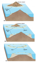
Coral reef formation around a sinking volcano:
(a) fringing reef (b) barrier reef (c) atoll reef. |
|
|
The most energetic coastal processes are observed by wave motions
|
The most energetic coastal processes are observed by wave motions
|
|
|
Tsunamis are significant dangerous waves that result from underwater earthquakes, not from winds
|
Tsunamis are significant dangerous waves that result from underwater earthquakes, not from winds
|
|
|
Tides play a small role in the sculpting of landforms of coasts
|
Tides play a small role in the sculpting of landforms of coasts
|
|
|
Numerous processes are involved that modify the lake level and sea level of bodies of water
|
Numerous processes are involved that modify the lake level and sea level of bodies of water
|
|
|
Many other coastal processes, including ice push, organic secretions, and stream outflow, help structure coastal landforms
|
Many other coastal processes, including ice push, organic secretions, and stream outflow, help structure coastal landforms
|
|
|
Currents are primarily responsible for the transport of coastal sediment
|
Currents are primarily responsible for the transport of coastal sediment
|
|
|
Coastal deposition takes place in areas where ocean water moves more slowly, and is typically ephemeral
|
Coastal deposition takes place in areas where ocean water moves more slowly, and is typically ephemeral
|
|
|
The most widespread coastal landform is called a beach
|
The most widespread coastal landform is called a beach
|
|
|
Spits and barrier islands result from deposition of sedimentary material by the longshore currents
|
Spits and barrier islands result from deposition of sedimentary material by the longshore currents
|
|
|
Lagoons result when barrier islands cut off one small region of ocean water from the remaining ocean
|
Lagoons result when barrier islands cut off one small region of ocean water from the remaining ocean
|
|
|
Humans have modified the structure of shorelines through damming and the building of groins and jetties
|
Humans have modified the structure of shorelines through damming and the building of groins and jetties
|
|
|
Shorelines can be divided into two categories, emergence or submergence
|
Shorelines can be divided into two categories, emergence or submergence
|
|
|
Coral coasts consist of organic material and typically surround volcanoes
|
Coral coasts consist of organic material and typically surround volcanoes
|