![]()
![]()
![]()
Use LEFT and RIGHT arrow keys to navigate between flashcards;
Use UP and DOWN arrow keys to flip the card;
H to show hint;
A reads text to speech;
37 Cards in this Set
- Front
- Back
- 3rd side (hint)
|
(Refer to Figure 27.) An aircraft departs an airport in the central standard time zone at 0845 CST for a 2-hour flight to an airport located in the mountain standard time zone. The landing should be at what coordinated universal time? |
1645Z |
|
|
|
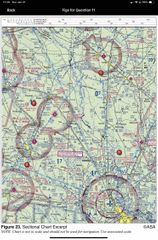
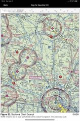
(Refer to Figure 23, area 3.) What is the floor of the Savannah Class C airspace at the shelf area (outer circle)? |
1300 feet MSL |
|
|
|
(Refer to Figure 22.) What is the magnetic heading for a flight from Priest River Airport (area 1) to Shoshone County Airport (area 3)? The wind is from 030° at 12 knots and the true airspeed is 95 knots. |
121 degrees |
|
|
|
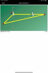
(Refer to Figure 68.) The line from point C to point A of the wind triangle represents |
Wind direction in velocity |
|
|
|
Airspace at an airport with a part-time control tower is classified as Class D airspace only |
When associated tower control is in operation |
|
|
|
What type military flight operations should a pilot expect along IR 644? |
IFR training flights above 1500 AGL, and excess of 250 kts |
|
|
|
Responsibility for collision avoidance in an alert area rests with |
All pilots |
|
|
|
A non-tower satellite airport, within the same Class D airspace as that designated for the primary airport, requires radio communications be established and maintained with the |
Airport primary control tower |
|
|
|
The vertical limit of Class C airspace above the primary airport is normally |
4000 feet AGL |
|
|
|
If a true heading of 135° results in a ground track of 130° and a true airspeed of 135 knots results in a groundspeed of 140 knots, the wind would be from |
246 degrees at 13 kts |
|
|
|
What minimum altitude is necessary to vertically clear the obstacle on the northeast side of Airpark East Airport by 500 feet? |
1273 feet MSL
The elevation of the top of the obstacle is shown as 773 feet MSL. Add the 500-foot vertical clearance specified by the question to the height (MSL) of the obstacle: 773 feet MSL + 500 = 1,273 feet MSL minimum altitude |
|
|
|
Determine the magnetic heading for a flight from Dallas Executive (area 3) to Fort Worth Meacham (area 4). The wind is from 030° at 10 knots, the true airspeed is 135 knots, and the magnetic variation is 7° east |
286 degrees |
|
|
|
(Refer to Figure 23, area 3.) The top of the group obstruction approximately 11 nautical miles from the Savannah VORTAC on the 009° radial is |
454 feet MSL |
|
|
|
(Refer to Figure 25.) Determine the magnetic heading for a flight from Fort Worth Meacham (area 4) to Denton Muni (area 1). The wind is from 330° at 25 knots, the true airspeed is 110 knots, and the magnetic variation is 7° east. |
004 degrees |
|
|
|
Under what condition may an aircraft operate from a satellite airport within Class C airspace? |
Pilot should contact ATC as soon as practical after takeoff |
|
|
|
(Refer to Figure 26, area 2.) What is the approximate latitude and longitude of Cooperstown Airport? |
47degree -25’ N and 98 degrees -06 W |
|
|
|
The airspace directly overlying the town of Findlay is |
Surface area class E airspace |
|
|
|
The airspace directly overlying the town of Findlay is |
4000 Ft MSL |
|
|
|
(Refer to figure 25, area 7.) The airspace overlying Collin Co RGL McKinney (TKI) is controlled from the surface to |
2900 ft MSL |
|
|
|
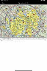
The radius of the procedural Outer Area of Class C airspace is normally |
20 NM |
|
|
|
(Refer to Figure 25, area 2.) The floor of Class B airspace at Addison Airport is |
3000 MSL
The thick blue lines on the sectional chart indicate the boundaries of the overlying Class B airspace. Within each segment, the floor and ceiling are denoted by one number over a second number or the letters SFC. The floor of the Class B airspace is 3,000 feet MSL. |
|
|
|
(Refer to Figure 23, area 3.) What is the height of the lighted obstacle approximately 6 nautical miles southwest of Savannah International? |
1548 ft MSL |
|
|
|
Which statement about longitude and latitude is true? |
Lines of longitude 90degrees at the equator |
|
|
|
(Refer to Figure 68.) The line from point C to point B of the wind triangle represents |
Groundspeed and true course |

|
|
|
How far will an aircraft travel in 2-1/2 minutes with a groundspeed of 98 knots? |
4.08 98 x 2.5/60=4.08 |
|
|
|
(Refer to Figure 22, area 3.) Determine the approximate latitude and longitude of Shoshone County Airport. |
47degrees-37’N and 116degrees11’W |
|
|
|
(Refer to Figure 22, area 3.) Determine the approximate latitude and longitude of Shoshone County Airport. |
47degrees-37’N and 116degrees11’W |
|
|
|
(Refer to Figure 25, area 4.) The airspace directly overlying Fort Worth Meacham is |
Class D to 3200 ft MSL |
|
|
|
Normal VFR operations in Class D airspace with an operating control tower require the ceiling and visibility to be at least |
1000 ft and 3 miles |
|
|
|
Determine the magnetic heading for a flight from Sandpoint Airport (area 1) to St. Maries Airport (area 4). The wind is from 215° at 25 knots and the true airspeed is 125 knots. |
172 degrees |
|
|
|
(Refer to figure 22.) Determine the magnetic heading for a flight from St. Maries Airport (area 4) to Priest River Airport (area 1). The wind is from 340° at 10 knots, and the true airspeed is 90 knots. |
329 degrees |
|
|
|
What minimum radio equipment is required to land and take off at Norfolk International? |
Mode C transponder and two way radio |
|
|
|
Determine the magnetic course from First Flight Airport (area 5) to Hampton Roads Airport |
332 degrees |
|
|
|
Determine the magnetic heading for a flight from Mercer County Regional Airport (area 3) to Minot International (area 1). The wind is from 330° at 25 knots, the true airspeed is 100 knots, and the magnetic variation is 10° east |
352 |
|
|
|
When converting from true course to magnetic heading, a pilot should |
Add Westerly variation and subtract left wind correction angle |
|
|
|
When a control tower, located on an airport within Class D airspace, ceases operation for the day, what happens to the airspace designation? |
Airspace reverse to class E airspace and class G when tower operations are closed |
|
|
|
The line from point A to point B of the wind triangle represents |
True, heading and airspeed |

|