Reading...
![]()
Play button
![]()
Play button
![]()
Use LEFT and RIGHT arrow keys to navigate between flashcards;
Use UP and DOWN arrow keys to flip the card;
H to show hint;
A reads text to speech;
46 Cards in this Set
- Front
- Back
|
A navigational position line is a part of a ......
(1) position circle. (2) small circle. (3) segment. (4) All of the other options. |
1
|
|
|
Distance on a chart is measured using ......
(1) latitude scale. (2) longitude scale. (3) any uniform scale. (4) none of the given options. |
1
|
|
|
How often are chart corrections published?
(1) Weekly (2) Monthly (3) Yearly (4) Annually |
1
|
|
|
How often is a chart catalogue published?
(1) Annually (2) Monthly (3) Twice a year (4) Weekly |
1
|
|
|
In what direction does the axis of the gyro-compass wheel point?
(1) True North (2) Magnetic North (3) North Relative (4) Compass North |
1
|
|
|
In which publication can information on ship reporting be found?
(1) ALRS (2) Ship Routeing (3) IAMSAR (4) SOPEP Manual |
1
|
|
|
In which publication can information on VTS be found?
(1) ALRS (2) Tide Tables (3) Routeing Charts (4) Chart Catalogues |
1
|
|
|
The best position fix is obtained when the bearings of two objects are......
(1) 90 degrees apart. (2) 45 degrees apart. (3) 180 degrees apart. (4) 135 degrees apart. |
1
|
|
|
The correct order to follow when planning a passage is ......
(1) appraise, plan, monitor, execute (2) plan, appraise, monitor, execute (3) plan, monitor, appraise, execute (4) plan, monitor, execute, appraise. |
1
|
|
|
The direction towards which a tidal stream runs is called ......
(1) set (2) drift (3) current (4) leeway |
1
|
|
|
The relationship between the distance on the earth and the length by which that distance is shown on the navigation chart is called the ......
(1) natural scale. (2) actual scale. (3) calculated scale. (4) variable scale. |
1
|
|
|
The vertical distance between the sea bed and the deepest part of the keel is known as the ......
(1) underkeel clearance. (2) draft. (3) depth. (4) sounding. |
1
|
|
|
Under soundings marked on the chart, the nature of the sea bottom is also indicated. What does Sh indicate?
(1) Shells (2) Corals (3) Soft mud (4) Shingle |
1
|
|
|
What are sailing directions also known as?
(1) Pilot books (2) Guide to port entry (3) Routeing charts (4) Passage planning charts |
1
|
|
|
What charts are used for coasting, pilotage waters and plotting waypoints?
(1) Large scale (2) Small scale (3) Routeing (4) Instructional |
1
|
|
|
What charts are used for plotting Great Circle courses?
(1) Gnomonic (2) Instructional (3) Routeing (4) Passage planning |
1
|
|
|
What is a routeing measure aimed at the separation of opposing streams of traffic by establishing traffic lanes called?
(1) Traffic separation scheme (2) Traffic Lane (3) Separation Zone (4) Recommended route |
1
|
|
|
What is the east - west distance between two points called?
(1) Departure (2) D'long (3) D'lat (4) DMP |
1
|
|
|
What is the line roughly following the 180th meridian called?
(1) The date line (2) The Greenwich meridian (3) The Equator (4) A rhumb line |
1
|
|
|
What is the meaning of the symbol Cl on a navigational chart?
(1) Clay (2) Coral (3) Cloud (4) Cill |
1
|
|
|
What is the vertical distance on a given day between the water surface at high and low water called?
(1) Range of tides (2) Height of tide (3) Highest astronomical tide (4) Lowest astronomical tide. |
1
|
|
|
When selecting the maximum distance at which a landfall light would be visible, which of the following should be selected?
(1) lesser of the two (geographical & nominal range) (2) geographical range (3) nominal range (4) greater of the two (geographical & nominal range) |
1
|
|
|
When using great circle sailing the saving in distance is the most when......
(1) the course is E-W ,nearer to the poles. (2) at the equator. (3) the course is N-S. (4) the course is one of the inter-cardinal headings. |
1
|
|
|
Where can you find the symbols and abbreviations used on the Admiralty charts?
(1) Chart 5011 (2) Chart 5022 (3) Chart catalogue (4) Notices to mariners |
1
|
|
|
Where is the title of the navigation chart printed?
(1) In some convenient, conspicuous place, where it does not hinder navigation or the use of it. (2) Always at the center of the chart. (3) Where the sea areas are located. (4) Always at the bottom left hand margin. |
1
|
|
|
Where will you find a comprehensive list of navigation charts with the title and number for various parts of the world?
(1) Chart catalogue (2) Chart 5011 (3) Chart folio (4) Sailing directions |
1
|
|
|
Who publishes the chart catalogue?
(1) Hydrographer to the Navy (2) IMO (3) ICS (4) HMSO |
1
|
|
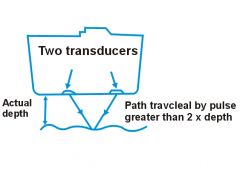
Which error in the echo sounder is illustrated in the diagram?
(1) Pythagoras (2) Multiple error (3) Velocity error (4) False bottom echoes |
1
|
|
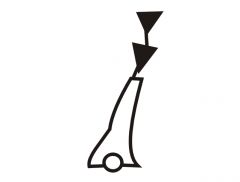
On a navigational chart, what does this figure indicate?
(1) Windmill (2) Wind-motor (3) Chimney (4) Pillar |
1
|
|
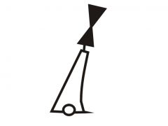
On a navigational chart, what does this figure indicate?
(1) Sector lights (2) Heading lights (3) Direction lights (4) All of the other options |
1
|
|
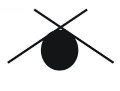
What does this figure indicate on a navigation chart?
(1) West cardinal buoy (2) East cardinal buoy (3) North cardinal buoy (4) South cardinal buoy |
1
|
|
On which side of this buoy should you pass?
(1) South (2) North (3) East (4) West |
1
|
|
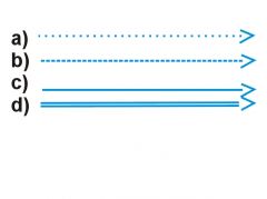
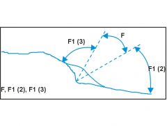
On a navigational chart, how is the probable direction of the predominant direction of sea surface current indicated?
(1) Letter a (2) Letter b (3) Letter c (4) Letter d |
1
|
|
|
A vessel is under pilotage approaching a European port. Who is responsible for the safe navigation of the vessel?
(1) The pilot. (2) The master and duty officers. (3) The traffic controller. (4) The pilot and the master together. |
2
|
|
|
What should a passage plan include?
(1) The plan should include the first 72 hours of the sea voyage. (2) The plan should include the entire voyage from berth to berth. (3) The plan should cover the first half of the sea voyage. (4) The OOW decides what to include in the passage plan. |
2
|
|
|
When must a passage plan be prepared?
(1) Gradually during a sea voyage (2) Before the voyage commences (3) Whenever requested by a pilot (4) Any of the other options |
2
|
|
|
Which of the following options would be considered "good seamanship"?
(1) Using radar when proceeding at full speed in fog. (2) Sounding a fog signal when in clear weather, but approaching a fog bank. (3) Using deck and accommodation lights to indicate the presence of your ship in poor visibility. (4) Proceeding on the port side of a narrow channel to take advantage of a favourable current. |
2
|
|
|
You expect to sight land at 2100. By 2120 no land has been sighted, the visibility is good. What action would you take?
(1) Keep looking out. (2) Call the master. (3) Stop engines. (4) Alter course. |
2
|
|
|
What time is used for the ship's course recorder?
(1) Local time (2) Ship's time (3) GMT (4) Company head office time |
3
|
|
|
Where would you find information about a vessel reporting system for a port which you are about to enter?
(1) Mariner's Handbook. (2) International Code of Signals. (3) Admiralty List of Radio Signals. (4) Ocean Passages for the World. |
3
|
|
|
Which is the more accurate means of position fixing?
(1) A radar range and bearing. (2) Two radar bearings. (3) Two visual bearings. (4) A visual bearing and a radar range. |
3
|
|
|
Why should the largest scale chart available be used for navigational purposes?
(1) Because it uses larger symbols. (2) Because it uses better colour. (3) Because it shows more accurate information. (4) Because the brightest lights are shown. |
3
|
|
|
You see a two flag signal on a ship close-by. What publication would you consult to discover its meaning?
(1) Admiralty List of Radio Signals. (2) Mariner's Handbook. (3) International Code of Signals. (4) Nautical Almanac |
3
|
|
|
You are on watch at night and you stop the main engines. What changes would you make to your navigational lights?
(1) Switch the steaming lights off (2) Switch on three vertical red lights (3) Switch on two vertical red lights and switch off all other navigational lights. (4) Switch on two vertical red lights and switch off steaming lights. |
4
|
|
|
Your vessel is carrying a full cargo of scrap steel. Which item of bridge equipment is likely to be unreliable?
(1) The satellite navigator. (2) The echo sounder.. (3) The gyro compass. (4) The magnetic compass. |
4
|
|

What does this chart symbol mean?
(1) Direction of Prevailing Wind (2) Direction of Traffic Lane (3) Direction of Tidal Stream (4) Direction of Buoyage |
4
|