Reading...
![]()
Play button
![]()
Play button
![]()
Use LEFT and RIGHT arrow keys to navigate between flashcards;
Use UP and DOWN arrow keys to flip the card;
H to show hint;
A reads text to speech;
55 Cards in this Set
- Front
- Back
|
What is some equipment useful in navigation other than a chart?
|
Hand bearing compass, binoculars, notepad, parallel rulers, dividers, stopwatch, pencil, eraser, calculator, protractor, depth sounder, triangle, nautical slide rule, maneuvering board
|
|
|
What does the acronym ATON stand for?
|
Aids to Navigation
|
|
|
What is it called to direct safe passage within very restrictive waters, with continuous reference to landmarks, buoys, soundings, etc?
|
Piloting
|
|
|
Is a general chart showing a section of coastline at a scale of 1:600,000 a large scale or small scale chart?
|
Small scale
|
|
|
A coastal chart showing a small section of coastline in adequate detail to navigate closely with a scale of 1:60,000 would be small scale or large scale?
|
Large scale. Other examples would be Harbor charts which might have scales of 1:2,500 to 1:10,000.
|
|
|
What is this?
|
Green day beacon
|
|

What is this chart symbol?
|
Green Daymark - keep to port on returning
Daymarks are permanently built piling structures which serve as buoys in marking channel limits. Beacons are lighted daymarks |
|
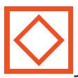
What is this chart symbol?
|
Regulatory marker - danger indicated may be shown on marker. If lighted, light will be white.
|
|
What is this un-numbered red & white marker? What pattern and what color will its light flash?
|
Mid channel marker showing safe water. If lighted, it will be white with Morse code A; short then long flash Mo (A)
|
|

What is this red over green marker?
|
Preferred channel or junctional marker shown at some channel junctions. Shows preferred channel to port if red and to starboard if green. Keep marker to starboard if returning (R/G) and to port if G/R.
|
|

What is this? What do outer and inner rings measure?
|
Compass Rose: outer ring measures from true north; inner ring measurements from magnetic north.
|
|

What type of light is this?
The white is lighted time and the dark is unlighted time. |
Single occulting flashing light. Occulting lights are on more than off (light more than dark)
|
|
|
What does IQ mean on chart?
|

Interrupted quick flashing light on a marker something like this graphic representation.
|
|

What does this symbol mean on a navigation chart?
|

Limit of sector. It could show a limited danger area with a red light or may have multiple colors.
|
|
|
What does Alt WR mean?
Could also say Al. WR or AlWR |

Alternating white and red light on marker.
|
|

What do these symbols represent on a nautical chart?
|
Rock awash at the level of chart datum. Be careful!
|
|

What does this symbol represent on a nautical chart?
|
Wreck showing any portion of hull or superstructure at level of chart datum.
|
|

What does this symbol represent on a nautical chart?
|
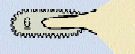
Kelp or seaweed
|
|
What does this symbol represent on a nautical chart?
|
Uncovering or drying heights above chart datum.
Steer clear, dude! |
|

What does this symbol represent on a nautical chart?
|
Submarine (submerged) cable. (Don't get your anchor caught!)
|
|
|
What does this symbol represent on a nautical chart?
_____ __ __ _______ |
International or state boundary
|
|
|
Two permanent beacons located about 100 yards or more apart on shore structures. Back light set higher than front.
|
Transit or Range Lights.
|
|
|
Name at least four published navigation guides from which you can update your chart?
|
Chart #1, Local Notice to Mariners, Navigation Rules;
Light List, Coast Pilot, Cruising Guides, Tide & Current Tables |
|
|
What is a mnemonic for remembering conversion of true, magnetic, compass north using variation and deviation?
|
Timid True North
Virgins (or Virgos) Variation Make Magnetic N. Dull Deviation Company Compass Add Whiskey |
|
|
Positions on the Earth’s surface are described in terms of
A. latitude and longitude. B. latitude and parallels. C. degrees and arcs. D. longitude and meridians. |
latitude and longitude.
|
|
|
Boat speed is:
|
speed on knot meter
|
|
|
Describe mid channel / safe water markers
|
Red & White vertical stripes
not numbered may be lettered to indicate name of harbor entrance, i.e. If lighted, white and in Morse code A _ ___ |
|
|
In regards to currents, "Set" is:
|
Direction towards which current flows
|
|
|
A nautical mile equals _____ statute miles (SM).
A. 1.05 B. 1.15 C. 1.5 D. 1.76 |
1.15
|
|
|
The purpose of parallels of latitude lines is for measuring degrees of latitude
A. east and west of the equator. B. north and south of the equator. C. north and south of the Prime Meridian. D. east and west of the Prime Meridian |
North & South of the equator
|
|
|
Red/Green poss Red light
Green/Red poss Green light |
preferred channel marker
marks junctions of channels |
|
|
At 1 PM DST in New York City, the time is _____ UTC.
(Conversion factor is +5). A. 1600 B. 1700 C. 1800 |
1700
Add conversion factor and subtract one for Daylight Savings Time. Conversion factor in NY is 5. Central Time Zone is 6 Rocky Mountain time 7 Pacific Standard is 8 |
|
|
If you are in Central Standard Time what do you do to convert to Daylight Savings Time?
|
Add one hour to Central Standard.
7 pm CST is 8 pm CDT. |
|
|
How many minutes are there in 1 degree of latitude?
|
60 minutes
|
|
|
The reference line for measuring north-south distances is the
A. great circle. B. prime meridian. C. equator. |
Equator
|
|
|
Mo (A)
|
Morse Code for the letter A
_ ____ dot dash dot dash ... |
|
|
Definition of "Course"
|
Intended direction of travel
|
|
|
The Prime Meridian is the
A. great circle passing through the north and south poles. B. line located at 0° latitude. C. great circle running east and west around the Earth. D. line located at zero degrees (0°) longitude. |
line located at zero degrees (0°) longitude
|
|
|
Definition of "Drift"
|
speed of current in knots
|
|
|
Acronym for Green Buoys
|
COGS
Can, Odd numbers, Green, Square |
|
|
What is "LOP" ?
|
Line of Position
|
|
|
What term denotes a magnetic compass error that is caused by materials within a boat which possess magnetic properties?
|
Deviation
|
|
|
The angular difference between true north and magnetic north at any given place is called?
|
Variation
|
|
|
Time zones are established for every
A. 7 ½° of longitude. B. 15° of latitude. C. 15° of longitude. D. 20° of latitude. |
15 degrees of longitude
|
|
|
How to mark positions for:
EP estimated position Electronic Fix (GPS) RF Running Fix |
Square/Rectangle for EP
Triangle for GPS fix Circle for Running Fix |
|
|
How would these coordinates be read?
a. 29° 40’ N, 35° 53’ W b. 45° 35’ N, 82° 43.2' E |
a. 29 degrees, 40 minutes, north (latitude), 35 degrees, 53 minutes, west (longitude)
b. 45 degrees, 35 minutes, north (latitude), 82 degrees, 43.2 minutes east (longitude) |
|
|
What is "Track" in regards to navigation?
|
Actual path of the boat.
|
|
|
Heading
|
Direction to steer or pointing to stay on course line
|
|
|
Circles parallel to the equator are called
A. great circles. B. parallels of longitude. C. meridians. D. parallels of latitude. |
parallels of latitude
|
|
|
Navigation by reference to visible landmarks is called
A. dead reckoning. B. pilotage. C. radio navigation |
Pilotage
|
|
|
Acronym for Red buoys
|
TERN
Triangle, Even numbers, Red, Nun |
|
|
How do you mark:
Estimated Position GPS determined position Fix based on visible bearings or running fix |

|
|

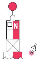
What is this Aid to Navigation?
|
Regulatory Marker
INFORMATION AND REGULATORY MARKERS WHEN LIGHTED, INFORMATION AND REGULATORY MARKS MAY DISPLAY ANY WHITE LIGHT RHYTHM EXCEPT QUICK FLASHING, Mo(A), AND FLASHING (2) |
|
|
Chart Plotting Labels:
course: True and Magnetic Distance: to nearest 0.1 nm Speed to nearest 0.1 kn |
C 080M or C 080T
___________________ S6.0 (D=10) this means 10NM and 6 naughts |
|
|
True speed
|
actual speed WITH effect of current
|