Reading...
![]()
Play button
![]()
Play button
![]()
Use LEFT and RIGHT arrow keys to navigate between flashcards;
Use UP and DOWN arrow keys to flip the card;
H to show hint;
A reads text to speech;
59 Cards in this Set
- Front
- Back
|
What are requirements for a thunderstorm?
|
Warm - warm air lifting action
Wet - moist air Wiggle - unstable atmosphere |
|
|
What are phases of a thunderstorm?
|
Cumulus - updrafts (3000fpm 30mphr)
Mature - rain at surface Dissipating - downdrafts (up to 6000fpm) |
|
|
What are standard temp and pressure values?
|
15 degrees C
29.92" Hg |
|
|
Characteristic of high and low pressure systems?
|
- Low pressure - Inward, upward and counter clockwise
unstable, cloudy, precipitation bad weather. - High pressure - outward, downward and clockwise dry stable descending air good weather. |
|
|
What happens when temp and dew point are close together?
|
visible moister in the form of dew, clouds or fog.
|
|
|
What factor determines the type and vertical extent of clouds?
|
the stability of the atmosphere.
|
|
|
What is the difference between a stable and unstable atmosphere?
|
stable atmosphere resist upward or downward displacement. while unstable allows it.
|
|
|
What are the main types of icing aircraft can encounter?
|
Structural - on structure of A/C
Induction - engine cant breathe Instrument - pitot tube ect. |
|
|
what are the 3 types of structural ice?
|
Clear ice - water drops strike aircraft and slowly freeze
Rime ice - small drops hit aircraft and freeze fast Mix - of both |
|
|
What is freezing level?
|
lowest altitude in the atmosphere over a given location at which air temp reaches 0 degrees Celsius. you can have multiple freezing levels when temp inversion occurs.
- pilot should use icing forecast as well as pireps airmet sigmet weather charts. |
|
|
What is temperature inversion?
|
A temperature inversion is a thin layer of the atmosphere where the normal decrease in temperature with height switches to the temperature increasing with height. Than back to normal decrease after the inversion.
|
|
|
What are squall line thunderstorms?
|
- non frontal narrow band of active thunderstorms.
-often developed ahead of a a cold front in moist unstable air -contains severe steady state thunderstorms -presents most intense wether hazard to aircraft's -forms rapidly reaches maximum intensity during the late afternoon. |
|
|
2 basic ways fog forms?
|
- cooling air to dew point
- adding moisture to air |
|
|
Name several types of fog?
|
- Radiation
- Advection - Precip induced - ice fog - upslope |
|
|
What is a dry line?
|
- The passage of a dry line results in a sharp decrease in humidity, clearing skies, and a wind shift from southeasterly or south to southwesterly or west. Its presence influences severe weather development in the Great Plains.
|
|
|
What is an occluded front?
|
- happen when cold fronts catch up to, and then overtake, the warm fronts ahead of them. The end product is two fronts in one: a front at the surface, and one aloft. Again, widespread cloudiness, precipitation, and thunderstorms are possible
|
|
|
What causes radiation fog to form?
|
-conditions for this include clear sky, little or no wind, small temp dew point spread, high humidity, forms at night or day break.
|
|
|
What is advection fog, and where does it form?
|
- forms when moos air moves over colder ground or water.
-may occur with winds, cloudy skies, over wide geographic area. |
|
|
what is precipitation induced fog?
|
- warm rain or drizzle falls through cool air evaporation from the precipitation saturated the cool air and forms fog.
|
|
|
Define up slope fog?
|
- result of moist, stable air being cooled as it moves up a sloping terrain. once it stops the fog dissipates.
|
|
|
Define Ice fog?
|
- occurs in cold weather when temperature is much below freezing and water vapor sublimates directly as ice crystals.
|
|
|
What is the primary source of obtaining a weather briefing ?
|
- 1800 wx brief
- Fss briefer |
|
|
What are some examples of other sources of weather briefing include?
|
- Telephone information briefing (TIBS)
continues telephone recordings of meteorological and aeronautical info. # located in AFD, route briefings airspace procedures and special announcements. - Direct user accès terminal system (DUATS) |
|
|
what information does a weather brief include?
|
- adverse conditions
- VFR flight not recommended - synopsis - current conditions - enroute forcast - destination forecast - winds aloft - notices to airmen - ATC delay |
|
|
What is EFAS ?
|
- Enroute flight advisory service
- service that provides enroute aircraft with timely and meaningful weather advisory pertinent to the type of flight intended route of flight and altitude. -PIREPS -capable for aircraft flying at 5000AGL to 17500 MSL on 122.0 also know as flight watch. 6am to 10 pm |
|
|
What is HIWAS?
|
- Hazardous In flight weather advisory service
-continues broadcast of in flight weather advisories include weather warnings, SIGMETS, Convective SIGMETS AIRMETS and urgent PIREPS. |
|
|
WHat is a Metar?
|
- routine weather report (hourly)
-Station identifier -date and time of report -modifier (auto or speci) -wind -visibility -RVR -weather phenomena -sky condition -TEMP/Dew point -altimeter -remarks |
|
|
What is a AWOS? ASOS? ATIS?
|
- AWOS (automated weather observing system)
-different levels of AWOS -AWOS-3 is like ASOS but lower levels of AWOS only give limited information ex. only altimeter setting. -ASOS automated surface observation system is a continues min by min observation to generate a metro asks can also spit out a SPECI report when needed. -ATIS busier terminal person recorded, atis contains essential information such as wx info, active runways, app in use, notams and any other essential info. |
|
|
What are PIREPS?
|
-pilot weather reports
-Routine UA -Urgent UUA -location -Time -Place -Flight level in MSL -aircraft type -weather encountered -visibility |
|
|
Define LIFR, IFR, MVFR, and VFR?
|
LIFR : ceiling less than 500ft / visibility less 1m
IFR : Ceiling 500 - 1000ft / visibility 1 - 3m MVFR : ceiling 1000 - 3000ft / visibility 3 - 5m VFR : greater than 3000ft / visibility greater than 5m |
|
|
What is relative humidity?
|
- water vapor present in atmosphere at any given time.
|
|
|
what are the fronts?
|
- front is a transition between to air masses
- weather front is an air mass that has simalr characteristics such as moisture content and temp. |
|
|
What is due point?
|
- temp is lowered to dew point it becomes saturated amd moister begins to condense (liquid)
|
|
|
Characteristics of warm and cold air?
|
- warm air rises
- cold air sinks |
|
|
What are iso bars?
|
- lines of equal pressure
|
|
|
TAF?
|
-5sm form airport
-valid 34/20 hrs -issued 0, 6, 12, 18hrz same info as metar reports in AGL FROM - fast change within hour BECMG - gradual change TEMPO - change expected less than 1 hr but for no more than half the period. PROB - percentage 30(30 -39) 40(40-49) |
|
|
FA?
|
Area forecast gives picture of clouds, general weather conditions, and VMC expected over a large area taking several sates.
-Issued 3 times a day valid for 18 hours. Header - Location, source, date and time, valid times and area coverage Precautionary statements - IFR conditions mountain obscuration, thunderstorm hazards. This is in MSL unless otherwise stated. Synopsis (18hr) - brief summary of location and movement of pressure systems, fronts, and patterns. VFR clouds ans Wx (12hr) - expected sky conditions, visibility, and weather and has outlook also (6hrs) |
|
|
Airmet?
|
valid: 6hrs
Issued: 6hrs 3 types- sierra- mountain obsucration IFR conditions Tango - moderate turbulence sfc winds below 30 knts, low level wind shear. zulu - moderate ice and freezing levels. |
|
|
Sigmet?
|
Valid : 4hrs
issued : as needed severe icing severe turbulence volcanic eruption, dust storms, sand storms, visibility to less than 3 miles. |
|
|
Convective sigmet?
|
valid : 2hrs
issued : as needed -winds 50knts plus -3/4 inch hail -sever ice -severe turbulence -tornados -embedded t-storms -low-level wind shear thunderstorm activity -T-storms with heavy precip effecting 40% of 3000 sqm area or more. |
|
|
Winds temp aloft?
|
- winds and temps for specific locations
- 2 times a day 0000z , 12000z - winds are in true north - winds not issued within 1500 ft of station - no temp within 2500 ft of station - above 24,000 assumed negative - weird numbers -50 +100 rule |
|
|
What is surface analasys chart?
|
issued : every 3hrs
- shows areas of high and low pressure, fronts, temps, dew points, wind direction, local weather and visual obstructions. |
|
|
Weather depiction chart?
|
- starts at 01z transmitted every 3 hrs
-broad overview of observed flying conditions -total sky cover, cloud height, weather obscurations, visibility -idel for flight planing you get a birds eye view or areas of favorable and adverse conditions. |
|
|
Raday summary?
|
issued : hourly
Valid : for 35 min past hour - displays areas or precipitation as well as information about type, intensity, configuration, coverage, echo top, cell movement. - Also weather watch area depicted in heavy dashed lines. |
|
|
Surface prog chart?
|
issued 12, 24, 36, 48 hours
-provides a forecast of surface pressure systems, fronts, precipitation for a 2 day period. - used to obtain an over view of the progression of surface weather within next 48 hours. - upper 2 panels depict significant weather progs for 12 and 24hr. Fronts, pressure systems and precipitation. - lower 2 panels depict surface progs for 12 and 24hr.Fronts, pressure systems and precipitation. |
|
|
convective outlook chart?
|
- Valid till 12z next day
- areas forcast to have tornados, hail 3/4 inch thick, winds of 50 kt or greater, general convective areas. - slight risk - moderate risk - high risk areas |
|
|
Dry Line - a boundary separating moist and dry air masses. It typically lies north-south across the central and southern high Plains states during the spring and early summer, where it separates moist air from the Gulf of Mexico (to the east) and dry desert air from the southwestern states (to the west)
|
|
|
Squall Line - a line of active thunderstorms, either continuous or with breaks, including contiguous precipitation areas resulting from the existence of the thunderstorms.
|
|
|
Trough - an elongated area of relatively low atmospheric pressure; the opposite of a ridge. On WPC's surface analyses, this feature is also used to depict outflow boundaries.
|
|

|
Occluded Front - a composite of two fronts, formed as a cold front overtakes a warm or quasi-stationary front. Two types of occlusions can form depending on the relative coldness of the air behind the cold front to the air ahead of the warm or stationary front. A cold occlusion results when the coldest air is behind the cold front and a warm occlusion results when the coldest air is ahead of the warm front.
|
|
|
Stationary Front - a front between warm and cold air masses that is moving very slowly or not at all.
|
|
|
Tropical Wave - a trough or cyclonic curvature maximum in the trade wind easterlies.
|
|
|
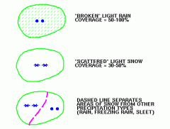
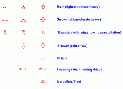
Precip
|
|
|
symbols
|
|
|
Explain the stability charts ? (LIFT INDEX)
|
LI - is the temperature difference between an air parcel lifted adiabatically (no heat exchange) and the temperature of the environment at a given pressure height in the troposphere (lowest layer where most weather occurs) of the atmosphere.
- When the value is positive on the chart, at the respective height the atmosphere is stable (good weather) and when negative it is un-stable. -LI is computed using algorithms and also graphically. |
|
|
What is tweb?
|
- transcribed weather broadcast
- T in upper right corer of Nav/Aid box - weather broadcast over sleected nab/aid - route forecast, forecast outlook, winds aloft ect. - within 50nm of FSS - 4x12 |
|
|
Go / No Go decision ?
|
- can the plane handle this flight?
- ANy thunderstorms in the area? - fast moving fronts or squall line t/s - moderate or great turbulence - fog or visual obscurations - Icing levels - last are you physically and mentally prepared for this flight? |
|
|
SLP 013 ?
|
you either add a 10 or a 9 to the front of the number provided, whichever is noticeably closer to the standard of 1013.2. In this case, you would put a 10 in front of the number (132) and put a decimal in front of the last digit, showing an SLP of 1013.2, conveniently the standard pressure. If, however, the number was something like 982, you should add a nine to the front to get 998.2 (as opposed to 10998.2, which is much further from standard).
|
|
|
T01760158 ?
|
- more precise temp and dew point
- temp 17.6 - dew point 15.8 |